Syria Civil War Map: April 2014 (#12.2) (Premium)

There are newer versions of this map available. To see them, view all Syria updates.

Map of territorial control in Syria's civil war, updated for April 2014. Shows control by government, rebels, ISIS extremists, and Kurdish militias. Includes important sites of recent fighting such as Yabroud, Maloula, Kasab, Azaz, Morek, Al Bukamal, and more.

Download PDF
buy

(Subscribe via Paypal)

PolGeoNow’s popular Syria civil war control maps are back! Here’s the second of our member-exclusive premium updates. 

Developments since our previous Syria map update in January include advances by both the government and the rebels, as well as changes in territorial control for the Islamic State of Iraq and Syria (ISIS).

This map and article are exclusive premium content, available only to members or for individual purchase. Buy now (US$9.99).

Premium article includes:

  • Map of current territorial control in Syria by city, color-coded for the Assad government, rebel groups, ISIS extremists, and Kurdish militias
  • Map includes recent areas of fighting such as Yabroud, Maloula, Kasab, Azaz, Al Bukamal, and more
  • Article summarizing changes since January, with links to the sources of information

Members click here to proceed to article and map

Not a member yet? Subscribe Now!

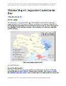
Ukraine Map #3: Separatist Control in the East (Premium)

Updated map of control in Ukraine, as of April 16, 2014. Spotlight on control by separatists in the country's east, including armed takeovers and the claimed Donetsk People's Republic.

Download PDF
buy

(Subscribe via Paypal)

Since our previous Ukraine update ten days ago, there has been a spectacular resurgence of aggressive separatist activity in eastern Ukraine, including not only protester occupations but also armed seizures reminiscent of those that began the Crimea crisis last month.

This is an up-to-date and detailed map of pro-Russian rebel and protester control in Ukraine, including the self-proclaimed “Donetsk People’s Republic”.

This map and article are exclusive premium content, available only to members or for individual purchase. Buy now (US$5.99).

Premium article includes:

  • Ukraine control map updated for the protester occupations and armed rebel takeovers in eastern Ukraine over the past two weeks
  • Shows both protester occupations and armed takeovers, as well as which regions have declared independence
  • Includes a quick briefing on recent events, with links to the sources of information

Members click here to proceed to article and map

Not a member yet? Subscribe Now!

Update: Ukraine Control Overview Map (Premium)

Updated map of control in Ukraine, as of April 5, 2014. Includes final protester occupations, annexation of Crimea, and areas seized by Russian and Ukrainian militaries outside of Crimea.

Download PDF
buy

(Subscribe via Paypal)

This is a brief supplement to our Mar. 4 report, Ukraine Map: Occupations, Autonomy, & Invasion. See that report for a detailed overview of protester occupations and declarations of autonomy in the first two stages of the Ukraine crisis: the anti-Yanukovich Maidan movement and the eastern pro-Russian protests. 

The current article is an update on the current control situation in Ukraine from Mar. 4 to the present. This map and article are exclusive premium content, available only to members or for individual purchase. Buy now (US$5.99).

Premium article includes:

  • Simple updated map of the political situation in Ukraine since Mar. 4
  • Shows the last of the pro-Russian protester occupations, the annexation of Crimea, and seizures by the Ukrainian and Russian militaries outside of Crimea proper
  • Report on the course of events since the last report, explaining each detail shown on the map
  • In-line links to sources of information

Members click here to proceed to article and map

Not a member yet? Subscribe Now!

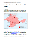
Premium Map Report: Russian Control of Crimea

Map of Russian seizures and military actions in the Crimea region which it recently annexed from Ukraine.

Download PDF
buy

(Subscribe via Paypal)

After a month of low-level conflict, Russian military control of Crimea appears to be nearly complete. Here’s a complete map – to the best of our knowledge – of all locations of Russian seizures and other military actions inside and outside of the Crimea region. This map and article are exclusive premium content, available only to members and for individual purchase. Buy now (US$4.99).

Premium article includes:

  • Exclusive map of Russian seizure and attack locations inside and outside of Crimea
  • Guide to all locations on the map, with brief summary of what has happened at each
  • In-line links to sources of information

Members click here to proceed to article and map

Not a member yet? Subscribe Now!

Crimea Declares Independence: Is It Really a Country?

On Monday, two regional governments on the Crimean Peninsula controversially declared their independence from Ukraine as the new Republic of Crimea. While the declaration has been rejected by most of the world community, and Crimea hopes to swiftly unite with Russia, for now it might be considered a de facto sovereign state. Read on for details.

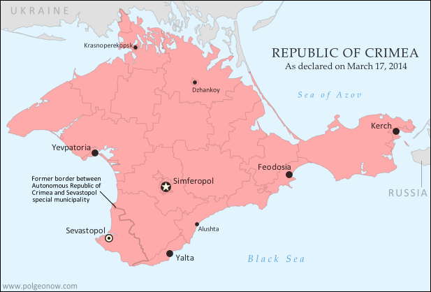
Map of the newly declared independent Republic of Crimea, seceding from Ukraine to join Russia (colorblind accessible).
The Republic of Crimea. Map by Evan Centanni, based on this blank map.

Premium members click here to view this article in the ad-free members area. Not a member yet? Subscribe now!

By Evan Centanni

Declaration of Independence
Following Ukraine’s revolution, the explosion of pro-Russian protests in the east, and the subsequent occupation of the Crimean peninsula by Russian forces (see our premium report, Ukraine Map: Occupations, Autonomy, & Invasion), a new independent country has been declared on the coast of the Black Sea.

The Republic of Crimea’s declaration of independence (English translation) was actually adopted on March 11, but was not to go into effect until and unless endorsed by this Sunday’s popular referendum. Yet sure enough, Crimea’s population, more than half of whom identify as Russians, apparently voted in favor of the split from Ukraine. Many minority Crimean Tatars – and possibly ethnic Ukrainians as well – planned to boycott the vote, though that still doesn’t explain the referendum’s passage by a suspiciously high 97 percent.

It’s difficult to verify whether the election was free and fair, as it was held under military occupation and against the will of Ukraine’s government, with European election observers refusing to participate in validating the outcome. Even some of the regional leaders who arranged it did not come to power legally within the Ukrainian constitution (though they claim the same of the current Ukrainian government in Kiev). Given all these issues, it may never be known whether a majority of Crimea’s people truly do want the split with Ukraine.

See Also: How Sharply Divided is Ukraine, Really? Honest Maps of Language and Elections

Union of Two Regions

Flag of CrimeaCountry Name:  
• Crimea (English)
Krym (Russian, Ukrainian)
Qırım (Crimean Tatar)
Full Name:  
• Republic of Crimea (English) 
• Respublika Krym (Russian, Ukrainian)
• Qırım Cumhuriyeti (Crimean Tatar)
Capital: Simferopol

A political geography detail left out of many reports is the fact that, under the Ukrainian constitution, Crimea is actually divided between two different regional governments. The majority of the peninsula falls under the jurisdiction of the Autonomous Republic of Crimea – a special regional administration with more power than Ukraine’s provinces but less power than a U.S. state. But another sizable chunk is governed by the special municipality of Sevastopol, a city which is not part of any Ukrainian province.

Crimea’s process of exiting Ukraine was endorsed by both the parliament of the Autonomous Republic of Crimea and the city council of Sevastopol, though as previously mentioned, both bodies are led by politicians installed under questionable circumstances during the past few weeks. By agreeing to this declaration, the active governments of the two administrative areas have effectively agreed to unite into a single independent country for now.

Joining Russia
Although the process involves declaring Crimea and independent country, the goal is actually to join Russia as an autonomous republic within that country’s federal system (once united with Russia, Sevastopol will likely return to its status as a separate municipality). Accordingly, the newly declared Republic of Crimea has already applied to join the Russian Federation (i.e. Russia), and Russian president Vladimir Putin has already signed a treaty to allow Crimea’s admission. However, the treaty will need to be ratified by Russia’s parliament before Crimea can become part of the country under Russian law.

International Recognition
The key to acceptance by a new country into the international community is diplomatic recognition from other countries. Given the way it came about, Crimea is unlikely to receive recognition from many of the world’s states. However, it has already joined the club of breakaway states with at least one recognition, after its independence was officially acknowledged by Russia. An independent Crimea has also apparently been endorsed by three other mostly-unrecognized pro-Russian breakaway states: Abkhazia, South Ossetia, and Nagorno-Karabakh.

Is Crimea a Real Country?
Though most lists of the world’s countries include only those with recognition from the United Nations, other proclaimed nations can sometimes be described as de facto (“in actual fact”) independent countries if the reality on the ground shows they aren’t part of any other country. Since Crimea is clearly no longer controlled by Ukraine and is not yet claimed by Russia, it probably could be placed in this category.

Similar cases which are often described as de facto independent countries are Northern Cyprus, which is recognized only by Turkey, and Abzhazia and South Ossetia, which are recognized only by Russia and a few others. These claimed countries may be puppet states – under the close political influence of a neighboring nation – but through history that often hasn’t stopped countries from receiving recognition and even being members of the U.N. (think of eastern Europe during the Cold War, or Iraq and Afghanistan after the U.S. invasions).

A country can be de facto independent without being established through a democratic process or within the laws of the country it’s splitting from. Though unilateral declarations of independence can be tricky to trade in for diplomatic recognition these days, many modern countries were created this way, from Croatia to Bangladesh to the United States. So the questionable circumstances surrounding Crimea’s declaration and referendum don’t actually disqualify it from being considered a country.

In fact, the Crimean declaration of independence made specific mention of Kosovo, another claimed country which declared independence after being occupied by foreign powers – in that case, NATO intervening to protect ethnic Albanians from the government of Serbia. Though Russia has been among the strongest opponents of Kosovo’s independence, supporters of Crimea’s secession from Ukraine have been quick to point to a judgment from the International Court of Justice (ICJ) which ruled that Kosovo’s declaration of independence did not violate international law.

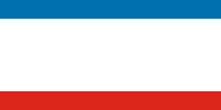
Graphic of the flag of Crimea is in the public domain (source).

How Sharply Divided is Ukraine, Really? Honest Maps of Language and Elections

There’s no question that Ukraine’s current crisis arose from major political divisions in the country, and it’s true that language is an issue. But some online news websites have sensationalized and exaggerated these divisions through misleading maps. PolGeoNow offers a pair of maps that better communicate the blurriness of the supposed lines between western and eastern Ukraine. 

(For a map of current events from January up to this week, including protester control, government occupations, and the Russian invasion, purchase our premium map of the Ukraine crisis or become a member.)
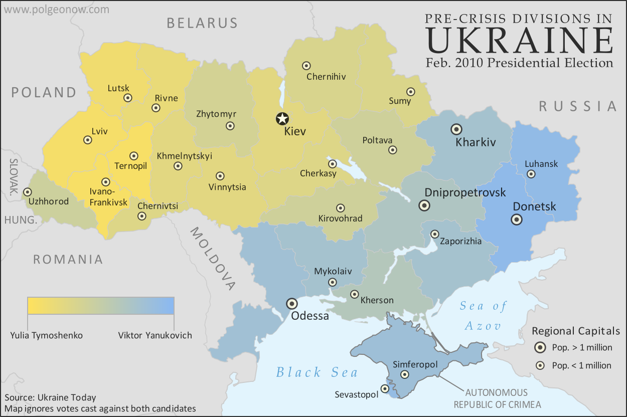
Map of the results of Ukraine's February 2010 presidential runoff election between Yulia Tymoshenko and Viktor Yanukovich
A more honest map of Ukraine’s 2010 presidential election. By Evan Centanni.

Premium members click here to view this article in the ad-free members area. Not a member yet? Subscribe now!

Article by Evan Centanni 

Misleading Ukraine Maps
In January, the Washington Post’s Max Fisher wrote a popular map-illustrated blog post about the political and linguistic divisions fueling Ukraine’s crisis, then at the height of its pro-Europe protest phase. Later, CNN followed the Post’s lead and published a similar set of maps. However, the maps in both articles are designed in a way that makes the divisions look much sharper and more black-and-white than they really are. There’s not, as Fisher preposterously claims, “an actual, physical line” splitting Ukraine in half. Instead, there’s a gradual shading of mixed populations whose ethnic identities and voting history don’t always correlate to the country’s current political divisions.

The 2010 Presidential Election
The centerpiece of Max Fisher’s Washington Post article is a map superimposing early protest information on a map of results from the 2010 presidential election, in which the now-ousted Viktor Yanukovich won a majority over opposition candidate Yulia Tymoshenko. Although Fisher did distinguish in the map between regions voting overwhelmingly for one candidate and regions where the winner received a narrower majority, the sharpness of the east-west division is badly exaggerated by the colors he chose.

Using orange for Tymoshenko and blue for Yanukovich was normal, but the regions with highly-mixed results should have used some color in between. Instead, the map uses light orange for small Tymoshenko victories and light blue for small Yanukovich victories, making regions that actually weren’t far apart in their votes still look sharply separated due to the clashing colors. CNN’s equivalent map is even worse, using bright red and bright blue. With eye-grabbing, clashing colors like that, it’s no wonder someone might think Ukraine is literally bisected down the middle.

But that’s just not the reality. As the map above shows more clearly, many regions, including even some in the west, voted only narrowly for one candidate over the other. The colors don’t transition perfectly smoothly from one end of the country to the other – every region went to one candidate by at least 10 percentage points – but there’s not a sharp dividing line either. A more detailed map, with the districts of each region separately colored, would probably show an even less distinct divide.

So how well do the 2010 election results map to the current crisis? Not too badly. The Lviv region did end up taking a leadership role in the protests against Yanukovich, and Donetsk has been among the forefront of regions opposing him. However, protests did eventually spread across the whole country by February, and there were some exceptions to the yellow vs. blue pattern. If you’d like to make a detailed comparison, check out our political overview map report for the Ukraine crisis, accessible to premium members or by individual purchase.

Map of languages in Ukraine by region (oblast), showing gradation between Ukrainian and Russian languages while marking regions with large proportions of residents with other native tongues
Ukraine is even less clearly cut in half by language. Map by Evan Centanni.

Native Languages: Ukrainian vs. Russian
Both the Washington Post article and the CNN post also feature maps of the languages spoken in Ukraine. CNN does better on this than on the election map, at least choosing somewhat similar orange and red colors in an attempt to show the gradient in the proportion of Russian speakers across Ukraine’s regions. The Post’s Max Fisher, on the other hand, continues with the misleading contrasting colors, cutting Ukraine simplistically into an orange half and a blue half for the Ukrainian and Russian languages.

Most egregiously, Fisher’s map uses the label “Predominantly Russian-speaking” to blanket a number of regions where there are actually more native Ukrainian speakers than native Russian speakers. As the above map shows, Ukrainian is actually the majority language across most of the country. Only four regions – Donetsk, Luhansk, Crimea, and the special municipality of Sevastopol – have more Russian than Ukrainian speakers.

When comparing this map with the election map at top, it becomes clear that language is not as great an indicator of Ukrainian politics as some commentators imply. People whose mother tongue is Russian make up only 30% of Ukraine’s population according to the 2001 census, yet Viktor Yanukovich received more than 49% of the national vote in 2010 (as compared with Tymoshenko’s 45%).

It’s true that the strongest opposition to the new interim government is coming from the regions with Russian-speaking majorities, but there may be a specific reason for this: one of the new revolutionary government’s first acts was to repeal a Yanukovich-era law granting legal rights to minority languages such as Russian. (Note that being “ethnically Russian”, at least in official statistics, is not the same thing as being a native speaker of the Russian language; only 17% of people in Ukraine identify as “Russians”; many of the remaining Russian-speakers identify only as Ukrainians.)
Flag of Ukraine Full Country Name:  
• Ukraine (English)
• Ukrayina (Ukrainian)
Capital: Kiev

Other Major Languages
Another fact left out of the Washington Post and CNN maps is that Ukrainian and Russian are not the only major languages in Ukraine. Although they are by far the most widely-spoken nationwide, within several regions there are other languages which come in second or third. By now many followers of the news know that Crimea has significant population of Crimean Tatars, who speak a language related to Turkish. In the Crimean autonomous region, speakers of Crimean Tatar (11%) outnumbered speakers of Ukrainian (10%) in 2001.

But Crimea isn’t the only region with major minority language communities. In Chernivtsi, Romanian (12%) and Moldovan (7%) both outnumber Russian (5%), and in nearby Zakkarpatsia (capital: Uzhhorod) 13% of residents are native speakers of Hungarian. In Odessa, Ukrainian and Russian are the biggest languages, but Bulgarian (5%) and Moldovan (4%) are also present. (Data from Ukraine’s 2001 census, retrieved here).

Graphic of the Ukrainian flag is in the public domain (source).

Map of the 2014 Ukraine crisis, before and after the ouster of President Yanukovich, updated to March 3, 2014. Details shown include protester occupations, declarations of autonomy, and Russian invasion.

Want to see a comprehensive map of political control in Ukraine’s crisis from January up to this week? Purchase our premium map report for just $5.99.

Or you can become a member, and get access to all our premium content!

Ukraine Map: Occupations, Autonomy, & Invasion (Premium)

Map of the 2014 Ukraine crisis, before and after the ouster of President Yanukovich, updated to March 3, 2014. Details shown include protester occupations, declarations of autonomy, and Russian invasion.

Download PDF
buy

(Subscribe via Paypal)

PolGeoNow begins our Ukraine coverage with this overview of the political situation from January to the present, both before and after the overthrow of President Viktor Yanukovich’s government. Details shown include protester occupations, declarations of autonomy, and Russian invasion. This map and article are exclusive premium content, available only to members and for individual purchase. Buy now (US$5.99).

Premium article includes:

  • Exclusive map of the political situation in Ukraine’s 2014 crisis
  • Shows protester occupations, regional capitals overrun, autonomy declarations, and locations of Russian military siege
  • Report on the course of events, explaining each detail shown on the map
  • In-line links to sources of information

Members click here to proceed to article and map

Not a member yet? Subscribe Now!

South Sudan War Map: Control at Time of January Ceasefire (Update #3) (Premium)

Map of rebel control in South Sudan's ongoing rebellion, showing situation at the time of the ceasefire of January 23, 2014

Download PDF
buy

(Subscribe via Paypal)

This is Part 1 of a double map report on territorial control in South Sudan’s ongoing rebellion, available exclusively to premium subscribers or for individual purchase. This map shows territorial control as of January 23, when the warring parties signed their ceasefire agreement (including major changes from previous update). Buy now (US$3.99).

To see the map of current control as of late February, go to Part 2.

Premium article includes:

  • Exclusive map of rebel control at the time the ceasefire was signed on January 23, 2014
  • Multiple changes to territorial control since previous update
  • Several new locations added to the map
  • Report chronicling changes to territorial control and describing the situation at the time of the ceasefire, including links to sources

Members click here to proceed to article and map

Not a member yet? Subscribe Now!

South Sudan War Map: Current Rebel Control (Update #4) (Premium)

Map of rebel control in South Sudan's ongoing rebellion, showing situation at the time of the ceasefire of January 23, 2014

Download PDF
buy

(Subscribe via Paypal)

This is Part 1 of a double map report on territorial control in South Sudan’s ongoing rebellion, available exclusively to premium subscribers or for individual purchase. This map shows current territorial control for late February 2014, including several changes since the time of the ceasefire. Buy now (US$3.99).

To see the map of control at the time of the ceasefire on January 23, see Part 1.

Premium article includes:

  • Exclusive map of current rebel control up to February 21, 2014
  • Multiple changes to territorial control since previous update
  • Several more new locations added to the map
  • Report chronicling changes to territorial control since the ceasefire, including links to sources

Members click here to proceed to article and map

Not a member yet? Subscribe Now!

Syria Civil War Map: January 28, 2014 (#12.1) (Premium)

There are newer versions of this map available. To see them, view all Syria updates.

Map of fighting and territorial control in Syria's Civil War (Free Syrian Army rebels, Kurdish groups, Al-Nusra Front, ISIS/ISIL and others), updated to January 28, 2014. Includes recent locations of conflict between ISIS and other rebel groups, including Raqqa, Jarabulus, Manbij, Kafranbel, and others.

Download PDF
buy

(Subscribe via Paypal)

PolGeoNow presents our first premium Syria map, part of our new more frequent updates for the Syrian Civil War! Since last month a major struggle has emerged between ISIS extremists and a coalition of other rebel groups, with several key towns changing hands. See the updated map and briefing in this premium report. Buy now (US$5.99).

Members click here to proceed to article and map

NOT A MEMBER YET? SUBSCRIBE HERE!