Mali Conflict Map: Gao and Timbuktu Retaken (January 2013)

There are newer versions of this map available. To see them, view all Mali maps.   

This is an update of our Mali conflict map – for the original story, see Mali Map: Islamist Control & French Intervention.
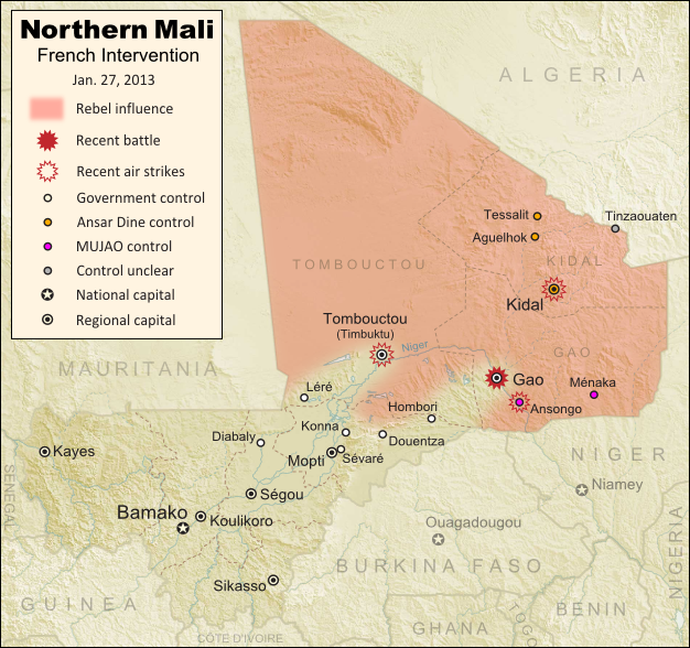
Updated map of fighting and territorial control in Mali during the January 2013 French intervention against the Islamist forces of Ansar Dine and MUJAO. Reflects the Jan. 26-27 recapture of major northern cities Gao and Timbuktu by French and Malian forces.
Updated map of territorial control and fighting in Mali, as of Jan. 27, 2013. Map by Evan Centanni, modified from Wikimedia map by Orionist, using images by Carport and NordNordWest (source). License: CC BY-SA.

French-Malian troops capture two major northern cities
Events have proceeded quickly in Mali’s ongoing war since the France’s military intervention against radical Islamist rebels began just over two weeks ago. This weekend, French and Malian troops recaptured Gao and Timbuktu, two of the three major towns seized by separatist rebels last spring and taken over by radical right-wing militias a few months later.

After taking back most of the country’s central region earlier this week (See: Mali Map Update 2: Douentza Secured by Government), the allied French-Malian forces proceeded northeast from Diabaly and Douentza. On Friday, they took the town of Hombori on the road to Gao, even as Al Qaeda linked MUJAO rebels destroyed a bridge near the border with Niger in order to obstruct a looming invasion by Nigerien and Chadian troops.
Flag of MaliCountry Name:  
• Mali (English, French, Bambara)
Official Name:  
• Republic of Mali (English)
• République du Mali (French) 
• Mali ka Fasojamana (Bambara)
Capital: Bamako

On Saturday, the French and Malian armies seized Gao itself, where they seem to have encountered a limited amount of resistance from the rebels of MUJAO. Many of the militants had already fled the major cities after weeks of French airstrikes against their positions, and on Sunday the allied troops swept quickly through Léré and all the way to Timbuktu, where they are reportedly now establishing control.

Also in the past week, a major faction of the rebel group Ansar Dine defected, forming a new organization called the Islamic Movement for the Azawad. The new faction, dominated by Malian Tuareg people, claims to renounce Islamic extremism, instead saying they want to negotiate peacefully for increased autonomy in the country’s north.

Meanwhile, the French and Malian armies are receiving increasing support from other countries. The U.S., though not directly involved in the conflict, has been providing logistical support to the French military. And several days ago, troops from the neighboring country of Burkina Faso became the first foreign African forces to be deployed alongside the Malian and French contingents (though they still aren’t on the front lines).

On a darker note, accusations have spread of ethnically-motivated murders of Tuareg and Arab civilians by the Malian military (the northern rebels are mostly Tuareg and Arab people). This comes amid the mysterious barring of foreign journalists from towns occupied by the Malian and French forces. Officials have denied any knowledge of such killings, but human rights organizations have been increasingly raising alarms over the alleged abuse.

Original Story: Mali Map: Islamist Control & French Intervention

Recommended Reading: In Mali, Diabaly residents helped repel Islamist militants

Graphic of Malian flag is in the public domain (source).
Mali Conflict Map: Douentza Secured by Government (January 2013)

There are newer versions of this map available. To see them, view all Mali maps.   

This is an update of last week’s Mali conflict map – for the full story, see Mali Map: Islamist Control & French Intervention.

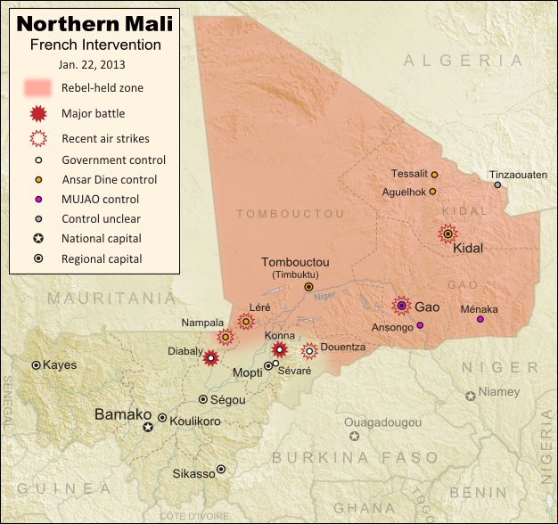
Updated map of fighting and territorial control in Mali during the January 2013 French intervention against the Islamist forces of Ansar Dine and MUJAO. Reflects the Jan. 21 recapture of central town Douentza by French and Malian forces.
Updated map of territorial control and fighting in Mali, as of Jan. 22, 2013. Map by Evan Centanni, modified from Wikimedia map by Orionist, using images by Carport and NordNordWest (source). License: CC BY-SA.

Key Central Town under French-Malian control
The ongoing French-led war against right-wing Islamic insurgents in northern Mali has achieved another victory. Douentza, probably the most important of the central Malian towns formerly held by the rebels, has now been secured by government and French forces. The allied troops reportedly found that the rebels had already left ahead of them, presumably fleeing the French airstrikes that targeted the town over the last week.

Douentza’s status had been a matter of uncertainty for some time, starting with apparently false claims of its capture by the Malian army on the eve of the French intervention. It had been held by the Movement for Unity and Jihad in West Africa (MUJAO), the more extreme of the two main rebel groups controlling territory in northern Mali (and the more closely connected to Al Qaeda).

The capture of Diabaly town has also been fully confirmed now, after a few days of confusion. It had been reported that there was fighting on the ground between French and rebel forces, but residents of the town say it was mainly airstrikes that drove the militants out.

Meanwhile, forces from both France neighboring African countries have continued to arrive in Mali to fight the rebels. French troops in the country now number over 2,000, while African troops from Nigeria, Togo, Benin, Niger, and Chad currently total about 1,000. Chadian and Nigerien troops are also amassing in Niger near the Malian border, from where they may open up a new front by crossing the border to take Gao, the region’s largest city and currently the headquarters of MUJAO.

Original Story: Mali Map: Islamist Control & French Intervention

Recommended Reading: Behind Mali’s conflict: myths, realities & unknowns (commentary from an expert in Mali)

Mali Conflict Map: Hardline Rebels Lose Two Towns (January 2013)

There are newer versions of this map available. To see them, view all Mali maps.   

This is an update of yesterday’s Mali conflict map – for the full story, see Mali Map: Islamist Control & French Intervention.

Updated map of fighting and territorial control in Mali during the January 2013 French intervention against the Islamist forces of Ansar Dine and MUJAO. Reflects the Jan. 18 recapture of Konna and Diabaly towns by French and Malian forces.
Updated map of territorial control and fighting in Mali, as of Jan. 18, 2013. Map by Evan Centanni, modified from Wikimedia map by Orionist, using images by Carport and NordNordWest (source). License: CC BY-SA.

Rebels Lose 2 Towns to French-Malian Forces

The French intervention in Mali has finally resulted in territorial gains for the government, after the two central towns of Konna and Diabaly were reportedly retaken by French and Malian troops today. Mali had incorrectly claimed the recapture of Konna earlier this week, and Diabaly was actually seized by the Islamic extremist rebels after French forces arrived. Local sources have now confirmed both towns to be under government control.

Also today, troops from a Nigerian-led West African force finally began arriving in the country (though they have not yet joined in the combat). Meanwhile, a hostage crisis continued into its third day in neighboring Algeria, where militants closely linked to Al Qaeda have taken over a natural gas field and captured its crew of international workers. By some accounts the militants have demanded an end to the French intervention in Mali, though the location of the gas field is far from Mali’s borders, and they are believed to have attacked from within Algeria.

Full Story: Mali Map: Islamist Control & French Intervention

Mali Conflict Map: France Begins Intervention Against Religious Hardline Rebels (January 2013)

There are newer versions of this map available. To see them, view all Mali maps.   

Islamic extremist militants have ruled Mali’s vast northern region almost unopposed for half a year, after driving out the secular Tuareg-majority separatists who briefly declared an independent country there last spring. But everything changed last weekend, with a new rebel offensive and surprise French military intervention that have kicked the war back into full gear. Read on for a summary of events.

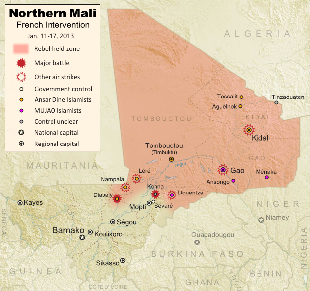
Map of fighting and territorial control in Mali during the January 2013 French intervention against the Islamist forces of Ansar Dine and MUJAO
Current territorial control and fighting in Mali (including French intervention). Map by Evan Centanni, modified from Wikimedia map by Orionist, using images by Carport and NordNordWest (source). License: CC BY-SA.

Map Updates: Check our Mali channel for frequent updates to this map.

Northern Mali in Rebel Hands
The rebellion in northern Mali began as a separatist struggle led by the National Movement for the Liberation of Azawad (MNLA), a secular group of mostly Tuareg ethnicity who last spring successfully seized Mali’s north and declared independence as the State of Azawad. But their victory was soon hijacked by Ansar Dine, a hard-line Islamist militia (also led by Tuaregs) that had fought alongside them previously. Ansar Dine was then joined by MUJAO, an Al Qaeda offshoot group, who swiftly expelled the MNLA from the region. (See: Independent Azawad No More: Northern Mali in Islamist Hands)

The closely allied Ansar Dine and MUJAO remained comfortably in control of northern Mali for the next half year. Citizens accused of immorality were brutally punished under an extreme interpretation of Islamic law, and ancient historical sites were destroyed for allegedly being un-Islamic. Meanwhile, Al Qaeda in the Islamic Maghreb (AQIM), the global terror organization’s Northwest African branch, was allowed to operate freely in the region. The U.N. Security Council eventually authorized a military intervention to be led by neighboring countries, but it was not expected to begin until next September at the earliest.

Further Reading: Making Sense of Mali’s Armed Groups (guide to militias from both sides)

Flag of MaliCountry Name:  
• Mali (English, French, Bambara)
Official Name:  
• Republic of Mali (English)
• République du Mali (French) 
• Mali ka Fasojamana (Bambara)
Capital: Bamako

War Breaks Out
Everything changed last week, when Ansar Dine and MUJAO began an allied push to extend their territory southward towards Mali’s capital. On Thursday, the Malian army claimed (incorrectly) to have captured the important town of Douentza from the rebels, but in fact it was soon the Islamists who had taken new territory, the small central town of Konna.

Panic ensued as it appeared Sévaré, which hosts a critical military airport, and Mopti, a regional capital for central Mali, would be next. But the next day, the tables suddenly turned with the surprise arrival of hundreds of French troops (responding to a request from Mali’s president). At the same time, news hit that supporting forces from neighboring West African countries would be arriving within days.

Over the following night, French and Malian forces claimed to have taken Konna back from the rebels, amid a series of airstrikes against Islamist positions. However, by Monday the extremists had captured Diabaly, the nearest town yet to Mali’s capital and major population centers (though perhaps not as significant as it appears); and by Tuesday, the French government was denying that its forces had even recaptured Konna.

The situation in Mali is continuing to change by the hour (Diabaly is now reportedly surrounded by French and Malian troops, and there are unverified claims that Konna has finally been recaptured). Political Geography Now will be releasing frequent updates to the map as the conflict plays out. Stay tuned!

(To see only posts related to this conflict, you can filter the site for all Mali articles).

Note on Names:  
The acronym “MNLA” is based on the French name, and is sometimes rendered “NMLA” to match the English. 
“MUJAO” is also a French-based acronym. The English acronym is “MUJWA” (or sometimes “MOJWA”). 
Ansar Dine is pronounced “an-SAR (uhd)-DEEN” and sometimes spelled “Ansar Eddine” or “Ansar ud-Dine”. 
AQIM is also known by its French acronym “AQMI”; its Arabic actually means “Al Qaeda in the Islamic West”.

Graphic of Malian flag is in the public domain (source).
Central African Republic: Map of Rebel Control (January 2013)

Last month, rebels in the Central African Republic launched a sudden military campaign against the government, rapidly taking over city after city in their advance towards the capital. Fighting has now come to a temporary halt, with much of the country under rebel control. Read on for a summary of the conflict so far. 

Map of 2012-2013 rebellion in the Central African Republic, showing current rebel control as of January 11, 2013
Advance of Séléka rebels in the Central African Republic during December 2012 and January 2013. Map fact-checked and modified by Evan Centanni from this map by Wikimedia user Keitsist. License: CC BY-SA

Updated Map: Central African Republic – Map of Rebel Control (March 2013)

Rebellion in the Central African Republic
In 2007, a three-year civil war came to an end in the Central African Republic (CAR) when the government reached a peace agreement with several rebel groups. Yet six years later, some of the rebels feel that the government has still not honored its side of that agreement, and last month violence broke out once again.

The new fighting was initiated by a coalition of rebel groups calling itself “Séléka”, which means “alliance” in Sango, the national language of the CAR. The rebels have threatened to depose President François Bozizé, who took power in a 2003 coup but has since won two controversial elections.

More Background: BBC News Q&A – Central African Republic’s rebellion

Rebel Advance from the North
The rebel campaign began on December 10, when they took over N’Délé, a regional capital in the country’s north, which had been under the control of a government-allied former rebel group. At the same time, the new rebel coalition captured two other northern towns, Ouadda and Sam Ouandja. A week later, they stormed into Bria, a diamond-mining town and regional capital in the country’s east. By this time, their forces in N’Délé had also advanced south to capture the town of Bamingui.

Flag of the Central African RepublicCountry Name:  
• Central African Republic (English)
• Centrafrique (French)
• Bêafrîka (Sango)
Official Name:  
• Central African Republic (English)
• République centrafricaine (French)
•Ködörösêse tî Bêafrîka (Sango)
Capital: Bangui

Despite the Central African government receiving reinforcements from its ally and neighbor Chad, the Séléka rebels continued on the road to Bangui, taking the towns of Kabo and Batangafo in the next two days after the Bria attack (despite some sources indicating towns being retaken, government forces no longer seem to be in control of these places; however, rebel forces may not maintain a strong presence either).

In the following days, Séléka’s forces moved west from Bria, seizing the town of Ippy on the way to Bambari. The latter city, among the country’s largest, fell to the rebels on December 23. Central African government forces subsequently attempted to retake Bambari, but were held them back. Two days later, Séléka forces in the north captured another regional capital, Kaga-Bandoro, after only brief resistance.

The seizure of Bambari and Kaga-Bandoro paved the way for Séléka to advance on Sibut, the last regional capital on the road to Bangui. It was soon reported that the rebels had bypassed Sibut to avoid Chadian forces stationed there, and had instead proceeded to the next major town, Damara. However, a few days later rebel forces seized Sibut, and it became apparent that Damara was in fact still government-held, with Central African and Chadian troops having pulled back to there from Sibut.

Standoff and Ceasefire in the South
The rebels are now using Sibut as their forward base, while forces from neighboring countries are amassing in Damara as a firewall against any invasion of the national capital, Bangui. A contingent has also arrived from more distant South Africa. Aside from the rebel capture of Alindao (and possibly one other small town) near Bambari, fighting has come to a standstill since the end of December.

A temporary ceasefire was finally reached on Thursday between the Central African Republic government and Séléka, with word of a possible unity government in the near future if talks proceed smoothly. Political Geography Now will be watching the situation closely, and reporting promptly on any new territorial developments.

Graphic of the flag of the Central African Republic is in the public domain (source).