Taiwan Loses “Recognition” from El Salvador (Map)

You can always find the latest version of this map, and a list of all related articles, on our Which Countries Recognize Taiwan? page.
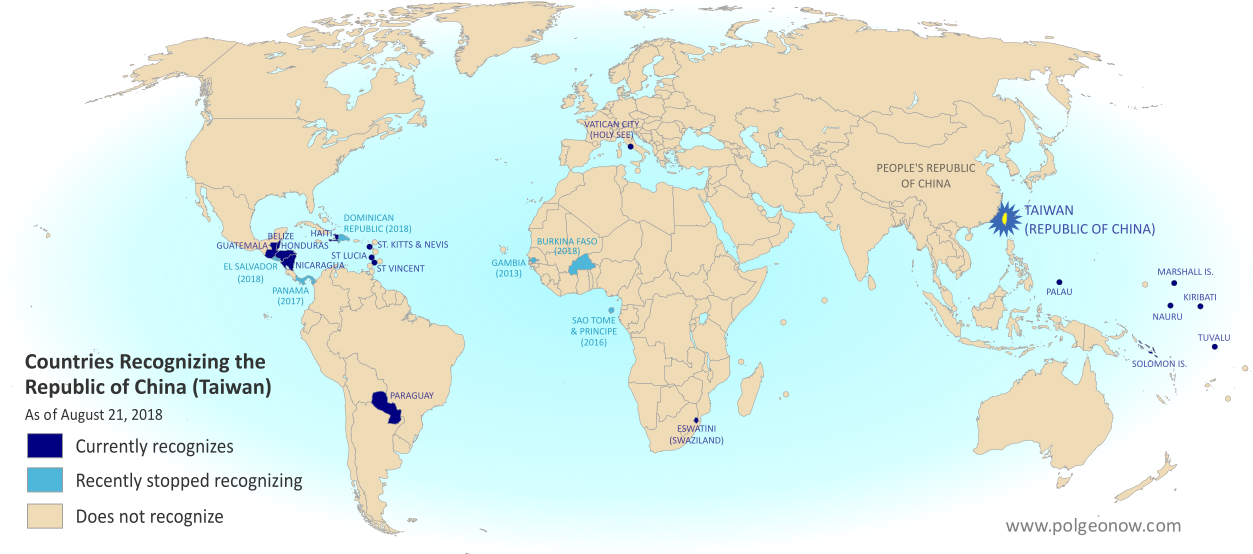
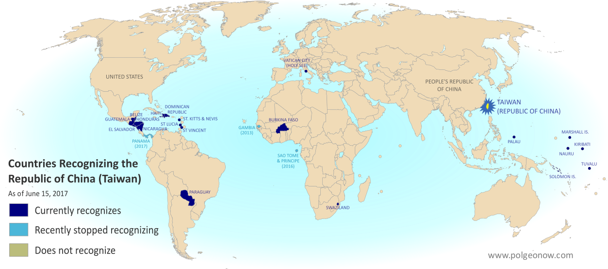
Map of who recognizes Taiwan (what countries recognize the Republic of China) in August 2018. Marks countries that have cut diplomatic ties with Taiwan (withdrawn recognition) in the last ten years: El Salvador, Burkina Faso, the Dominican Republic, Panama, Sao Tome and Principe, and the Gambia. Also answers question: Where is Republic of China located? (Colorblind accessible)
Click to enlarge. By Evan Centanni, modified from public domain blank world map.
Contact us for permission to use this map.

Article by Evan Centanni

El Salvador Drops Taiwan

Flag of the Republic of China (Taiwan) Short Name (informal):  
• Taiwan (English)
• ROC (English)
• Táiwān (Chinese)
Official Name (in constitution):  
• Republic of China (English)
• Zhōnghuá Mínguó (Chinese)
Other names used officially:  
• “Republic of China (Taiwan)” (government offices)
• Chinese Taipei (international sports)
• Taiwan, Province of China (used by UN without Taiwan’s input)   
Capital: 
Taipei (de facto)
Claimed by: People’s Republic of China 

Disputed Taiwan lost its official endorsement from the Republic of El Salvador today. The small but densely-populated Central American country is cutting ties with Taiwan’s government in favor of setting up relations with Mainland China, becoming the latest to endorse the Mainland’s claim that Taiwan is part of China.

In a novel twist, reports said Taiwan’s government “pre-emptively” cut ties with El Salvador just hours before the Salvadoran government publicly announced the switch. But the move was still based on a decision by El Salvador, which Taiwan officials said had been holding talks on the possibility since June.

Is Taiwan a Country?

The islands of Taiwan operate like an independent country today, but are governed under the constitution of the “Republic of China” (ROC), the government that ruled Mainland China before the country’s communist revolution (the administration that now rules the Mainland is called the People’s Republic of China, or PRC).

Since 1991, Taiwan’s government has sought recognition separate from Mainland China in the UN, without challenging the PRC’s right to the Mainland. But because the Mainland government insists Taiwan can’t be separate, it cuts ties with any countries that set up relations with Taiwan, even if they want to stay friends with China too.

“Economic Reasons”

El Salvador’s government is calling its shift away from Taiwan the only reasonable choice in a world where China is one of the most powerful economies, saying that it will bring more opportunities in the future. El Salvador has never before had diplomatic relations with the PRC. Alluding to the fact that the ROC no longer governs most of China, a Salvadoran spokesman was quoted as saying, “El Salvador can’t turn its back on international reality.”

Taiwan’s government, on the other hand, described more specific motivations. The disputed country’s foreign minister accused El Salvador’s president of asking Taiwan to fund his re-election campaign, and said the Salvadoran government had also backing for an expensive port construction project that would have left both countries in debt. (Some speculate that if China steps in to fund the port, it could eventually host the first Chinese military base in the Americas.)

Though Taiwan’s dwindling list of diplomatic contacts may not be a critical threat to its self-governing status, these changes are not merely symbolic. Even aside form the economic ramifications for El Salvador, many average people on both sides may be affected. For example, Salvadoran students in Taiwan are about to see their studies cut short, being forced to either transfer to Mainland China or return home.

Learn More: What Exactly is Taiwan, and Do Countries Really “Recognize” It?

Republic of China: Shrinking Recognition

Today, only 17 countries in the world (about 9%) still have formal diplomatic relations with the Taiwan-based “Republic of China” government – the closest equivalent to officially “recognizing” Taiwan as a country. That includes 16 United Nations (UN) member countries plus UN observer state Vatican City.

El Salvador is the fifth country to drop Taiwan since the current ROC president, whose platform involves resisting Mainland Chinese influence, took office in 2016. Before El Salvador, the last four countries to switch to China were the Dominican Republic and Burkina Faso this May, Panama in June 2017, and São Tomé and Príncipe in December 2016.

Only one country, the Gambia, abandoned Taiwan between 2008 and 2016, during a “diplomatic truce” initiated by Taiwan’s most Mainland-friendly president (even then, the PRC waited until Taiwan elected its current president before restoring its own relations with the Gambia).

Graphic of the Republic of China (Taiwan) flag is in the public domain (source).
Map: Costa Rica & Nicaragua Settle Border Dispute in Court

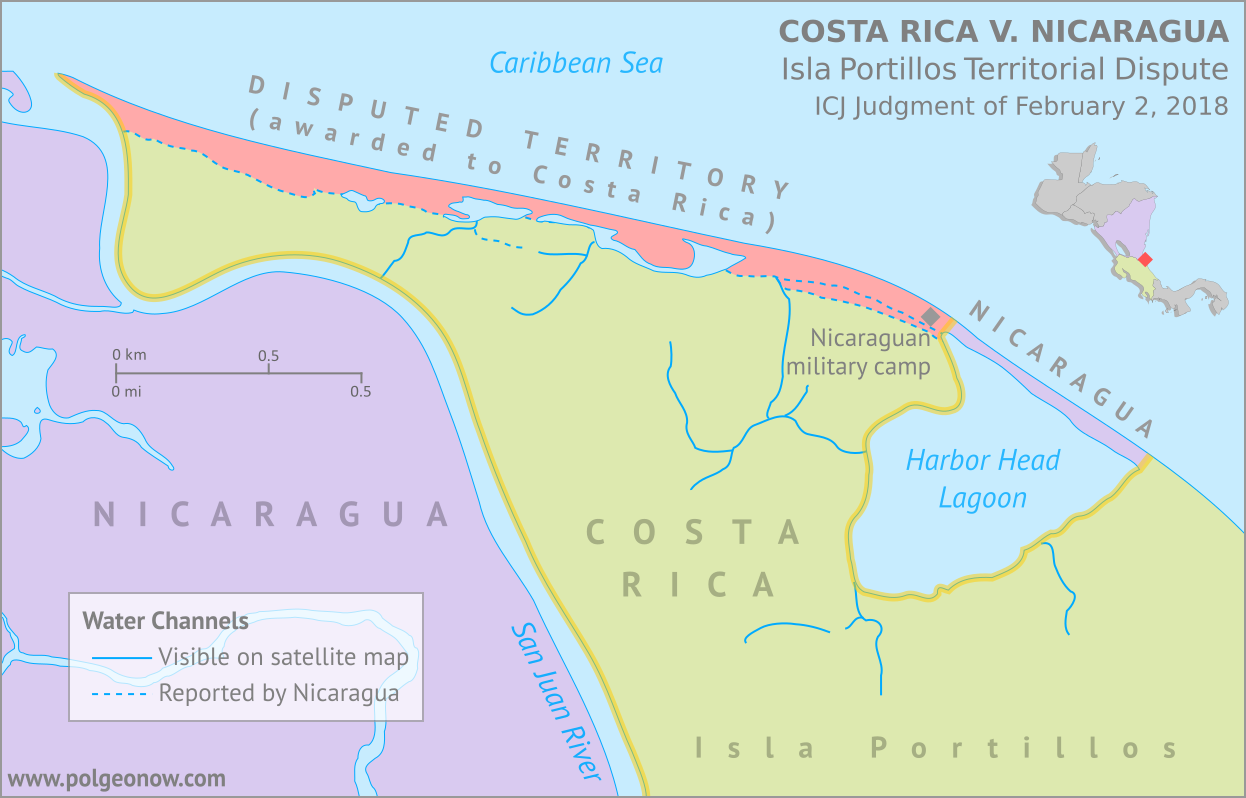
Conflicto Isla Portillos - mapa 2018. Map of Costa Rica and Nicaragua's post-2015 territorial dispute on Isla Portillos at the mouth of Rio San Juan, showing the judgment of the International Court of Justic (ICJ) of February 2018, based on the case filed in 2017. Includes key features such as Harbor Head Lagoon, the Nicaraguan military camp, the disputed territory along the beach, and the small water channels used to argue Nicaragua's case. Colorblind accessible.
Map by Evan Centanni, based on materials submitted to the court. Contact for usage permissions.

World Court Rules on Costa Rica vs. Nicaragua

What happens when two countries draw their border along a river, then the river changes course? The world got to find out yesterday, as the UN’s International Court of Justice (ICJ) released its judgement on a border dispute between Nicaragua and Costa Rica. Though the court’s ruling was dominated by a related request to define the two countries’ borders at sea, it also involved a tiny sliver of land in a temperamental river delta.

The Isla Portillos Dispute

The disputed land territory involves a slice of coastline at the northern tip of Isla Portillos, an island located in the delta of the River San Juan de Nicaragua (Isla Portillos is sometimes considered part of the larger Calero Island). The border once ran along the river and into a lagoon before hitting the Caribbean Sea, but a hundred years of natural changes to the area’s geography messed that all up.

In this court case – the latest of several between the two countries – Nicaragua claimed that a tiny channel of water still connected the river to the lagoon, separating a narrow strip of Nicaraguan coastline from the island’s Costa Rican interior. But Costa Rica argued that the channel, if it even existed, had been artificially built by Nicaragua, and that the Nicaraguan sandbar that once did exist had long ago eroded away. In this view, a small Nicaraguan military camp on the beach – recently moved from the mouth of the lagoon to a spot slightly farther west – was an illegal occupation of Costa Rican territory.

Flag of Costa Rica (civil)Country Name:  
• Costa Rica (English, Spanish)
Official Name:  
• Republic of Costa Rica (English)
• República de Costa Rica (Spanish)
Capital: San José

Costa Rica admitted that the lagoon itself, and the piece of beach now separating it from the sea, still belonged to Nicaragua, leaving a tiny piece of Nicaraguan territory separated from the rest of the country. Even so, Costa Rica warned that Nicaragua might even lose all of that if the beach erodes away completely (international law doesn’t normally allow a country to claim a body of water without owning some piece of land next to it).

Judgement Day: Who Owns the Beach on Isla Portillos?

When it released its decision this yesterday, the ICJ agreed with Nicaragua that the status of the disputed territory hadn’t already been decided by earlier court rulings. But in the end the judges sided almost entirely with Costa Rica, agreeing that the beach between the lagoon and the mouth of the river are Costa Rican. In a decision made by a vote of fourteen to two, Nicaragua was left with just the lagoon and its short strip of beach, and was ordered to move the military camp off of Costa Rican land.

In an unusual move, the court also decided that the sea just outside of the lagoon would be Costa Rican waters. Normally, any coastline controlled by a country automatically gives it the rights to at least some of the neighboring waters, and denying that to Nicaragua might turn out to be controversial.

The Story of a Border Dispute

The tale of the Isla Portillos dispute goes back almost 200 years, involving a US president, a Confederate general, and a lot of creative geographical analysis.

Costa Rica and Nicaragua declared independence from Spain together in 1821, and went their separate ways after the Federal Republic of Central America fell apart in 1838. But from early on, they scuffled over exactly which land belonged to which country. In 1858, they set out to end the disputes by precisely defining the course of their border in the Cañas–Jerez Treaty of Limits.

That treaty set the right bank of the San Juan River as the border in the Caribbean coastal area, with the boundary ending at a spot called Punta Castilla by the river’s mouth. After bringing in US President Grover Cleveland as a mediator from 1886 to 1888 to settle remaining disputes over the treaty’s validity, plus the exact location of Punta Castilla, the border seemed to be settled once and for all.

>Only one problem: Rivers change course over time. By 1896, when the Costa Rican and Nicaraguan governments set out to actually mark their border with pillars on the ground, the end of the San Juan River had split into three separate channels, hitting the ocean kilometers apart from each other. Naturally, each country chose whichever border interpretation gave it the most land, leaving the intervening islands disputed once again.

Map of the border between Nicaragua and Costa Rica at the Caribbean mouth of the San Juan River as decided by the 1897 Alexander award, including prior claims by each country. Includes Harbor Head Lagoon, the Taura Branch of the San Juan River, and the island now known as Isla Portillos.
Click to enlarge: Map of General Alexander’s 1897 border decision, and the Nicaraguan and Costa Rican claims of the time. The largest island, cut off by the Taura Branch, is Isla Portillos. Public domain illustration (source).

Still, it was no surprise that some disputes would come up in the process of marking out the border, and that’s why they had another third-party mediator on hand.

Grover Cleveland – US president again after a break from 1888-1893 – couldn’t participate in person, so instead he sent his friend Edward Porter Alexander, an engineer and former Confederate general from the US Civil War.

General Alexander decided the border should run as close as possible to the original Punta Castilla spot, now located at the northeastern corner of Harbor Head Lagoon on the San Juan’s middle channel. Realizing the river’s course would keep changing in the future, Alexander specified that the future border should always follow the east side of the lagoon and then continue up “the first channel met” into the San Juan River proper.

The Dispute Enters the 21st Century

Alexander’s solution continued to work for about a century. But over the decades Punta Castilla was swallowed by the sea (its original location now lies about a kilometer straight out to sea from the edge of the lagoon), and by the 2000s, another problem had come up: Harbor Head Lagoon wasn’t connected to the San Juan River at all anymore. Or was it?

Nicaragua claimed it had found a tiny channel through the forest connecting the lagoon to the river even more directly than before (“the first channel met”, remember?). This left the whole northern tip of Isla Portillos, roughly from the lagoon westward, as the supposed territory of Nicaragua. The dispute came to a head in 2010, when a Nicaraguan military commander infamously used Google Maps to argue that his troops had the right to land on Isla Portillos and begin dredging operations there.

Flag of NicaraguaCountry Name:  
• Nicaragua (English, Spanish)
Official Name:  
• Republic of Nicaragua (English)
• República de Nicaragua (Spanish)
Capital: Managua

Costa Rica took Nicaragua to court at the ICJ over its actions, and in 2015 the judges agreed with Costa Rica: The newly-claimed channel wouldn’t fly, and the Nicaraguan troops would have to leave. Costa Rica took this to mean the entire island was Costa Rican, except for the lagoon, which was directly mentioned in the border treaty, and the strip of beach that now separated the lagoon from the sea. But the court made a point of not drawing exact borders, and took a pass on saying who owned the island’s narrow coastal strip.

Back to Court: The 2017-2018 Dispute

Soon, Nicaragua began arguing that a tiny piece of the original river channel still ran just behind the beach, connecting the lagoon to the present river mouth. Costa Rica insisted the strip of Nicaraguan land north of the channel had long ago eroded into the sea, and there was only a “channel” remaining behind the beach if Nicaragua had dug a new one farther back.

In 2017, Costa Rica took Nicaragua back to court over the disputed strip of coastline, and yesterday the judges again took the side of Costa Rica, by a vote of fourteen to two. They concluded that there is no more channel, and that the whole beach is Costa Rican except for the part directly between the lagoon and the Caribbean Sea – now a tiny enclave of Nicaraguan territory separated from the rest of the country.

So the dispute is resolved again, for now. But one thing’s for sure: We haven’t seen the end of changes to the area’s riverbanks and coastlines. It’s probably just a matter of time before a new variation of this centuries-old territorial dispute pops back up. Judge Awn Al-Khasawneh, who voted against awarding the land to Costa Rica, and felt the court should have come up with a more permanent solution, quoted medieval Persian poet Hafez of Shiraz in his dissenting opinion: 

“The house of hope is built on sand…”

Need ALL the details? You can find complete documentation of the court case on the ICJ website: records for the Isla Portillos case here, with the judgement and related documents here.

Panama Recognizes China, Stops Recognizing Taiwan (Map)

There are newer versions of this map available. You can always find the latest version, and a list of all related articles, on our Which Countries Recognize Taiwan? page.

Map of who recognizes Taiwan (what countries recognize the Republic of China) in June 2017. Marks countries that have cut diplomatic ties with Taiwan (withdrawn recognition) in the last ten years: Panama, Sao Tome and Principe, and the Gambia. Also answers question: Where is Republic of China located? (Colorblind accessible)
Click to enlarge. By Evan Centanni, modified from public domain blank world map.

Article by Evan Centanni

Taiwan Loses Recognition from Panama

Flag of the Republic of China (Taiwan) Short Name (informal):  
• Taiwan (English)
• ROC (English)
• Táiwān (Chinese)
Official Name (in constitution):  
• Republic of China (English)
• Zhōnghuá Mínguó (Chinese)
Other names used officially:  
• “Republic of China (Taiwan)” (government offices)
• Chinese Taipei (international sports)
• Taiwan, Province of China (used by UN without Taiwan’s permission)   
Capital: 
Taipei (de facto)

The Central American country of Panama announced this Tuesday that it’s cutting diplomatic relations with Taiwan. Instead, it’s setting up official ties with Mainland China, endorsing the Chinese claim that Taiwan is part of China.

The island of Taiwan operates like an independent country today, but is governed under the constitution of the “Republic of China” (ROC), the government that ruled Mainland China before the communist revolution (the government that now rules the Mainland is called the People’s Republic of China).

Because the China-Taiwan dispute was originally over which side was the rightful government of China, and because the now-powerful Mainland government insists Taiwan can’t be a separate country, other countries have to choose to recognize just one or the other.

This is the first time Panama has ever recognized the People’s Republic of China, having maintained relations with the Republic of China ever since it was founded in 1912 (long before the ROC government moved to Taiwan).

Republic of China: Shrinking Recognition

Today, only 20 countries (about 10%) still have formal diplomatic relations with the Taiwan-based Republic of China government – the closest equivalent to “recognizing” Taiwan as a country. Before Panama cut ties this week, the last country to switch from Taiwan to China was São Tomé and Príncipe last December.

Only one country, the Gambia, abandoned Taiwan between 2008 and 2016, during a “diplomatic truce” initiated by Taiwan’s most Mainland-friendly president (even then, China waited until Taiwan elected a more independence-leaning president before restoring its own relations with the Gambia).

Graphic of the Republic of China (Taiwan) flag is in the public domain (source).
Map: ALBA Has 2 New Member Countries

Subscribers click here to view this article in the ad-free members area. Not a member yet? Subscribe now!

Map of the Bolivarian Alliance for the Peoples of Our Americas (ALBA), showing full member countries, including new members Grenada and Saint Kitts and Nevis, as well as special guest members (colorblind accessible).
The Bolivarian Alliance for the Peoples of Our America (ALBA). Map by Evan Centanni.

Emblem of the Bolivarian Alliance for the Peoples of Our Americas (ALBA)Organization Name:  
• Alianza Bolivariana para los Pueblos de Nuestra América (Spanish)
• Bolivarian Alliance for the Peoples of Our America (English)
Launched: 2004 in Havana, Cuba
Headquarters: Caracas, Venezuela
Website: www.alianzabolivariana.org

Article by Karina Barquet and Evan Centanni

Membership Growth
On December 14, 2014, three days after its 10th anniversary, the Bolivarian Alliance for the Peoples of Our America (ALBA) welcomed two new member countries: Grenada and St. Kitts and Nevis

ALBA’s other nine member countries are Venezuela, Cuba, Antigua and Barbuda, Bolivia, Dominica, Ecuador, Nicaragua, Saint Lucia, and Saint Vincent and the Grenadines. Honduras joined as a member state in 2008, but withdrew in 2010 following a coup d’état against President Manuel Zelaya the previous year.

Related: Grenada Recognizes Kosovo as Independent

What is ALBA?
ALBA is an intergovernmental organization working toward social, political, and economic integration for Latin America and the Caribbean, founded in 2004 through the efforts of Venezuelan president Hugo Chávez. He presented it as an alternative to the Free Trade Area of the Americas (FTAA), a U.S.-led initiative that came up against heavy opposition and was eventually abandoned.

In 2005, ALBA members established PetroCaribe, a program for preferential oil trade between countries of the region, and teleSUR, a television service intended to compete with U.S networks. By 2009, leaders agreed to adopt a currency called the SUCRE (Unified System for Regional Compensation) as an alternative to the U.S. dollar for international trading.

“America” or “Americas”?
In English, “America” almost always means the U.S., and the continents of North and South America are called “the Americas” (Canadians don’t even call themselves “Americans”). 

However, in Latin America there is a popular conception that “America” should mean the two whole continents (Spanish América does mean exactly that).

ALBA’s official English name, “Bolivarian Alliance for the Peoples of Our America”, may have been chosen as an intentional challenge to the perceived domination of the term “America” by the U.S.

-Editor

The New Member Countries
The newest ALBA member is Grenada, a former French and British colony made up of one large island and six smaller ones in the southeastern Caribbean. Saint Kitts and Nevis is a federation of two islands in the northeastern area of the Caribbean, and the smallest independent country in the Americas by both area and population.

Both new ALBA members are Commonwealth realms, with Queen Elizabeth II as their formal head of state. Countries awaiting full incorporation into ALBA include Haiti, currently an observer country, and Suriname, which holds “guest member” status.

See Also: Saint Lucia Joins ALBA

More Related Articles:
Venezuela Joins Mercosur, Paraguay Suspended
Equatorial Guinea Joins Portuguese Community
The Political Geography of Chocolate – A Valentine’s Day Special

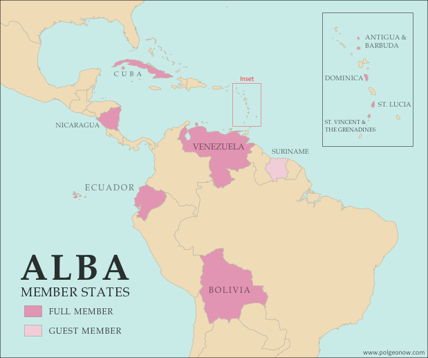
New ALBA Member: Saint Lucia (Map)

Map of the Bolivarian Alliance for the Peoples of Our Americas (ALBA), showing full member countries, including new member Saint Lucia, as well as special guest members (colorblind accessible).
The Bolivarian Alliance for the Peoples of Our Americas (ALBA). Map by Evan Centanni.

Emblem of the Bolivarian Alliance for the Peoples of Our Americas (ALBA)Organization Name:  
• Bolivarian Alliance for the Peoples of Our Americas (English)
• Alianza Bolivariana para los Pueblos de Nuestra América (Spanish)
Launched: 2004 in Havana, Cuba
Headquarters: Caracas, Venezuela
Website: www.alianzabolivariana.org

Article by Evan Centanni

What is ALBA?
The Bolivarian Alliance for the Peoples of Our Americas (ALBA) is an intergovernmental organization open to countries located in the region of the Americas. “Bolivarian” refers to Simón Bolívar, a 19th century leader who founded several South American countries and wanted the whole continent to unite together as a single nation.

ALBA was founded in 2004, as a response to the U.S.’s rejected proposal to create a Free Trade Area of the Americas (FTAA). The FTAA would have extended the North American Free Trade Agreement (NAFTA) – which has lowered trade barriers between the U.S., Canada, and Mexico – to all of South America, Central America, and the Caribbean except for Cuba.

As a counter to the capitalist spirit of the FTAA proposal, Presidents Hugo Chávez of Venezuela and Fidel Castro of Cuba soon agreed to create ALBA, an organization for promoting greater integration among the socialist and social democratic countries of the region.

ALBA plans to eventually introduce a new currency, the SUCRE, which will be shared by the member countries just like how the euro is the shared currency of much of the European Union. Virtual SUCRE currency is already in use for some electronic transfers of money between ALBA member countries.

Past Growth
Although Cuba and Venezuela were originally the only two members of ALBA, the like-minded governments of Bolivia and Nicaragua joined in 2006 and 2007 respectively. Dominica became a member in 2008, followed by Antigua and Barbuda, Ecuador, and Saint Vincent and the Grenadines in 2009. Early last year, the organization admitted Suriname and Saint Lucia as “special guest members,” indicating that they were in the process of achieving full membership. Membership in ALBA is not exclusive – many member countries are also part of other regional blocs such as UNASUR, Mercosur, or the Caribbean Community (CARICOM).

New Member

Flag of Saint Lucia Country Name:  
• Saint Lucia (English)
Sainte-Lucie (French)
Official Name: (same)
Capital: Castries

While Suriname remains a special guest member, Saint Lucia was officially inducted as a full member at the end of this July. Saint Lucia is a small island country in the Caribbean, which was both a British and a French colony at times in the past. The Saint Lucian government’s decision to join ALBA has garnered mixed responses from opposition parties, and becoming part of the anti-imperialist organization is seen by some as a break from the island’s history of close ties with the U.K. There is also debate over the role of the new SUCRE currency in a country that already uses the shared East Caribbean dollar.

Related Articles:
Venezuela Joins Mercosur, Paraguay Suspended
Croatia Joins European Union, Leaves CEFTA
Laos and Tajikistan Join WTO