War in Somalia: Map of Al Shabaab Control (June 2013)

There are newer versions of this map available. To see them, view all Somalia articles on PolGeoNow.

Since the beginning of the year, Somalia’s federal government and its allies have made some major breakthroughs in the war to take back the country from Al Shabaab, Somalia’s local branch of Al Qaeda. This is the third installment in our series of Al Shabaab control maps, marking territorial changes since our last Somalia map update in December 2012.
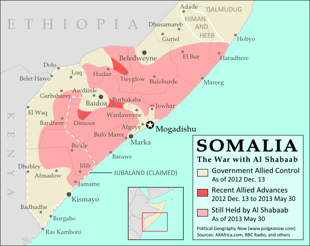
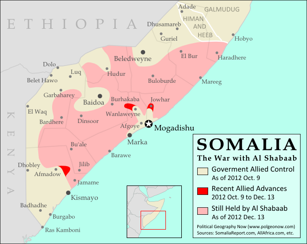
Map of Al Shabaab control in southern Somalia just before June 2013, highlighting recent advances by government and African Union troops since December. Includes the newly recaptured Mogadishu-Baidoa highway corridor, plus Bulo Marer, site of crashed U.S. drone aircraft. Also marks claimed territory of Jubaland state.
Southern Somalia: recent government-allied advances in the war against Al Shabaab. Original map by Evan Centanni. Incorporates elements from this blank map by Eric Gaba and this locator map by TheEmirr. (license: CC BY-SA).

Connecting Mogadishu and Baidoa
After news came in of the Somali Federal Government and its allies completing their control of southern Somalia’s major cities last fall, further progress against the Al Qaeda affiliate group Al Shabaab at first made only slow progress. But since the beginning of this year, at least one major breakthrough has been made.

Background & Actor Profiles: War in Somalia – The Retreat of Al Shabaab 

After several years of being cut off by Al Shabaab, Mogadishu and the key inland city of Baidoa were finally reconnected in February after African Union and Somali forces captured Burhakaba, the last major town lying on the highway between the two cities. As a result, the Al Shabaab’s territory in Somalia has been split into two pieces, though security is probably not so tight that the militants can’t slip back and forth across the narrow band held by the Somali government.
Flag of SomaliaCountry Name:  
Somalia (English)
Soomaaliya (Somali)
• aṣ-Ṣūmāl (Arabic)
Official Name:  
Federal Republic of Somalia (English)
Jamhuuriyadda Federaalka Soomaaliya (Somali)
Jumhūriyyat aṣ-Ṣūmāl al-Fideraaliya (Arabic) 
Capital: Mogadishu

Ethiopian and Somali troops had previously taken the town of Dinsoor, another major town in the region of Baidoa, in mid-December (just after our previous Somalia map update). And fighting in the area continued after the captured of Burhakaba as well, with the Baidoa suburb of Aw Diinle falling to Al Shabaab in March. Although it was reported recaptured soon afterwards, Al Shabaab forces were apparently still present until just a couple weeks ago.

Ethiopian Withdrawal
The town of Hudur north of Baidoa was recaptured by Al Shabaab in March after Ethiopian forces withdrew from the town. Ethiopia soon reported that it would be withdrawing completely from the war in Somalia in the near future.

This is important news, since the Ethiopians have been the major force in the war against Al Shabaab near the Ethiopia-Somalia border for the past year and a half. The African Union Mission in Somalia (AMISOM) has slowly rolled into position to fill the gap, but Ethiopia has still not yet completely withdrawn.

Meanwhile, Somalia’s own army reportedly scored a victory with the capture of Tiyeglow town east of Hudur in May. Hudur itself, however, is apparently still Al Shabaab territory, despite early reports suggesting it was recaptured by Somali forces.

Somalia’s Airspace
The federal government of Somalia announced recently that the country’s airspace will be returning to its control after nearly two decades of U.N. stewardship. However, the northern Somali breakaway state of Somaliland (not shown on this map) has reacted with anger, announcing the seizure of its own airspace from the U.N. in order to preempt the takeover by Mogadishu.

And in other news related to air power, the Somali government and AMISOM last February seized a strategic airfield north of the town of Jowhar, which will help the allies project their power as they push the war ever deeper into Al Shabaab’s remaining territory. The U.S. also has a covert presence in Somalia’s skies and one of its drone aircraft is believed to have crashed this week over the Al Shabaab base of Bulo Marer, not far from the port city of Marka.

Political Struggle for Jubaland
After the capture of Kismayo port by Kenyan forces last September, a political power struggle has emerged in the city. Local groups, backed by Kenya and other neighboring countries, have declared an autonomous area called Jubaland, which claims three of the surrounding administrative regions as a federal state of Somalia.

The central government in Mogadishu, which did not approve the plan, has vigorously opposed Jubaland’s formation, but political conflict and confusion continues in Kismayo, where the leader of the Ras Kamboni militia is now claiming to be the state’s elected president.

Stay Up-to-Date: See past and future updates to this map by filtering for posts about Al Shabaab, or view all Somalia articles.

Related Articles:
Graphic of Somali flag is in the public domain (source).
Nigeria Conflict Map: Assault on Boko Haram

There are newer versions of this map available. To see them, view all Nigeria updates.

Nigeria’s Boko Haram rebels have been active for some years, but it’s only in recent months that they’ve become known to control territory in the country’s far northeast. Now they’re facing a full-on assault from the government after the president declared a state of emergency. Read on for details!

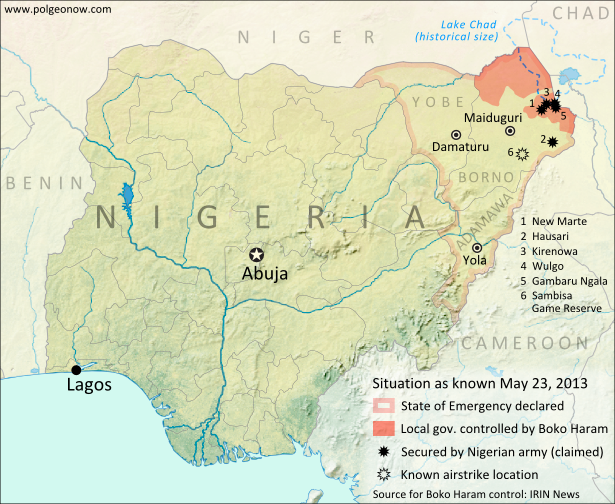
Map of Boko Haram control in northeastern Nigeria, and progress made by the government after declaring a state of emergency and launching a military campaign against the rebels in May 2013.
Boko Haram control and the government intervention in Nigeria’s northeast. Map by Evan Centanni.

Boko Haram Control in Borno State
Nigeria, Africa’s most populous country, has faced regular attacks from the rebels of Boko Haram over the past several years. Operating in the country’s predominantly Muslim north, the fighters claim to seek a purer Islamic society uninfluenced by Western ideas and teaching. While the group’s area of operations stretches across much of northern Nigeria, spilling over into northern Cameroon, until recently Boko Haram was not known for controlling any specific territory.

However, over the past few months there has been more and more talk of areas in Nigeria’s far northeastern Borno State falling under full control of Boko Haram, especially in the area of Lake Chad and the remote border with Cameroon. A report from the U.N.’s IRIN humanitarian news agency lists eight local government areas (similar to counties) in Borno which it says Boko Haram has taken over since January of this year.

Background: What is Boko Haram? A summary and detailed history

Flag of NigeriaCountry Name:  
• Nigeria*
Official Name:  
• Federal Republic of Nigeria*
Capital: Abuja
*There are hundreds of languages spoken in Nigeria, but only English is official.

State of Emergency
Last week, Nigerian President Goodluck Jonathan brought the situation to the world’s attention, announcing that the Boko Haram rebels had wrested control of some areas on the country, and declaring a state of emergency in Nigeria’s three northeasternmost states of Borno, Yobe, and Adamawa. The next day, troops flooded into the region, and a government offensive against the rebels began.

Though details are sparse, fighting since then seems to have focused largely on raiding Boko Haram camps in the central and southern areas of Borno state, leaving the other two states, as well as Borno’s capital, relatively calm. Political Geography Now has not discovered any reports of fighting so far along Borno’s northern border with Niger, despite that being an area claimed by IRIN to be under Boko Haram control.

There have been airstrikes against Boko Haram at various locations which have not been disclosed, though one is reported to be the Sambisa Game Reserve south of Maiduguri, part of a stretch of forest where the rebels are known to have hideouts for avoiding the Nigerian army. By May 17th, government forces had reportedly secured a border crossing with Cameroon at Gambaru Ngala, and this Monday the Nigerian government claimed to have recaptured the towns of New Marte, Hausari, Kirenowa, Wulgo, and Chikun Ngulalo from Boko Haram.*

(*Chikun Ngulalo is not shown on the map above, as we have been unable to locate its position.)

Stay tuned for more updates as new information becomes available. Keep up by checking Political Geography Now homepage, or use the Nigeria filter to view only stories about this country.

Related Articles:

Graphic of the Nigerian flag is in the public domain (source).
Who Recognizes Palestine in 2013?

(Keep up with changes to Palestine’s situation: view all Palestine updates.)

 Palestine is now an Observer State in the U.N., but it’s still not recognized individually by all U.N. member countries. Read on for more about the latest countries to recognize Palestine, plus other recent changes to its international status.

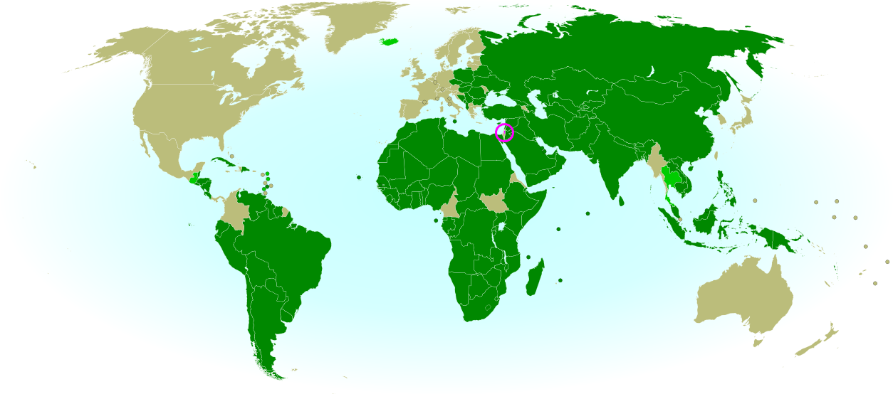
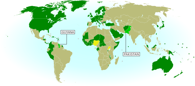
Map of countries that recognize the State of Palestine as an independent country, updated for May 2013 with most recent additions highlighted
Countries recognizing the State of Palestine in green, with most recent additions highlighted in lighter green. Palestine in magenta (circled). Map by Evan Centanni, modified from public domain graphic (source).


By Evan Centanni

Countries that Recognize the State of Palestine
Despite opposition from Israel, the U.S., and other Western countries, Palestine was recognized as an Observer State by the U.N. last year. However, recognition by individual countries is a separate matter. In September of 2011 we reported that the declared State of Palestine had accumulated recognition from 126 U.N. members plus partially-recognized Western Sahara. But have more states recognized Palestine as an independent country since then?

Yes, a few. As highlighted on the map above, several more U.N. member countries have recognized the State of Palestine over the last year and a half. New additions since our previous update are the Caribbean island nations of Dominica, Antigua and Barbuda, and Grenada, plus Thailand in Southeast Asia and Iceland in Europe. The latest, recognizing Palestine for the first time just last month, is the Central American state of Guatemala.

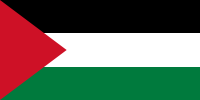
Flag of Palestine Country Name:  
• Palestine (English)
Filasṭīn (Arabic)
Official Name:  
• State of Palestine (English)
• Dawlat Filasṭin (Arabic)
Capital: 
• Jerusalem (claimed)
Ramallah (administrative)

This brings the total number of U.N. members that consider Palestine a sovereign state to 132, or about 68 percent. Or could it be more? Last year, before Guatemala’s announcement, the Palestinian government was already claiming recognition from 132 countries, and the U.N. resolution which made it an Observer State mention that Palestine was already recognized by 132 “members of the United Nations”. However, no additional recognitions have emerged in the months since then, so it seems likely that it was an error. The number 132 probably refers to the 131 U.N. members recognizing at the time, plus Western Sahara.

Wikipedia: List of countries recognizing Palestine

Palestine in UNESCO
Also since our September 2011 report, Palestine was accepted as a member of the United Nations Educational, Scientific and Cultural Organization (UNESCO), a specialized agency of the U.N. This happened before its elevation to Observer State status in the General Assembly, and was quite controversial at the time. It was speculated that becoming an Observer State would increase the likelihood of Palestine being accepted into more U.N. organizations in the future – however, this has not yet happened.

Change of Standard ISO Name
Another change to Palestine’s treatment internationally came with a February 2013 update to the standard list of country codes and names from the International Organization for Standardization (ISO). This standard, which is used by many organizations and companies around the world, is tied to official United Nations usage. After the Palestinian government received Observer State status from the U.N., its name was changed in the standard from “the Occupied Palestinian Territory” to “the State of Palestine”.

Online company Google caused a bit of a stir last week when it changed the name of its Palestinian search page from “Palestinian Territories” to “Palestine”, receiving criticism from the Israeli government. However, Google argued that it was not making a political statement, but only following the lead of the U.N. and the standard used by websites around the world.

Check For Updates: See more recent recognition reports by viewing all Palestine posts.

Related Articles:

Is Palestine Really a Country?

Mali Conflict Map: Hardline Rebels on the Run, Separatists Rebounding (May 2013)

There are newer versions of this map available. To see them, view all Mali maps.  

This is an update within our Mali conflict map series – for the original story, see Mali Map: Islamist Control & French Intervention.

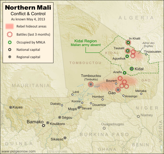
Updated map of fighting and territorial control in Mali during the 2013 French and African intervention against Islamist rebel groups MUJAO, Ansar Dine, and Al Qaeda in the Islamic Maghreb (AQIM). Reflects the situation as of May 4, 2013, including areas occupied by Tuareg rebels of the National Movement for the Liberation of Azawad (MNLA).
Updated map of territorial control and fighting in Mali, as of May 4, 2013. Map by Evan Centanni, modified from Wikimedia map by Orionist, using images by Carport and NordNordWest (source). License: CC BY-SA.

Towns Cleared of Islamist Rebels
Since our last Mali update in February, the country’s religious extremist rebel groups have continued their retreat from the northern cities that they controlled for half a year. The military intervention by France and Mali’s neighbors has somewhat reunited the country, though with some important exceptions.

In Mali’s far northeast, French and Chadian forces have driven Ansar Dine and Al Qaeda in the Islamic Maghreb (AQIM) out of the important towns of Aguelhok and Tessalit, afterwards seeing heavy combat in the nearby mountains of the Adrar des Ifoghas, where Chad claims to have killed two key regional Al Qaeda leaders. Though many rebels are said to have fled the country, some are still holed up deep in the mountains, and have launched terrorist attacks on the regional capital of Kidal.

More information: Regular situation reports from the French army (in French)

Northern Mali’s biggest city, Gao, was secured by French forces early in the intervention, and is now patrolled by troops from Mali and other African countries. However, the Al Qaeda-offshoot rebels of the Movement for Unity and Jihad in West Africa (MUJAO), who ruled the city for months, have continued their resistance, initiating two major battles in Gao during February, and another in March. Timbuktu has faced similar attacks, which have been variously attributed to either MUJAO or AQIM.

Flag of MaliCountry Name:  
• Mali (English, French, Bambara)
Official Name:  
• Republic of Mali (English)
• République du Mali (French) 
• Mali ka Fasojamana (Bambara)
Capital: Bamako

MUJAO fighters are now based in the villages and countryside surrounding Gao, especially just across the River Niger and in the valleys to the northeast, where French soldiers have been involved in lethal confrontations with the militants. The stretch of the River Niger between Gao and Timbuktu has also seen MUJAO activity, but at least one major town along the route, Bourem, has been secured by the allied forces.

Photos: Mali Conflict Enters New Phase (The Atlantic)

Kidal, Azawad, and the MNLA
The National Movement for the Liberation of Azawad (MNLA), a secular rebel organization made up mostly of people from the Tuareg ethnic group, has sprung back to life in Mali’s far northeast. It now occupies most of the Kidal region, including the capital and key towns, cooperating with the French and Chadian armies but forbidding Malian troops from entering.

The group, which initiated the rebellion in northern Mali last year – declaring an independent country called “Azawad” before being pushed out by Ansar Dine and MUJAO – now seeks again to negotiate with the Malian government. It has ceased its explicit calls for independence, even saying it “recognizes the borders” of Mali, though it has since begun issuing official “Republic of Azawad” documents to drivers passing through Mali’s far northeast.

This second rise of the MNLA was made possible by concerns that Malian soldiers were abusing, and in some cases murdering, Tuareg civilians in the cities they had retaken. Kidal, unlike Gao and Timbuktu, actually has a Tuareg majority, and the MNLA is relatively popular there. After the extremist Ansar Dine rebels fled from Kidal ahead of the French advance, the MNLA welcomed the foreign troops, cooperating with the soldiers from France and Chad. The Malian army, apparently sensing it’s not welcome, has mostly not entered the region.

The MNLA now operates a checkpoint in Anefis, on the border of Kidal and Gao regions, and has defended itself against other rebel groups in the surrounding desert as well as in the town of In Khalil on the border of Mali and Algeria. In February, the MNLA also claimed control of Menaka in Gao region, but the town is now known to be under the control of African troops from neighboring Niger.

Northern Mali: Looking Forward
The future is not at all certain for Mali’s north, with Islamist militants still active and the MNLA calling for greater autonomy against the wishes of the Malian government. Deepening the uncertainty, France and Chad, by far the two strongest armies currently in Mali, are both beginning to withdraw their forces, not wanting to become stuck in an ongoing guerrilla war. However, there’s still hope for Mali not to descend back into chaos; the U.N. security council has authorized a peacekeeping mission to take over starting from July, which will work under the name Multidimensional Integrated Stabilization Mission in Mali (MINUSMA).

Related Articles:

Central African Republic: Map of Rebel Advance to Capital

Graphic of Malian flag is in the public domain (source).