Syrian Civil War Map & Timeline: Siege of Deir ez-Zor Broken – September 2017 (Subscription)

SUBSCRIBERS CLICK HERE TO PROCEED TO ARTICLE AND MAP

There are newer versions of this map available. To see them, view all Syria updates.

Research by Djordje Djukic. Map by onestopmap.com, Evan Centanni, and Djordje Djukic

Subscribe for full access to all conflict map reports!


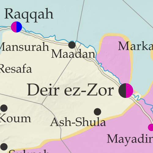
Map of Syrian Civil War (Syria control map): Fighting and territorial control in Syria in September 2017 (Free Syrian Army rebels, Kurdish YPG, Syrian Democratic Forces (SDF), Jabhat Fateh al-Sham / Hayat Tahrir al-Sham (Al-Nusra Front), Islamic State (ISIS/ISIL), and others). Includes Russia-Turkey-Iran agreed de-escalation zones and US deconfliction zone, plus recent locations of conflict and territorial control changes, such as Deir ez-Zor, Maadan, As Suwar, Aqerabat, and more. Colorblind accessible. In the past month, the territory of the so-called “Islamic State” (IS; formerly ISIS/ISIL) has continued to shrink rapidly, with the Russia-backed Assad government and the US-backed Syrian Democratic Forces (SDF) both rushing to secure Deir ez-Zor province in Syria’s east.

See all this and more on the latest update to PolGeoNow’s concise, professional Syrian Civil War control map, which includes a timeline of changes since our previous Syria map report in August, with sources cited.

This map and report are premium content, available to paid subscribers of the PolGeoNow Conflict Mapping Service.

Want to see before you subscribe? Check out our most recent FREE SAMPLE Syria map!

Exclusive map report includes:

  • Up-to-date illustration of current territorial control in Syria, color-coded for the Assad government, rebel groups, “Islamic State” (ISIS/ISIL) fighters, and Kurdish/SDF forces. Colorblind accessible.
  • Markers showing the approximate locations of Russian-Turkish-Iranian “de-escalation zones” and the one known US “deconfliction zone”.
  • Special symbols indicating towns dominated by rebels of the former Al Qaeda Nusra Front (now Hayat Tahrir al-Sham) and US-backed Syrian Democratic Forces (SDF).
  • Detailed indication of city-by-city control, including key towns and other locations important to current events.
  • Locations of recent fighting and other important events, including Deir ez-Zor, Maadan, As Suwar, Aqerabat, and more.
  • Detailed timeline of important events and changes to territorial control since August 28, 2017, compiled by our Syria-Iraq expert, with links to sources.

SUBSCRIBERS CLICK HERE TO PROCEED TO ARTICLE AND MAP

Not signed up yet? Click here to learn more about our professional subscription service!

Can I purchase just this map?
This map and report are not available for automated purchase to non-subscribers. If you need access or republication rights for only this map report, contact service@polgeonow.com for options.

Syrian Civil War Map & Timeline – August 2017 (Subscription)

SUBSCRIBERS CLICK HERE TO PROCEED TO ARTICLE AND MAP

There are newer versions of this map available. To see them, view all Syria updates.

Research by Djordje Djukic. Map by onestopmap.com, Evan Centanni, and Djordje Djukic

Subscribe for full access to all conflict map reports!


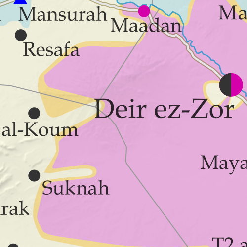
Map of Syrian Civil War (Syria control map): Fighting and territorial control in Syria in August 2017 (Free Syrian Army rebels, Kurdish YPG, Syrian Democratic Forces (SDF), Jabhat Fateh al-Sham / Hayat Tahrir al-Sham (Al-Nusra Front), Islamic State (ISIS/ISIL), and others). Includes Russia-Turkey-Iran agreed de-escalation zones and US deconfliction zone, plus recent locations of conflict and territorial control changes, such as Raqqah, Maadan, Suknah, al-Koum, and more. Colorblind accessible.In the past month, the so-called “Islamic State” (ISIS/ISIL) has lost vast swaths of territory in the center of Syria to government forces, leaving the western end of its main territory completely surrounded. Meanwhile, Syrian and Lebanese forces have cleared out ISIS and hardline rebel forces who controlled areas along both sides of the border with Lebanon.

See all this and more on the latest update to PolGeoNow’s concise, professional Syrian Civil War control map, which includes a timeline of changes since our previous Syria map report in July, with sources cited.

This map and report are premium content, available to paid subscribers of the PolGeoNow Conflict Mapping Service.

Want to see before you subscribe? Check out our most recent FREE SAMPLE Syria map!

Exclusive map report includes:

  • Up-to-date illustration of current territorial control in Syria, color-coded for the Assad government, rebel groups, “Islamic State” (ISIS/ISIL) fighters, and Kurdish/SDF forces. Colorblind accessible.
  • Markers showing the approximate locations of Russian-Turkish-Iranian “de-escalation zones” and the one known US “deconfliction zone”.
  • Special symbols indicating towns dominated by rebels of the former Nusra Front (now Hayat Tahrir al-Sham) and US-backed Syrian Democratic Forces (SDF).
  • Detailed indication of city-by-city control, including key towns and other locations important to current events.
  • Locations of recent fighting and other important events, including Raqqah, Maadan, Suknah, al-Koum, and more.
  • Detailed timeline of important events and changes to territorial control since July 21, 2017, compiled by our Syria-Iraq expert, with links to sources.

SUBSCRIBERS CLICK HERE TO PROCEED TO ARTICLE AND MAP

Not signed up yet? Click here to learn more about our professional subscription service!

Can I purchase just this map?
This map and report are not available for automated purchase to non-subscribers. If you need access or republication rights for only this map report, contact service@polgeonow.com for options.

Syria Civil War Map: August 2014 (#13)

There are newer versions of this map available. To see them, view all Syria updates.

Premium subscribers have already seen our new Syria map format, which shows full areas of control for each major faction in the civil war. Now, we present this month’s update free of charge for your convenience. 

To get many more Syrian Civil War map updates like this one, sign up now for a premium subscription!

Map of fighting and territorial control in Syria's Civil War (Free Syrian Army rebels, Kurdish groups, Al-Nusra Front, Islamic State (ISIS/ISIL) and others), updated for August 2014. Highlights recent locations of conflict and territorial control changes.
Territorial control in the Syrian Civil War as of August 2014. Map by Evan Centanni, starting from blank map by NordNordWest. License: CC BY-SA

Premium members click here to view this article in the ad-free members area.

Threats from All Sides
Since our last Syria map update in early July, the lines of control in the civil war have not changed drastically. However, fighting on all fronts has resulted in numerous small but important changes to the situation, as the Assad government is now facing serious challenges from both the newly rebranded Islamic State (formerly ISIS/ISIL) and a loose coalition of various other rebel groups (including both the Free Syrian Army and Al-Nusra).

Rebel Advances
Opposition forces made advances against the army in two parts of Hama province over the past month, beginning in mid-July with their capture of Rahjan in the province’s east. Before the end of the month, they had also advanced nearly to the city of Hama, by some accounts fully capturing Khitab and nearby towns. In early August, major fighting erupted in Arsal, a town across the border in Lebanon. Rebels recently driven out of nearby Syrian areas struggled with the Lebanese army over several days before eventually retreating.
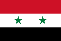
Flag of Syria under the current governmentCountry Name:  
• Syria (English)
• Sūriyya/Sūryā (Arabic)
Official Name:  
• Syrian Arab Republic (English)
• al-Jumhūriyyah al-‘Arabīyah  as-Sūriyyah (Arabic)
Capital: Damascus

Rebel Setbacks
However, signs of a rift among the rebel coalition may be emerging. Similarly to how ISIS began carving out its own territory late last year, the rebel Al-Nusra Front last month declared its own “emirate” and seized the northwestern towns of Salqin, Harem, and Darkush from formerly allied rebel groups. The powerful Al-Nusra Front is an official affiliate of Al Qaeda, but has up to now cooperated and mixed freely with less extreme anti-government rebels. It remains to be seen whether recent events signal a permanent split.

The rebels, including Al-Nusra, have also suffered some defeats. Formerly the major power in Syria’s eastern Deir ez-Zor province, they have now been completely driven out, with the Islamic State last month replacing them in Deir ez-Zor city and driving them out of their last territories to the city’s northwest (the Islamic State’s main campaign for Deir ez-Zor province was covered in last month’s update).

Within Syria’s largest city of Aleppo, rebel fighters also were driven back from some of their positions by an early-July government advance.

Consolidating the “Caliphate”
Above all, the past month has seen a strengthening of the “Islamic State” group, formerly known as the Islamic State of Iraq and al-Sham (ISIS). After seizing much of neighboring Iraq in June, ISIS declared itself to be the Caliphate, a historical term for an empire of all Muslims, and shortened its name to “Islamic State”. Controlling the major Iraqi city of Mosul, it has used this newfound power to consolidate its territories in both countries.

Map of the Islamic State's control in Iraq as of August 2014
The Islamic State’s control in Iraq (click for premium article and map).

In Syria, the Islamic State has nearly completed its control of Raqqah province. Though it already held the capital, three key military bases in the province were still controlled by the Assad government. Two of those, known as Division 17 and Brigade 93, were seized by the Islamic State earlier this month, while the last, Tabqa Airbase, is now under siege. In neighboring Hasakah province, Islamic State fighters also captured a key government base, the 121st Artillery Regiment, even waging battles on the outskirts of Hasakah city and advancing nearly to Qamishli on the Turkish border. However, government forces also scored some victories, maintaining joint control of the city with Kurdish forces and at one point pushing the militants back towards their stronghold in Shadadi.

Islamic State Advances West
The Islamic State has also begun striking out west from its current territories in both the north and the south. In Aleppo province it has been very slowly taking back ground it lost to the rebel coalition in January, seizing the town of Akhtarin just last week. Meanwhile, it has also been pushing against the Kurdish enclave of Kobane (Ayn al-Arab) from both sides. More prominently, Islamic State forces last month boldly stormed the Sha’er gas field near Palmya, far from their established frontiers, though the government soon recaptured it.

But pockets of Islamic State control have been appearing even farther afield, possibly in connection with the group’s efforts to bring small rebel brigades over to its side. Some reports say the town of Deir Ful near Homs city is now in Islamic State hands, and the group briefly captured a neighborhood outside Damascus last month.

Don’t miss future updates to the Syria and Iraq control maps! Become a member now!

Graphic of the Syrian flag is in the public domain (source).

Syria Civil War: Territorial Control Map #12.3 (Premium)

There are newer versions of this map available. To see them, view all Syria updates.

Detailed map of fighting and territorial control in Syria's Civil War (Free Syrian Army and Nusra Front rebels, Kurdish groups, ISIS/ISIL/Islamic State and others), updated to July 3, 2014.

Download PDF
buy

(Subscribe via Paypal to view all premium content online)

This is the Syria update you’ve been waiting for: our new map includes not only cities, but a full illustration of territorial control for each faction in the civil war. Also includes many updates to the situation since the last edition in April.

This map and article are exclusive premium content, available to paid subscribers or for individual purchase.
Buy now (US$9.99)

Premium map includes:

  • Up-to-date map of current territorial control in Syria, color-coded for the Assad government, rebel groups, ISIS/Islamic State extremists, and Kurdish self-protection forces
  • Detailed indication of city-by-city control, highlighting key towns relevant to current events
  • Includes recent areas of fighting including Deir ez-Zor, Abu Kamal, Mayadin, Khan Shaykhun, and many more
  • In-depth article summarizes changes since April, including ISIS’s declaration of an Islamic caliphate, with links to the sources of information

Members click here to proceed to article and map

Not a member yet? Subscribe Now!

Syria Civil War Map: June 2013 (#10)

There are newer versions of this map available. To see them, view all Syria updates.

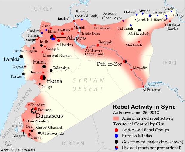
Since March, large-scale violence has continued in Syria. Despite this, no major cities have changed hands – yet there have been important changes to control of smaller towns in two different regions. Here’s the updated conflict map, plus a summary of recent territorial changes.

Map of rebel activity and control in Syria's Civil War (Free Syrian Army, Kurdish groups, Al-Nusra Front and others), updated for June 2013. Includes recent locations of conflict and violence, including the Qusayr, Golan Heights, Daraa, Dael, and Baida.
Activity and cities held by rebels and other groups in Syria, updated for June 2013. Map by Evan Centanni, starting from this blank map by German Wikipedia user NordNordWest. License: CC BY-SA

Golan Heights Fighting
Soon after our last update, rebel groups continued making small gains in Syria’s far southeast. In mid-March, they captured a military intelligence compound in the town of Shagara, and three days later the same group seized the town of Khan Arnabeh a bit to the north. Both towns lie close to the Golan Heights, a disputed territory controlled by Israel.

A narrow strip of land on the Syrian side of the Golan Heights ceasefire line has been demilitarized under the protection of U.N. peacekeepers since 1973, but even this area has seen fighting since late last year. Rebels in the zone briefly took control of the border crossing with Israel early this month, part of a series of events that has put the peacekeeping mission’s future in jeopardy.

Rebel Gains in Daraa
Soon after taking Khan Arnabeh, the same rebel group achieved yet another major victory: the capture of a major air defense base just east of the southern Syrian city of Daraa. Soon they and other rebel groups had effective control of all border crossings with Jordan.

By the end of the month, rebel forces were also in control of Dael, an important town north of Daraa city. It was only in May that the Syrian army began getting its foothold back outside of Daraa, seizing the town of Khirbet Gazaleh near Dael.

Flag of Syria under the current governmentCountry Name:  
• Syria (English)
• Sūriyya/Sūryā (Arabic)
Official Name:  
• Syrian Arab Republic (English)
• al-Jumhūriyyah al-‘Arabīyah  as-Sūriyyah (Arabic)
Capital: Damascus

Government Takes Qusayr
The more important change in control came early this month, when the Syrian government and allied forces captured Qusayr after a long and difficult battle. Qusayr is a strategic town between the city of Homs and the border with Lebanon, and saw prolonged fighting earlier in the war before coming under rebel control a year ago. Since Qusayr’s recapture, other nearby towns have also been seized by the government.

Hezbollah and Lebanon
In the battle for Qusayr, Syria’s army received major military support from Hezbollah, a Shiite militia from Lebanon which has long supported President Bashar al-Assad. After that victory, Hezbollah has become more overtly involved in the fighting within Syria. Meanwhile, Lebanon is being slowly dragged into its neighbor’s civil war, with one Lebanese town even coming under attack from the Syrian military two weeks ago.

Battles Continue in Major Cities
Syria’s biggest population centers continue to be centers of intense fighting as well, with Aleppo still divided between multiple groups (see a collaborative map of control) and once-rebel-dominated Homs now reportedly 80% government-controlled. At the same time, the capital city of Damascus continues to see heavy back and forth fighting in its suburbs, and in recent months rebels have even begun moving into the city itself.

Activity on the Coast
Last month, the town of Bayda near Syria’s Mediterranean coast became infamous for a brutal massacre committed by government or allied forces against Sunni civilians, some of whom had been rebel sympathizers (rebels were also accused of a sectarian massacre in a few weeks later). The Bayda massacre was reportedly a response to an attack by local rebels on a bus carrying pro-government militiamen, a rare and possibly unprecedented instance of armed rebel activity Syria’s coastal region. This area, which is the traditional homeland of President Assad’s minority Alawite sect, has been so far spared from rebel-on-army fighting, though it has been the scene of unarmed protests violently suppressed by the government.

Adjustments to the Map
Two adjustments have been made to the Syria control map in this update which do not necessarily reflect actual changes to the situation since last time. First, the city of Hama has been colored all black rather than black and red, to reflect the fact that there has recently been little evidence of significant rebel control within the city (however, back-and-forth fighting continues outside the city in Hama province).

The second adjustment is to Zabadani, in the mountains between Damascus and the border with Lebanon. This town has been contested since early in the war, sometimes falling under rebel control and other times to the government. The most recent information suggests that rebels have nearly complete control of the town itself, despite being surrounded by government forces.

Related Articles:

Graphic of the Syrian flag is in the public domain (source).