Iraq Control Map & Timeline – February 2018 (Subscription)

SUBSCRIBERS CLICK HERE TO PROCEED TO ARTICLE AND MAP

(To see other maps in this series, view all Iraq updates.)

Research by Djordje Djukic. Map by onestopmap.com, Evan Centanni, and Djordje Djukic

Subscribe for full access to all conflict map reports!


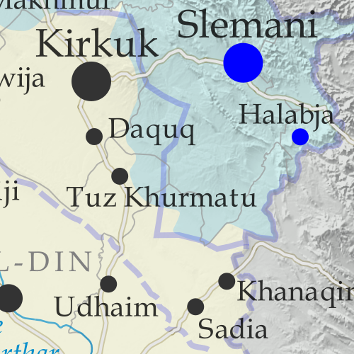
Detailed map of territorial control in Iraq as of February 22, 2018. Shows territory held by the so-called Islamic State (ISIS, ISIL), the Baghdad government, the Kurdistan Peshmerga, and the Yezidi Sinjar Alliance (YBS and YJE). Colorblind accessible.
Since November, pro-government forces in Iraq have nearly, but not entirely, cleared the country of control by the so-called “Islamic State” (ISIS/ISIL), with the group still reportedly holding out in parts of the western desert.

See all this and more on the latest update to PolGeoNow’s concise, professional map of control in Iraq’s civil war, including a timeline of changes since our previous Iraq map report of November 2017.

This map and report are premium content, available to paid subscribers of the PolGeoNow Conflict Mapping Service.

Want to see before you subscribe? Check out our most recent FREE SAMPLE Iraq map report!

Exclusive report includes:

  • Up-to-date map of current territorial control in Iraq, color-coded for the Iraqi government, “Islamic State” (ISIS/ISIL) fighters, Kurdistan’s Peshmerga forces, and Yezidi militias. Colorblind accessible.
  • Detailed indication of town-by-town control, including all major cities and many smaller ones, as well as terrain, major roads, and provincial boundaries
  • Timeline of changes to the situation since the end of November, compiled by our Iraq-Syria specialist, with links to sources.

SUBSCRIBERS CLICK HERE TO PROCEED TO ARTICLE AND MAP

Not signed up yet? Click here to learn more about our professional subscription service!

Can I purchase just this map?
This map and report are not available for automated purchase to non-subscribers. If you need access or republication rights for only this map report, contact service@polgeonow.com for options.

Syrian Civil War Map & Timeline – February 2018

There are newer versions of this map available. To see them, view all Syria updates.

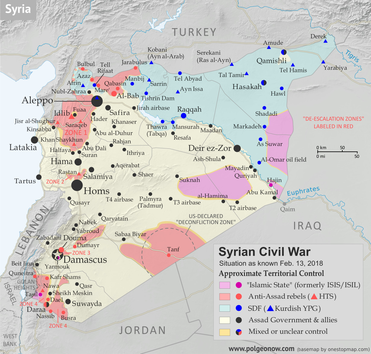
Who controls what in Syria? Rebel and ISIS control map of the Syrian Civil War. Shows territorial control as of February 2018 (Free Syrian Army rebels, Kurdish YPG, Syrian Democratic Forces (SDF), Jabhat Fateh al-Sham / Hayat Tahrir al-Sham (Al-Nusra Front), Islamic State (ISIS/ISIL), and others). Includes Russia-Turkey-Iran agreed de-escalation zones and US deconfliction zone, plus recent locations of conflict and territorial control changes, such as Abu al-Duhur, Bulbul, Saraqeb, and more. Colorblind accessible.
Base map by Koen Adams of onestopmap.com, with territorial control by Evan Centanni and Djordje Djukic.
Contact us for permission to use this map.

(Subscribers click here to view this article on the member site)

Timeline by Djordje Djukic

Situation Summary

The past few weeks since our previous Syria map update have been dominated by news from two main arenas of battle, both in the country’s northwest. In the most politically significant development, the Turkish military has entered the Kurdish-administrated Afrin region (also spelled “Efrin”) as part of a mission, alongside allied rebel fighters, to drive Kurdish militias out of the western border region. Meanwhile, forces loyal to Syria’s Assad government have made major advances in areas south of Aleppo, eliminating an enclave of the so-called “Islamic State” (IS; formerly ISIS/ISIL) and cutting into rebel control around the edges of Idlib province.

The main boundary-related milestones in this update involve the former side-by-side rebel and IS exclaves at the corner of Idlib, Aleppo, and Hama provinces, which were together already encircled by pro-government troops as of our January report. Since that was published, IS forces managed to take over the rebel-held parts of the pocket, simultaneously eliminating the rebel exclave, erasing one of only two IS borders with Syrian rebel territory, and making the IS territory into a proper enclave, fully surrounded by government forces. Not long afterwards, the IS enclave was itself eliminated by government forces, though a smaller, short-lived pocket of IS control briefly sprung up farther to the west.

Turkey’s incursion into the Afrin region has also created three or four new exclaves of rebel control wedged between the Kurdish-administered area and the Turkish border. However, because of the heavy involvement of Turkish troops, some observers might consider these mere extensions of Turkish territory. If the Turkish-led forces are able to continue their advance, we may also soon see the elimination of Kurdish Afrin’s border with Turkey.

See Also: Iraq Control Map for February 2018

Flag of Syria under the current governmentCountry Name:  
• Syria (English)
• Sūriyya/Sūryā (Arabic)
Official Name:  
• Syrian Arab Republic (English)
• al-Jumhūriyyah al-‘Arabīyah  as-Sūriyyah (Arabic)
Capital: Damascus

Note: Red triangles on the map represent towns where rebel group Hayat Tahrir al-Sham (HTS) – formerly known as Al Qaeda affiliate Jabhat al-Nusra (a.k.a. the Nusra Front), and later Jabhat Fateh al-Sham (JFS) – is thought to be in a dominant position among rebel forces, even if it doesn’t exercise exclusive control. This organization has at least some presence in most rebel-held areas of Syria.

Timeline of Events
The following is a timeline of changes to territorial control and other key events in Syria since our previous map update of January 20, 2018. Sources are provided as in-line links.

January 21, 2018
Turkey-supported Free Syrian Army (TFSA) rebels pushed into the Kurdish-administered Afrin region and captured four to nine villages. Later, the Kurdish-led Syrian Democratic Forces (SDF) recaptured two villages. Turkish military forces were fighting alongside the rebels, on a mission to establish a buffer zone between the border and the territory of the SDF, whose dominant Kurdish YPG militia Turkey considers to be terrorists because of links to rebels inside Turkey. (The Turkish government hopes to eventually create a Turkey-friendly buffer zone along Syria’s entire northern border.)

Meanwhile, the Syrian military continued its clean-up operations around the Abu al-Duhur airbase, while also attempting to capture the town of Abu al-Duhur itself, and was also advancing against a besieged rebel-controlled pocket at the intersection of Idlib, Hama and Aleppo provinces. In addition, the army captured two villages from IS in the group’s adjacent enclave. Later, the Syrian Ministry of Defense reported that the airbase had been secured.

January 22, 2018
Government forces seized Abu al-Duhur, and the number of villages captured by the military over the previous 12 hours in the Idlib-Hama-Aleppo pocket reached 30. Meanwhile, the TFSA captured a strategic mountain in the northeast of the Afrin region, as well as a hill to the north. However, the SDF later recaptured the mountain.

January 22-23, 2018
A two-day rebel attack on government positions in Latakia province was repelled, but 16 soldiers were killed during the attack.

January 23, 2018
The TFSA launched a new assault on a strategic mountain in the Afrin region, before Kurdish forces pushed it back. The mountain overlooks the eastern approach to Afrin city. Meanwhile, government forces captured a village west of Abu al-Duhur.

January 24, 2018
IS captured the remaining 17 villages in the government-besieged Idlib-Hama-Aleppo pocket from HTS rebels. Government forces also seized several villages in the enclave from HTS.

January 25, 2018
IS forces launched an assault across the Euphrates River, attacking the government-held western bank. The attack was eventually repelled. Between 18 and 25 IS fighters, as well as between a dozen and 26 pro-government fighters, were killed during the attack along a 32 kilometer front.

January 26, 2018
The town of Abu al-Duhur was reported to once again be contested between government and HTS forces. Meanwhile, the SDF recaptured a village in the Afrin region from pro-Turkish forces.

January 28, 2018
Pro-Turkish forces captured the strategic mountain in the Afrin region that they had been targeting for the past several days.

January 29, 2018
The army captured Abu al-Duhur, thus securing the western flank of the nearby airbase. Three other nearby villages were also captured. Meanwhile, the SDF captured an IS stronghold on the eastern bank of the Euphrates, about 15 km northwest of Hajin, for the fourth time following five weeks of back-and-forth fighting.

January 30, 2018
A civilian was killed when a Turkish military convoy was attacked by a car bomb in the Idlib countryside. A soldier and another civilian were wounded. The Turkish military stated that the convoy had been traveling as part of its mission to enforce a “de-escalation” zone in the province. According to pro-government sources, the convoy was attempting to block further Syrian Army advances in the Aleppo countryside, but that after the attack it had quickly returned to the border.

January 31-February 1, 2018
Government forces seized 100 square kilometers of territory, including 20 villages, in the eastern countryside of Idlib and the southern countryside of Aleppo, coming within 14 kilometers of Saraqeb, a major town at the junction of two key highways.

February 1, 2018
It was reported that since the start of the offensive against Afrin, pro-Turkish forces had advanced only seven kilometers and seized between 15 and 20 villages, about 4 percent of the total number in the region. Meanwhile, Syrian government troops launched an assault against the IS enclave in the northeastern countryside of Hama, capturing three villages and a hill.

February 1-3, 2018
On February 1, the TFSA reached Bulbul, 30 kilometers north of Afrin, and soon afterwards Turkish media claimed the pro-Turkish forces had captured the town. However, pro-opposition and Kurdish sources said the town was still contested. Two days later, the TFSA capture of Bulbul was confirmed.

February 2-3, 2018
Government forces advanced farther toward Saraqeb after capturing four more villages. The next day, the army reportedly seized one more village on the provincial border of of Idlib and Aleppo, as well as one in the southwestern countryside of Aleppo.

February 3, 2018
HTS rebel fighters shot down a Russian Sukhoi 25SM fighter jet over Idlib province with a shoulder-launched anti-aircraft MANPAD missile. It was the first case of a Russian jet being brought down by the rebels since the start of the Russian intervention in the civil war in 2015. The pilot ejected and was immediately fired upon by HTS fighters. He managed to land on the ground and returned fire, shooting two rebels, before he killed himself by detonating a grenade to avoid capture.

February 3-7, 2018
The army continued with an armored assault from multiple directions against the IS pocket in northeastern Hama province, taking control of up to 30 villages, reportedly representing 80 percent of the pocket.

February 5-7, 2018
The rebels launched a counterattack against government forces in the eastern countryside of Idlib, recapturing one village and advancing into a second. Two days later, two more villages were recaptured by the rebels, though it was later reported that one of them had once again come under army control.

February 8, 2018
The US reported that a force of about 500 pro-Syrian government soldiers, supported by artillery, tanks, multiple-launch rocket systems, and mortars, attacked the SDF and American military advisors east of the Euphrates River in Deir ez-Zor province. Coalition airstrikes were then launched against the pro-government forces, with the US claiming more than 100 pro-government fighters were killed, while only one SDF combatant was wounded during the fighting. In contrast, pro-opposition activists reported that 45 pro-government fighters were killed in the airstrikes, while Syrian military sources stated that 45 Syrian soldiers were killed.

Days later, reports emerged that Russian private military contractors (PMCs) supporting the pro-government forces had also died in coalition counterattack, with between 5 and 10 PMC deaths confirmed.

Meanwhile, the Syrian army renewed its attack against the encircled IS pocket in the northeast of Hama, reducing it to about a dozen towns and villages, while the majority of IS forces withdrew to just one town.

February 9, 2018
After one week of fighting, government forces cleared the whole IS enclave in the northeastern countryside of Hama, taking control of 80 villages and fully securing a key highway linking Hama and Aleppo. Opposition activists said that a corridor was opened by the government for the remaining 200 IS fighters to retreat towards rebel-held territory in Idlib province, with IS subsequently capturing three villages from the rebels. According to pro-government sources, the IS forces had instead conducted a surprise break-out towards rebel territory, advancing through over a dozen government-held villages before reaching it.

Meanwhile, the strip of territory that Turkey-backed forces had seized from the SDF along the border was estimated to have reached 15 kilometers in width.

February 10, 2018
An Israeli F-16 fighter jet crashed after coming under fire from Syrian anti-aircraft missiles during a raid against Iranian facilities in eastern Homs province that had earlier launched a drone into Israel. The drone had been intercepted and shot down by Israel. The F-16 crashed in northern Israel, with both pilots ejecting and then being evacuated to a hospital. Subsequently, Israel conducted a second raid against 12 Syrian and Iranian military targets southwest of Damascus. Later in the day, Israel also conducted a third raid near Damascus. Overall, six pro-government fighters, including non-Syrians, were reported killed in the airstrikes.

Meanwhile, a Turkish military attack helicopter was shot down by Kurdish forces in the Afrin region, with both crew members killed. During the day’s fighting in Afrin, the TFSA managed to make advances, linking up with rebel forces in Idlib province.

February 11, 2018
The TFSA advanced to within three kilometers of a strategic town in the Afrin region.

February 12, 2018
IS captured two villages from rebels in the southeastern Idlib countryside and was fighting for control of a third village. Elsewhere, the SDF captured one village from IS on the eastern bank of the Euphrates River, after which IS launched a counterattack in an attempt to retake it. Meanwhile, the TFSA managed to establish a buffer zone around its recent gains in the southern part of Afrin, while in the northern part a new TFSA attack was repelled by the YPG.

February 13, 2018
Four hundred IS fighters and their family members surrendered to rebels in the area they had captured the previous day in Idlib province. The IS fighters also gave up all of their positions in the area. Meanwhile, more advances by the TFSA brought a total of 8 percent of the Afrin region under its control. Overall, since the start of the Turkish-led operation in the area, between 453 and 456 people had been confirmed killed, including 177 TFSA and 163 SDF fighters, 75 civilians in Syria, 7 civilians in Turkey, and 31-34 Turkish soldiers.

Graphic of the Syrian flag is in the public domain (source).

Parade of Nations: Which Countries Are (and Aren’t) in the Olympics? (PyeongChang 2018)

This is an updated version of an article first published in 2012. You can also read the London 2012, Sochi 2014, and Rio 2016 versions.

World map showing the five continental associations of National Olympic Committees, including all nations eligible for the PyeongChang 2018 Olympic Games.
Map of all countries in the Olympics and their regional associations. By Evan Centanni, modeled after this map.

The 2018 Winter Olympics in Pyeongchang County, South Korea officially open tomorrow, February 9th! They’ll be the second Olympics to be hosted in South Korea, after the 1988 Summer Games. These are also only the thirdever Winter Olympics to be held outside of Europe and North America, following up the 1972 and 1998 games hosted by Japan.

Of course, it wouldn’t be an Olympic opening ceremony without the Parade of Nations. But how many countries are there in the games, and is everyone included? Read on for PolGeoNow’s updated guide to the roster of Olympic Nations…

How many countries are in the Olympics?

There are currently 206 recognized Olympic Nations, represented by a National Olympic Committee (NOC) in each country. The International Olympic Committee (IOC) presides over the Olympic Games themselves, and the NOCs are divided between five continental associations (see map above).[1]

If 206 countries sounds like too many, don’t worryyou’re not going crazy. The UN only recognizes 195 countries worldwide (See: How Many Countries Are There in the World?). So what gives? Well, it turns out the IOC used to be more relaxed than the UN about requirements for nationhood…

Dependent territories that are Olympic Nations

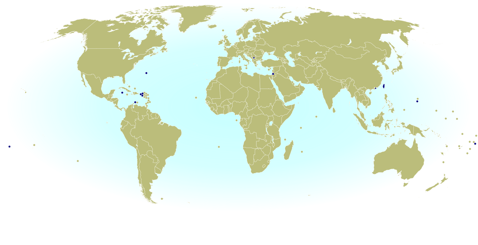
Before 1995, countries’ overseas territories and other dependencies were allowed to qualify for the Olympics on their own, since many are self-governing and technically not “part of” the countries they belong to. The ones that got approved before the rules changed have been grandfathered in, and today ten of those territories hold Olympic Nation status:

World map marking dependent territories and partially recognized countries (de facto sovereign states) that have recognized National Olympic Committees and are allowed by the IOC to participate in the Olympic Games
Click to enlarge: Dependent territories and partially recognized countries admitted to the Olympics.

Americas
 Aruba (Netherlands)
 Bermuda (UK)
 British Virgin Islands (UK)
 Cayman Islands (UK)
 Puerto Rico (US)
 Virgin Islands (US)

Asia
 Hong Kong (China)

Oceania
 American Samoa (US)
 Guam (US)
 Cook Islands (New Zealand)

Unrecognized countries that are Olympic Nations

These days, to qualify as a new Olympic Nation you have to be an “independent State recognised by the international community“. The usual way to meet that requirement is to become an official member of the United Nations (UN). But there are actually three non-UN countries that also participate:

 Taiwan
 Palestine
 Kosovo

Taiwan– which is claimed by China but ruled as an independent country under a pre-communist version of the Chinese constitution – was allowed to stay after the communist government in Beijing took over UN  representation of Mainland China in 1979. But a compromise deal made at the time says Taiwan has to call itself “Chinese Taipei” in the games.[2]

Disputed Palestine, whose claimed territory is largely controlled by Israel, was admitted in 1995 for the sake of athletes in the Gaza Strip and West Bank, whose residents don’t have Israeli citizenship. Palestine has since been recognized as a UN observer state, but at the time it had no UN status. On the other hand, it had already been recognized individually by about 100 of the world’s countries (more than half of the UN’s members).

The third non-UN country in the Olympics, Kosovo, is a more recent addition. A region that controversially declared independence from Serbia in 2008, Kosovo has been blocked from UN membership by objections from Serbia, Russia, and other countries. Still, the IOC decided to admit Kosovo as an Olympic Nation in 2014 after about 55% of UN member countries had recognized Kosovan independence.

Which countries are new to the Olympics?

Though they’ve participated in the Summer Olympics before, this week there are six countries that will be joining the Winter Olympics for the first time ever:

 Ecuador
 Eritrea
 Kosovo
 Malaysia
 Nigeria
 Singapore

Most of these countries have only one athlete competing in PyeongChang 2018, except for Malaysia, which has two, and Nigeria, which has three. (Click the country names in the list for more information on their 2018 Olympic participants and sports!)

No entirely new Olympic Nations have been approved by the IOC since the Rio 2016 games, though PyeongChang 2018 will feature one very large national-level “team” that technically didn’t participate in previous Olympics. Because Russia has been suspended from the games over an ongoing drug-related cheating scandal, the Russian athletes allowed to individually participate this year can’t use the Russian flag or national anthem. Instead, they’ll be part of a special group called “Olympic Athletes from Russia (OAR)“, which uses the flag and national anthem of the Olympic Games.

And there’s one more technically-new team participating in this month’s Olympics: Korea. As a gesture of peace, North Korea and South Korea will be walking in the Parade of Nations under the Korean Unification Flag. They’ve done that before, at the 2000, 2004, and 2006 Olympics – but this year, for the first time ever, they’ll also compete together as a single team in one sport: ice hockey. In other sports, they’ll be competing separately as usual.

Why would the two Koreas want to make a gesture of unification? Because each country considers itself the rightful government of all Korea, and they agree on the basic principle that the Korean Peninsula should eventually be unified.

Learn More: What is North Korea, and how did it become divided from the South?

At the Rio 2016 games, there were two new Olympic Nations: Kosovo, the disputed breakaway state mentioned above, and South Sudan, which became independent and joined the UN in 2011, then was approved as an Olympic Nation in 2015. Before that, the last Olympics to have new countries were the 2008 Summer Games in Beijing, where the Marshall Islands, Montenegro, and Tuvalu were added to the list.

Which countries aren’t in the Olympics at all?

There’s only one UN-recognized independent country not represented in the Olympics: Vatican City, the independent Catholic Church headquarters in Rome, has never applied. Still, despite the inclusive and worldwide mission of the Olympic Games, not all applicants have been allowed in.

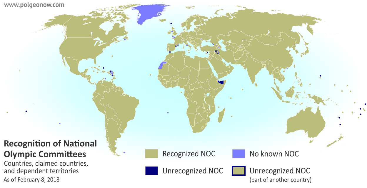
The ten dependent territories allowed to participate in the Olympics are only a select few, leaving most of the world’s overseas dependencies without their own teams (though athletes from the territories are allowed to apply for their patron countries’ teams). Self-proclaimed countries not recognized by the UN aren’t usually admitted either, even if they’re effectively independent. In fact, there are quite a few dependent territories and unrecognized countries that have created National Olympic Committees, or said they plan to, but haven’t been recognized by the IOC:

Countries not in the Olympics: World map marking independent countries (de facto sovereign states) and dependent territories that don't have IOC-recognized National Olympic Committees, and are thus not allowed to send their own teams to the Olympic Games
Click to enlarge: Territories and self-proclaimed countries not allowed to send teams to the Olympics.

Africa
 Somaliland (self-proclaimed country)

Americas
 Anguilla (UK territory)
 Montserrat (UK territory)
 Turks & Caicos (UK territory)

Asia
Kurdistan (autonomous region of Iraq)
 Macau (autonomous region of China)[3]

Europe
 Abkhazia (self-proclaimed country)
 Catalonia (region of Spain)
 Faroe Islands (associated state of Denmark)
 Gibraltar (UK territory)
 Northern Cyprus (self-proclaimed country)
 South Ossetia (self-proclaimed country)

Oceania
 New Caledonia (territory of France) [4]
 Niue (associated state of New Zealand) [4]
 Norfolk Island (outlying island of Australia) [4]
 Northern Mariana Islands (US territory) [4]
 Tahiti (territory of France) [4]
 Tokelau (territory of New Zealand) [4]
 Wallis and Futuna (territory of France) [4]

How many countries are attending the PyeongChang 2018 Olympic Games?

Being an Olympic Nation doesn’t mean you have to actually send athletes to every Olympics. And unlike the Summer Games, which sometimes feature every single recognized Olympic nation, it’s normal for a lot of countries to skip the Winter Olympics. Not surprisingly, most of the absentees are tropical countries where there are few chances to practice winter sports – though there are always a few exceptions. 

This year there are 91 nations participating in the games – a record high for the Winter Olympics, beating out the previous record of 89 nations from Sochi 2014. Adding in the special “Olympic Athletes from Russia” group and the joint Korea team (both discussed above under “Which countries are new?”), that leaves a total of 93 different flags athletes will compete under at PyeongChang 2018. Wikipedia has a full list of the participating teams, complete with links to the athlete rosters for each country.

About 20 of the teams are from tropical countries and territories, while the only real cold northern country missing is Russia, due to the ban on its official national team. Still, there are a few countries with snowy mountain ranges – like Nepal, Peru, Afghanistan, and Tajikistan – that are also sitting it out this winter.

Because the separate North Korea and South Korea teams are marching together under “Korea”, there will only be 91 delegations in the Parade of Nations (though North and South Korea will still compete under their separate flags for most sports). There’s a complete, ordered list of the 2018 Parade of Nations countries and flagbearers at Wikipedia.

Are you watching the Parade of Nations? Tweet to us @PolGeoNow with your thoughts or questions!

Footnotes

[1] The five associations are based closely on the world’s continents, but with a few quirks: The southern Caucasus, Israel, and eastern Turkey are part of the European association despite traditionally being considered part of Asia; and the South American territory of French Guiana also falls under European jurisdiction, because it’s considered part of France and doesn’t have a separate team.

[2] “Chinese Taipei” is intended to be ambiguous, since most Taiwanese people consider themselves to be at least culturally Chinese. However, the use of “Taipei” is unfortunate for the two-thirds of Taiwan’s people who don’t live in or near the city of Taipei. This was especially awkward when the 2009 World Games (an Olympics-affiliated event) were held in Kaohsiung, Taiwan – something of a rival city to Taipei. 

[3] Although Macau’s NOC isn’t recognized by the IOC itself, it has been accepted as a member of its continental organization, the Olympic Council of Asia. Macau participates in the Asian Games and Paralympic Games, but not in the regular Olympics.

[4] Seven dependent territories in Oceania are associate members of the Oceania National Olympic Committees. They’re allowed to participate in some regionally-organized sporting events, but not in the Olympics.

Map: Costa Rica & Nicaragua Settle Border Dispute in Court

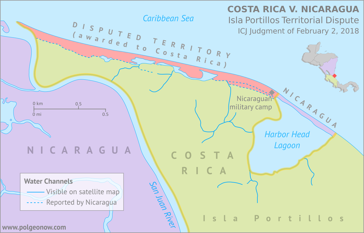
Conflicto Isla Portillos - mapa 2018. Map of Costa Rica and Nicaragua's post-2015 territorial dispute on Isla Portillos at the mouth of Rio San Juan, showing the judgment of the International Court of Justic (ICJ) of February 2018, based on the case filed in 2017. Includes key features such as Harbor Head Lagoon, the Nicaraguan military camp, the disputed territory along the beach, and the small water channels used to argue Nicaragua's case. Colorblind accessible.
Map by Evan Centanni, based on materials submitted to the court. Contact for usage permissions.

World Court Rules on Costa Rica vs. Nicaragua

What happens when two countries draw their border along a river, then the river changes course? The world got to find out yesterday, as the UN’s International Court of Justice (ICJ) released its judgement on a border dispute between Nicaragua and Costa Rica. Though the court’s ruling was dominated by a related request to define the two countries’ borders at sea, it also involved a tiny sliver of land in a temperamental river delta.

The Isla Portillos Dispute

The disputed land territory involves a slice of coastline at the northern tip of Isla Portillos, an island located in the delta of the River San Juan de Nicaragua (Isla Portillos is sometimes considered part of the larger Calero Island). The border once ran along the river and into a lagoon before hitting the Caribbean Sea, but a hundred years of natural changes to the area’s geography messed that all up.

In this court case – the latest of several between the two countries – Nicaragua claimed that a tiny channel of water still connected the river to the lagoon, separating a narrow strip of Nicaraguan coastline from the island’s Costa Rican interior. But Costa Rica argued that the channel, if it even existed, had been artificially built by Nicaragua, and that the Nicaraguan sandbar that once did exist had long ago eroded away. In this view, a small Nicaraguan military camp on the beach – recently moved from the mouth of the lagoon to a spot slightly farther west – was an illegal occupation of Costa Rican territory.

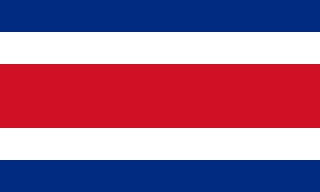
Flag of Costa Rica (civil)Country Name:  
• Costa Rica (English, Spanish)
Official Name:  
• Republic of Costa Rica (English)
• República de Costa Rica (Spanish)
Capital: San José

Costa Rica admitted that the lagoon itself, and the piece of beach now separating it from the sea, still belonged to Nicaragua, leaving a tiny piece of Nicaraguan territory separated from the rest of the country. Even so, Costa Rica warned that Nicaragua might even lose all of that if the beach erodes away completely (international law doesn’t normally allow a country to claim a body of water without owning some piece of land next to it).

Judgement Day: Who Owns the Beach on Isla Portillos?

When it released its decision this yesterday, the ICJ agreed with Nicaragua that the status of the disputed territory hadn’t already been decided by earlier court rulings. But in the end the judges sided almost entirely with Costa Rica, agreeing that the beach between the lagoon and the mouth of the river are Costa Rican. In a decision made by a vote of fourteen to two, Nicaragua was left with just the lagoon and its short strip of beach, and was ordered to move the military camp off of Costa Rican land.

In an unusual move, the court also decided that the sea just outside of the lagoon would be Costa Rican waters. Normally, any coastline controlled by a country automatically gives it the rights to at least some of the neighboring waters, and denying that to Nicaragua might turn out to be controversial.

The Story of a Border Dispute

The tale of the Isla Portillos dispute goes back almost 200 years, involving a US president, a Confederate general, and a lot of creative geographical analysis.

Costa Rica and Nicaragua declared independence from Spain together in 1821, and went their separate ways after the Federal Republic of Central America fell apart in 1838. But from early on, they scuffled over exactly which land belonged to which country. In 1858, they set out to end the disputes by precisely defining the course of their border in the Cañas–Jerez Treaty of Limits.

That treaty set the right bank of the San Juan River as the border in the Caribbean coastal area, with the boundary ending at a spot called Punta Castilla by the river’s mouth. After bringing in US President Grover Cleveland as a mediator from 1886 to 1888 to settle remaining disputes over the treaty’s validity, plus the exact location of Punta Castilla, the border seemed to be settled once and for all.

>Only one problem: Rivers change course over time. By 1896, when the Costa Rican and Nicaraguan governments set out to actually mark their border with pillars on the ground, the end of the San Juan River had split into three separate channels, hitting the ocean kilometers apart from each other. Naturally, each country chose whichever border interpretation gave it the most land, leaving the intervening islands disputed once again.

Map of the border between Nicaragua and Costa Rica at the Caribbean mouth of the San Juan River as decided by the 1897 Alexander award, including prior claims by each country. Includes Harbor Head Lagoon, the Taura Branch of the San Juan River, and the island now known as Isla Portillos.
Click to enlarge: Map of General Alexander’s 1897 border decision, and the Nicaraguan and Costa Rican claims of the time. The largest island, cut off by the Taura Branch, is Isla Portillos. Public domain illustration (source).

Still, it was no surprise that some disputes would come up in the process of marking out the border, and that’s why they had another third-party mediator on hand.

Grover Cleveland – US president again after a break from 1888-1893 – couldn’t participate in person, so instead he sent his friend Edward Porter Alexander, an engineer and former Confederate general from the US Civil War.

General Alexander decided the border should run as close as possible to the original Punta Castilla spot, now located at the northeastern corner of Harbor Head Lagoon on the San Juan’s middle channel. Realizing the river’s course would keep changing in the future, Alexander specified that the future border should always follow the east side of the lagoon and then continue up “the first channel met” into the San Juan River proper.

The Dispute Enters the 21st Century

Alexander’s solution continued to work for about a century. But over the decades Punta Castilla was swallowed by the sea (its original location now lies about a kilometer straight out to sea from the edge of the lagoon), and by the 2000s, another problem had come up: Harbor Head Lagoon wasn’t connected to the San Juan River at all anymore. Or was it?

Nicaragua claimed it had found a tiny channel through the forest connecting the lagoon to the river even more directly than before (“the first channel met”, remember?). This left the whole northern tip of Isla Portillos, roughly from the lagoon westward, as the supposed territory of Nicaragua. The dispute came to a head in 2010, when a Nicaraguan military commander infamously used Google Maps to argue that his troops had the right to land on Isla Portillos and begin dredging operations there.

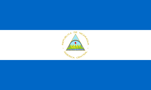
Flag of NicaraguaCountry Name:  
• Nicaragua (English, Spanish)
Official Name:  
• Republic of Nicaragua (English)
• República de Nicaragua (Spanish)
Capital: Managua

Costa Rica took Nicaragua to court at the ICJ over its actions, and in 2015 the judges agreed with Costa Rica: The newly-claimed channel wouldn’t fly, and the Nicaraguan troops would have to leave. Costa Rica took this to mean the entire island was Costa Rican, except for the lagoon, which was directly mentioned in the border treaty, and the strip of beach that now separated the lagoon from the sea. But the court made a point of not drawing exact borders, and took a pass on saying who owned the island’s narrow coastal strip.

Back to Court: The 2017-2018 Dispute

Soon, Nicaragua began arguing that a tiny piece of the original river channel still ran just behind the beach, connecting the lagoon to the present river mouth. Costa Rica insisted the strip of Nicaraguan land north of the channel had long ago eroded into the sea, and there was only a “channel” remaining behind the beach if Nicaragua had dug a new one farther back.

In 2017, Costa Rica took Nicaragua back to court over the disputed strip of coastline, and yesterday the judges again took the side of Costa Rica, by a vote of fourteen to two. They concluded that there is no more channel, and that the whole beach is Costa Rican except for the part directly between the lagoon and the Caribbean Sea – now a tiny enclave of Nicaraguan territory separated from the rest of the country.

So the dispute is resolved again, for now. But one thing’s for sure: We haven’t seen the end of changes to the area’s riverbanks and coastlines. It’s probably just a matter of time before a new variation of this centuries-old territorial dispute pops back up. Judge Awn Al-Khasawneh, who voted against awarding the land to Costa Rica, and felt the court should have come up with a more permanent solution, quoted medieval Persian poet Hafez of Shiraz in his dissenting opinion: 

“The house of hope is built on sand…”

Need ALL the details? You can find complete documentation of the court case on the ICJ website: records for the Isla Portillos case here, with the judgement and related documents here.