Syrian Civil War Control Map: June 2015 (Subscription)

There are newer versions of this map available. To see them, view all Syria updates.

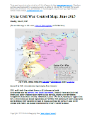
Map of fighting and territorial control in Syria's Civil War (Free Syrian Army rebels, Kurdish groups, Al-Nusra Front, Islamic State (ISIS/ISIL), and others), updated for late June 2015. Highlights recent locations of conflict and territorial control changes, such as Palmyra, Ariha, Tel Abyad, Ayn Issa, and Hasakah, Kobani, and Suwayda.

Download PDF:
Buy now

(Subscribe via Paypal to view all premium content online)

Research by T.H., with additional reporting by Evan Centanni

Since late May, rebels have consolidated their power in Syria’s northwest, Kurdish forces have extended their control across most of the border with Turkey, and the Islamic State continues advancing in the direction of Damascus.

See all this and more on the newest update to PolGeoNow’s popular Syria control map, which includes a timeline of changes since our previous Syria map report in May.

This map and report are exclusive premium content, available to paid subscribers or for separate purchase.
Download PDF (US$19.99)

Exclusive map report includes:

  • Up-to-date map of current territorial control in Syria, color-coded for the Assad government, rebel groups, Islamic State (ISIS/ISIL) extremists, and Kurdish YPG forces. Special symbol indicates rebel-held towns dominated by Al Qaeda affiliate Jabhat al-Nusra.
  • Detailed indication of city-by-city control, highlighting key towns and other locations relevant to current events.
  • Locations of recent fighting and military operations, including Tel Abyad, Ayn Issa, Hasakah, Kobani, Palmyra, Ariha, Suwayda, and more.
  • Timeline of important events and changes to territorial control since May 24, 2015, with links to sources.

MEMBERS CLICK HERE TO PROCEED TO ARTICLE AND MAP

NOT A MEMBER YET? SUBSCRIBE NOW!

Yemen’s Civil War: Map of Control in June 2015

There are newer versions of this map available. To see them, view all Yemen updates.

This is part of a series of Yemen maps and infographics created in collaboration between PolGeoNow and CIGeography. Part 1 was the Map & Infographic of Foreign Military Deployments in Yemen, and Part 2 was War in Yemen: Map of Territorial Control (April 2015).
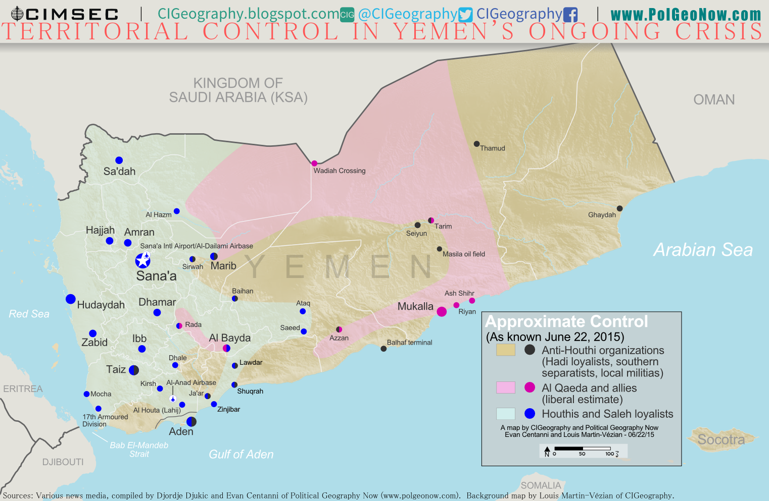
Map of territorial control in Yemen as of June 22, 2015, about two months into Saudi Arabia's military intervention, including territory held by the Houthi rebels and former president Saleh's forces, president-in-exile Hadi and the Southern Movement, and Al Qaeda in the Arabian Peninsula (AQAP).
Map by Louis Martin-Vézian and Evan Centanni (click to enlarge). All rights reserved.

Subscribers click here to view this article in the ad-free members area. Not a member yet? Subscribe now!

Timeline by Djordje Djukic, with additional reporting by Evan Centanni

Houthi Control Spreading Despite Saudi Airstrikes
Since our previous Yemen control map update in early April, Saudi Arabia and its coalition partners have continued their air and sea campaign in support of the ousted Yemeni government of President Abd Rabbuh Mansur Hadi, supported by parts of the Yemeni military and allied local and southern forces. But two months into the intervention, their opponents, the northern Houthi rebels and forces loyal to former president Ali Abdullah Saleh, have continued to expand eastward. Meanwhile, Al Qaeda fighters have consolidated their control in parts of eastern Yemen, and the port city of Aden is still divided by frequent battles.

See Also: CIGeography infographic on foreign military activity in Yemen 
Flag of YemenCountry Name:  
• Yemen (English)
• Al-Yaman (Arabic)
Official Name:  
• Republic of Yemen (English)
• al-Jumhūriyyah al-Yamaniyyah (Arabic) 
Capital: Sana’a

Chronology of Events
The following is a timeline of major political events and changes to territorial control since PolGeoNow’s April 3 Yemen control map report.

April 4, 2015
Hadi troops, reinforced by Saudi weapons drops, pushed back the Houthis from the Crater district in Aden.

April 5, 2015
The Houthis advanced into the central Mualla district of Aden, capturing the provincial headquarters. Also, fighting in the Houthi-held city of Lawdar (Loder) left 24 people dead, including 21 Shiite militiamen.

April 7, 2015
The Hadhramout Tribal Alliance and pro-Hadi militiamen claimed to recapture Mukalla from Al Qaeda in the Arabian Peninsula (AQAP), but residents reported Al Qaeda was still in control of around half of the town. In addition, AQAP militants captured Wadiah border crossing with Saudi Arabia, killing two soldiers.

April 9, 2015
Houthi and allied forces captured Ataq, the provincial capital of Shabwah Governorate, after a deal was reached with local leaders and security officials

April 14, 2015
The UN Security Council passed a resolution for an arms embargo to be applied to the Houthis and their allies, with 14 in favor and Russia abstaining, after its request for the embargo to include all parties to the conflict was refused. The same day, the Houthis retreated from Aden’s Khor Maksar district after prolonged street fighting.

April 16, 2015
Al Qaeda sized the Riyan airport and Mukalla’s seaport and oil terminal, with the main government brigade responsible for security fleeing after a brief clash with the militants outside the city. In addition, the fighters captured a massive weapons depot that contained dozens of tanks, Katyusha rocket launchers and small arms. With this advance, Al Qaeda consolidated its hold on Hadhramaut province, and is believed to be back in control of most of Mukalla.

April 17-18, 2015
Houthi and allied forces attacked the base of the 35th Armored Brigade in Taiz, Yemen’s third largest city, after the brigade announced its loyalty to Hadi.

April 21, 2015
Saudi Arabia declared an end to its “Decisive Storm” air campaign, saying it would scale down the airstrikes at the request of President Hadi, but not claiming it would stop them altogether. Instead, a more limited military campaign was announced and named  “Renewal of Hope”, with the stated aim of preventing the Houthis from targeting civilians or making any territorial gains.

April 22, 2015
The Houthis captured the military base in Taiz.

April 23, 2015
The Saudi-led Coalition conducted 20 air-strikes against Houthi targets, despite saying earlier that it was winding down the campaign.

April 25, 2015
Heavy fighting took place in Marib province as pro-Houthi forces attempted to advance into the Sirwah district. Four days earlier, a local pro-Hadi official claimed that between April 2 and 22, 150 pro-Houthi and 27 anti-Houthi fighters had been killed in clashes in the province.

April 26, 2015
Pro-Hadi forces reportedly captured “several districts” in Taiz, despite losing the military base a few days earlier.

April 27, 2015
According to the Hadi government, 1,000 civilians had been killed since the start of the conflict.

April 28, 2015
A Houthi counter-attack resulted in the recapture of the Russian and German consulates and Hadi’s residence in Aden, after advances in the Khor Maksar district, and pro-Houthi forces to the north of the city made a push to the west in an attempt to recapture territory previously lost.

April 29, 2015
Houthi fighters advanced into the center of Aden, taking territory from the Russian consulate to the Crater business district, and were once again largely in control of the city’s airport. Houthi forces also repelled pro-Hadi counterattacks in the Khor Maksar and Mualla districts of the city. According to Aden’s health ministry, 375 civilians had been killed and 2,500 wounded since the battle began.

May 3, 2015
Twenty soldiers, initially described as members of the Saudi-led coalition, reportedly landed in Aden on a reconnaissance mission. Another account put the number of soldiers at 50, while Saudi Arabia denied any ground troops were sent to Yemen. The next day, the unidentified soldiers reportedly took part in fighting near the Aden airport, with pro-Hadi forces storming parts of the facility, while a spokesman for the allied Southern Popular Resistance retracted an earlier statement that the soldiers were part of the coalition, instead saying they were homegrown special forces from the south. Later, the pro-Hadi Yemeni foreign minister stated the soldiers were members of the pro-Hadi government forces who had been sent to Gulf countries to be trained before returning to Yemen.

May 6, 2015
Fighters associated with Al Qaeda captured Ash Shihr, a port east of Mukalla. 

May 7, 2015
Saudi Arabia and the United States declared a five-day ceasefire to allow aid to enter Yemen, while the UN humanitarian coordinator stated more than 1,400 people had been killed and 6,000 injured in the conflict since March 26.

May 10, 2015
The Yemeni Army accepted the proposed five-day ceasefire, and the Houthis welcomed any form of a truce. However, the same day, two coalition airstrikes hit former president Ali Abdullah Saleh’s home in Sana’a. Saleh was not there at the time, and in response to the attack openly declared his alliance with the Houthis. (Saleh had already been apparently allied with the Houthis for some time before this.)

May 11, 2015
A Moroccan fighter jet belonging to the Saudi-led coalition went missing, along with its pilot, in Yemen, and was possibly shot down by Houthi forces. At the same time, one person was killed in a Saudi town, close to the Yemeni border, by Houthi shelling. This brought the overall death toll from Houthi cross-border rocket and mortar attacks, which started the previous week, to 11.

May 12, 2015
The five-day ceasefire commenced in the evening, but some ground fighting continued.

May 13, 2015
Ceasefire violations reported in the first 24 hours included: a coalition airstrike, shelling by coalition warships on an area west of Aden, and fighting during a Houthi attempt to storm Dhale.

May 17, 2015
The five-day ceasefire ended and the Saudi-led coalition immediately resumed its airstrikes.

May 26, 2015
Pro-Hadi fighters captured Dhale and the command center of the pro-Houthi 33rd Armoured Brigade after expelling Houthi fighters from the town.

May 28, 2015
The pro-Hadi governor of Sana’a, Abdulghani Jamil, was killed along with his nephew in a shootout when Houthi fighters attempted to detain him.

May 30, 2015
The Houthis took over the city of Saeed in Shabwah province, after local leaders changed their allegiance.

June 4, 2015
According to the United Nations, the death toll from the conflict since March 19, up to May 31, reached 2,288. Another 9,755 people were wounded. Of the casualties, 1,160 of the dead were civilians, as were over 2,800 of those injured.

June 5, 2015
The Houthis and the Hadi government agreed to attend UN-brokered peace talks in Geneva.

June 6, 2015
Saudi Arabia shot down a Scud missile fired from Yemen toward a military base in southwestern Saudi Arabia. The Scud was brought down using a US-supplied Patriot surface-to-air missile defense system.

June 12, 2015
UNESCO condemned a Saudi airstrike on the old quarter of Yemen’s capital, a centuries-old heritage site considered a “jewel” of Islamic culture. The attack killed five people and destroyed several homes.

June 13, 2015
The Houthi rebel delegation, which was supposed to attend peace talks with the Hadi government, refused to board the plane for Geneva. The reason given was that the Houthis objected to there being two separate delegations in Geneva – one representing the Hadi government and the second (the Houthis) being seen as representing a “coup”. According to a Houthi representative, this was meant to pressure the Houthis to withdraw from Sana’a and did not foster an environment suitable for the continuation of broader multi-party talks.

June 14, 2015
Houthi and pro-Saleh Army forces captured Al Hazm, the capital of Jawf province, which includes much of the border with Saudi Arabia.

June 16, 2015
The Houthi delegation left for the Geneva peace talks after the United Nations agreed to broaden the negotiations to include the Socialist and Haqq parties.

June 19, 2015
The peace negotiations in Geneva ended without an agreement, but UN envoy Ismail Ould Cheikh Ahmed was optimistic that in a matter of time a ceasefire could be reached under which the rebels would withdraw from towns they had seized in the previous months, with both sides seeming supportive of the plan.

Following this story? View all Yemen maps on PolGeoNow.

Graphic of Yemeni flag is in the public domain (source).

Map of Rebel Control in Mali: June 2015

(To see other maps in this series, view all Mali articles.)

Map of territorial control in Mali as of June 2015. Includes separatist rebel control (CMA, MNLA, MAA, HCUA) and locations of UN peacekeeper (MINUSMA) deployments, as well as the location of a brief takeover by Al Qaeda in the Islamic Maghreb (AQIM).
Map by Evan Centanni, modified from this map by Orionist, Carport, and NordNordWest. License: CC BY-SA.

Subscribers click here to view this article in the ad-free members area. Not a member yet? Subscribe now!

Article by Evan Centanni

Separatist Return to Power
At the time of our last Mali rebel control map report, separatist rebels had just allowed the Malian government to resume control of the north as part of a ceasefire agreement ahead of elections. The rebels had for a time resumed control of the region after a French-led military intervention pushed out the religiously-oriented rebel groups who had usurped the initial separatist rebellion. In July 2013, Mali’s territory was again united for the first time in over a year.

But that was two years ago now. Skirmishes between government and separatist forces continued after the elections, and by summer of 2014, towns began to fall once again under separatist control. The National Movement for the Liberation of Azawad (MNLA) and allied groups once again ruled large parts of Mali’s sparsely-populated extreme north, where they had declared an independent country in April 2012.

Today, the allied separatist forces appear to control much of the region around Kidal, and have proven capable of attacking much farther south in recent months. However, they have gradually backed down from their insistence on full independence, and peace may finally be around the corner. A new agreement offering partially-devolved powers to the north has been signed by the Malian government and two small members of the separatist alliance, with the MNLA and two other major groups saying they too will sign on June 20.

Flag of MaliCountry Name:  
• Mali (English, French, Bambara)
Official Name:  
• Republic of Mali (English)
• République du Mali (French) 
• Mali ka Fasojamana (Bambara)
Capital: Bamako

Timeline of Events
The following is a timeline of major events and changes to territorial control since July 2013.

2013.07.01 A new UN peacekeeping mission, the United Nations Multidimensional Integrated Stabilization Mission in Mali (MINUSMA), officially begins. It replaces an early, more hastily-formed multinational force composed of troops from neighboring countries.

2013.07.28 Mali holds the first round of its presidential elections.

2013.08.02 The results of the first round of elections are announced: candidates Soumaila Cisse and Ibrahim Boubacar Keita will advance to the runoff election.

2013.08.11 The runoff presidential election is held, with Keita declared the new president-elect of Mali.

2013.08-2014.05 Regular clashes continue in northern Mali between separatists, pro-government forces, and others, but no reports emerge of rebels capturing territory.

2014.05.20 The town of N’Tilit is occupied by MNLA separatists (source: ACLED).

2014.05.21 A government attempt to assert greater control over the town of Kidal results in a resounding defeat, with separatists seizing the whole city.

2014.05.22 After the capture of Kidal, the MNLA rebels claim they have also taken over Anefis, Aguelhok, Tessalit, Ménaka, Ansongo, Anderamboukane and Léré, though government officials soon deny this. A BBC correspondent “confirms” that the Malian army has withdrawn from Anefis, Aguelhok, Tessalit, and Ménaka.

Later events will suggest that Ménaka and Anefis were indeed under rebel control, but that Léré was not. The status of the other towns remains unclear (Tessalit and Aguelhok, though inside the separatist-dominated Kidal region, are also home to contingents of foreign troops).

2014.10.16 N’Tilit is taken from the MNLA by fighters of the Self-Defense Group of Imghad Tuareg and Allies (GATIA), a pro-government, Tuareg-majority militia.

2014.10.18 GATIA and allied militias capture Tessit from the MNLA, which had retreated there after its defeat in N’Tilit.

2014.10.28 At a meeting in Anefis, the three largest separatist groups in Mali’s north form a unified military command, called the Coordination of Azawad Movements (CMA). The member groups are the MNLA, the Arab Movement of the Azawad (MAA), and the High Council for the Unity of Azawad (HCUA). The HCUA is a Tuareg-majority group formed largely from former members of Ansar Dine, the group which helped the MNLA take over in 2012, but sought to turn Mali into a religious state until it was defeated during the French intervention. Two smaller groups will later join the CMA as well.

2014.12.26 The MAA, an Arab-majority member group of the CMA, is reported to be in control of Taoudenni, the largest settlement in Mali’s vast northwestern desert.

2015.01.05 Fighters from Al Qaeda in the Islamic Maghreb (AQIM) briefly capture a major Malian military base in the central town of Nampala. AQIM has no direct connection to the separatist rebels, but has benefited from chaos in the north.

2015.02.04 GATIA fighters capture Tabrichat from CMA separatist forces.

2015.04.27 MNLA forces are pushed out of Ménaka by GATIA and a pro-government faction of the MAA.

2015.05.14 After internationally-brokered talks in Algeria, CMA separatists agree in principal to a peace deal with Mali’s government, which would allow more devolution of power to the northern regions. Two smaller members of the CMA sign the agreement, but the MNLA, MAA, and HCUA say they are not yet ready to sign.

More Control Maps:
Map of Territorial Control in Iraq (May 2015)
Map of Boko Haram Control in Nigeria (May 2015)
Syrian Civil War Territorial Control Map (May 2015)

Graphic of Malian flag is in the public domain (source).
Vatican City Administration Recognizes Palestine as a Country (map)

(Keep up with changes to Palestine’s situation: view all Palestine updates.)

Map of countries that recognize the State of Palestine as an independent country, updated for June 2015 with recent addition Vatican City (Holy See) highlighted
Click to enlarge: Countries recognizing the State of Palestine in green, with most recent addition highlighted. Palestine in magenta (circled). Map by Evan Centanni, modified from public domain graphic (source).

Subscribers click here to view this article in the ad-free members area. Not a member yet? Subscribe now!

Article by Evan Centanni

Vatican Recognizes Palestine
Last month the Holy See – the official administration of the Roman Catholic Church and government of Vatican City – became the latest national government to recognize Palestine as an independent country. The explicit acknowledgement of Palestine’s statehood came with a treaty signed May 13, 2015, regarding the activities of the Catholic Church within Palestine’s territory. 

In the face of criticism from Israel’s government and other groups, the Vatican played down the significance of the treaty, saying that the Holy See had really recognized Palestine ever since supporting the UN vote on Palestinian’s statehood in 2012. However, official diplomatic recognition usually requires an explicit statement by the country’s government, so the Holy See was presumed not to formally recognize Palestine until now.

Learn More: What’s the difference between Vatican City and the Holy See?

Vatican City is now one of about half the world’s countries whose government recognizes both Palestine and Israel as independent countries. But Palestine is recognized by only a few countries in Europe, and the Holy See is only the fifth European government to recognize since the end of the Cold War. The last was Sweden in October 2014, preceded by Iceland in 2011, Montenegro in 2006, and Bosnia in 1992.

Flag of Palestine Country Name:  
• Palestine (English)
• Filasṭīn (Arabic)
Official Name:  
• State of Palestine (English)
• Dawlat Filasṭin (Arabic)
Capital: 
• Jerusalem (claimed)
• Ramallah (administrative)

Palestine: Disputed Country
The Palestinian Liberation Organization (PLO) declared independence for Palestine in 1988, and has been seeking international acceptance for the proclaimed country ever since. Though its claimed territories are disputed and largely occupied by Israel, the “State of Palestine” is recognized by more than two-thirds of the world’s countries, and is also treated as a country by the UN General Assembly, where it is an “Observer State” but not a member.

The Holy See also has Observer State status in the UN, making Vatican City and Palestine the only two countries that are acknowledged as independent by the UN, but do not have votes in the General Assembly.

The number of individual countries recognizing Palestine as independent has grown gradually over the past decades. Last year we reported that 135 UN member states officially recognized Palestine (70% of all UN members), and this is still the case today, since Vatican City is not a full UN member. Palestine is also recognized by the proclaimed government of Western Sahara, a fellow disputed country whose independence is not formally recognized by the UN at all.

Related:
Is Palestine Really a Country?
Palestine Recognized as a Country by the U.N.
Map of Countries Recognizing Kosovo