2016 Year in Review: Country & Border Changes

Inside this Review of 2016:
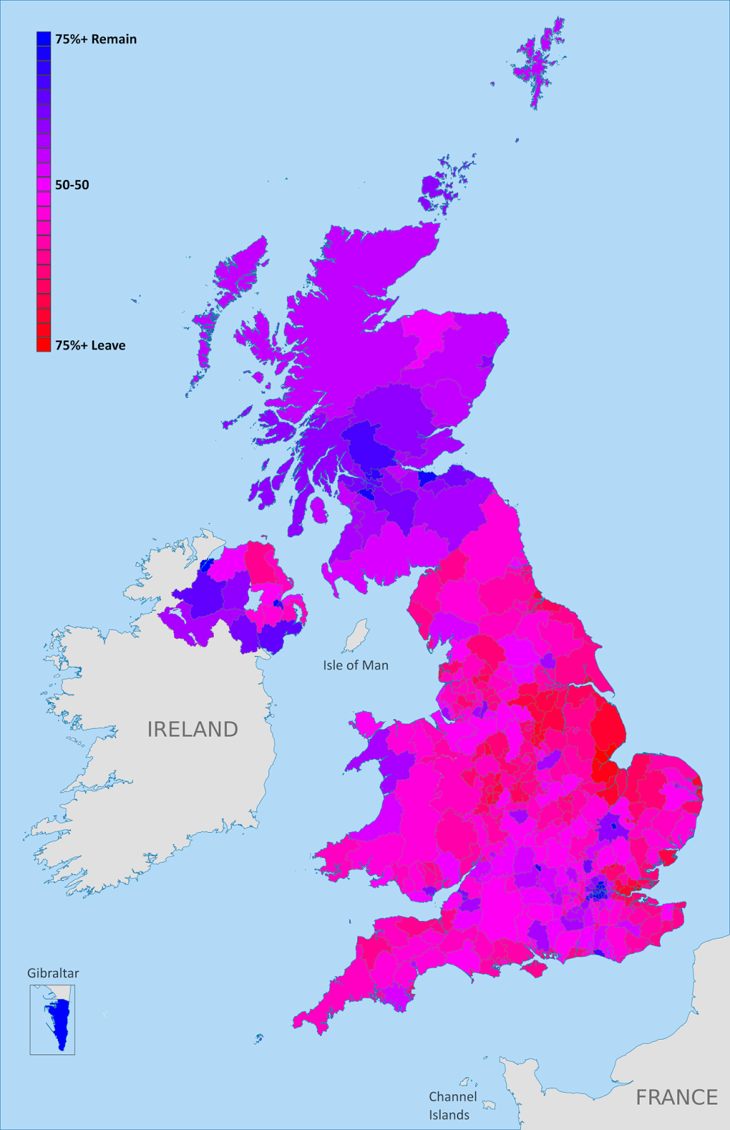
Map of election results from the UK’s “Brexit” referendum on leaving the European Union
    • Country name, capital, and flag changes
    • Border changes and disputed territories 
    • Separatist states and proposed new countries
    • Recognition of disputed countries 
    • Countries joining (and leaving) international organizations
    • Sea borders and seabed claims
    • New states and provinces within countries
    • Changes to countries’ coastal contours and official languages

        And in companion articles:
        Rebel Control Around the World in 2016 
        Time Zones that Changed in 2016 

        It’s PolGeoNow’s mission to track changes to the world’s countries, borders, and territories, whether it’s happening formally on the books or unofficially on the ground. When new countries appear, borders change, and territorial disputes arise or are settled, you’ll hear about it here. With 2016 now concluded, here’s our look back at the events of the year!

        (For extra coverage of geography events in 2017, follow @PolGeoNow on Twitter!)

        Country Name Changes

        In 2016, the Gambia registered an official name change with the UN, switching its full formal name from “Republic of the Gambia” to “Islamic Republic of the Gambia”. This confirmed the possible name change that we had reported on in our review of 2015

        The Czech Republic is now officially “Czechia” for short
        (Map by David Liuzzo (CC BY-SA))

        The other big country name news last year came from the Czech Republic, which registered “Czechia” as its official short name, keeping “Czech Republic” for formal circumstances.

        Also in the news in 2016 was the US government’s quiet change of policy regarding the name of Myanmar, also known as Burma. “Burma” was the official name of the country until it was changed to “Myanmar” in 1989, and the US had continued using the old name as a protest against the undemocratic government that initiated the name change. However, this fall the US administration appeared to be ending that policy after using the name “Myanmar” in an official press release.

        See all PolGeoNow articles on country name changes

        Flag and Capital Changes

        As far as PolGeoNow has been able to determine, no country changed its flag or capital city in 2016. But that doesn’t mean there wasn’t any news at all…

        New Zealand’s people voted against making this their new flag

        Fiji, which had announced a plan to remove the British “Union Jack” design from its flag in 2015, finally abandoned the plan in August 2016 after months of delays. Meanwhile, New Zealand held the second round of its flag change referendum vote, but citizens chose to keep the old flag rather than change to a new design chosen in a 2015 vote from a government shortlist of candidates.

        In the US state of Mississippi, a political dispute over the state flag – which includes the battle emblem of the 19th Century separatist Confederate States of America, seen by many as a symbol of slavery – continued into 2017.

        See all flag change articles on PolGeoNow

        Border Changes

        Though no borders officially changed in 2016, Belgium and the Netherlands did agree on an adjustment to their border, which will go into effect after it’s ratified by their legislatures. Meanwhile, consulting firm Stratfor reported that the practical border between Georgia and breakaway South Ossetia is continuing to creep slowly southward, increasing the size of the unrecognized country (there’s no officially agreed-upon border between the two countries, since neither Georgia nor most of the world recognizes South Ossetia’s independence).

        Remote Norfolk Island was integrated into Australia in 2016
        (Map by TUBS/Wikimedia CommonsCC BY-SA)

        Another change to practical border arrangements happened between Australia and its external territory of Norfolk Island, which in 2016 was designated as “domestic” for travel purposes. Australia’s external territories are technically considered part of the country already, but have varying degrees of integration with the Australian mainland.

        And while the Netherlands and Belgium were finalizing their border agreement, another proposed adjustment in Europe died. A popular campaign for Norway to gift a mountaintop to Finland as a 100th birthday present eventually succeeded at being considered by the Norwegian government, but was ultimately rejected.

        See all articles on border changes

        Tiran and Sanafir Islands remain disputed between Egypt and Saudi Arabia, despite the Egyptian government’s efforts to give them up.

        Disputed Territories

        PolGeoNow didn’t discover any territorial disputes that were fully resolved in 2016, but one nearly was. In April, the Egyptian government signed a border treaty with Saudi Arabia, controversially giving the disputed islands of Tiran and Sanafir, previously controlled by Egypt, to the Saudis. Saudi Arabia quickly ratified the treaty, leaving the ball in the Egyptian parliament’s court. But before the parliament could vote, the deal was blocked by an Egyptian court, and the future of the agreement is still uncertain.

        Meanwhile, a sort of change territorial control happened at the disputed Scarborough Shoal in the South China Sea, claimed by both China and the Philippines. Chinese ships had been blockading the mostly-underwater reef since 2012, but after a warming of relations between the two countries, they began allowing Philippine ships to fish there again. But China hasn’t given up on its ownership of Scarborough Shoal, and reportedly still interferes occasionally with Philippine fishing operations.

        And though tensions with the Philippines were running lower by the end of 2016, China was still causing controversy in the South China Sea, as it began to place weapons on the artificial islands it’s built in the Spratlys, while also clinching its control of the Paracel Islands through the construction of both civilian and military infrastructure. Meanwhile Vietnam, which claims both the Paracels and the Spratlys, began matching China’s moves with construction and militarization of its own.

        Map of the border between Sudan and South Sudan, marking selected territorial disputes and border clashes in 2012. Includes inset map of April fighting in region of Heglig oil field.
        Sudan and South Sudan’s many border disputes became a little less hopeless in the last year

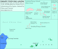
        Elsewhere in the world’s disputed territories, the the Japan-controlled Senkaku/Diaoyu Islands continued to be hotly contested by China, while heavy fighting broke out on the disputed Ethiopia-Eritrea border, and at the line of control between India and Pakistan in disputed Kashmir. On the other hand, the once hotly-disputed border of Sudan and South Sudan began to cool down, as demilitarization plans materialized and both countries said they were ready to work on peacefully settling their border disputes.

        Other disputed territories in diplomatic focus last year were the Hala’ib Triangle, where Sudan decided to take its dispute with Egypt to the UN Security Council; Gibraltar, which Spain pressured to switch allegiances after the UK’s Brexit vote; the Esequibo, which Guyana was preparing to defend anew from longstanding Venezuelan claims; and the Kuril Islands, which claimants Russia and Japan resumed discussions over.

        For disputes over territorial seas and other waters, see the “Sea Borders and Claims” section below.

        See all articles on disputed territories

        Declarations of Independence: New Countries in 2016?

        Just as in 2015, last year didn’t see any declarations of independence from serious breakaway states or credible aspiring countries. Uganda’s government claimed in late November that rebels operating near the border with the Democratic Republic of the Congo were operating a “parallel government” in the name of an independent “Yiira Republic” – but local officials played down the claim, saying the new country was neither a new idea nor a serious proposal.

        Meanwhile, a rebel threat to declare a “Niger Delta Republic” in southern Nigeria this August was canceled at the last minute, even as the Nigerian government allegedly killed and tortured protesters calling for the return of Biafra, a real breakaway state that existed from 1967-1970. Harder to verify were claims from Libyan officials that leaders of the Saharan Tebu people had launched a quiet diplomatic campaign for an independent country near Libya’s borders with Egypt, Sudan, and Chad.
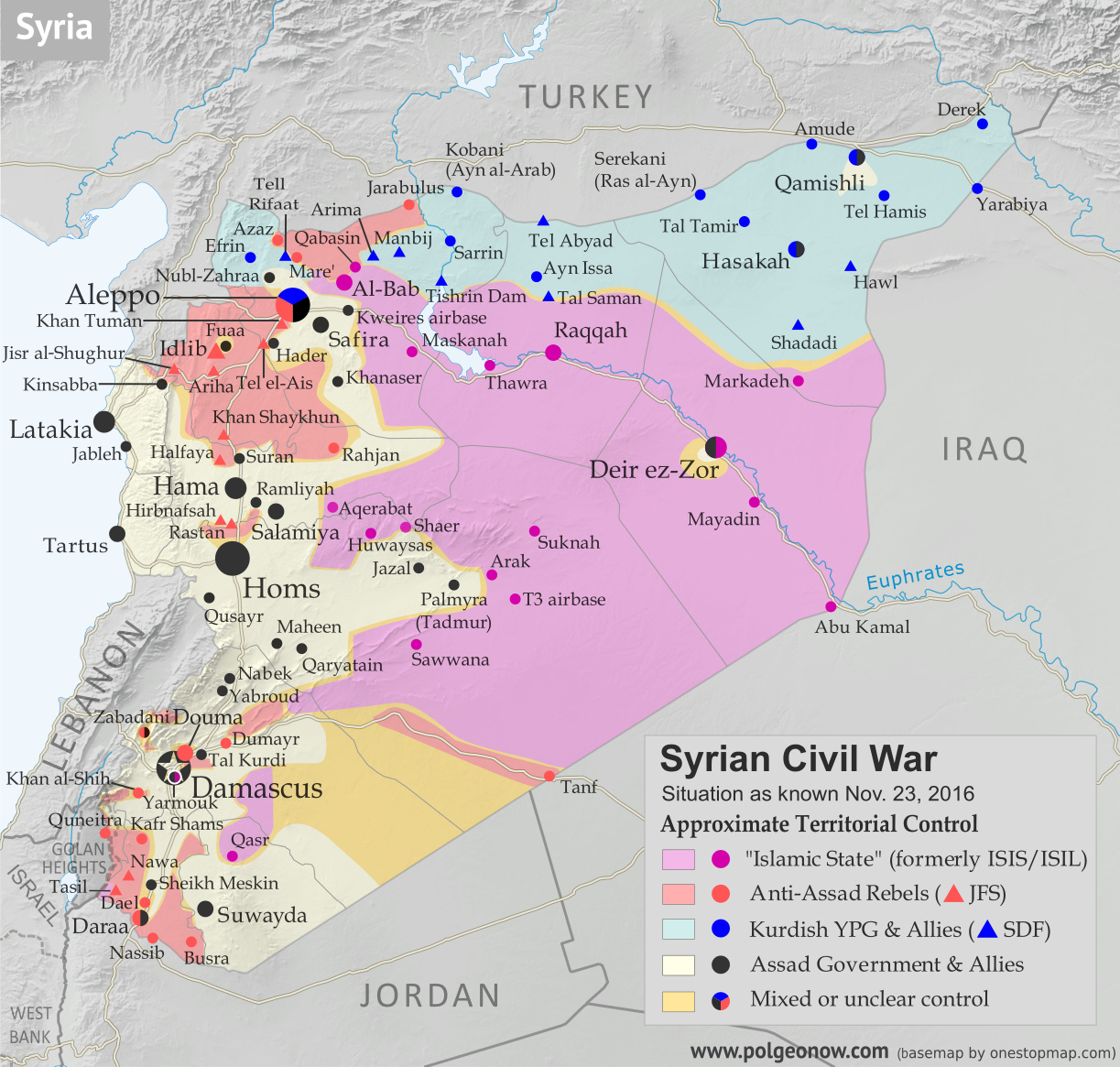
        Map of fighting and territorial control in Syria's Civil War (Free Syrian Army rebels, Kurdish YPG, Syrian Democratic Forces (SDF), Jabhat Fateh al-Sham (Al-Nusra Front), Islamic State (ISIS/ISIL), and others), updated to November 23, 2016. Now includes terrain and major roads (highways). Includes recent locations of conflict and territorial control changes, such as Al-Bab, Khan al-Shih, Tal Saman, Qabasin, and more. Colorblind accessible.

        On the other hand, the Kurdish-controlled area of northern Syria, which calls itself “Rojava”, began behaving more like an independent country in 2016, declaring a federal system of government without the approval of other parties in Syria’s civil war, and established “embassies” in Russia and the breakaway Donetsk People’s Republic of Ukraine.

        But two long-established breakaway states were looking at a possible end to their independence, with progress in negotiations to unify disputed Northern Cyprus with the Republic of Cyprus to its south, plus a plan announced by unrecognized South Ossetia to solidify its separation from Georgia by voting to join Russia.

        Popular but unlikely to succeed was a demand for the city of London to declare independence from the UK (#Londependence) so it could stay in the European Union after the Brexit vote, a proposal the city’s new mayor acknowledged but stopped short of fully endorsing. Scotland, on the other hand, was taken very seriously when its government said the Brexit could prompt it to have another vote on independence from the UK (Scotland voted in 2014 to stay in the UK).

        In Cameroon, some protesters reportedly demanded independence for a majority English-speaking part of the country (most of the country speaks French), while in the US, a small political party claimed that 40% of Californians supported their state declaring independence (and this even before Trump’s election as president). All the while, 2015’s celebrity micronation, the prospective libertarian utopia of Liberland, struggled to stay relevant as its “government” was blocked from entering its claimed territory, even while facing down a serious internal scandal.

        But the real dreamer of the year was Russian businessman, scientist, and UNESCO official Dr. Igor Ashurbeiyli, who announced the creation of a new pacifist country in outer space. The would-be nation, called “Asgardia”, is apparently a serious proposal, but seems unlikely to succeed at its bid to eventually join the UN, since international law seems to forbid countries from claiming territory in outer space.

        See all previous and future articles on newly declared countries

        Rebel Control of Territory

        Tracking territorial control in conflict zones is the mission of PolGeoNow’s conflict map subscription service, and many of our rebel control maps also appear in free articles here. In fact, tracking rebel control is such a big part of our work that we decided to publish a whole article just about territorial changes in 2016! Check it out here:

        Rebel Control Around the World in 2016

        Recognition of Disputed Countries

        Diplomatic recognition of disputed, partially-recognized countries continued to be slow in 2016. Despite France bluffing on a promise to recognize Palestinian independence if peace talks fell through, the State of Palestine failed to gain any new recognitions for the first time in a decade – perhaps signaling a return to the stagnant period from 1995 to 2004, when only one country declared its recognition of Palestinian independence.
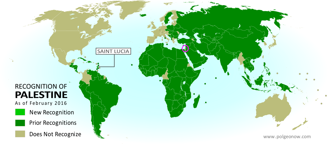
        Map of countries that recognize the State of Palestine as an independent country, updated for February 2016 with recent addition Saint Lucia highlighted
        Recognition of Palestine, as it stood in 2016

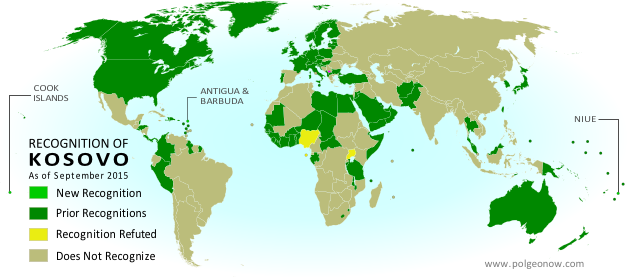
        Kosovo did a little better, winning recognition from two UN member countries: Suriname and Singapore. In 2015, one UN member country and two non-members recognized Kosovan independence, so by the numbers, 2016 was either slightly better or slightly worse for Kosovo, depending on how you count. On the other hand, Singapore is probably the most powerful country to declare its recognition of Kosovo since at least 2013. And what’s more, both the Union of European Football Associations (UEFA) and the International Federation of Association Football (FIFA) granted Kosovo membership in 2016, qualifying it to play in European soccer matches or even compete in future World Cups.

        The Sahrawi Arab Democratic Republic (SADR), the claimed independent government of Western Sahara, saw a small uptick in official support, with Panama reinstating diplomatic relations with the disputed country after suspending them in 2013. This is the second year in a row that the only change to the SADR’s recognition has been a reinstatement from a single country.
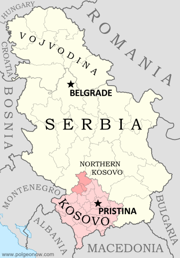
        Map of Serbia, Kosovo, and North Kosovo
        Kosovo joined FIFA in 2016

        Meanwhile UN member country Israel, which is still missing recognition from about 30 of the world’s countries, saw a renewal of diplomatic relations with Guinea, which broke relations in 1967 and was recently considered one of the countries that didn’t recognize Israeli independence. Turkey, though it already recognized Israel, upgraded its diplomatic relations with the country in 2016, after downgrading them 2011.

        Also in 2016, São Tomé and Príncipe announced it would no longer recognize the “Republic of China” government that controls disputed Taiwan, reducing the number of countries with official ties to Taiwan to just 21. Soon afterwards, São Tomé established full diplomatic ties with the People’s Republic of China (PRC), the UN-recognized government that controls Mainland China. The Gambia also established diplomatic relations with the PRC in 2016, after dropping relations with Taiwan the year before. The PRC is still missing recognition from the 21 countries that recognize Taiwan’s government instead.

        The British territory of Gibraltar also managed to win membership in FIFA in 2016, even though the organization normally doesn’t allow dependencies to join anymore.

        See all articles about diplomatic recognition
        See all articles about unrecognized or partially-recognized countries

        Intergovernmental Organizations
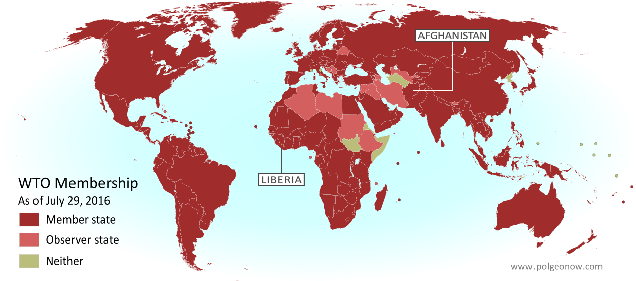
        Map of World Trade Organization (WTO) member and observer countries, updated for August 2016 to include new members Liberia and Afghanistan (labeled). Color blind accessible.
        The World Trade Organization got two new members in 2016

        The year 2016, like every year, brought many changes to countries’ membership in intergovernmental organizations:

        The biggest news about membership in international organizations was, of course, the UK’s “Brexit” vote to leave the European Union (EU), but the country is still part of the EU until it completes the withdrawal process (probably in 2018 or so). Elsewhere, Burundi, South Africa, and the Gambia announced they were withdrawing from the International Criminal Court (ICC), but because they have already ratified the treaty – unlike Russia – the law says they remain members for one more year.

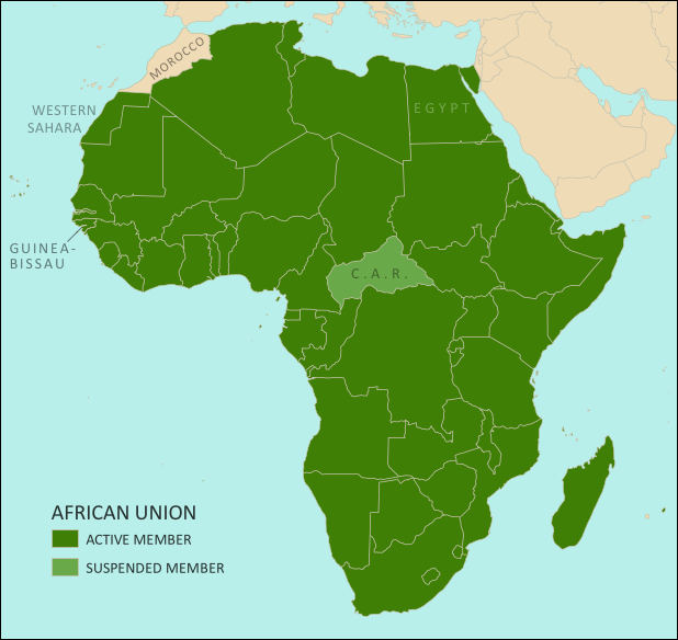
        Meanwhile, Paraguay ratified Bolivia’s membership in Mercosur, leaving only Brazil to sign on before the country can join, and Morocco applied to join the African Union (AU) in a bid that would succeed in early 2017. The disputed country of Taiwan, on the other hand, was refused entry into INTERPOL, and Cuba announced it wouldn’t try to join the Organization of American States (OAS) after the group threatened to kick out Cuban ally Venezuela. And in the gray areas between countries, Syria’s powerful Jabhat al-Nusra (Nusra Front) rebel group withdrew from international terror network Al Qaeda, changing its name to Jabhat Fateh al-Sham and promising to focus on toppling the Syrian government.
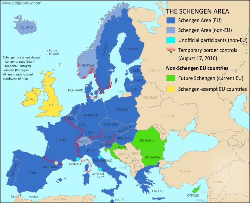
        Map of Temporarily Reintroduced Border Control in the Schengen Area (the European Union's border-free travel zone) in August 2016, color-coded for EU Schengen countries, non-EU Schengen countries, future Schengen countries, and Schengen-exempt EU countries, as well as microstates unofficially participating in the Schengen agreements (colorblind accessible).
        Reintroduced border controls in Europe’s free-travel Schengen Area

        Besides the Brexit, another political storm that dominated Europe were the cracks appearing in the continent’s free-travel Schengen Area, as member countries rushed to limit the entry of millions of Syrian and other refugees. Though threats to kick Greece out of the program never materialized, several countries did introduce “temporary” controls along borders that can normally be crossed freely. An agreement was reached in the summer to reduce the miles of border eligible for controls, but the remaining checks were still in place at the end of the year.

          See all intergovernmental organization articles

          Sea Borders and Claims

          Jurisdiction over much of the world’s ocean is still unresolved, with neighboring countries often disagreeing on where the lines fall between their respective waters, which include both territorial seas (a thin strip along the coast) and exclusive economic zones (EEZ; a much wider band where they have economic control but not full sovereignty).

          International treaty defines how much of the sea countries can claim for their own.
          (author and license information)

          The biggest maritime boundary news of 2016 was a ruling by the Permanent Court of Arbitration in the Hague, favoring the Philippines in several maritime disputes with China. China refused to participate in the case, and denounced the results as invalid, but the court’s ruling was widely considered legitimate by international law scholars, and is likely to set some legal precedents even if China never complies. The case involved the Spratly Islands and Scarborough Shoal in the South China Sea (called the “West Philippine Sea” by patriotic Filipinos), parts of which are claimed by the Philippines, China, Taiwan, Vietnam, and Malaysia.

          The court declined to rule on control of the islands themselves, saying the small pieces of land and their 12-mile territorial waters would remain disputed for now. What it did decide was that none of the Spratlys counted as a proper habitable island, meaning they don’t get their own 200-mile EEZs, and any water outside their 12-mile territorial seas but within 200 miles of other Philippine territory is the EEZ of the Philippines. It also ruled that China has no claim to any EEZ in the South China Sea beyond 200 miles from the Chinese mainland (despite the country’s “nine-dash line” claim), and that some of the Spratly reefs don’t count as land at all and are therefore part of the the Philippine EEZ.

          The decision that the islands are too small to generate EEZs could make an impact around the world, since it’s the first time a court has ruled on just how habitable an island has to be to qualify. The definition the court settled on was more strict than some had expected, excluding even islands with permanent land-based military facilities, like Taiwan-controlled Itu Aba. This precedent means many EEZs around the world could be ruled invalid in the future because the islands they’re measured from aren’t habitable enough to count.

          Elsewhere in the South China Sea, an apparently new territorial dispute popped up. China, still insisting on its unconventional “nine-dash line” claim to most of the sea’s waters and islands, announced that it had “overlapping claims” with Indonesia near the Natuna Islands. What it meant was that the nine-dash line cuts off a chunk of what would otherwise be Indonesia’s undisputed EEZ surrounding the islands.

          Map of the State of Palestine in the West Bank and Gaza Strip, including both its claimed borders (the Green Line) and zones of actual control (Area A, Area B, and Area C from the Oslo Accords)
          The Gaza Strip’s territorial waters controlled by Israel and not well defined.

          Meanwhile, in the world’s partially-recognized countries… The disputed Sahrawi Arab Democratic Republic (SADR), which claims to be the government of an independent Western Sahara (and controls a small part of it), reportedly submitted a detailed EEZ claim to the UN, including boundaries with neighboring countries. However, its claim won’t take effect anytime soon, since its entire claimed coastline is controlled by Morocco, and the UN doesn’t consider Western Sahara an independent country in the first place. Reports also spread of a coming agreement between Egypt and Palestine on their sea border, but the Egyptian government denied it. Palestine’s potential territorial sea and EEZ are currently controlled by Israel, but their boundaries aren’t well defined.

          International law also allows countries to claim rights to resources on the “continental shelf” (nearby seabed) well beyond the 200 nautical mile limit of their EEZs, but their claims have to first be registered with and approved by the UN. No new submissions came in during 2016, but the UN did approve submissions registered by Iceland, Argentina, Uruguay, and the Cook Islands (a nearly-independent country associated with New Zealand). Apparently there’s a seven-year backlog in the approval process, since all these submissions were registered in 2009.

          The approval of Argentina’s submission caused a bit of a stir, with some news headlines and Argentine officials incorrectly claiming that it endorsed Argentina’s claims over the waters of the disputed Falkland/Malvinas Islands. In fact, the UN carefully avoided ruling on those parts of the claim, only approving Argentine continental shelf rights in areas out of range of the islands. Argentina soon afterwards submitted revisions for parts of its claim, but the details haven’t been made public yet.

          See all articles on maritime borders and jurisdiction

          Provinces and States

          Though creating a new US state is a major legislative ordeal, many countries’ provinces or other divisions are created, redrawn, or abolished at will. The many changes to the world’s administrative subdivisions can be hard to keep track of, but luckily we have help from resources like the Statoids website and the ISO 3166-2 standard.

          France’s regions before 2016
          (Rosss/Wikimedia Commons CC BY-SA)

          The year 2016, for its part, kicked off with a major reorganization of France’s top-level divisions, called “regions”. As part of long-planned reforms, on January 1, 2016 France’s 22 regions were merged and consolidated into just 13. Later in the year, several of the newly-merged regions changed their names.

          Meanwhile, Mali announced that it was creating two new province-like “regions” in its northern desert, splitting off northern Timbuktu Region into Taoudenni Region, and eastern Gao Region into Menaka Region. Unlike the main cities of Timbuktu and Gao, Tuareg people form the majority in these newly-created regions, and it’s possible the reforms are intended to calm Tuareg-led groups that have long called for independence or increased self-governance in the “Azawad” area.

          France’s regions after 2016 reform
          (Chessrat/English Wikipedia CC BY-SA)

          Also in 2016, Equatorial Guinea reportedly created a new province in preparation for moving its capital to the newly-built city of Djibloho, while Mexico changed the name of its capital district from “Mexico, Distrito Federal” (DF) to just “Ciudad de Mexico” (CDMX). “Ciudad de Mexico”, or Mexico City, was already the name of the city located inside the district. The name change is part of a plan to gradually give the district more self-governance, as if it were one of Mexico’s states.

          Last year also saw the inclusion of Australian external territory Norfolk Island’s forced integration into Australia’s mainland system of governance. Many news outlets, including PolGeoNow, mistakenly reported that the territory was being merged into the state of New South Wales (NSW). In fact, the reforms put the NSW state government in charge of managing government services on the tiny island, but didn’t make it officially part of the state. In another sign of Norfolk remaining technically outside of NSW, islanders will vote in federal elections as residents of the Australian Capital Territory.

          Though neither is part of its country’s main system of subdivisions, 2016 brought an expansion to some US Indian reservations and reductions in power to Uganda’s traditional kingdoms. Tajikistan’s Gorno-Badakhshan special region also saw a decrease in self-governance, while legislators in the Philippines rejected the creation of a self-governing Bangsamoro region in the country’s Muslim-majority south, even as the president proposed turning the whole country into a federation of self-governed states like the US.

          Bangladesh created the new Mymensingh Division in 2015 (Map by NordNordWest, CC BY-SA)

          A 2015 effort by South Sudan’s president to split up the country’s 10 states into 28 remained in limbo last year, as the government and rebels struggled to find consensus on a national peace deal. India’s Assam state created two new districts before changing its mind and withdrawing their district status, but also announced the creation of a new Majuli district on a 400 sq km river island. Meanwhile, the Indian state of Manipur controversially split most of its districts in half, increasing the total number from 9 to 16.

          There were also some major changes from 2015 that only came to our attention in the past year: Bangladesh created the new province-level Mymensingh Division, tiny Luxembourg abolished one of its top-level districts, Costa Rica changed the name of one of its counties, and India’s states created several new lower-level districts (Kra Daadi and Siang in Arunachal Pradesh, and Biswanath Chariali, Hojai, West Karbi Anglong, Charaideu and South Salmara-Mankachar in Assam).

          Belarus minted its first regular-use coins in 2009, but didn’t release them until 2016.

          Currency Changes

          Unlike the previous year, no currencies died or were born in 2016. But Belarus did change the value of its money, introducing the first ever Belarussian ruble coins (other than special collectors’ coins), and both India and Venezuela ran into trouble when they rushed to replace existing paper money with newer bills.

          Part of Venezuela’s change was introducing a new 20,000 Bolivar bill, after runaway inflation reduced the value of the previous biggest note, the 100 Bolivar, to just two US cents.

          Updated map of the time zones of the world by TimeZonesBoy (click for full map and license information)

          Time Zones

          Last year saw a lot of changes to the world’s time zones – enough to fill an article of their own. So we did just that, and put together our first-ever Time Zone Changes article, with cool before-and-after maps! Check it out:

          Interactive Maps: Which Places Switched Time Zones in 2016?

          More Changes: Coastlines & Official Languages

          The shape and territory of a country aren’t affected only by where its borders are drawn, but also by the course of its coastline. And while you generally expect the beach to stay in the same place from weekend to weekend, coastlines actually are changing all the time. There are surely more small coastline changes in world than we could ever hope to keep track of, but here are a few that made the news in 2016:

          The growth of Monaco since 1861. Part of the green “Le Portier” zone is now being “reclaimed” from the sea.
          (Map by Ventic, CC BY-SA)

          In September the tiny country of Monaco approved a project to expand its land area by constructing a new neighborhood of luxury apartments, parks, and seaside facilities by filling in a small piece of the Mediterranean Sea. The new development is only six hectares (15 acres) in size, but then Monaco’s entire land area is just 2.02 square kilometers (0.78 square miles) – meaning the expansion will increase the country’s size by three percent!

          China has also been hard at work taking land from the sea, most controversially by filling in remote coral reefs to create livable islands in the disputed South China Sea – with rival claimant Vietnam following suit (see also “Disputed Territorities” and “Sea Borders and Claims” above). But China’s also been steadily expanding its coastlines on the mainland to build industrial facilities. This is probably just the biggest of many such projects going on around the world, but it’s still no Monaco: Even by upper estimates, the land reclaimed by China in recent decades only equals about one tenth of one percent of the huge country’s total land area.

          On the other end of the spectrum, Solomon Islands has reportedly been losing land area, with at least five tiny islands already lost to rising sea levels in recent years, and at least one inhabited island cut in half by related erosion.

          Technically, these coastline changes may not effect their countries’ total territorial size, since the surrounding seas were already in their territorial waters. International law is pretty clear that territorial waters don’t expand outwards when you build artificial islands and fill in coastal waters. However, it’s not completely clear whether sea territory shrinks with the disappearance of the islands or shores it’s measured from.

          Areas where Amazigh and related languages are dominant.
          (Map by P. Andries, CC BY-SA)

          Another thing that we tend to think of as a defining feature of a country is its official language or languages, and at least one country made a change to its language policy in 2016. Algeria, an Arab-majority country whose sole official tongue was Arabic until this past year (despite French being widely used in business and education), added Amazigh, or Berber, as a second official language. Berbers are the pre-Arab inhabitants of northwestern Africa, and form something a kind of indigenous group within countries like Algeria and Morocco.

          What major political geography events will happen in 2017?

          Stay tuned to PolGeoNow for lots more geography news and maps! Also, don’t forget to follow us on Twitter for extra reporting on world events, and add us on Facebook or Tumblr to get updates when new articles are published!

          Learn about more of last year’s geography changes!
          Rebel Control Around the World in 2016 
          Time Zones that Changed in 2016 
            2015: The Year in Political Geography Changes

            Premium members click here to view this article in the ad-free members area. Not a member yet? Learn about PolGeoNow subscriptions!

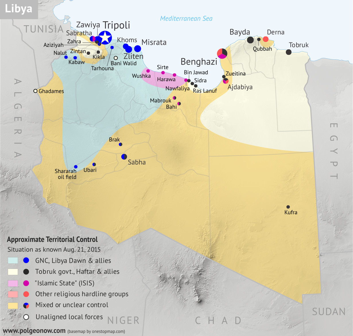
            Libya control relief map: Shows detailed territorial control in Libya's civil war as of August 2015, including all major parties (Tobruk government, General Haftar's Operation Dignity forces, and Zintan militias; Tripoli GNC government, Libya Dawn, and Libya Shield Force; Shura Council of Benghazi Revolutionaries and other hardline Islamist groups; and the so-called Islamic State). Also file under: Map of Islamic State (ISIS) control in Libya.
            Rival government and “Islamic State” (ISIS) control in Libya, August 2015 (click for free full-size map and article)

            Inside this Review of 2015:

            • New countries, breakaway states, and micronations
            • Country name, capital, and flag changes
            • Border changes and disputed territories
            • Countries joining international organizations
            • Recognition of disputed countries
            • Rebel control in conflict zones
            • Sea borders and seabed claims
            • New states and provinces
            • Currency changes
            • World time zone changes

              It’s PolGeoNow’s mission to track changes to the world’s countries, borders, and territories, whether it’s happening formally on the books or unofficially on the ground. When new countries appear, borders change, and territorial disputes arise or are settled, you’ll hear about it here. With 2015 now concluded, here’s our look back at the events of the year!

              (For extra coverage of political geography events in 2016, follow us on Twitter!)

              Declarations of Independence: New Countries in 2015?

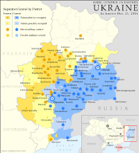
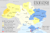
              The past year came and went without any major, credible claims of new countries. This was a big contrast to 2014, which saw declarations of independence coupled with real territorial control for Crimea, Donetsk, and Lugansk, all undisputed parts of Ukraine until then, plus the so-called “Islamic State” (formerly ISIS/ISIL) carved out of Iraq and Syria. While the Republic of Crimea ceased to exist after controversially merging into Russia shortly after declaring independence, the “Islamic State”, Donetsk, and Lugansk are still holding out today. The two Ukraine breakaways are settling into place under a long-term ceasefire, though in 2015 they gave up their aspirations of forming a united country called Novorossiya (“New Russia”).

              Map of rebel control in Ukraine in 2015, showing the areas claimed by the breakaway Donetsk and Lugansk People's Republics.
              Actual territorial control of the proclaimed Donetsk and Lugansk People’s Republics (formerly “Novorossiya”)

              While highly autonomous Iraqi Kurdistan and semi-independent Cook Islands both talked in 2015 about seeking full independence, no major moves came from either of them. In an echo of an aborted 2014 attempt at independence, rebels in the Central African Republic declared the autonomous “Republic of Logone“, but stopped short of claiming full independence. Meanwhile, in Fiji a project to carve out two anti-Muslim “Christian states” managed to be taken seriously enough for the country’s government to launch a police crackdown on the separatists.

              And as usual, the big dreamers of the world were not to be discouraged. In April, a small-time politician from the Czech Republic declared a new tax-free, bitcoin-trading libertarian country called “Liberland”. His would-be territory? A patch of technically-unclaimed land along the disputed border of Serbia and Croatia. As so-called “micronations” go, Liberland is having a pretty good run, prompting (critical) comments from established countries, accumulating tens of thousands of “citizenship applications”, and reportedly gaining recognition from 2014’s celebrity micronation – the “Kingdom of North Sudan” as claimed by an American seeking to make his daughter into a real princess.

              Map of the territorial control (Assad government, Islamic State/ISIS/ISIL, rebel, SDF, and Kurdish) in the Syrian Civil War as of December 9, 2015
              The “Islamic State” (in purple) controls much of former Syria

              As with all micronations, recognized countries are having none of Liberland’s independence claims, with its leadership repeatedly barred from entering the “country” by Serbian and Croatian authorities, who fully expect the border territory to be granted to one of them once they properly agree on their national boundary. It has also been widely denounced as a scam by other micronations, after unrealistically offering citizenship (at a hefty fee) to thousands of desperate Syrian and Libyan refugees.

              Regardless, Liberland has served as an inspiration for other would-be micronationalists: A group of Polish tourists soon after declared the state of “Enclava” in what they thought was neutral ground between Slovenia and Croatia, before being shut down by the Slovenian government and re-declaring their nation on a patch of ground near Liberland’s. Meanwhile, in June a Bulgarian businessman declared the “Principality of New Atlantis” on behalf of a floating raft of lava rock in international waters near New Zealand (which he has presumably not visited), after never hearing back from the Bulgarian government on his suggestions to annex it to Bulgaria.

              See all previous and future articles on newly declared countries

              Country Name, Capital & Flag Changes

              Just as in 2014, no official changes to country names, capitals, or flags came to our attention in 2015. However, each of those things almost happened:

              In December, the idiosyncratic dictator of the Gambia declared his country an “Islamic republic”, with some sources saying the country’s official name would be changed from Republic of the Gambia to Islamic Republic of the Gambia. However, as far as we can tell no name change has been registered formally, either with the UN or through legislation. Meanwhile, while not usually considered a “country”, the Boko Haram rebel group that controls territory in Nigeria has taken to calling itself the “Islamic State West Africa Province” (ISWAP) after purportedly joining the Syria- and Iraq-based “Islamic State” (ISIS) organization in March.

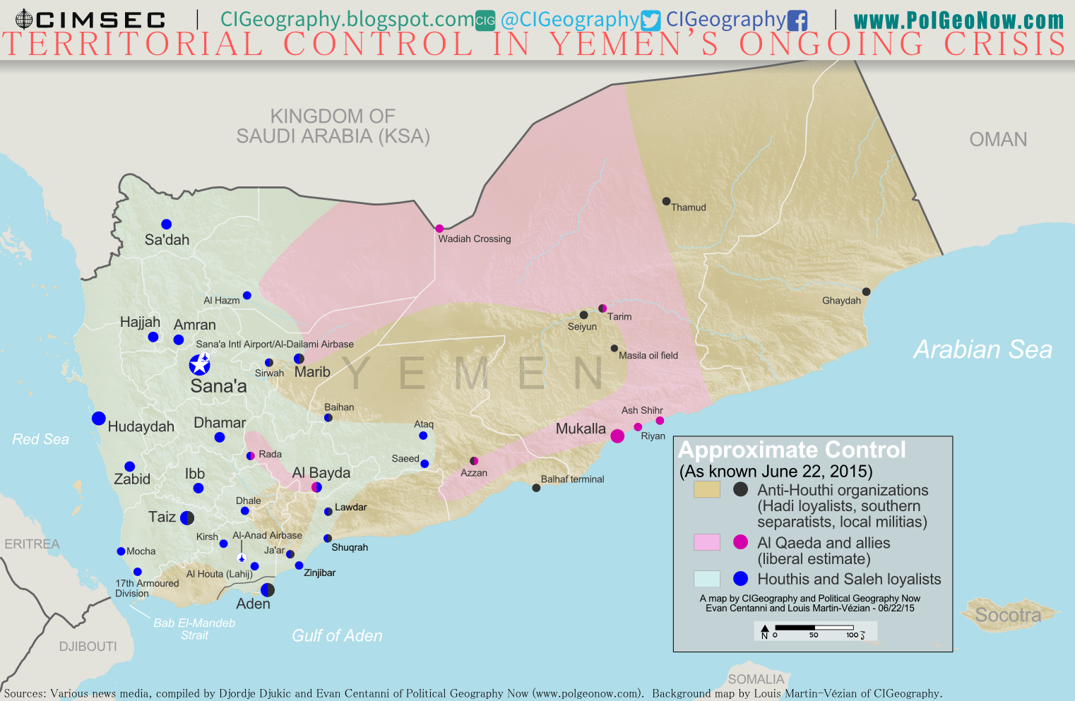
              Earlier in the year, Yemen’s internationally-recognized president declared that his capital had moved from Sana’a (currently occupied by the Houthi rebels) to the southern port city of Aden. However, this hasn’t formally come to pass either, and he may have been speaking figuratively anyway – certainly his government, if it’s currently based in Yemen at all, would for practical purposes be located in Aden for now.

              PolGeoNow maps of territorial control in Yemen

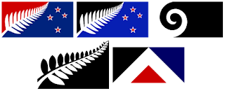
              Graphic illustrating the five flag designs up for a vote in New Zealand's November-December 2015 flag referendum: Silver Fern (Black and White), Silver Fern (Red, White and Blue), Silver Fern (Black, White, and Blue), Koru (black), and First to the Light (Red Peak)
              New Zealand voted on five proposed designs for a new flag

              There was actually quite a bit of flag news in 2015, with both Fiji and New Zealand preparing for potential changes to their flags. While Fiji’s planned flag update got delayed into 2016 pending a decision by the country’s military government, New Zealand’s democratic flag-replacement process moved forward with a nationwide referendum in November and December. In the vote, New Zealanders chose one design for the potential new flag, with the new proposal to go up against the existing flag in a second vote this March.
              We also reported in 2015 on a small change to Paraguay’s flag made two years earlierone of the many quiet flag changes that didn’t come to our attention until well after the fact.

              Everything you need to know about New Zealand’s 2015 flag referendum

              See all flag change articles on PolGeoNow

              Map of the Cooch Behar enclaves (chitmahals) traded between India and Bangladesh in 2015
              Map showing most of the Indian and Bangladeshi enclaves. By Jeroen (source). License: CC BY-SA

              Border Changes and Disputed Territories

              Summer 2015 saw a long-awaited major change to the border between India and Bangladesh, when the two countries traded over 100 enclaves (pieces of territory surrounded entirely by territory of the other country). Known as the Cooch Behar Enclaves or “chitmahals”, these “islands” of Indian territory in Bangladesh and Bengladeshi territory in India formed the majority of all the world’s national-level enclaves, but have now been mostly erased in an effort to simplify the border. Stay tuned to PolGeoNow in the near future for a full report on the border change, with a before-and-after map of the differences!

              Meanwhile, December 2015 saw the resolution of a small border dispute between Costa Rica and Nicaragua. A ruling from the UN’s International Court of Justice (ICJ) sided mostly with Costa Rica in the disagreement over administration of a small island near the mouth of the San Juan River. Niger and Burkina Faso also concluded arrangements to implement their own border deal based on another ICJ ruling from 2013 (map of the the Niger-Burkina Faso border dispute and resolution).

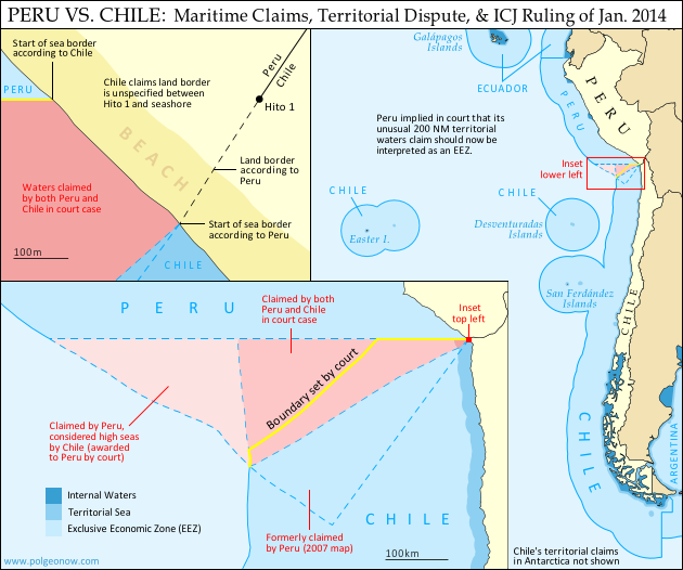
              An apparent border dispute arising between Nigeria and Benin may have been new in 2015 (PolGeoNow is currently looking into it), while Peru and Chile’s disagreement over a tiny piece of coastal land gained prominence a year after an ICJ ruling settled their adjacent sea border (map of Peru-Chile sea dispute, resolution, and remaining land dispute).

              Map of Chile and Peru's territorial waters and exclusive economic zones (EEZ), plus the details of their territorial dispute at sea and disagreement of the land border. Shows the results of the Jan. 27, 2014 ruling by the International Court of Justice (ICJ) settling the dispute.

              Meanwhile, territorial disputes over the Falkland Islands (UK-Argentina), the Senkaku/Diaoyu Islands (China-Japan-Taiwan), and the islets of the South China Sea (China-Philippines-Vietnam etc.) continued to be hot issues in 2015, while old disputes over Gibraltar (UK-Spain) and Machias Seal Island (USA-Canada) escalated slightly. A low-level territorial dispute along the coastline of India and Pakistan also made news after reports that hundreds of fisherman had been jailed for crossing carelessly or accidentally into the disputed zone.

              See Also:
              Why are the Falkland Islands so important? Map of the Falklands’ disputed seas
              Map of the uninhabited Senkaku/Diaoyu Islands, disputed between China and Japan
              Just how small are the disputed Senkaku/Diaoyu Islands? Aerial photos of each island

              See all articles on disputed territories

              Intergovernmental Organizations

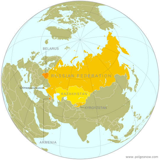
              Map of the Eurasian Economic Union (EEU), also known as the Eurasian Union. Includes new member Kyrgyzstan, as well as prior members Russia, Belarus, Kazakhstan, and Armenia, and disputed territory Crimea
              The newly founded “Eurasian Union” (free map)

              As in other years, 2015 brought many changes to countries’  membership in intergovernmental organizations:

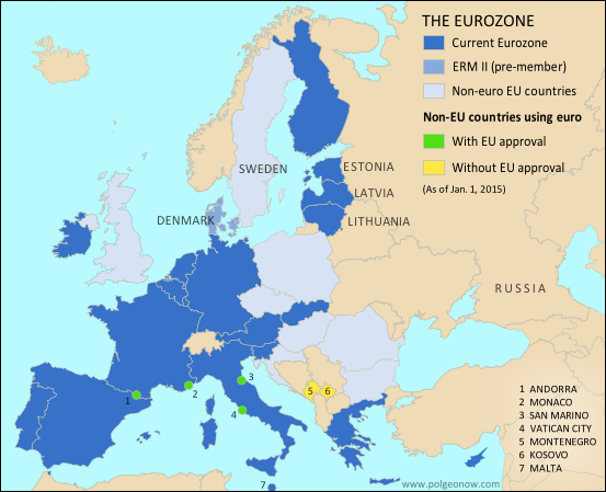
              Map of the Eurozone (euro area), showing which countries use the euro as their currency. Includes members, pre-members (ERM II), EU non-members using the euro, and other EU countries (colorblind accessible).
              Lithuania joined the Eurozone amid threats of Greece leaving (free map)

              In related news, disputed Kosovo was narrowly denied membership in UNESCO, while Bolivia was approved for membership in Mercosur, pending ratification by Brazil and Paraguay. Meanwhile, African countries agreed in principle to the creation of a massive free trade area spanning the length of the continent, while European integration degraded as some border controls in the free-movement Schengen Area were reactivated, border fences went up on the edges of the area, and (so far unrealized) fears arose that Greece would be forced to leave the Eurozone.

                See all intergovernmental organization articles

                Diplomatic Recognition

                As usual, 2015 saw several small changes in diplomatic recognition for the world’s disputed, partially recognized countries.

                Map of countries that recognize Kosovo as independent, updated for 2015.
                Map of which countries recognize Kosovo at the end of 2015 (free map)

                Kosovo received the most recognitions of any disputed country in 2015, though only narrowly, with its proclaimed independence newly acknowledged by UN member Antigua and Barbuda plus semi-independent non-UN countries Cook Islands and Niue (both loosely associated with New Zealand). This was a continued slowdown from 2014, when Kosovo received four new recognitions.

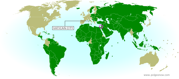
                Palestine also was only recognized by one more UN member country in 2015, the Caribbean island of St. Lucia. However, a bigger win for Palestine came from the non-UN side, when the Holy See (administration of the Catholic Church and Vatican City) clarified its own recognition of Palestine for the first time. By the numbers, this year was a slight improvement for Palestine over 2014, when it also received one UN-member recognition but nothing else. In a trend continuing from 2014, at least three more European countries’ legislatures – those of Belgium, Italy, and Greece – passed symbolic votes supporting the recognition of Palestine; however, their governments stopped short of actually extending recognition.

                Map of countries that recognize the State of Palestine as an independent country, updated for June 2015 with recent addition Vatican City (Holy See) highlighted
                Map of which countries recognize Palestine as independent
                (free map)

                The Sahrawi Arab Democratic Republic (SADR), claimed independent government of Western Sahara, saw a small uptick in official support, with African island country Mauritius reinstating recognition after “withdrawing” it the previous year. The SADR had seen a similar slight improvement to recognition in 2014, with Mauritius’s initial withdrawal offset by reinstatements from two other countries.

                In related news, the US and Cuba reestablished full diplomatic relations for the first time in half a century (though they technically already recognized each other as countries), and Palestine successfully argued that UN Observer States (currently just Palestine and the Holy See/Vatican City) should have their flags flown alongside those of UN member countries at the United Nations headquarters in New York.


                See all articles about diplomatic recognition
                See all articles about unrecognized or partially-recognized countries

                Territorial Control

                Map of Islamic State and Kurdish control in Iraq as of May 2015
                Islamic State and Kurdish control in Iraq
                (free map)

                When it came to rebel control of territory in 2015, headlines continued to be dominated by the Syrian Civil War, where rebels consolidated their power in the northwest, while Kurdish-led forces dealt significant defeats to the so-called “Islamic State” (IS, formerly ISIS) along the northern border with Turkey, even as IS fighters staged a rapid takeover of the expansive but sparsely-inhabited Syrian Desert region. A tiny Turkish enclave in Syria, the Tomb of Suleyman Shah, was also moved by Turkey to avoid damage from IS forces. In neighboring Iraq, changes to territorial control were fewer and farther between, with major events including the government recapture of Tikrit, and the loss of Anbar provincial capital Ramadi to IS, followed by its recapture at the end of the year.

                Map of territorial control in Yemen as of June 22, 2015, about two months into Saudi Arabia's military intervention, including territory held by the Houthi rebels and former president Saleh's forces, president-in-exile Hadi and the Southern Movement, and Al Qaeda in the Arabian Peninsula (AQAP).

                PolGeoNow also began renewed coverage of Yemen in 2015, as the Houthi rebels expanded their power beyond the capital city of Sana’a and all the way to the southern port city of Aden, even as Al Qaeda’s local affiliate once again captured much of the country’s southeast. The intervention of Saudi Arabia and allies, in what has come to be seen as a Saudi-Iranian proxy war, successfully pushed back the Houthis from southern Yemen, but at the end of the year they were still firmly in control of the capital and many other areas. Some reports claimed that a new rebel group had seized territory across the border in Saudi Arabia itself, but the claims have so far been impossible to confirm.

                Long awaited map coverage of Libya’s new civil war also came to PolGeoNow in 2015, with our first map of control by rival governments and the “Islamic State” published for free in August. Meanwhile, fighting between Ukraine‘s government and Russia-backed separatists came nearly to a halt early in the year, with the signing of a ceasefire deal that has more or less held until today. Separatist rebels in Mali saw scattered challenges to their partial control of the country’s far north, but fighting there also largely ended after a peace deal.

                Map of Boko Haram control in Nigeria in March 2015, and the multinational offensive with Cameroon, Chad, and Niger that drove the rebels back.
                Nigeria, Chad, and Niger took back much of Boko Haram’s territory in 2015

                Nigeria, on the other hand, had a very eventful year in its fight against the Boko Haram rebels, who were purportedly accepted as an affiliate of the so-called “Islamic State”. The religious extremist group held large parts of Nigeria’s Borno and Yobe states at the beginning of 2015, but was nearly stripped of all control after a regional coalition force struck quickly from multiple directions. By late 2015, the group was thought to maintain control of only a few small towns, if anything at all. Regardless, the new President Buhari’s promise to defeat the rebels by the end of the year rang hollow, with bombings and other attacks continuing unabated.

                Meanwhile, Afghanistan has seen an upsurge in territorial control by the Taliban rebels, as well as activity from groups associated with the so-called “Islamic State”.  Most notably, Taliban fighters captured provincial capital Kunduz in late September, before withdrawing under heavy counterattacks a couple weeks later. A brand new map of territorial control in Afghanistan is in the works as you read this, so stay tuned our PolGeoNow’s coverage in the new future!

                Much of South Sudan remained contested between the government and rebels in 2015, while the country moved slowly toward a more stable peace deal, and nearby Central African Republic also saw some small changes to territorial control for its Seleka rebel group. To the east, Al Qaeda-affiliated Al Shabaab rebels continued to contest territory in Somalia and even Kenya, even as factions of their own group splintered off to join the “Islamic State” (and reportedly captured at least one town).

                Map of territorial control in Mali as of June 2015. Includes separatist rebel control (CMA, MNLA, MAA, HCUA) and locations of UN peacekeeper (MINUSMA) deployments, as well as the location of a brief takeover by Al Qaeda in the Islamic Maghreb (AQIM).

                Elsewhere in Africa, rebels continued to contest territory in southern Sudan and the country’s western Darfur region, and eastern Democratic Republic of the Congo remained under the ever-shifting control of dozens of different armed groups. Burundi and Burkina Faso saw buildings in their capitals briefly occupied by armed opposition in purported coup attempts, while Mozambique’s government continued to clash with Renamo rebels working out of isolated bases.

                In Southeast Asia’s Myanmar (Burma), decades-long fighting continued between the government and rebel groups, notably including the major territory-holding Kachin Independence Army, while a long-dormant conflict reignited with another rebel group in the Kokang region. Meanwhile, increasing organized crime in Central America’s El Salvador resulted in some describing much of the country as “under the control” of gangs, though it was unclear exactly what kind of “control” this was.

                See all articles on countries with divided territorial control 
                See all FREE territorial control maps on PolGeoNow

                Sea Borders and Claims

                Jurisdiction over much of the world’s oceans is still unresolved, with neighboring countries often disagreeing on where the lines fall between their respective waters, which include both territorial seas (a thin strip along the coast) and exclusive economic zones (EEZ; a much wider band where they have economic control but not full sovereignty). Though considerably less active than 2014, the past year continued to see its share of changes to these maritime claims.

                In the realm of friendly boundary negotiation, Barbados agreed on an official sea border with St. Vincent and the Grenadines, while the Philippines and disputed Taiwan resolved a fisheries conflict with a cooperation agreement, but stopped short of defining a formal international boundary. [Update 2016-02-26: France and Italy also signed an important, but under-reported, treaty to define their sea border in the Mediterranean.]

                International treaty defines how much of the sea countries can claim for their own.
                (author and license information)

                International law allows countries to claim rights to resources on the “continental shelf” well beyond the 200 nautical mile limit of their EEZs, and many countries were still in the process of doing so in 2015. Early in the year, Russia submitted its formal claim to an area of seabed under the North Pole, after earlier making a more modest claim in the Arctic Ocean (Denmark, via autonomous Greenland, submitted its own claim to the North Pole seabed a few months before). Brazil also submitted a formal claim to an area of seabed in the South Atlantic, and while 2009 Pakistan’s claim to part of the Arabian Sea bed was officially endorsed by the UN body that regulates continental shelf claims.

                However, not all interaction related to the seas this year was friendly. Among other events, a long-standing dispute over the Caribbean waters off Venezuela and Guyana began to get nasty, Somalia and Kenya talked tough over a pending court case to resolve their sea boundary, and Libya accused Italy of violating its territorial waters.

                See all articles on maritime borders and jurisdiction

                Provinces and States

                Though creating a new U.S. state is a major legislative ordeal, many countries’ provinces and other divisions are created, redrawn, or abolished at will. The many changes to the world’s administrative subdivisions can be hard to keep track of, but luckily we have the wonderful Statoids website to help with that.

                The newly created provinces of Nepal
                Map by Aotearoa (source; CC BY-SA)

                In 2015, Italy, Morocco, Nepal, and the UK region of Northern Ireland all conducted complete overhauls of their subnational divisions, replacing old provinces or equivalents with new systems of administrative units. The Democratic Republic of the Congo also nearly doubled its number of provinces in a major reform, while the president of civil war-stricken South Sudan controversially announced that he was nearly tripling the country’s provinces (however, the move met with heavy opposition and probably hasn’t gone into effect).

                Additionally, the Negros Island Region became the Philippines’ 18th region (a division above the province level), and Rumonge became the 18th province of Burundi. Just before the beginning of the year, Taiwan’s Taoyuan County was upgraded to become the disputed country’s sixth province-level “special municipality”, and renamed Taoyuan City (previously the name of one of its subdistricts).

                The new Negros Island Region of the Philippines. Map by Roel Balingit (source) CC BY-SA

                In the world of sub-province-level divisions, there are almost certainly many changes that slipped through without being noticed in 2015, but there are a few we heard about: France shuffled around its some of its districts, Luxembourg merged two of its “communes” (something like a township), and Peru created a new district in a tiny patch of land disputed with Chile (left with unclear status after the two countries settled a territorial sea dispute in court).

                Meanwhile, in the US, the state of South Dakota’s Shannon County changed its name to Oglala Lakota County to better represent its indigenous population, and Alaska’s Wade Hampton Census Area (a statistical unit equivalent in scale to a county) had its name changed to Kusilvak Census Area. Wade Hampton was a pro-slavery politician in the US South who only had the region named after him because his son-in-law served as a judge in a nearby Alaska town.

                Though not technically an administrative subdivision, we’d be remiss not to mention the Kooki Chieftanship’s secession from the Buganda Kingdom – the two being semi-official traditional monarchies within Uganda, exercising limited local powers.

                Currency Changes

                The Zimbabwe dollar was retired after losing most of its value

                The past year brought one major change to the world’s money system: The Zimbabwe dollar was formally demonetized at the end of September, meaning that it’s been erased from the list of currencies used as legal tender in the world’s countries. Zimbabwe had already been phasing out its dollar for some time, in favor of more stable foreign currencies.

                Time Zones

                Several changes to the world’s time zones happened in 2015. First, Mexico created a new time zone for the state of Quintana Roo, moving the clocks in tourist resort-town Cancun one hour forward to match US Eastern Time, where many of the state’s visitors originate.

                Then, North Korea added a whole new time zone to the world map, setting its clocks back 30 minutes from South Korea and Japan, to become the only place where standard time is 8 1/2 hours ahead of UTC (formerly Greenwich Mean Time). Meanwhile, Australia deleted a world time zone when it approved a time change for the tiny territory of Norfolk Island, once the only place in the world at +11 1/2 hours, which is now at +11 along with much of the Melanesia region. It also aligns with southeastern Australia part of the year, when some provinces go forward an hour for Daylight Savings Time while Norfolk keeps its clocks the same.

                Updated map of the time zones of the world by TimeZonesBoy (click for full map and license information)

                Chile also effectively changed its time zone by deciding to never end Daylight Savings Time (DST), leaving it at -3 hours for the whole year instead of switching back to -4 in the winter (distant Easter Island, also part of Chile, will stay at -5 hours instead of switching back to -6).

                Meanwhile, Uruguay is also now permanently at -3 after abolishing DST, which used to move it ahead to -2 in the summer. Mongolia, for its part, reintroduced DST after a history of switching back and forth, while the British Caribbean territory of the Cayman Islands introduced DST for the first time.

                In other time zone changes, the US town of Metlakatla switched from Pacific Time (-8) to Alaska Time (-9), while the Canadian town of Fort Nelson switched from Pacific Time (-8) to Mountain Time (-7). Turkey and Palestine changed the dates that Daylight Savings Time was in effect, and Egypt planned to observe DST in 2015, but changed its mind in the face of public opposition.

                What major political geography events will happen in 2016?

                Stay tuned to PolGeoNow for quality maps and reporting! Also, don’t forget to follow us on Twitter for extra reporting on world events, and add us on Facebook or Tumblr to get updates when new articles are published!

                  2014: The Year in Political Geography Changes

                  Premium members click here to view this article in the ad-free members area. Not a member yet? Subscribe now!

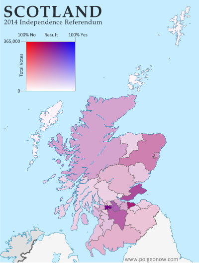
                  Map of voting results in Scotland's 2014 independence referendum, modified to show the effects of population differences between Scotland's regions
                  Scotland said “NO” to independence in a close vote last September.

                  Inside this Review of 2014:

                  • New countries & breakaway states
                  • Membership in international organizations
                  • Recognition of disputed countries
                  • Territorial disputes
                  • Rebel control
                  • Sea borders and seabed claims
                  • New states and provinces
                  • Changes to world time zones
                  • And more!

                  PolGeoNow’s mission is tracking changes to the world’s countries, borders, and territories, whether it’s happening formally on the books or unofficially on the ground. When new countries appear, borders change, and territorial disputes arise or are settled, you’ll hear about it here. With 2014 now concluded, here’s our look back at the major events of the year!

                  (Note: For extra coverage of political geography events in 2015, follow us on Twitter!)

                  Declarations of Independence: New Countries in 2014?
                  Scotland passed up its chance to become the year’s only fully-recognized new country, but 2014 saw no shortage of attempts at independence. Catalonia held a non-binding vote on separation from Spain, and separatists in Venice conducted a large-scale online poll on leaving Italy, but both were symbolic attempts that saw little participation from opponents.

                  See Also: What would have happened if Scotland voted to leave the UK?

                  Map of rebel control in Ukraine, showing the areas claimed by the breakaway Donetsk and Lugansk People's Republics.
                  Actual territorial control of the “Donetsk People’s Republic” and “Lugansk People’s Republic”

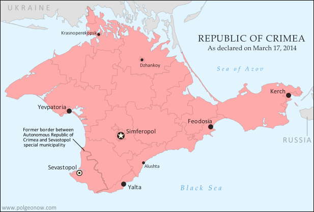
                  The most successful declaration of independence in 2014 was that of Crimea, where rebels and Russian troops overthrew the local administration and declared independence from Ukraine. Official diplomatic recognition from Russia lent this “Republic of Crimea” a brief boost in official status, putting it roughly on par with established breakaway Northern Cyprus (which is recognized only by Turkey, and came about in a similar manner 40 years ago). However, Crimea’s new administration claimed sovereignty for less than a week before voluntarily merging into Russia.

                  See Also: Was Crimea Really a Country?

                  The Ukraine conflict has also seen the emergence of two more aspiring countries, the Donetsk People’s Republic and Lugansk People’s Republic, sometimes unified as “Novorossiya“. Neither is recognized by any other country (except fellow breakaway South Ossetia), but extensive territorial control lends their claims a degree of fact, if not official diplomatic status.

                  Map of territorial control in Iraq by the Islamic State and Kurdish Peshmerga, as of August 2014.
                  The “Islamic State” took over much of northern Iraq in 2014.

                  Not to be forgotten is the so-called “Islamic State“, declared in June by the extremist rebels formerly known as the “Islamic State of Iraq and al-Sham” (ISIS or ISIL). The group began seizing full control of populated territories in late 2013, and by the end of 2014 they controlled an enormous chunk of former Syria and Iraq. Claiming to be the modern “caliphate” (empire of all Muslims), the Islamic State is in some sense an independent country of its own, despite fierce objections from the international community and many of its own would-be “citizens”.

                  Rebels in Nigeria and Libya attempted to piggyback on the Islamic State’s success by speaking of “caliphates” and “emirates” (small kingdoms), but it remains to be seen how serious they are about formal independence. Meanwhile, a rebel independence claim in the Central African Republic fizzled out after the group’s own leadership declined to endorse it. Though each serious in its own way, Greenpeace’s declaration of a “Glacier Republic” in Chile, a U.S. man’s quest to make his daughter a North African princess, and several symbolic independence declarations by Australian aboriginal peoples were all ignored completely in diplomatic circles.

                  See all articles on newly declared countries

                  Country Name & Flag Changes
                  Unlike in 2013, no existing countries seem to have changed their official names last year. Nor have any flag changes come to our attention, though it often takes some time for small flag modifications to reach our ears.

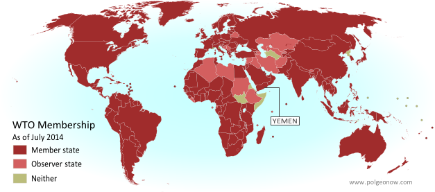
                  Map of World Trade Organization (WTO) member and observer countries, updated for July 2014 to include new member Yemen
                  The World Trade Organization got a new member in 2014.

                  Intergovernmental Organizations
                  The year 2014 saw many changes to membership in intergovernmental organizations, with these being the most prominent events:

                  See all intergovernmental organization articles

                  Diplomatic Recognition
                  Other than Crimea (see above), several of the world’s other partially recognized countries also saw changes in recognition in 2014.

                  Map of countries that recognize Kosovo as independent, updated for 2014.
                  Kosovo is now recognized by every country in Oceania.

                  Kosovo still led the pack in diplomatic recognitions, with four more countries recognizing it as independent from Serbia, though that’s down 50% from the eight recognitions it received in 2013. Palestine only received one diplomatic recognition (down from two in 2013), but it was an important one: European Union member Sweden.

                  Western Sahara saw no net change in its number of active recognitions, with Mauritius “withdrawing” recognition and Paraguay’s recognition “suspended“, but Kenya and Malawi apparently resuming theirs. Withdrawing or suspending recognition is a legal gray area, since recognition of a country (as opposed to a particular government of that country) is usually considered irrevocable. However, Tuvalu did something similar in 2014 as well, backpedaling on its 2011 recognition of Abkhazia and South Ossetia (both of which claim independence from Georgia).


                  See all articles about diplomatic recognition

                  Map of the so-called Republic of Crimea, which briefly declared independence in 2014 before merging into Russia.
                  Crimea is now disputed between Ukraine and Russia.

                  Disputed Territories on Land
                  The biggest change to the world’s territorial disputes in 2014 was the creation of a major new disputed territory: Crimea. This region was universally recognized as part of Ukraine at the beginning of the year, but after a swift military campaign in March, it’s now a territory administered by Russia and claimed by Ukraine.

                  In addition to Crimea, Russian president Vladimir Putin hinted at another new territorial dispute, suggesting that all of eastern and southern Ukraine, which he referred to by the historical term “Novorossiya” (“New Russia”), should really be part of his own country. Elsewhere, local disputes arose during the process of marking out the border between Nigeria and Cameroon, while Iraq and Iran agreed to put to rest a border dispute over the Shatt al-Arab river mouth.

                  Map of the Senkaku/Diaoyu Islands, disputed between Japan and China
                  The Senkaku/Diaoyu Islands

                  Beyond Crimea, China dominated the list of high-tension disputes in 2014, facing off with Vietnamese and Philippine forces in the South China Sea, and sending troops into an area disputed with India, but joining with Japan in a cooling of 2013’s heated jockeying over the Senkaku/Diaoyu islands. India, however, saw even greater border strife in the long-disputed Kashmir region, which saw the worst fighting in a decade between Indian and Pakistani forces.

                  Another notable development affected one of the world’s more unique territorial disputes: landlocked Bolivia’s assertion that Chile owes it land with a coastline – any land with a coastline (Bolivia claims no specific rightful border). In 2014, Bolivia took Chile to the International Court of Justice over the claim, and Chile appears to be cooperating, feeling that the facts are heavily in its favor. However, the verdict could take years to arrive.

                  See all articles on disputed territories

                  Territorial Control

                  Map of Boko Haram rebel control in Nigeria in 2014.
                  Boko Haram now controls parts of Nigeria.

                  As mentioned above in “Declarations of Independence”, 2014 saw the seizure of major areas of Ukraine, Iraq, and Syria by rebel groups. Beyond those three cases, the next most-reported was perhaps Nigeria, where Boko Haram rebels made a spectacular resurgence after having lost territory they briefly controlled in 2013. The group now controls more territory than ever before, and is having a degree of success holding it against the Nigerian government.

                  Though less heard-about, what happened to Libya in 2014 was in some ways even more dramatic. Although the government had only kept tenuous control of the country since the revolution in 2011, with local militias providing security in most places, last year the country fell apart in earnest. By the end of 2014, the militias had aligned into several opposing coalitions, with the internationally-recognized government exiled from the capital in Tripoli to a smaller city near the border with Egypt. (Coming Soon: Stay tuned to PolGeoNow for an all new map of territorial control in Libya!)

                  Map of rebel control in South Sudan's civil war as of February 2014
                  South Sudan spent 2014 split by civil war.

                  South Sudan also saw a major increase in rebel control, as the civil war that began in late 2013 reached its peak a couple months later. Meanwhile, Yemen‘s Houthi rebels, who have administered the country’s far northwest for years, advanced as far as the national capital of Sanaa. Separatists in northern Mali also claimed to recapture some towns in 2014, but negotiations are ongoing, and there was no repeat of their major takeover in 2012. Conflicts in the divided countries of Somalia, Sudan, the Democratic Republic of the Congo, and the Central African Republic dragged on into 2014, with major areas of each remaining under rebel control, while a similar situation prevailed in Myanmar (Burma).

                  There were major events in the claimed State of Palestine during the past year as well, with the West Bank and Gaza Strip nominally reunited in a peace deal between rival political parties Fatah and Hamas, but parts of the Gaza Strip temporarily re-occupied by Israel during a war between Hamas and that country. Overflow from the year’s major conflicts also saw small-scale seizures of territory in Lebanon by Syrian rebels, and in Cameroon by Boko Haram rebels from Nigeria. It was less clear whether activity by rebels in Mozambique and anti-cartel vigilantes in Mexico constituted real territorial control.

                  See all articles on countries with divided territorial control

                  Sea Borders and Claims
                  Jurisdiction over much of the world’s oceans is still unresolved, with neighboring countries often disagreeing on where the lines fall between their respective waters, which include both territorial seas (a thin strip along the coast) and exclusive economic zones (EEZ; a much wider band where they have economic control but not full ownership). However, 2014 was a relatively big year for settling these maritime boundaries.

                  Map of Chile and Peru's territorial waters and exclusive economic zones (EEZ), plus the details of their territorial dispute at sea and disagreement over the land border. Shows the results of the Jan. 27, 2014 ruling by the International Court of Justice (ICJ) settling the dispute.
                  Peru and Chile’s maritime dispute was settled in court.

                  In January, a long-standing dispute between Chile and Peru was resolved by an International Court of Justice (ICJ) ruling, in a partial compromise that largely favored Peru (in-depth map and report). A similar dispute between India and Bangladesh was settled at the Permanent Court of Arbitration in July, with the ruling mostly favoring Bangladesh.

                  Meanwhile, a number of countries signed treaties to resolve their own sea border issues. Germany and the Netherlands agreed to jointly govern a long-disputed bay,  Lithuania settled its final undefined sea border with Sweden, and the Philippines and Indonesia drew the line through a once-disputed area of sea between their respective islands. The Netherlands also signed a boundary treaty with Caribbean island country St. Kitts and Nevis (which lies close to the Dutch island of Sint Eustatius), and long-overdue boundary treaties were signed by Ecuador and Costa Rica (see map below) as well as Russia and Estonia.

                  Map of Ecuador and Peru's territorial seas as claimed in 2011, showing neighboring countries' territorial seas and exclusive economic zones.
                  Ecuador and Costa Rica’s outlying islands share a maritime boundary (2012 map)

                  International law allows countries to claim rights to resources on the “continental shelf” well beyond the 200 nautical mile limit of their EEZs, and many countries were still in the process of doing so in 2014. Toward the end of the year, Greenland and its patron country Denmark made news by formally claiming a large area of seabed under the North Pole, in what will likely lead into a dispute between several arctic countries. Formal continental shelf claims were also filed by the Bahamas, Tonga, and Somalia, while Spain and France submitted claims connected to their outlying islands in the Atlantic.

                  The West African countries of Cabo Verde, The Gambia, Guinea, Guinea-Bissau, Mauritania, Senegal, and Sierra Leone made a single joint submission of their claim to the UN, defining the seven countries’ collective continental shelf without saying where the lines between each country’s piece would be drawn. The UN commission that administers continental shelf claims stamped its final approval on a 2009 claim by Ghana and partial claims by Russia and Denmark.

                  See all articles on maritime borders and jurisdiction

                  Provinces & States
                  Though creating a new U.S. state is a major legislative ordeal, some countries’ provinces and other divisions are created, redrawn, or abolished at will. The many changes to the world’s administrative subdivisions can be hard to keep track of, but luckily we have the wonderful Statoids website to help with that.

                  In 2014, Crimea took the spotlight for subdivision changes as well as other political geography categories, with rebels declaring the region independent from Ukraine, then with Russia creating two new subdivisions to accommodate Crimea’s merger with that country. But India also made news with the creation of a new state, Telangana, while Panama, Egypt, Mauritania, and Montenegro all created new provinces or equivalent divisions. Bahrain also eliminated one of its provinces, while the nearly-independent Kurdistan created a new province within Iraq.

                  Time Zones

                  Map of political divisions in Ukraine in early 2014, including Euromaidan occupations as well as the later wave of anti-maidan occupations that would lead to the civil war.
                  In Ukraine’s 2014 political strife, not even the clocks were safe.

                  The past year also saw some changes to the world’s time zones. After controversially joining Russia, Crimea switched from Eastern European Time to Moscow Standard Time, setting clocks two hours forward to account for its simultaneous time zone switch and exit from daylight savings time (DST). Not long afterwards, Russia overhauled its whole time zone system, returning to its pre-2011 system of 11 zones (from 2011 to 2014 there were only nine zones) and changing the practice of seasonal time changes. Eastern Ukraine’s self-declared Donetsk and Lugansk People’s Republics also followed suit with Crimea, though their change (like Crimea’s) may not be recognized by the Ukrainian government.

                  Papua New Guinea also added a new time zone, with its eastern island of Bougainville jumping forward an hour to sync with neighboring Solomon Islands. The British Caribbean territory of Turks and Caicos decided to stay permanently in daylight savings time from 2014 onward, and Egypt reinstated DST after a three-year break, but with a temporary suspension during the Muslim holiday of Ramadan. Meanwhile, a number of countries adjusted their dates for the annual beginning and ending of DST.

                  What major political geography events will happen in 2015?
                  Stay tuned to PolGeoNow for quality maps and reporting! Also, don’t forget to follow us on Twitter for extra reporting on world events, and add us on Facebook or Tumblr to get updates when new articles are published!

                    Crimea Joins Russia, Gives Up Independence, Becomes Disputed Territory

                    Premium members click here to view this article in the ad-free members area. Not a member yet? Subscribe now!

                    Map of the claimed Republic of Crimea, which briefly declared independence from Ukraine on Mar. 17 before being annexed by Russia
                    The claimed Republic of Crimea which has now joined Russia (click to see full-sized map). By Evan Centanni, based on this blank map.

                    By Evan Centanni

                    Russia Annexes Crimea
                    The Crimean peninsula, which declared independence from Ukraine ten days ago as the Republic of Crimea, has now been absorbed into Russia. This was part of the plan all along – the claimed Republic of Crimea had requested to join Russia at the same time that it declared independence.

                    Related: Complete Map of Locations Seized by Russia in Crimea (Premium)

                    Once Russia had recognized Crimea as an independent country, Russian president Vladimir Putin then argued all that was necessary for his country to absorb the region was a treaty between the two supposedly sovereign states. The unification treaty between Crimea and Russia was signed on Mar. 18, the day after the peninsula’s declaration of independence. The treaty went into full effect on Mar. 21 after it was ratified by both houses of the Russian parliament and formally signed into law by Putin.

                    See Also: Crimea Declares Independence: Is It Really a Country? 

                    Geographical Implications

                    Flag of Crimea Territory Name:  
                    • Crimea (English)
                    Krym (Russian, Ukrainian)
                    Qırım (Crimean Tatar)
                    Claimants: 
                    • Ukraine
                    • Russia
                    Actual Control: Russia
                    Status: Federal subject of Russia (Republic of Crimea)/federal city (Sevastopol)
                    Capital: Simferopol/Sevastopol

                    Crimea’s annexation by Russia brings about several simultaneous changes to the world’s political geography situation:

                    Besides those country-level changes, there has also been an adjustment to the subnational administrative status of Crimea. Ukraine’s Autonomous Republic of Crimea and the special municipality of Sevastopol, which united to claim independence as the Republic of Crimea, have now been separated again as divisions within the Russian Federation. The former Autonomous Republic of Crimea is now the Republic of Crimea, a federal subject of Russia, and Sevastopol is a “city of federal significance” (also a type of federal subject within the Russian Federation).

                    Transitioning Between Two Countries
                    Russia’s annexation of Crimea may look complete on paper, but changing the whole region from Ukrainian to Russian administration is going to be a major logistical headache. In addition to the issues of distributing Russian citizenship to all Crimeans and figuring out what to do with members of the Ukrainian military who are stationed there, infrastructure will be a major issue.

                    Crimea has no land link to the rest of Russia, so new bridges and pipelines will need to be built if the region isn’t going to remain heavily dependent on Ukraine. There will also be a major stir-up to the communications system as telephone area codes are completely replaced to fit into Russia’s system. An extra digit will also need to be added to postal codes, and clocks will be permanently set two hours forward this Sunday to switch to the same time zone as Moscow.
                     

                    Map of Russian seizures and military actions in the Crimea region which it recently annexed from Ukraine.

                    Also check out our premium map report: 
                    Complete Map of Locations of Russian Seizures or Attacks in Crimea

                    More Related Articles:
                    Ukraine Crisis Overview Map: Occupations, Autonomy, & Invasion (Premium)
                    How Sharply Divided is Ukraine, Really? Honest Maps of Language and Elections

                    Graphic of the Crimean flag  is in the public domain (source).

                    Crimea Declares Independence: Is It Really a Country?

                    On Monday, two regional governments on the Crimean Peninsula controversially declared their independence from Ukraine as the new Republic of Crimea. While the declaration has been rejected by most of the world community, and Crimea hopes to swiftly unite with Russia, for now it might be considered a de facto sovereign state. Read on for details.

                    Map of the newly declared independent Republic of Crimea, seceding from Ukraine to join Russia (colorblind accessible).
                    The Republic of Crimea. Map by Evan Centanni, based on this blank map.

                    Premium members click here to view this article in the ad-free members area. Not a member yet? Subscribe now!

                    By Evan Centanni

                    Declaration of Independence
                    Following Ukraine’s revolution, the explosion of pro-Russian protests in the east, and the subsequent occupation of the Crimean peninsula by Russian forces (see our premium report, Ukraine Map: Occupations, Autonomy, & Invasion), a new independent country has been declared on the coast of the Black Sea.

                    The Republic of Crimea’s declaration of independence (English translation) was actually adopted on March 11, but was not to go into effect until and unless endorsed by this Sunday’s popular referendum. Yet sure enough, Crimea’s population, more than half of whom identify as Russians, apparently voted in favor of the split from Ukraine. Many minority Crimean Tatars – and possibly ethnic Ukrainians as well – planned to boycott the vote, though that still doesn’t explain the referendum’s passage by a suspiciously high 97 percent.

                    It’s difficult to verify whether the election was free and fair, as it was held under military occupation and against the will of Ukraine’s government, with European election observers refusing to participate in validating the outcome. Even some of the regional leaders who arranged it did not come to power legally within the Ukrainian constitution (though they claim the same of the current Ukrainian government in Kiev). Given all these issues, it may never be known whether a majority of Crimea’s people truly do want the split with Ukraine.

                    See Also: How Sharply Divided is Ukraine, Really? Honest Maps of Language and Elections

                    Union of Two Regions

                    Flag of CrimeaCountry Name:  
                    • Crimea (English)
                    Krym (Russian, Ukrainian)
                    Qırım (Crimean Tatar)
                    Full Name:  
                    • Republic of Crimea (English) 
                    • Respublika Krym (Russian, Ukrainian)
                    • Qırım Cumhuriyeti (Crimean Tatar)
                    Capital: Simferopol

                    A political geography detail left out of many reports is the fact that, under the Ukrainian constitution, Crimea is actually divided between two different regional governments. The majority of the peninsula falls under the jurisdiction of the Autonomous Republic of Crimea – a special regional administration with more power than Ukraine’s provinces but less power than a U.S. state. But another sizable chunk is governed by the special municipality of Sevastopol, a city which is not part of any Ukrainian province.

                    Crimea’s process of exiting Ukraine was endorsed by both the parliament of the Autonomous Republic of Crimea and the city council of Sevastopol, though as previously mentioned, both bodies are led by politicians installed under questionable circumstances during the past few weeks. By agreeing to this declaration, the active governments of the two administrative areas have effectively agreed to unite into a single independent country for now.

                    Joining Russia
                    Although the process involves declaring Crimea and independent country, the goal is actually to join Russia as an autonomous republic within that country’s federal system (once united with Russia, Sevastopol will likely return to its status as a separate municipality). Accordingly, the newly declared Republic of Crimea has already applied to join the Russian Federation (i.e. Russia), and Russian president Vladimir Putin has already signed a treaty to allow Crimea’s admission. However, the treaty will need to be ratified by Russia’s parliament before Crimea can become part of the country under Russian law.

                    International Recognition
                    The key to acceptance by a new country into the international community is diplomatic recognition from other countries. Given the way it came about, Crimea is unlikely to receive recognition from many of the world’s states. However, it has already joined the club of breakaway states with at least one recognition, after its independence was officially acknowledged by Russia. An independent Crimea has also apparently been endorsed by three other mostly-unrecognized pro-Russian breakaway states: Abkhazia, South Ossetia, and Nagorno-Karabakh.

                    Is Crimea a Real Country?
                    Though most lists of the world’s countries include only those with recognition from the United Nations, other proclaimed nations can sometimes be described as de facto (“in actual fact”) independent countries if the reality on the ground shows they aren’t part of any other country. Since Crimea is clearly no longer controlled by Ukraine and is not yet claimed by Russia, it probably could be placed in this category.

                    Similar cases which are often described as de facto independent countries are Northern Cyprus, which is recognized only by Turkey, and Abzhazia and South Ossetia, which are recognized only by Russia and a few others. These claimed countries may be puppet states – under the close political influence of a neighboring nation – but through history that often hasn’t stopped countries from receiving recognition and even being members of the U.N. (think of eastern Europe during the Cold War, or Iraq and Afghanistan after the U.S. invasions).

                    A country can be de facto independent without being established through a democratic process or within the laws of the country it’s splitting from. Though unilateral declarations of independence can be tricky to trade in for diplomatic recognition these days, many modern countries were created this way, from Croatia to Bangladesh to the United States. So the questionable circumstances surrounding Crimea’s declaration and referendum don’t actually disqualify it from being considered a country.

                    In fact, the Crimean declaration of independence made specific mention of Kosovo, another claimed country which declared independence after being occupied by foreign powers – in that case, NATO intervening to protect ethnic Albanians from the government of Serbia. Though Russia has been among the strongest opponents of Kosovo’s independence, supporters of Crimea’s secession from Ukraine have been quick to point to a judgment from the International Court of Justice (ICJ) which ruled that Kosovo’s declaration of independence did not violate international law.

                    Graphic of the flag of Crimea is in the public domain (source).

                    Puerto Rico: 51st State of the U.S.?

                    [This article was written after Puerto Rico’s 2012 status referendum. In June 2017, Puerto Rico voted in another controversial referendum, again technically in favor of statehood. Most of this five-year-old article is still accurate after the 2017 vote. -Editor]

                    Earlier this month, papers reported that Puerto Rico had voted to become a state of the U.S. – but will it really happen? What does it take to become a state, anyway? Last time, we explained Puerto Rico’s current status – now for answers about the territory’s future….

                    Flag of the United States with a new star added (total of 51 stars) for a hypothetical new state of Puerto Rico
                    A possible 51-star U.S. flag. Since each star on the flag represents one state, a new one would need to be added for Puerto Rico (public domain; source).

                    Why would Puerto Rico want to become a state?
                    Puerto Rico’s current situation leaves it disadvantaged compared to the states. It has its own constitution and government, but the laws establishing them are subject to approval by the U.S. Congress. And despite the fact that most federal taxes and other laws apply to Puerto Ricans, residents have no real representation in Congress and no say in the presidential election. (For more details, see What is Puerto Rico?)

                    Is statehood the only option?
                    No – in Puerto Rico’s November 6th referendum, voters had two other choices besides becoming a U.S. state:

                    1. Full Independence – This would mean cutting all territorial ties to the U.S. and becoming the world’s newest country. However, this option is unpopular in Puerto Rico, because locals are taught from a young age that independence wouldn’t be feasible (a questionable claim).

                    2. Sovereign Free Association – In fact, this option would also officially make Puerto Rico an independent country – but it would be allowed to keep U.S. military protection and some other government services on a voluntary basis. Micronesia, the Marshall Islands, and Palau currently have this status.

                    A fourth possible option – continuing as a U.S. territory but under modified terms – was controversially left off of the ballot.

                    What would a State of Puerto Rico look like?

                    In terms of population, Puerto Rico’s 3.7 million people would make it a medium-sized state, with two senators and about five representatives in the U.S. Congress (and therefore about seven electoral votes for the president). Economically it would be the weakest of the states (though still stronger than most countries). But what it would lack in economic power, it would make up for in cultural and historical uniqueness, as the only state with a Spanish-speaking majority and the only state ever visited by Christopher Columbus. Geographically, it would be the third smallest of the states by area, and would contain both the new easternmost and the new southernmost points in the 51 states.

                    Flag of Puerto Rico Territory Name:  
                    • Puerto Rico (English, Spanish)
                    Official Name:  
                    • Commonwealth of Puerto Rico (English)
                    • Estado Libre Asociado de Puerto Rico (Spanish)
                    Capital: San Juan

                    How can a territory like Puerto Rico become a state?
                    The U.S. Constitution only specifies that new states can’t take territory from existing states without their permission, so the procedure is based largely on the Northwest Ordinance of 1787. That law set up the first organized American territory, in what’s now the Midwest, and defined the process for admitting new states.

                    To qualify for statehood, an area must have a population of at least 60,000 (no problem for Puerto Rico – there are over six times that many people just in the capital city). Then the U.S. Congress needs to pass an “enabling act” to get the ball rolling by authorizing the territory to draft a state constitution. Once it’s ready, the state is admitted through a majority vote in Congress and the President’s signature, just like any other law. That’s all.

                    Then Puerto Rico will become a state now, right?
                    Not so fast – it’s actually not clear whether the people of Puerto Rico really do want to become the 51st state. Here’s the story: the recent referendum first asked whether Puerto Rico should remain a U.S. territory like it is now, and 54% voted “no” – so far, so good. Then it asked a separate question on what the best option for change would be – on this question, 61% of the votes went for statehood (compared to 33% for free association and 6% for full independence). Statehood it is then, right?

                    Not quite. The meaning of the results is controversial, because many people left the second question blank, and if you include them, statehood only had 45% support. And even if you don’t count the blank votes, 61% of the people who chose change on the first question would still add up to less than 50% of the total voters. On top of all this, the territory’s pro-statehood governor was voted out on the same day, in favor of a candidate who supports the status quo. And it’s been suggested that even a real 50% wouldn’t be enough to fairly count as a mandate, since joining the union is basically irreversible (the last time any state tried leaving, lots of people died).

                    So, will it happen or not?

                    Probably not. In principle, President Obama has said he would support Puerto Rican statehood if the people clearly wanted it, and the opposing Republican Party wrote in their 2012 platform that they would support it too. But since the will of the people is anything but clear in this case, Congress reportedly has no plans to act on the referendum.

                    A statehood law admitting Puerto Rico might not pass so easily anyway: since the new state might end up voting blue, the Republicans in Congress could be reluctant to admit it after all. And in any case, the process would likely be very slow: the legislators have their hands full with other issues already, and adding a new state could lead to a long process of haggling over how to rearrange the population-based seats in the House of Representatives (they would have to either be added to or redistributed to make room for Puerto Rico).

                    Nevertheless, Puerto Rico’s pro-statehood movement is still giving it all they’ve got. The territory’s non-voting delegate to Congress, as well as the recently defeated governor, both have pushed forward in asking President Obama to get the process moving. And though it may seem like a lost cause in the short term, sources tell Political Geography Now that many Puerto Ricans are hoping statehood can at least be considered more seriously from now on.

                    Map of the whole U.S. plus Puerto Rico (red). Puerto Rico would be the southernmost and the easternmost state, and the third smallest. Map by Vrysxy (source; CC BY-SA)