Taiwan Loses “Recognition” from El Salvador (Map)

You can always find the latest version of this map, and a list of all related articles, on our Which Countries Recognize Taiwan? page.

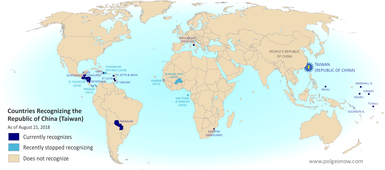
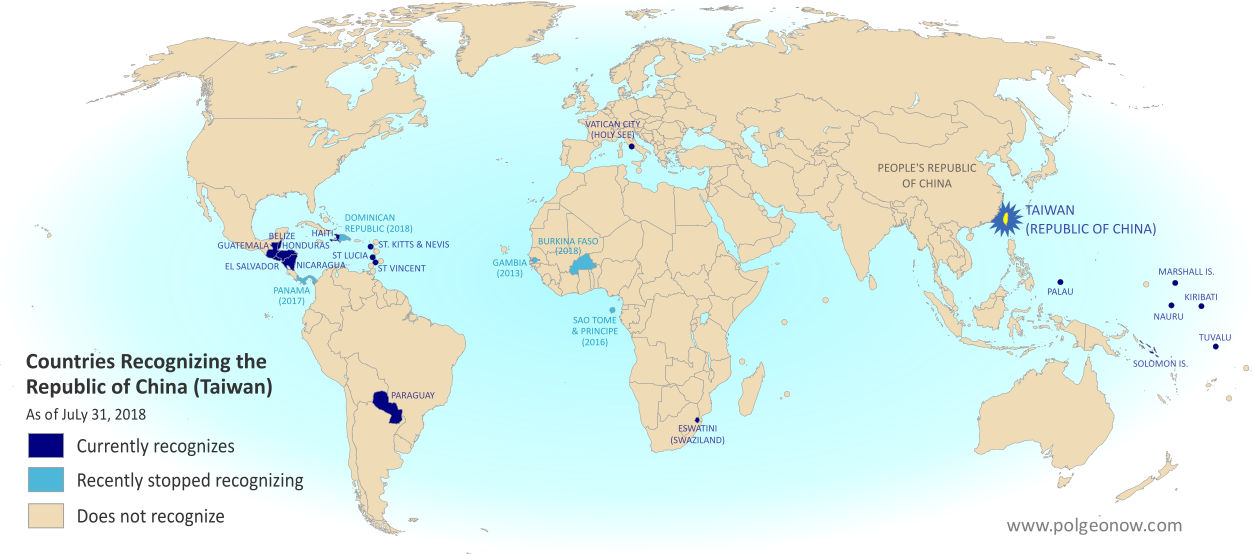
Map of who recognizes Taiwan (what countries recognize the Republic of China) in August 2018. Marks countries that have cut diplomatic ties with Taiwan (withdrawn recognition) in the last ten years: El Salvador, Burkina Faso, the Dominican Republic, Panama, Sao Tome and Principe, and the Gambia. Also answers question: Where is Republic of China located? (Colorblind accessible)
Click to enlarge. By Evan Centanni, modified from public domain blank world map.
Contact us for permission to use this map.

Article by Evan Centanni

El Salvador Drops Taiwan

Flag of the Republic of China (Taiwan) Short Name (informal):  
• Taiwan (English)
• ROC (English)
• Táiwān (Chinese)
Official Name (in constitution):  
• Republic of China (English)
• Zhōnghuá Mínguó (Chinese)
Other names used officially:  
• “Republic of China (Taiwan)” (government offices)
• Chinese Taipei (international sports)
• Taiwan, Province of China (used by UN without Taiwan’s input)   
Capital: 
Taipei (de facto)
Claimed by: People’s Republic of China 

Disputed Taiwan lost its official endorsement from the Republic of El Salvador today. The small but densely-populated Central American country is cutting ties with Taiwan’s government in favor of setting up relations with Mainland China, becoming the latest to endorse the Mainland’s claim that Taiwan is part of China.

In a novel twist, reports said Taiwan’s government “pre-emptively” cut ties with El Salvador just hours before the Salvadoran government publicly announced the switch. But the move was still based on a decision by El Salvador, which Taiwan officials said had been holding talks on the possibility since June.

Is Taiwan a Country?

The islands of Taiwan operate like an independent country today, but are governed under the constitution of the “Republic of China” (ROC), the government that ruled Mainland China before the country’s communist revolution (the administration that now rules the Mainland is called the People’s Republic of China, or PRC).

Since 1991, Taiwan’s government has sought recognition separate from Mainland China in the UN, without challenging the PRC’s right to the Mainland. But because the Mainland government insists Taiwan can’t be separate, it cuts ties with any countries that set up relations with Taiwan, even if they want to stay friends with China too.

“Economic Reasons”

El Salvador’s government is calling its shift away from Taiwan the only reasonable choice in a world where China is one of the most powerful economies, saying that it will bring more opportunities in the future. El Salvador has never before had diplomatic relations with the PRC. Alluding to the fact that the ROC no longer governs most of China, a Salvadoran spokesman was quoted as saying, “El Salvador can’t turn its back on international reality.”

Taiwan’s government, on the other hand, described more specific motivations. The disputed country’s foreign minister accused El Salvador’s president of asking Taiwan to fund his re-election campaign, and said the Salvadoran government had also backing for an expensive port construction project that would have left both countries in debt. (Some speculate that if China steps in to fund the port, it could eventually host the first Chinese military base in the Americas.)

Though Taiwan’s dwindling list of diplomatic contacts may not be a critical threat to its self-governing status, these changes are not merely symbolic. Even aside form the economic ramifications for El Salvador, many average people on both sides may be affected. For example, Salvadoran students in Taiwan are about to see their studies cut short, being forced to either transfer to Mainland China or return home.

Learn More: What Exactly is Taiwan, and Do Countries Really “Recognize” It?

Republic of China: Shrinking Recognition

Today, only 17 countries in the world (about 9%) still have formal diplomatic relations with the Taiwan-based “Republic of China” government – the closest equivalent to officially “recognizing” Taiwan as a country. That includes 16 United Nations (UN) member countries plus UN observer state Vatican City.

El Salvador is the fifth country to drop Taiwan since the current ROC president, whose platform involves resisting Mainland Chinese influence, took office in 2016. Before El Salvador, the last four countries to switch to China were the Dominican Republic and Burkina Faso this May, Panama in June 2017, and São Tomé and Príncipe in December 2016.

Only one country, the Gambia, abandoned Taiwan between 2008 and 2016, during a “diplomatic truce” initiated by Taiwan’s most Mainland-friendly president (even then, the PRC waited until Taiwan elected its current president before restoring its own relations with the Gambia).

Graphic of the Republic of China (Taiwan) flag is in the public domain (source).

Taiwan Loses Recognition from Dominican Republic, Burkina Faso (Map)

You can always find the latest version of this map, and a list of all related articles, on our Which Countries Recognize Taiwan? page.

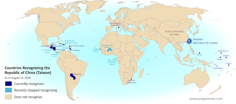
Map of who recognizes Taiwan (what countries recognize the Republic of China) in July 2018. Marks countries that have cut diplomatic ties with Taiwan (withdrawn recognition) in the last ten years: Burkina Faso, the Dominican Republic, Panama, Sao Tome and Principe, and the Gambia. Also answers question: Where is Republic of China located? (Colorblind accessible)
Click to enlarge. By Evan Centanni, modified from public domain blank world map.

Article by Evan Centanni

Dominican Republic, Burkina Faso Drop Taiwan

Flag of the Republic of China (Taiwan) Short Name (informal):  
• Taiwan (English)
• ROC (English)
• Táiwān (Chinese)
Official Name (in constitution):  
• Republic of China (English)
• Zhōnghuá Mínguó (Chinese)
Other names used officially:  
• “Republic of China (Taiwan)” (government offices)
• Chinese Taipei (international sports)
• Taiwan, Province of China (used by UN without Taiwan’s input)   
Capital: 
Taipei (de facto)
Claimed by: People’s Republic of China 

This past May, disputed Taiwan lost its official endorsements from both the Dominican Republic in the Caribbean, and Burkina Faso in West Africa. The two countries have cut ties with Taiwan in favor of setting up official relations with Mainland China, endorsing the Mainland’s claim that Taiwan is part of China.

The islands of Taiwan operate like an independent country today, but are governed under the constitution of the “Republic of China” (ROC), the government that ruled Mainland China before the country’s communist revolution (the administration that now rules the Mainland is called the People’s Republic of China, or PRC).

Since 1991, Taiwan’s government has sought recognition separate from Mainland China in the UN, without challenging the PRC’s right to the Mainland. But because the Mainland government insists Taiwan can’t be separate, it cuts ties with any countries that set up relations with Taiwan, even if they want to stay friends with China too.

The Dominican Republic announced it was cutting ties with Taiwan on May 1, 2018, saying the reason was “history and socioeconomic reality”. This reality allegedly includes the equivalent of $3.1 billion US dollars in investments and loans from China, though the Dominican government only mentioned future tourism opportunities as an example.

Burkina Faso followed on May 24, even though it had just co-sponsored Taiwan’s bid to become an observer at World Health Organization (WHO) meetings. The Burkinabe government also cited “socio-economic challenges” and the “evolution of the world” as the reasons for its switch.

Learn More: What Exactly is Taiwan, and Do Countries Really “Recognize” It?

Republic of China: Shrinking Recognition

Today, only 18 countries in the world (about 9%) still have formal diplomatic relations with the Taiwan-based “Republic of China” government – the closest equivalent to officially “recognizing” Taiwan as a country. Before the Dominican Republic and Burkina Faso cut ties in May, the last two countries to drop Taiwan in favor of the PRC were Panama in June 2017 and São Tomé and Príncipe in December 2016.

Only one country, the Gambia, abandoned Taiwan between 2008 and 2016, during a “diplomatic truce” initiated by Taiwan’s most Mainland-friendly president (even then, the PRC waited until Taiwan elected a more independence-leaning president before restoring its own relations with the Gambia).

Taiwan’s last remaining “diplomatic ally” in Africa is tiny Eswatini (Swaziland), whose king recently promised not to follow Burkina Faso in switching to the PRC. Supporters of a separate Taiwan worry their next loss might be the Holy See, government of the Catholic Church’s independent Vatican City in Rome. The Vatican has recently been working to patch up its bad relationship with the Mainland Chinese government.

Learn More: What’s the difference between Vatican City and the Holy See?

Graphic of the Republic of China (Taiwan) flag is in the public domain (source).

Map: Which Countries “Recognize” Taiwan?

This map and explainer will be updated whenever there’s a change to the list of Taiwan’s “diplomatic allies”. You can find articles on each change by scrolling to the bottom of this page, or by viewing all Taiwan articles on PolGeoNow.

Map of who recognizes Taiwan (what countries recognize the Republic of China) in August 2018. Marks countries that have cut diplomatic ties with Taiwan (withdrawn recognition) in the last ten years: El Salvador, Burkina Faso, the Dominican Republic, Panama, Sao Tome and Principe, and the Gambia. Also answers question: Where is Republic of China located? (Colorblind accessible)
Click to enlarge. By Evan Centanni, modified from public domain blank world map.
Contact us for permission to use this map.

Is Taiwan a Country?

At PolGeoNow we frequently report on self-proclaimed, unrecognized or partially-recognized countries – but Taiwan is a special case. It operates like an independent country today, but has never formally declared independence. Instead, Taiwan and its surrounding islands govern themselves as the “Republic of China” (ROC), under a constitution brought there by a former government of the Chinese mainland.

Flag of the Republic of China (Taiwan) Short Name (informal):  
• Taiwan (English)
• ROC (English)
• Táiwān (Chinese)
Official Name (in constitution):  
• Republic of China (English)
• Zhōnghuá Mínguó (Chinese)
Other names used officially:  
• “Republic of China (Taiwan)” (government offices)
• Chinese Taipei (international sports)
• Taiwan, Province of China (used by UN without Taiwan’s input)   
Capital: 
Taipei (de facto)
Claimed by: People’s Republic of China

Taiwan (ROC) vs. Mainland China (PRC)

Taiwan’s ROC government stands in contrast to the People’s Republic of China (PRC), which took the Mainland from the ROC in the Chinese Communist Revolution of the 1940s. The PRC government in Bejing never managed to take over Taiwan, but still insists that it will someday, saying the island is an inseparable part of China. It maintains delicate, semi-official relations with the ROC government in Taipei, but fiercely opposes any move toward formal Taiwanese independence.

Taiwan’s ROC government also claimed ownership of all China at one time, when it was ruled under martial law by Chiang Kai-shek‘s Chinese Nationalist Party (Kuomintang, or KMT). But with democracy now in place, and fewer and fewer Taiwanese people thinking of themselves as Chinese, recent administrations have backed off from those claims.

In fact, many of Taiwan’s politicians support increased acknowledgement of independence, but so far no administration has been willing to risk war with Mainland China by issuing a full-on independence declaration.

Who “Recognizes” Taiwan?

Until the 1970s, the Taiwan’s ROC government held onto China’s seat in the United Nations (UN), and was considered China’s rightful government by the majority of the world’s countries. But after the UN General Assembly deposed it and replaced it with the PRC in 1971, the tables turned quickly.

Today, only 17 countries in the world (about 9%) still have formal diplomatic relations with the Taiwan-based ROC government, including 16 UN member countries plus UN observer state Vatican City. All of them are marked on the map above, along with all countries that have cut diplomatic ties with the ROC within the last ten years.
 
Now, recognizing a government doesn’t technically have the same legal meaning as recognizing a country. Officially, everyone recognizes China as a country, but they disagree over whether the ROC or PRC administration is China’s government. That means that when we talk about countries “recognizing” Taiwan, it’s not technically the same thing as when countries recognize Kosovo or Palestine.

To illustrate that point: A country that recognizes Kosovo as a country independent from Serbia normally continues to recognize Serbia as a country too. But in the case of China and Taiwan, countries are forced to pick one or the other. Because the Mainland government insists Taiwan can’t be separate, it cuts ties with any countries that set up relations with Taiwan, even if they want to stay friends with China too.

Still, saying that a country with diplomatic ties to the ROC “recognizes Taiwan” is a useful practical analogy, since Taiwan now strives to be something more like a self-declared country than a rival government of China. In fact, after 1991 Taiwan’s government requested a seat separate from Mainland China in the UN, accepting the PRC’s right to rule the Mainland even while making sure not to declare outright independence.

North and South Korea have an arrangement just like that, both technically claiming to be governments of Korea while still allowing each other to have separate recognition and UN seats. But because the PRC sees Taiwan its subordinate, not its equal, it has blocked any similar deal from happening.

Taiwan Recognition News on PolGeoNow

Since 2017, PolGeoNow has been bringing you ongoing coverage of all events effecting the recognition of Taiwan. News articles about these changes are listed here:

Map of who recognizes Taiwan (what countries recognize the Republic of China) in August 2018. Marks countries that have cut diplomatic ties with Taiwan (withdrawn recognition) in the last ten years: El Salvador, Burkina Faso, the Dominican Republic, Panama, Sao Tome and Principe, and the Gambia. Also answers question: Where is Republic of China located? (Colorblind accessible)El Salvador Switches Recognition from Taiwan to China
Taiwan and El Salvador cut ties in August 2018, amid accusations of unreasonable Salvadoran financial demands.

Full map and article

Map of who recognizes Taiwan (what countries recognize the Republic of China) in June 2018. Marks countries that have cut diplomatic ties with Taiwan (withdrawn recognition) in the last ten years: Burkina Faso, the Dominican Republic, Panama, Sao Tome and Principe, and the Gambia. Also answers question: Where is Republic of China located? (Colorblind accessible)Taiwan Loses Dominican Republic, Burkina Faso Recognition
In May 2018, two more countries cut ties with Taiwan in favor of relations with Mainland China, both under financial pressure.

Full map and article

Map of who recognizes Taiwan (what countries recognize the Republic of China) in June 2017. Marks countries that have cut diplomatic ties with Taiwan (withdrawn recognition) in the last ten years: Panama, Sao Tome and Principe, and the Gambia. Also answers question: Where is Republic of China located? (Colorblind accessible)Panama Recognizes China, Stops Recognizing Taiwan
In 2017, the Central American republic of Panama became the second country to cut ties with Taiwan since an eight-year “diplomatic truce” between the ROC and PRC ended in 2016.

Full map and article


Graphic of the Commonwealth flag is displayed under fair use principles (source).

Philippines: No More “Islamic State” Control in Marawi

Article by Evan Centanni

(Subscribers click here to view this article in the members area.)

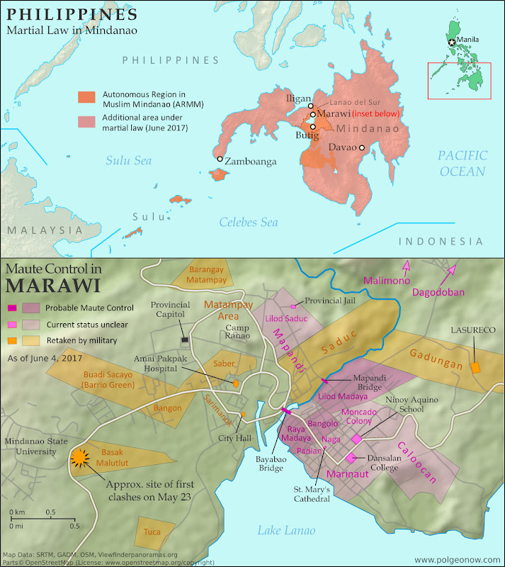
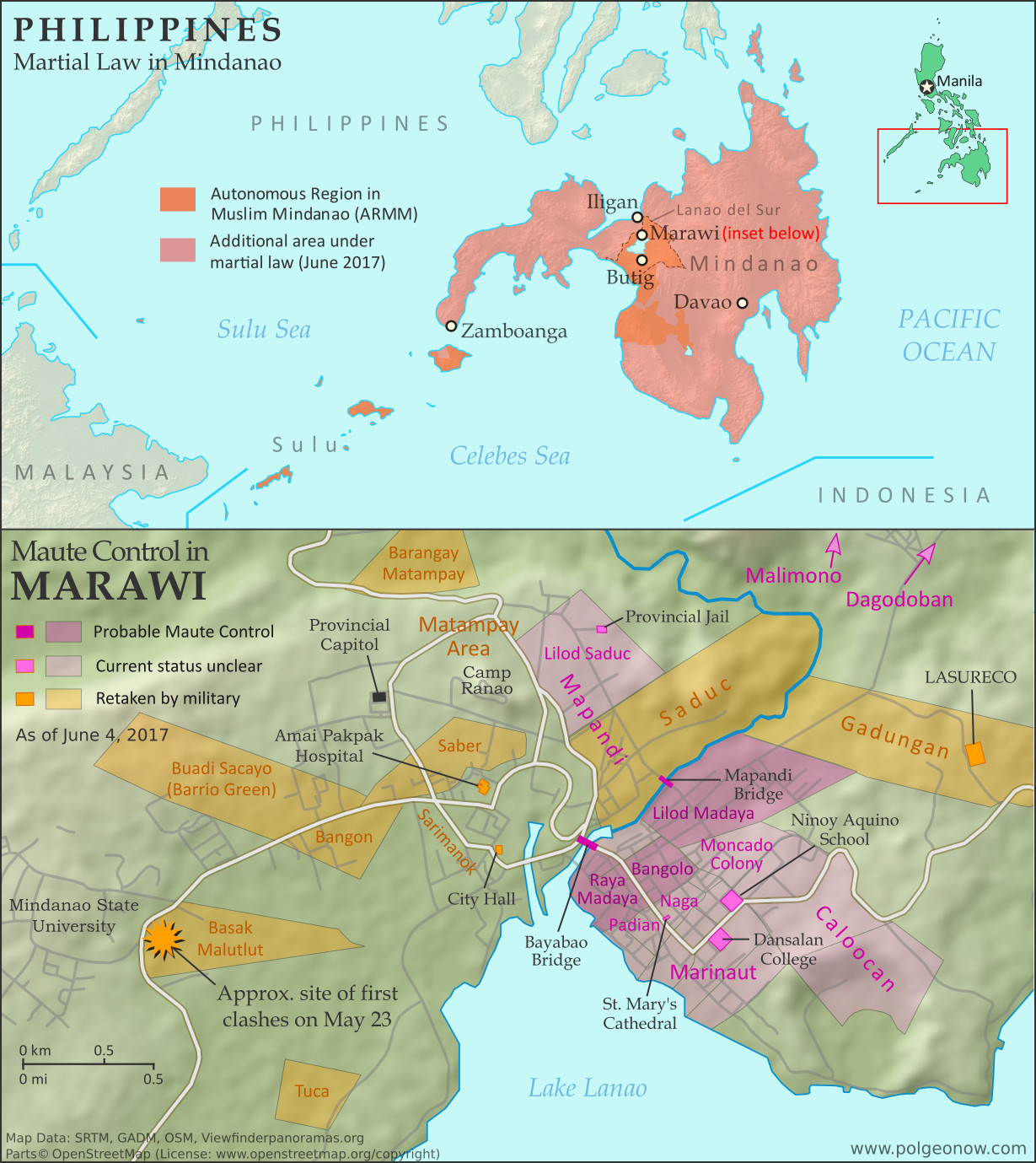
Map of so-called Islamic State (ISIS/ISIL) control in the Philippines, during the May-June 2017 crisis involving the Maute group and Abu Sayyaf takeover of Marawi Ciy, Lanao del Sur province, Mindanao. Updated to June 4, 2017, shows detailed control of Marawi by barangay. Includes map of area affected by martial law declared by President Rodrigo Duterte. Colorblind accessible.

Rebel Takeover in Southern Philippines

In early June, we published a detailed map and timeline of control in the Filipino city of Marawi, which had been partly captured by rebel fighters claiming to representing the so-called “Islamic State” (IS; formerly ISIS/ISIL). In a matter of hours, hundreds of religious hardline fighters had launched a surprise takeover of the city, led by the recently-formed Maute rebel group and Isnilon Hapilon, a leader of the radical Abu Sayyaf network and the IS’s officially designated leader for the Philippines.

The Filipino military quickly moved in to expel the fighters from Marawi, but the battle would drag on for another 5 months before the city was restored to full government control. As part of the government response, President Rodrigo Duterte declared martial law across the entire southern Philippines. For more on the history of martial law in the Philippines, and rebellions in the country’s south, see our article from June.

IS-affiliated Rebels Expelled from Marawi

The siege of Marawi City finally came to an end on October 23, exactly five months after it started, with the capture of the last rebel-held building by the Armed Forces of the Philippines. Over a thousand people had been killed in the fighting, including 165 military and police personnel, over 900 rebel fighters, and dozens of civilians. The three leaders of the insurrection, Hapilon and the two Maute brothers, were among the dead.

Flag of the PhilippinesCountry Name:  
• Philippines (English)
• Pilipinas (Filipino)
Official Name:  
• Republic of the Philippines (English)
• Republika ng Pilipinas (Filipino)
Capital: Manila

President Duterte’s martial law declaration remained in effect, having been extended by the legislature until the end of 2017. As of November, it was not yet clear whether the declaration would be extended again. The military hopes to continue its momentum in batting down other hardline rebel groups in the southern Philippines, such as the Bangsamoro Islamic Freedom Fighters (BIFF).

However, the region’s most prominent rebel force, the Moro Islamic Liberation Front (MILF), reportedly fought alongside government troops against the IS-inspired fighters. The MILF and the Filipino government had already been partway through implementing a drawn-out peace deal at the time the violence erupted in Marawi.

For a timeline of events in Marawi since our June 4 report, see Wikipedia’s well-sourced Battle of Marawi article (sources can be verified using the footnote citations for each timeline entry).

Want to know more? Read PolGeoNow’s in-depth June 2017 article on the rebel takeover of Marawi!

Graphic of the flag of the Philippines is in the public domain (source).

Why Brexit Matters: 5 Things That Might Change When Britain Leaves the EU

By Bryn Jansson

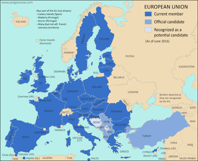
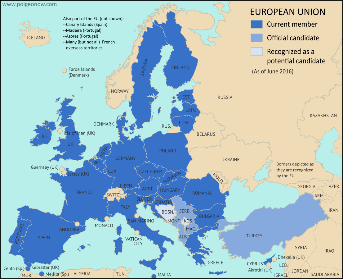
Map of the European Union, including all member countries, official candidate countries, and potential candidate countries, as 2017 (colorblind accessible).
Map of current and future EU member countries

Brexit Process Finally Begins

The United Kingdom (UK) and the European Union (EU) began formal divorce negotiations in Brussels last Monday, June 19, starting a 21-month sprint to the March 2019 Brexit deadline. (“Brexit” is short for “British Exit” from the EU, since “Britain” is another name for the UK.)

UK voters’ surprise choice to leave the EU happened exactly a year ago, on June 23, 2016 – but it didn’t automatically trigger the two-year countdown clock on exit negotiations necessary for departure under Article 50 of the EU’s Lisbon Treaty.

In fact, the referendum didn’t actually do anything, except signal to the British government that its voters wanted to leave. While all leading politicians promised to respect the results, the official process couldn’t start until the UK delivered formal notice to the EU. Theresa May, the UK prime minister who replaced David Cameron last July, wanted to make sure the British government had its priorities and negotiating positions in order before delivering the notice. After many months, she finally did that on March 29, 2017.

How Brexit Affects the UK

Now it’s time for the UK and the rest of the EU to negotiate the details of the divorce. But the UK already wasn’t part of the EU’s free-travel Schengen Area, or part of the shared-currency Eurozone. So what will actually change when the country quits?

“Hard Brexit” vs. “Soft Brexit”

Most details of the UK’s break from the EU are still unknown, but the many possibilities can be divided into two general categories: A “Soft Brexit” would allow the UK to keep some of its special economic ties to the EU, and maybe even the Single Market arrangement that lets goods, money, services, and labor move freely between member countries (the so-called “four freedoms”).

“Hard Brexit”, on the other hand, would mean a clean break from the Single Market, requiring the UK and the EU to negotiate their economic relationship from scratch. The EU insists on including the “four freedoms” as a package deal, so if the UK doesn’t want one of them, it’ll have to give up access to all of them. EU leaders fear that letting the UK pick and choose the best parts of membership might encourage other countries to do the same.

Some non-EU member countries, like Norway and Switzerland, do have partial membership in the Single Market; they generally still have to accept the “four freedoms”, but are allowed exceptions from certain market-wide regulations. They also were never in the EU to begin with, so they were able to negotiate from a stronger position.

Most of the potential changes involve the EU’s “Single Market”, a system that allows goods, money, services, and labor (people) to move around inside the EU as if it was all one country. (Because the UK isn’t part of Schengen, it’s allowed to do border checks and set its own visa policies for non-Europeans; but the Single Market guarantees that citizens of other EU countries can still move to the UK and work there.)

Here are five of the biggest areas where things might change when the Brexit is complete:

1

The Issue: Immigration

Why It Matters: Immigration was one of the driving issues behind the Leave campaign’s success in the Brexit vote last year. Then-Prime Minister David Cameron had promised to drastically reduce migration; but as long as EU law required free movement of labor for EU citizens in and out of Britain, his hands were pretty much tied.

Brexit supporters ran on a platform of regaining control over the country’s borders, promising to limit immigration to much smaller rates than British people are used to now. Since the immigration issue was one of the most visible of the campaign, it’ll be a big deal in the news during negotiations.

What Might Happen: Current Prime Minister Theresa May has consistently said Brexit must mean full control of the UK’s borders and the flow of people coming into the country. While politicians aren’t known for keeping their promises, this is one she’s been clear on for so long that it would be hard for her to break it.

In an April interview, however, May expressed openness to an “implementation period” in which businesses and governments would have time to adjust to new policies. This could include an extension of the free movement of people – though May still insisted that border and immigration policy would be under British control during that period.

2

The Issue: The Border with Ireland

Why It Matters: One of the more difficult circles to square will be the fate of the border between Ireland (an independent country) and Northern Ireland (a part of the UK). Even though the UK isn’t part of the EU’s Schengen free travel area, it has a special agreement to keep the Irish border open to travelers, and the “four freedoms” of the EU Single Market let residents easily do business on either side.

From the 1960s to the 1990s, some 3,500 people in Northern Ireland were killed in a violent conflict over whether the region should join independent Ireland or stay in the UK. The Good Friday Agreement of 1998 led to a cease-fire that’s mostly held since, probably in part because the border is “irrelevant”. But that could all change after Brexit, when the boundary might come to divide the EU Single Market from a border-controlled UK. Meanwhile, tens of thousands of jobs are threatened if cross-border economic activities get cut off.

In last year’s Brexit referendum – where Irish citizens residing in the UK were allowed to vote alongside their British neighbors – Northern Ireland voted against leaving the EU, but with sharp differences from district to district.

Gibraltar and Brexit

Brexit negotiations will also decide the future of Gibraltar, a tiny UK-controlled peninsula attached to southern Spain. The territory, though not officially part of the UK, has been under British control since 1713, and some in Spain hope to use the negotiations as leverage to advance their own country’s claims to it.

The EU has promised Spain veto powers over any future trade deal involving Gibraltar, which would allow the Spanish government to “demand concessions or make the border with Gibraltar harder to cross, effectively isolating the territory.” Whether Spain will use its power that way is still unknown.

Meanwhile, the May government has insisted that British policy toward Gibraltar – which includes promises not to give the territory to Spain without its residents’ permission – will not change. (Gibraltarians voted overwhelmingly against Brexit last year, but are even more against joining Spain.)

What Might Happen: Former UK prime minister Tony Blair thinks a hard border with checkpoints and passport controls “really would be a disaster.” Fortunately, both sides have said they want to leave the border as open as possible: May has promised work for a practical solution allowing free travel between Ireland and Northern Ireland while still “protecting the integrity of the UK’s immigration system”, and the EU negotiating guidelines call for a “flexible and creative” approach. Some have suggested this could mean an open border in Ireland, with a “hard border” separating Northern Ireland from the rest of the UK.

However it turns out, you can bet PolGeoNow will be covering these developments!

3

The Issue: Citizens’ Rights

Why It Matters: Thanks to the free movement of people guaranteed by the EU, about 1.2 million British nationals live in other EU states, and 3.2 million non-British EU citizens live in the UK. Many have lived there for decades. Until now, they’ve enjoyed access to most of the same rights and privileges as their local neighbors, but Britain’s exit from the EU opens that up to debate.

If no agreement is reached, EU citizens wishing to stay in the UK would have to deal with British immigration laws, which advocacy groups say are already some of the strictest in Europe. They could also lose access to other services they have now, like health care, social security, and pensions. The same thing could also happen to UK citizens living in other EU countries, like the half-million British expats who have relocated to sunnier Spain and France

What Might Happen: Both sides generally favor allowing existing residents to stay and retain access to services, though the details will take time to hammer out. The EU wants these rights guaranteed by the European Court of Justice (ECJ), but the UK government has been clear that the ECJ will not have any jurisdiction in Britain after Brexit. Another issue is what day citizens must arrive by to be eligible under the agreement: The day of the referendum? The day Article 50 was triggered? The day an agreement is ratified? We should find out soon, since both the EU and the UK have agreed citizens’ rights is one of the first topics on the agenda.

4

The Issue: “Passporting”

Why It Matters: Confusingly, “passporting” has nothing to do with what we usually think of as a passport: the identity document that gets stamped when you enter a new country. In this case, it’s actually an authorization that allows banks and other financial institutions in one EU country to do business in the any of the others. This is a specific part of the Single Market, but it’s especially important because London’s status as Europe’s unofficial “financial capital” means there’s a huge volume of cross-border financial business between the UK and the rest of the EU. One estimate indicates that if the UK lost all EU passporting rights, it could cost almost $25 billion in annual revenue. Another says London banks may have to move close to $2 trillion, or 17 percent of the UK banking system, to EU-based locations. Yet another claims that up to 80,000 jobs in the finance sector could leave London in the next two years as banks prepare for the worst.

UK Brexit vote map: Map of election results in Britain's June 2016 referendum on leaving the European Union (EU). Continuous red-to-blue color scheme gives a more honest depiction of the similarities between different election districts. Colorblind accessible.
Map of UK Brexit vote results

What Might Happen: Only EU-based firms are eligible for passports, so unless an exception is negotiated as part of Brexit, British banks will lose that right. It won’t stop them from conducting business elsewhere, but it does mean they have to apply for a license in each individual country. Ominously for the UK, new French president Emmanuel Macron is on the record saying British financial institutions shouldn’t get a special deal. Britain’s finance industry is already expecting to lose full passporting rights, but hopes a more limited deal could allow some important services to continue.

5

The Issue: Economic Access

Why It Matters: This really is the issue of the whole negotiation process; it’s woven into all the other topics discussed above. How close and what type of an economic relationship will the UK and the EU have after Brexit is finalized?

What Might Happen: Though anything is still technically possible at this point (staying in the Single Market, getting out, keeping other agreements, or temporarily staying in while a new relationship is finalized), May’s government has been fairly clear about its plans to pull the UK out of the Single Market and renegotiate its relationship with the EU from scratch.

But since her Conservative Party lost its parliamentary majority in June’s snap elections, there’s been a push to at least keep Britain in the EU’s customs union. A customs union is a less-ambitious version of the Single Market, where member countries have a shared policy on imports from non-members, and no taxes on importing or exporting between members. It doesn’t include free movement of people, or the unified rules of business that make free movement of labor and services practical in the EU.

Only time will tell how the recent electoral losses will affect May’s negotiating positions, but the decision on whether to allow free movement of people will be the linchpin. If the UK is willing to accept this, it can get the greater economic access that Northern Ireland and London’s financial sector want. But if full control over British borders is non-negotiable, the UK will get only partial access at best.

Following this story? View all Brexit articles on PolGeoNow!

Panama Recognizes China, Stops Recognizing Taiwan (Map)

There are newer versions of this map available. You can always find the latest version, and a list of all related articles, on our Which Countries Recognize Taiwan? page.

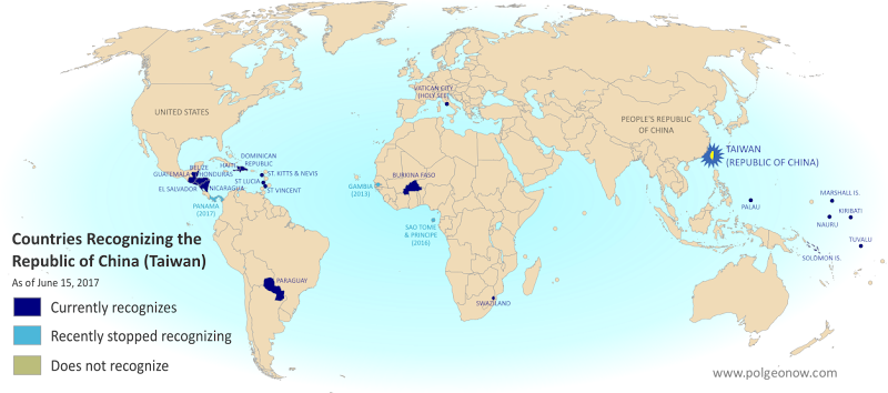
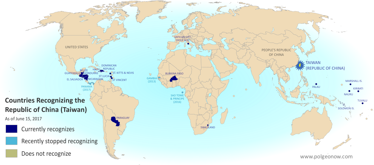
Map of who recognizes Taiwan (what countries recognize the Republic of China) in June 2017. Marks countries that have cut diplomatic ties with Taiwan (withdrawn recognition) in the last ten years: Panama, Sao Tome and Principe, and the Gambia. Also answers question: Where is Republic of China located? (Colorblind accessible)
Click to enlarge. By Evan Centanni, modified from public domain blank world map.

Article by Evan Centanni

Taiwan Loses Recognition from Panama

Flag of the Republic of China (Taiwan) Short Name (informal):  
• Taiwan (English)
• ROC (English)
• Táiwān (Chinese)
Official Name (in constitution):  
• Republic of China (English)
• Zhōnghuá Mínguó (Chinese)
Other names used officially:  
• “Republic of China (Taiwan)” (government offices)
• Chinese Taipei (international sports)
• Taiwan, Province of China (used by UN without Taiwan’s permission)   
Capital: 
Taipei (de facto)

The Central American country of Panama announced this Tuesday that it’s cutting diplomatic relations with Taiwan. Instead, it’s setting up official ties with Mainland China, endorsing the Chinese claim that Taiwan is part of China.

The island of Taiwan operates like an independent country today, but is governed under the constitution of the “Republic of China” (ROC), the government that ruled Mainland China before the communist revolution (the government that now rules the Mainland is called the People’s Republic of China).

Because the China-Taiwan dispute was originally over which side was the rightful government of China, and because the now-powerful Mainland government insists Taiwan can’t be a separate country, other countries have to choose to recognize just one or the other.

This is the first time Panama has ever recognized the People’s Republic of China, having maintained relations with the Republic of China ever since it was founded in 1912 (long before the ROC government moved to Taiwan).

Republic of China: Shrinking Recognition

Today, only 20 countries (about 10%) still have formal diplomatic relations with the Taiwan-based Republic of China government – the closest equivalent to “recognizing” Taiwan as a country. Before Panama cut ties this week, the last country to switch from Taiwan to China was São Tomé and Príncipe last December.

Only one country, the Gambia, abandoned Taiwan between 2008 and 2016, during a “diplomatic truce” initiated by Taiwan’s most Mainland-friendly president (even then, China waited until Taiwan elected a more independence-leaning president before restoring its own relations with the Gambia).

Graphic of the Republic of China (Taiwan) flag is in the public domain (source).

“Islamic State” in the Philippines? Detailed Control Map & Timeline of the Marawi Conflict

Map of so-called Islamic State (ISIS/ISIL) control in the Philippines, during the May-June 2017 crisis involving the Maute group and Abu Sayyaf takeover of Marawi Ciy, Lanao del Sur province, Mindanao. Updated to June 4, 2017, shows detailed control of Marawi by barangay. Includes map of area affected by martial law declared by President Rodrigo Duterte. Colorblind accessible.
Map by Evan Centanni. All rights reserved.

Article by Evan Centanni

(Subscribers click here to view this article in the members area.)

Rebellion in the Southern Philippines

For the past week and a half, headlines have chronicled an alleged new front in the war against the so-called “Islamic State” (IS; formerly ISIS/ISIL). A recently-formed armed organization known as the Maute group (after the family name of the two brothers who lead it) has launched a rebellion in Marawi, capital of Lanao del Sur province of the southern Philippines, apparently allying with elements of the older Abu Sayyaf organization to spread the vision of IS into southeast Asia. Marawi is a historic center for Muslim culture in the Philippines, and the largest city in the country’s partially self-governed Autonomous Region in Muslim Mindanao (ARMM).
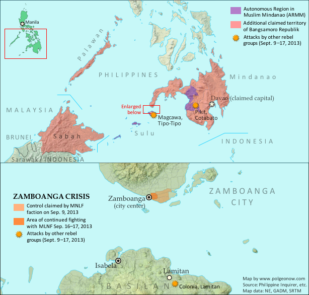
Map of territory in the Philippines and Malaysia claimed by the separatist Bangsamoro Republik, plus territorial control by the Moro National Liberation Front (MNFL) as part of the 2013 Zamboanga crisis.

The southern Philippines has a long tradition of rebellions led by members of the minority Moro ethnic group, whose main difference from the rest of Filipinos is that they’re Muslims rather than Christians. But different armed groups vary widely in their goals. Some, like the MNLF group that declared an independent “Bangsamoro Republik” in 2013, just want increased self-governance for the Moro people, without necessarily involving religion in government.

Others, like the Moro Islamic Liberation Front (MILF) – currently waiting for the Philippine government to approve a 2014 peace deal that would convert the ARMM into a more self-governed “Bangsamoro” region – are more religiously-oriented, but still support democracy.

Abu Sayyaf and the Maute group, on the other hand, are religious hardliners, who believe in the far-right ideologies of violent Salafi Muslim groups like Al Qaeda and IS. According to media in the Philippines, the Maute brothers call their organization “Dawlah Islamiyah” (Arabic for “Islamic State”), and have pledged allegiance to the leadership of the Islamic State organization in Iraq and Syria. Meanwhile, they appear to have been working closely with Isnilon Hapilon, a leader of Abu Sayyaf who IS claims as its top representative in the Philippines.

Martial Law in Mindanao

On the first day of the violence in Marawi, citing the attacks and alleged attempts at rebellion against the government of the Philippines, President Rodrigo Duterte declared martial law across the entire Mindanao island group (roughly the southern third of the country). The declaration allows for indefinite detention of suspects without trial, and will last for 60 days unless revoked or extended by the national legislature.
Flag of the PhilippinesCountry Name:  
• Philippines (English)
• Pilipinas (Filipino)
Official Name:  
• Republic of the Philippines (English)
• Republika ng Pilipinas (Filipino)
Capital: Manila

Former president Ferdinand Marcos controversially used martial law to maintain dictatorial powers across the Philippines for 8 years starting in 1972. However, the country’s current constitution, in addition to the time limits, also doesn’t allow for the courts or legislature to be overridden under martial law. This limited type of martial law declaration was also used by President Gloria Macapagal Arroyo for one week in 2009.

President Duterte himself grew up in the Mindanao region from a young age, and before his election as president served as longtime mayor of Davao, the largest city in Mindanao and second largest in the country after greater Manila. Some of Duterte’s ancestors were reportedly Muslims from the Marawi area.

Timeline of Maute Control

The following is a timeline of territorial control and other events related to the Marawi conflict. Sources are provided as in-line links. The accuracy and truthfulness of officially-available information has been called into question regarding these events, but PolGeoNow has done our best to consult a wide range of sources and provide as accurate a story as possible.

Note: The entire Philippines is divided into neighborhood/village-level administrative units known as “barangays”. Referencing these units is a useful way of tracking events on a very local scale, but because they’re very small, can change frequently, and aren’t well documented online, there’s often confusion over the exact locations and correct names of specific barangays. Because of this, references to barangays in the media and our timeline – as well as their status and locations on the above map – won’t always be 100% accurate.

November 24 – December 1, 2016
The Maute group seized control of the town of Butig, 50 km (30 mi) south of Marawi, until being driven out by the Philippine military after six days of fighting. The military estimated there were 61 Maute fighters killed in the episode and 12 injured, while 35 Philippine soldiers also sustained injuries.

May 23, 2017
Marawi City: Around 2pm at “the lower portion of the Mindanao State University Compound” in Barangay Basak Malutlut, clashes broke out between the Philippine military and fighters of the Maute group. The military had been attempting to arrest Isnilon Hapilon, a leader of the Abu Sayyaf armed group and reputed top representative of the so-called “Islamic State” (IS) in the Philippines.

By about 3pm, fighting broke out in the Caloocan neighborhood, near the Lanao del Sur provincial police command. According to early reports, during the afternoon Maute-affiliated fighters took over “Barangays Saber, Sarimanok, Mapandi, Amai Pakpak, the area near the provincial jail, [Basak] Malutlut, and Calookan [Caloocan]”. Later reports said the fighters had seized 11 barangays: Basak Malutlut, Bangon, Saber, Tuca, Bangolo, Naga, Moncado Colony, Caloocan, Marinaut, Mapandi, and Matampay.

A humanitarian organization reported that fighters raised a black flag, of the design used by the so-called “Islamic State” (IS; formerly ISIS/ISIL) and some Al Qaeda affiliates, at the Amai Pakpak Hospital. The hospital administration later denied that the facility had been taken over, while confirming it had been the site of a scuffle between Maute fighters and police.

Marawi City Jail, City Hall, the city’s main street, and two bridges were also reportedly occupied by the attackers, while St. Mary’s Cathedral was seized and its priest and 14 church workers taken hostage. Meanwhile, the city jail, a church, Ninoy Aquino School, and Dansalan College were set on fire. The fighters reportedly released 107 inmates from the city jail and neighboring Malabang District Jail. [Editor’s note: PolGeoNow was unable to confirm a map location for the Marawi City and Malabang District Jails, which appear to be different from the provincial jail.]

Residents said many of the fighters could not speak the local Maranao language, instead conversing in tongues native to the Sulu Islands, where Abu Sayyaf is known to operate. In addition, intelligence sources later estimated that up to 10 percent of pro-Maute combatants in Marawi were foreign fighters, mostly from Malaysia, Indonesia, and Singapore, but also including “at least one Pakistani, a Saudi, a Chechen, a Yemeni, an Indian, a Moroccan and one man with a Turkish passport.”

Thousands of Marawi residents fled the city to escape the violence, as ground troops in armored personnel carriers attempted to contain the Maute fighters, and airstrikes were conducted at the shore of Lake Lanao. Police reportedly closed down all entry and exit points to Iligan City, 40 km (25 mi)  to the north.

At 10pm, Philippine Presdient Rodrigo Duterte declared martial law in the Mindano island group, cutting short a visit to Russia so he could return to the Philippines.

May 24, 2017
Fighting reportedly reached a pause, as the military held its ground while awaiting reinforcements. A humanitarian spokesperson from the regional government said the conflict-affected neighborhoods were “Barangays Basak Malutlut, Caloocan, Abubakar, and Bangolo”. [Editor’s note: There does not appear to be any barangay called “Abubakar” in Marawi.]

Marawi’s police chief and another police official were killed in confrontations, while government agencies bused fleeing civilians to three new evacuation centers in Iligan City, and the Maute group threatened to behead the priest of St. Mary’s Cathedral if the military didn’t pull out of the city. The military reported that 13 Maute fighters and 5 Philippine soldiers had been killed since the beginning of the incident. The city of 200,000 was reportedly “like a ghost town” after tens of thousands of residents fled for safety, though 800 were sheltering within Marawi at the Lanao del Sur provincial capitol building.

May 25, 2017
Army tanks and assault helicopters entered Marawi, while residents said the Maute fighters looted and burned civilian homes. A military spokesperson said that Amai Pakpak Hospital, Marawi City Hall, and Mindanao State University had been cleared of Maute fighters.

The same day, fighting was reported from Barangays Malimono, Gadungan, Bangolo, and Marinaut. The military said the heaviest fighting occurred around two bridges in Barangay Bangolo, while elsewhere in the city Maute fighters attacked the Camp Ranao army base and occupied the LASURECO electric company headquarters. Airstrikes were conducted in Barangays Gadungan, Basak Malutlut, and Bangon. 

May 26, 2017
The military announced that the death toll in the Marawi conflict had increased to 31 Maute fighters and 11 Philippine soldiers, in addition to the two police officers killed on the 24th.

May 29, 2017
The government said it was “in full control of Barangays Matampay, Basak Malulut, Barrio Green, Bangon and Saduc, the peripheries of the Mindanao State University campus and the Amai Pakpak Hospital and the Matampay area.” Major fighting occurred in Marinaut and around the LASURECO compound. The military apparently prevailed at the latter location, rescuing several hostages, and also evacuated a number of civilians from Barangay Saber.

May 30, 2017
A week after the conflict began, the military said Maute group fighters were “still present” in nine barangays. Progress in retaking the rest of the city had been slowed by Maute snipers targeting soldiers from buildings under their control. Media quoted the death toll of the Marawi conflict at 20 “members of the security forces”, 61-64 Maute fighters, and 19-24 civilians, while the Red Cross estimated that 3,000 residents were still trapped in their homes. Meanwhile, the military admitted that Maute fighters had captured an armored personnel carrier – a type of tank.

A regional news report – dated June 2 but apparently referring to the situation as of May 30-31 – listed Mindanao State University, Matampay, Saber, and Basak Malutlut as “areas declared clear” by the military. Areas not yet “cleared” included “Banggolo, Raya Madaya I and II; Lilod Madaya, Dagodoban, Padian, Barrio Naga, Marinaut West and East; Caloocan, Pangarungan, and Moncado Colony”. [Editor’s note: “Pangarungan” seems to refer to the same area also known as Barangay Moncado Colony.] Barangays Banggolo, Raya Madaya I and II, and Marinaut were also reportedly inaccessible due to airstrike damage. Over 3,000 residents were estimated to still be trapped in their homes, even after the rescue of more than 2,300, who were brought to the provincial capitol.

May 31, 2017
According to eyewitness media accounts, the Mapandi and Bayabao bridges were still under Maute control after one week, with the group inferred to control much of the town center as well. Military accounts said Maute fighters controlled only 10% of the city, with 89 members of the group killed since the start of the conflict. One military source said the fighers were confined to just four barangays: Bangolo, Lilod Madaya, Raya Madaya I, and Raya Madaya II.

Hapilon and the two Maute brothers were believed to still be in Marawi. The Marawi City Jail and Malabang District jail were reported to still be under Maute control as well, with their staff trapped inside. The military’s fatality count for the conflict rose to 120 Maute fighters and 36 soldiers, including 10 killed accidentally by a government airstrike. The official count of civilian deaths remained at 19.

June 2, 2017
Ongoing military efforts were reportedly focused on Bangolo in Marawi’s downtown. Meanwhile, military forces reportedly eliminated a Maute sniper position in Mapandi, while airstrikes continued in the area. Delays in securing control of the city were attributed to Maute snipers and use of civilians as a human shields. A military spokesperson admitted that the government would not achieve its goal of gaining complete control over Marawi by June 2.

Meanwhile, IS claimed credit for an alleged attack on a casino in the Philippine capital city of Manila, which the Philippine government insisted was actually a robbery attempt by a lone gambler – an interpretation apparently supported by video of the events. The attacker fired a weapon multiple times, but reportedly didn’t shoot anyone (except eventually himself); however, 37 people died as an apparent result of fires he started.

June 3, 2017
Though military efforts were reportedly still focused on Barangay Bangolo, civilians were also said to still be trapped in the nearby Raya Madaya neighborhood. The Philippine government said it believed the fighters had prepared in advance for their takeover attempt, and may have received assistance from IS in the Middle East. Meanwhile, the military raised the official death toll to 120 Maute members, 38 government personnel, and 20 civilians, after a resident was allegedly shot by a Maute sniper while being evacuated. The government also raised its estimate of the total remaining Maute fighters to “200 to 250” in addition to the 120 already killed, after having estimated a total of just 100 the previous week.

June 4, 2017
A four-hour humanitarian ceasefire, arranged directly with one of the Maute brothers by the Moro Islamic Liberation Front (MILF) rebel group, allowed 134 non-combatants to be evacuated from the heart of the fighting in Barangay Bangolo. The MILF, Mindanao’s most powerful rebel group, which is awaiting the completion of a peace deal with the government, has opposed the Maute takeover but not directed its forces to get involved militarily.

Meanwhile, President Duterte announced he had accepted an offer by Nur Misuari, leader of the MNLF rebel faction that took over another city in Mindanao in 2013, to send 2,000 fighters to help the government against the Maute group. The president publicly invited the communist New People’s Army (NPA), the country’s oldest active rebel group, to do the same.

Related: Map of 2013 MNLF Rebel Control in the Philippines’ Zamboanga City

Also on June 4, a humanitarian agency said over 220,000 people had fled the violence, of whom about 58,000 were staying in evacuation centers and 163,000 were living at the homes of family members. Meanwhile, a news agency released photos of the destruction caused by government airstrikes in downtown Marawi.

Following this story? To check for updates, view all Philippines articles on PolGeoNow!

Graphic of the flag of the Philippines is in the public domain (source).

The Maldives’ Withdrawal from the Commonwealth

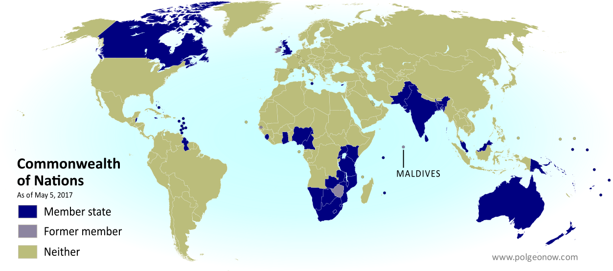
Map of current and former member countries of the Commonwealth of Nations (British Commonwealth) as of May 2017, showing where the Maldives are on the world map after the country left the organization (colorblind accessible).
Map by Evan Centanni, modified from public domain blank world map

Article by Evan Centanni

Maldives Quits the Commonwealth

Flag of the Gambia Country Short Name:  
• The Maldives (English)
Dhivehi Raajje (Maldivian)
Official Name:  
• Republic of Maldives (English)
•Dhivehi Raa’jeyge Jumhooriyya (Maldivian)
Capital: Malé

The Maldives, a country of small islands in the Indian Ocean, withdrew from the Commonwealth of Nations last October, three weeks after the organization threatened it with suspension for a third time over human rights and democracy concerns.

Formerly called the “British Commonwealth”, the Commonwealth of Nations is a loose association of countries that used to be part of the British Empire. One of its main roles is promoting democracy, human rights, and economic development, and the organization’s monitors have accused the Maldivian government of various anti-democratic activities since the country’s first elected president was deposed in 2012.

Learn More: What is the Commonwealth, and Which Countries Are In It? (Map)

A high-profile international news documentary had also accused the government of extensive corruption the month before the country withdrew. For its part, the Maldivian government accused the Commonwealth of picking on a tiny country as a way to get attention and show off its dedication to democracy. In a statement responding to the Maldives’ withdrawal, the Commonwealth’s secretary-general expressed “sadness and disappointment”, but also hope that the country would eventually choose to rejoin the organization in the future.

The Maldives isn’t the first country to quit the Commonwealth under human rights pressure. In fact, it’s the third in fifteen years, after the Gambia left for similar reasons in 2013, and Zimbabwe did the same ten years earlier.

Related: Queen Elizabeth’s 16 Countries: The Commonwealth Realms

Graphic of the Maldivian flag is in the public domain (source).

UK Votes to Quit EU: Map of How Britain Voted in the Brexit Referendum

(Subscribers click here to view this article in the members area.)

By Evan Centanni

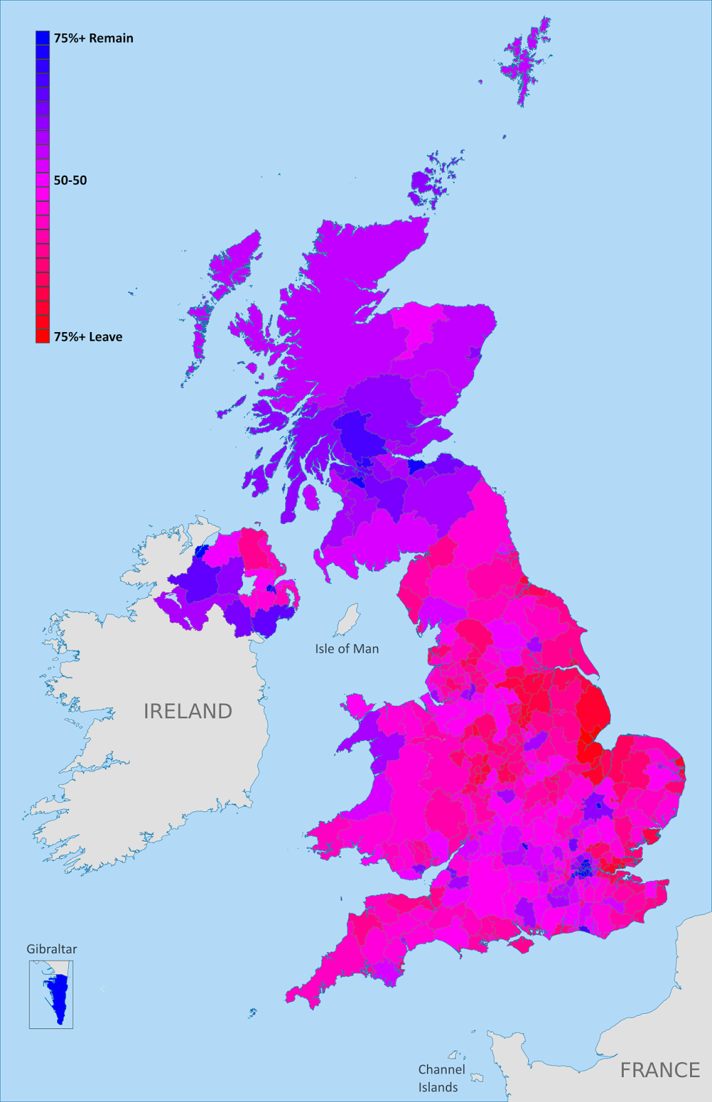
UK Brexit vote map: Map of election results in Britain's June 2016 referendum on leaving the European Union (EU). Continuous red-to-blue color scheme gives a more honest depiction of the similarities between different election districts. Colorblind accessible.
Map of election results in the UK’s “Brexit” referendum. Modified by Evan Centanni from Wikimedia map by Mirrorme22, Nilfanion, TUBS, and Sting (CC BY-SA).

UK Votes to Quit EU
The results are in for yesterday’s referendum on UK membership in the European Union, and the winner is “Leave”. Brits voted by a margin of 52% to 48% in favor of exiting the European Union, making a “Brexit” (British exit from the EU) more or less guaranteed in the coming years. Britain will become the first member country ever to leave the EU, and the British overseas territory of Gibraltar is expected to get pulled out with it.

Learn More: Brexit: 9 Geography Facts You Should Know About the Referendum and Britain’s EU Membership

Who Voted to Stay
Voter tendencies varied a lot from place to place. Support for the “Remain” side was strong across Scotland, culturally Irish parts of Northern Ireland, the London area, and a handful of other cities in England (led by Cambridge, Oxford, and Brighton).

By far the greatest show of support for Remain was a win by 96% in Gibraltar – which isn’t even in the UK proper, but got to vote because of its unique status as a British external territory that’s in the EU.

Photo Essay: Gibraltar and the Brexit Referendum

Gold: Districts with over 50% for Remain
Blue: Districts with over 50% for Leave
Map from Wikimedia Commons (click for more info)

Who Voted to Leave
The “Leave” vote, on the other hand, was strongest in eastern England, with substantial support from all across England, Wales, and the most ethnically British parts of Northern Ireland. The vast majority of the UK’s population lives in England, and this was enough to carry the referendum.

The district with the highest support for Leave was Boston, England, where 76% of voters favored leaving the EU

England, Wales, Scotland, and Northern Ireland
Taking the UK’s “constituent countries” as wholes, England and Wales each voted 53% for Leave vs. 47% for Remain, while Scotland supported Remain by 62% to 38%, and Northern Ireland supported Remain by 56% to 44%.

Scotland was the most consistently supportive of Remain, with every district at least 50% in favor of staying in the EU. England, Wales, and Northern Ireland all had some districts that went each way, though Northern Ireland was probably the most geographically divided, with 7 districts favoring Leave, and 11 favoring Remain.

Brexit: 9 Geography Facts You Should Know About the Referendum and Britain’s EU Membership

(Subscribers click here to view this article in the members area.)

By Evan Centanni 

The European Union. Click for full map and list of members.

Today the UK is voting on whether to leave the European Union. If you’ve been paying attention to the news, you’ve probably heard about the intense debate over whether Brits should vote “Leave” or “Remain”. But if you’re like me and mainly in this for the geography trivia, here are some fun facts you might not know about the so-called “Brexit”:

1. The UK has been a member of the EU since before there was an EU

The European Economic Community (EEC), founded in 1957 for economic cooperation between democracies in Western Europe, was the predecessor of today’s European Union. The UK wasn’t a founding member of the EEC, but joined in the organization’s first wave of expansion in 1973, along with Ireland and Denmark (plus the British territory of Gibraltar and the Danish territory of Greenland). This made the UK automatically a member when the EEC and related organizations were relaunched as the more ambitious European Union in 1993.

2. Long before the UK wanted to leave the EU, France didn’t want to let it in

The UK chose not to join the European Economic Community (EEC) in 1957, but changed its mind and applied for membership a few years later. But its first two attempts to join, in 1963 and 1967, were vetoed by French President Charles de Gaulle. De Gaulle thought the UK was too different from mainland Europe, and that allowing it into the organization could only slow down the other countries’ progress. Then, just like now, leaders of Britain’s three major political parties favored membership, while British “anti-European campaigners” wanted no part of it. Still, the EEC’s other five members – Belgium, the Netherlands, Luxembourg, Italy, and West Germany – favored the UK to join, and after De Gaulle lost power in 1969, France conceded the point.

3. The UK would be the first member country ever to leave the European Union

Ever since the EEC was formed in 1957, all the way through the inauguration of the EU and up to today, no member country has ever left the organization. If Britain votes today to leave, it will be the first. But there are three territories that have historically quit the EEC/EU: (1) Algeria, considered part of France until its independence in 1962; (2) Greenland, a Danish territory, which negotiated an exit in 1985; and (3) Saint Barthélemy, a French island in the Caribbean, which opted out in 2012 after splitting with fellow French territory Guadeloupe. Since these three territories were only part of the EU through connections to their parent countries, the organization never actually lost any members.

4. Until 2009, it was arguably illegal for a member country to leave the EU

Overseas territories can more or less leave the EU at will, as long as their parent countries consent. But for member countries themselves – like the UK – the original EEC and EU charters didn’t provide a clear path for exiting the organization. For decades, it was up for debate whether countries had an unwritten right to withdrawal, or whether the treaties binding member countries to the EU were legally permanent. This could have made it a long and bitter legal battle if the UK had tried to quit Europe in earlier decades. But since 2009, with a new treaty revising the basic EU rules, member countries have a guaranteed option to negotiate an exit from the organization (though that treaty was nearly vetoed by voters in Ireland).

5. Many citizens of other countries can vote in the Brexit referendum

The UK and lots of other countries that used to be part of the British Empire (plus a couple that weren’t) are now part of an organization called the Commonwealth of Nations. There about a million voting-age citizens of other Commonwealth countries (such as Australia, India, Canada, or Nigeria) living in Britain now, and British law allows them to vote there as well. But citizens of other Commonwealth countries are only allowed to vote in the referendum if they currently live in the UK.

6. Citizens of other EU countries don’t get a vote – unless they’re from Ireland, Malta, or Cyprus

Citizens of all EU countries also have the right to live in Britain, as part of EU law. But they don’t get to vote in the EU referendum, even if they live in the UK. That is, not unless they’re from Malta, Cyprus, or Ireland. Maltese and Cypriot citizens living in the UK can vote because their countries are also part of the Commonwealth (see above). Ireland left the Commonwealth in 1949, but Northern Ireland is still part of the UK, and a special treaty gives all Irish citizens the right to vote in the referendum if they live in Northern Ireland or Great Britain (British citizens can also vote in Ireland if they move there).

7. Most residents of British overseas territories can’t vote either (except Gibraltar)

The UK still has quite a few overseas territories left over from its colonial days – mostly small islands scattered across the world’s seas. Together, they have a population of about a quarter million people, most of whom are now British citizens. But just being a UK citizen isn’t enough for you to vote in the Brexit referendum – even citizens from England aren’t eligible if they’ve been outside the UK for more than 15 years (and overseas territories aren’t technically part of the UK, even though they legally belong to it). The one exception is Gibraltar, a British territory in southern Europe, whose people have been specially granted the vote as residents of the only British overseas territory that’s inside the EU.

(Photo Essay: Gibraltar and the Brexit Referendum)

The Channel Islands and the Isle of Man, whose special status as “crown dependencies” makes them more like younger siblings of the UK than territorial possessions, aren’t part of the EU, and residents only get to vote if they’ve lived in Britain in the last 15 years.

8. The referendum isn’t technically the last word on whether Britain leaves the EU

When UK citizens go to the polls today, they’re joining in a public consultation on whether their country should quit the European Union. But even if they vote “Leave”, the UK can’t actually exit until its legislature, the Parliament, separately votes to repeal the EU treaty laws. The referendum isn’t actually legally binding, so members of parliament could vote against the will of the people if they wanted. But as BBC says, that would be considered “political suicide“, and probably wouldn’t happen – unless the parliament decides to have early elections, and legislators get replaced by new members campaigning on an anti-Brexit platform. But that’s pretty unlikely too, since two-thirds of the current parliament would have to vote to put themselves up early for re-election.

9. Even if the people vote “Leave”, it will be a long time before Britain actually leaves the EU

Though EU member countries do now have the right to leave the organization, they’re expected to negotiate with the rest of the EU over the details. The 2009 Treaty of Lisbon sets a time limit of two years, after which the exiting country doesn’t have to put up with any more, and can leave whether it’s reached an agreement or not. But many observers think the negotiations would take even more than two years, with the British government agreeing to extend the deadline to avoid a bad arrangement. So even if “Leave” takes the day, the UK will likely be part of the EU for some years to come.

Stay tuned to PolGeoNow for more on the geography of the Brexit referendum!

Learn More: 
Which Countries Are in the EU, Which Aren’t, and Which Want to Join?
What’s the difference between the EU and Europe’s Schengen free travel area?
Which countries use the euro currency? (Hint: Many EU members don’t!)