Syria Civil War Map: August 2013 (#11)

There are newer versions of this map available. To see them, view all Syria updates.

Syria’s civil war has continued to rage through the summer, with small changes in territorial control and the area of fighting. Here’s the updated conflict map, plus a summary of recent territorial changes and other developments.

Map of fighting and territorial control in Syria's Civil War (Free Syrian Army rebels, Kurdish groups, Al-Nusra Front and others), updated for August 2013. Includes recent locations of conflict and territorial control changes, including Salma (Latakia), Nawa (Daraa), and Ras al-Ayn (Hasakah).
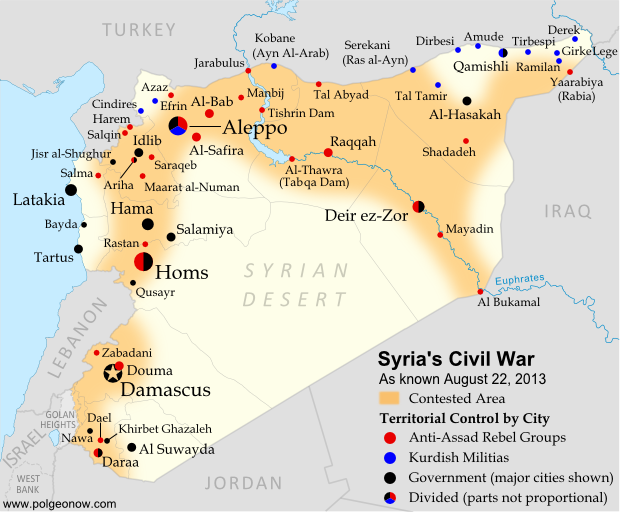
Area of fighting and territorial control in Syria’s civil war, updated for August 2013. Map by Evan Centanni, starting from this blank map by German Wikipedia user NordNordWest. License: CC BY-SA

Latest Fronts
Over the last two months since our previous Syria war map, fighting increased in three different corners of the country. In the northwest, rebels pushed farther into the coastal province of Latakia, a stronghold of President Bashar al-Assad and his native Alawite ethnic group. The rebel forces captured and briefly held several Alawite villages in the mountains before being pushed back to their base in Salma.

Meanwhile, fighting has heated up in the already contested Daraa province of southwestern Syria. Most notably, the rebels stormed the major town of Nawa in July, before losing it to the Syrian army again this month. In the country’s opposite corner, the far northeastern province of Hasakah, Kurdish militias finally seized full control of Serekani (Arabic name: Ras al-Ayn) from religious extremist rebels who had been fighting for the town since last year. Apparently in response, the extremists have pushed farther into Kurdish territory elsewhere in the province.

Flag of Syria under the current governmentCountry Name:  
• Syria (English)
• Sūriyya/Sūryā (Arabic)
Official Name:  
• Syrian Arab Republic (English)
• al-Jumhūriyyah al-‘Arabīyah  as-Sūriyyah (Arabic)
Capital: Damascus

Fighting in Major Cities
Syria’s three largest cities have remained battlefields over the past months, with number-one metropolis Aleppo still bitterly divided between the government, the rebels, and Kurdish groups. The Syrian army has made further inroads into Homs, and now controls most but not all of the key central city.

While central Damascus remains mostly out of reach for the rebels, fierce battles have continued to be waged over the capital city’s many suburbs (see a map of rebel and government control in the city from two weeks ago).

Broad Trends
An expert quoted in a New York Times article last month estimated that Syria’s rebel groups now control 60-70% of the country’s land, but only 40% of the population, due to their greater success at controlling rural areas than holding major cities.

Meanwhile, the opposition remains as disorganized as ever, having proved unable to form a national-level interim government for the rebel-held areas. But the starkest sign of disunity between the various anti-Assad groups has been the breakout of major fighting between the secular-minded Free Syrian Army (FSA) rebels and the religious extremists of the Nusra Front and the ISIS (“Islamic State of Iraq and Syria”). The latter groups have emerged as the strongest rebel force in many areas of Syria, driving the FSA out of Raqqah city as part of their rise in power across the country’s north and east.

Small Adjustments
This edition of the map returns to showing Ariha, a major town in Syria’s northwestern province of Idlib whose status had been unclear for many months. Recent reports indicate that it is divided between rebel and government control. In central Syria, the war has now reached the previously peaceful city of Salamiya, which was shelled by rebel forces two weeks ago.

Similar Articles:
Syria Civil War Map: June 2013 (#10)
Mali Conflict Map: National Territory Reunited
War in Somalia: Map of Al Shabaab Control

Graphic of the Syrian flag is in the public domain (source).

Map: Kosovo Recognized by 4 More Countries (101/193)

Map of countries that recognize the Republic of Kosovo as an independent state, updated for August 2013 with most recent additions and disputed recognitions highlighted
Countries recognizing the Republic of Kosovo in green, with the four most recent additions highlighted. Disputed recognitions in yellow. Kosovo in magenta. Map by Evan Centanni, modified from public domain graphic (source).

Flag of the Republic of KosovoCountry Name:  
• Kosovo (English, Serbian)
• Kosova (Albanian)
Official Name:  
Republic of Kosovo (English)
Republika e Kosovës (Albanian)
Republika Kosovo (Serbian)
Capital: Pristina/Prishtina

By Evan Centanni

New Kosovo Recognitions
Over the past four months, the breakaway Republic of Kosovo has received diplomatic recognition from two more U.N. member countries. The self-proclaimed southeastern European country now claims recognition from 101 U.N. member countries (52%), up from 99 in our previous Kosovo recognition update (see “Disputed Recognitions” below for details on why the total has only been incremented by two).

Tanzania, a republic in East Africa, recognized Kosovo at the end of May, and nearby Egypt extended its recognition a month later (just days before the breakout of its current constitutional crisis). Yemen had already endorsed Kosovo’s independence earlier in June, and the small Central American country of El Salvador apparently followed suit by the end of the month.

The Republic of Kosovo declared independence from Serbia in 2008, but has been blocked from U.N. membership by objections from Serbia, Russia, and other countries who see its secession as invalid. In addition to the 101 U.N. members from whom Kosovo claims recognition, its independence is also acknowledged by non-U.N. member Taiwan. For more on Kosovo’s special situation, see our first Kosovo recognition report, which also includes a map of Kosovo’s location relative to Serbia.

Disputed Recognitions
As explained in our previous Kosovo recognition report, there has been doubt cast on some of Kosovo’s claimed recognitions. In fact, if the Kosovan government’s past disputed claims of recognition are included, the total number of U.N. member countries recognizing the breakaway state is now 103. However, a recent report from Kosovo’s foreign ministry only claims 101 U.N. member recognitions, even while acknowledging the four most recent additions. This suggests they may finally have given up on the questionable claims of recognition from  Nigeria and Uganda (the third disputed recognition, from São Tomé and Príncipe, is better documented). In any case, the total number of countries recognizing Kosovo now forms over half of the U.N. membership even without counting disputed recognitions.

Stay Up to Date: Check for further updates to this story by viewing all Kosovo articles on Political Geography Now.

Related Articles:
North Kosovo Status Changing After Serbia Deal
Kosovo Recognition Update: April 2013
Who Recognizes Palestine in 2013?
 

Flag graphic by Cradel (source). License: CC BY-SA

Japan-China Dispute: The Eight Islands of the Senkaku/Diaoyu Group (Aerial Photos)

Map of the Senkaku/Diaoyu Islands, disputed between Japan, China, and Taiwan; includes location as well as detail of islands
Map of the disputed Senkaku/Diaoyu Islands (by Evan Centanni). Click to view at full size.

Article by Evan Centanni

The Senkaku/Diaoyu Islands
A recent feature on Political Geography Now introduced the history and status of the Senkaku/Diaoyu Islands, a disputed territory controlled by Japan but claimed by China and Taiwan. The article included an original map which showed the isles’ configuration and precise location within the East China Sea (click on the map at right to see it at full size). But if you’re like me, you may be wondering “just how small are these islands, and what do they really look like?”

Luckily for you and me, aerial photographs of many places in Japan have been released by the Japanese government and uploaded with English labels to Wikimedia Commons. Included in the collection are shots of each of the disputed isles, known as the Senkaku Islands to the Japanese, the Diaoyu Islands to the Chinese, and the Diaoyutai Isands to the Taiwanese. Here are the photos and a brief profile of each island:

Aerial photo of Uotsuri-shima (魚釣島)/Diàoyúdǎo (钓鱼岛)/Diàoyútái (釣魚臺), the largest of the Senkaku/Diaoyu islands disputed between Japan, China, and Taiwan

Japanese: Uotsuri-shima (魚釣島)
Chinese (China): Diàoyúdǎo (钓鱼岛)
Chinese (Taiwan): Diàoyútái (釣魚臺)
Area: 4.32 km2 (1.67 mi2)
Highest Point: 383 m (1,257 ft.)
The largest isle in the disputed archipelago, Uotsori has been a center of historical activity in the Senkaku/Diaoyu Islands. It was the site of a Japanese fish-processing plant from about 1900-1940, when it hosted 200 workers. Since then it has been uninhabited, but was visited by a Japanese academic-governmental delegation for four weeks in 1979.

The island was one of four sold to the Kurihara family in the 1970s. The Japanese government rented the island from 2002, before finally buying it from the family last year. Though the island is no longer inhabited by humans, it is home to a population of domestic goats and albatross, as well as a species of mole found nowhere else on earth. Once called “Peaks Island” by the British, the current name means “Fishing Island” in both Japanese and Chinese (the name used by Taiwan is literally “Fishing Platform”). (photo source)

Aerial photo of Kita-kojima (北小島)/Běi Xiǎodǎo (北小島/北小岛) and Minami-kojima (南小島)/Nán Xiǎodǎo (南小島/南小岛), two major parts of the Senkaku/Diaoyu Islands disputed between Japan, China, and Taiwan

Japanese: Kita-kojima (北小島)
Chinese: Běi Xiǎodǎo (北小島/北小岛)
Area: 0.33 km2 (0.13 mi2)
Highest Point: 135 m (443 ft.)

Japanese: Minami-kojima (南小島)
Chinese: Nán Xiǎodǎo (南小島/南小岛)
Area: 0.46 km2 (0.18 mi2)
Highest Point: 149 m (489 ft.)
These are the only other major islands in the main cluster of the Senkakus. Like Uotsuri, they were sold to the Kurihara family in the 1970s, rented by the Japanese government from 2002, and bought by the government in 2012. The islands’ names are written the same in both Japanese and Chinese, and mean “Northern Little Island” and “Southern Little Island” respectively. (photo source

Aerial photo of Oki-no-Kita-iwa (沖の北岩)/Běiyǔ (北屿)/Chōng Běiyán (沖北岩)/Dà Běi Xiǎodǎo (大北小島)/Běiyán (北岩), group of rocks which form part of the Senkaku/Diaoyu Islands disputed between Japan, China, and Taiwan

Japanese: Oki-no-Kita-iwa (沖の北岩)
Chinese (China): Běiyǔ (北屿)
Chinese (Taiwan): Chōng Běiyán (沖北岩)
Other Chinese Names: Dà Běi Xiǎodǎo (大北小島), Běiyán (北岩)
Area: 0.02 km2 (0.01 mi2)
Highest Point: 28 m (92 ft.)
This is actually a small group of islets located in the northeast of the Senkaku Islands’ main cluster. It consists mainly of barren rocks, and has apparently never been privately owned. The Japanese and various Chinese names are variations on “Northern Islet” or “Northern Rock”; yet one name, Dà Běi Xiǎodǎo, means “Big Northern Little Island”, seeming ironically to imply that it outsizes the much larger Běi Xiǎodǎo (Kita-kojima). (photo source

Aerial photo of Oki-no-Minami-iwa (沖の南岩)/Nányǔ (南屿)/Chōng Nányán (沖南岩)/Dà Nán Xiǎodǎo (大南小島)/Nányán (南岩), group of rocks which form part of the Senkaku/Diaoyu Islands disputed between Japan, China, and Taiwan

Japanese: Oki-no-Minami-iwa (沖の南岩)
Chinese (China): Nányǔ (南屿)
Chinese (Taiwan): Chōng Nányán (沖南岩)
Other Chinese Names: Nán Běi Xiǎodǎo (大南小島), Nányán (南岩)
Area: 0.005 km2 (0.002 mi2)
Highest Point: 13 m (43 ft.)
Located at the eastern edge of the main cluster of the Senkaku Islands, this another barren rock which has apparently never been privately owned. Its names in Japanese and Chinese present it as the southern counterpart to Oki-no-Kita-iwa. (photo source)

Aerial photo of Tobise (飛瀬)/Fēiyǔ (飞屿)/Fēilài (飛瀨)/Fēiyán (飛岩)/Fēijiāoyán (飛礁岩), a reef which forms part of the Senkaku/Diaoyu Islands disputed between Japan, China, and Taiwan

Japanese: Tobise (飛瀬)
Chinese (China): Fēiyǔ (飞屿)
Chinese (Taiwan): Fēilài (飛瀨)
Other Chinese Names: Fēiyán (飛岩), Fēijiāoyán (飛礁岩)
Area: 0.0008 km2 (0.0003 mi2)
Highest Point: 2 m (7 ft.)
Tobise is a cluster of rocks located just southeast of Uotsuri, the biggest island of the Senkakus. Although the area of shallow water surrounding it gives it a larger profile on some maps, according to the Taiwan government’s measurements it is the smallest of the eight major named isles of the Senkaku/Diaoyu Islands. It is also the lowest, protruding little farther above the water than the height of a person. Its Japanese and Chinese names all translate to something like “flying shoals” or “flying reef”. (photo source)

Aerial photo of Kuba-shima (久場島)/Huángwěiyǔ (黃尾嶼/黄尾屿), one of the Senkaku/Diaoyu Islands disputed between Japan, China, and Taiwan

Japanese: Kuba-shima (久場島)
Chinese: Huángwěiyǔ (黃尾嶼/黄尾屿)
Area: 1.08 km2 (0.42 mi2)
Highest Point: 117 m (384 ft.) Kuba is the second largest of the Senkaku Islands, located to the north of the main cluster. In the 1970s, it was sold to the Kurihara family along with the three major islands of the main group, but was owned by the sister of the man who the other three belonged to. Today it is still owned by the family, but rented by Japan’s Ministry of Defense. The Japanese in turn allow the U.S. military to use it as a practice bombing range for aircraft. “Kuba” is a Japanese surname, and the Chinese name means “Yellow-tail Islet”. (photo source)

Aerial photo of Taishō-to (大正島)/Chìwěiyǔ (赤尾嶼/赤尾屿), one of the Senkaku/Diaoyu Islands disputed between Japan, China, and Taiwan

Japanese: Taishō-to (大正島)
Chinese: Chìwěiyǔ (赤尾嶼/赤尾屿)
Area: 0.06 km2 (0.02 mi2)
Highest Point: 75 m (246 ft.)
Taisho is the most distant of the Senkaku/Diaoyu Islands, located over 100 km (60 mi) to the east of the main group. A relatively high island for its size, it has been continuously owned by the Japanese government since Japan formally took possession of the islands in 1895. In Japanese, the island is probably named after Emperor Taishō, the Emperor of Japan at the time when the Senkakus were annexed and developed. The Chinese name means “Red-tail Islet”. (photo source)

(Photos from Wikimedia Commons, based on National Land Image Information (Color Aerial Photographs), Ministry of Land, Infrastructure, Transport and Tourism of Japan. Used under terms of copyright.)

Related Articles:

Niger and Burkina Faso Resolve Territorial Dispute