2016 Year in Review: Country & Border Changes

Inside this Review of 2016:
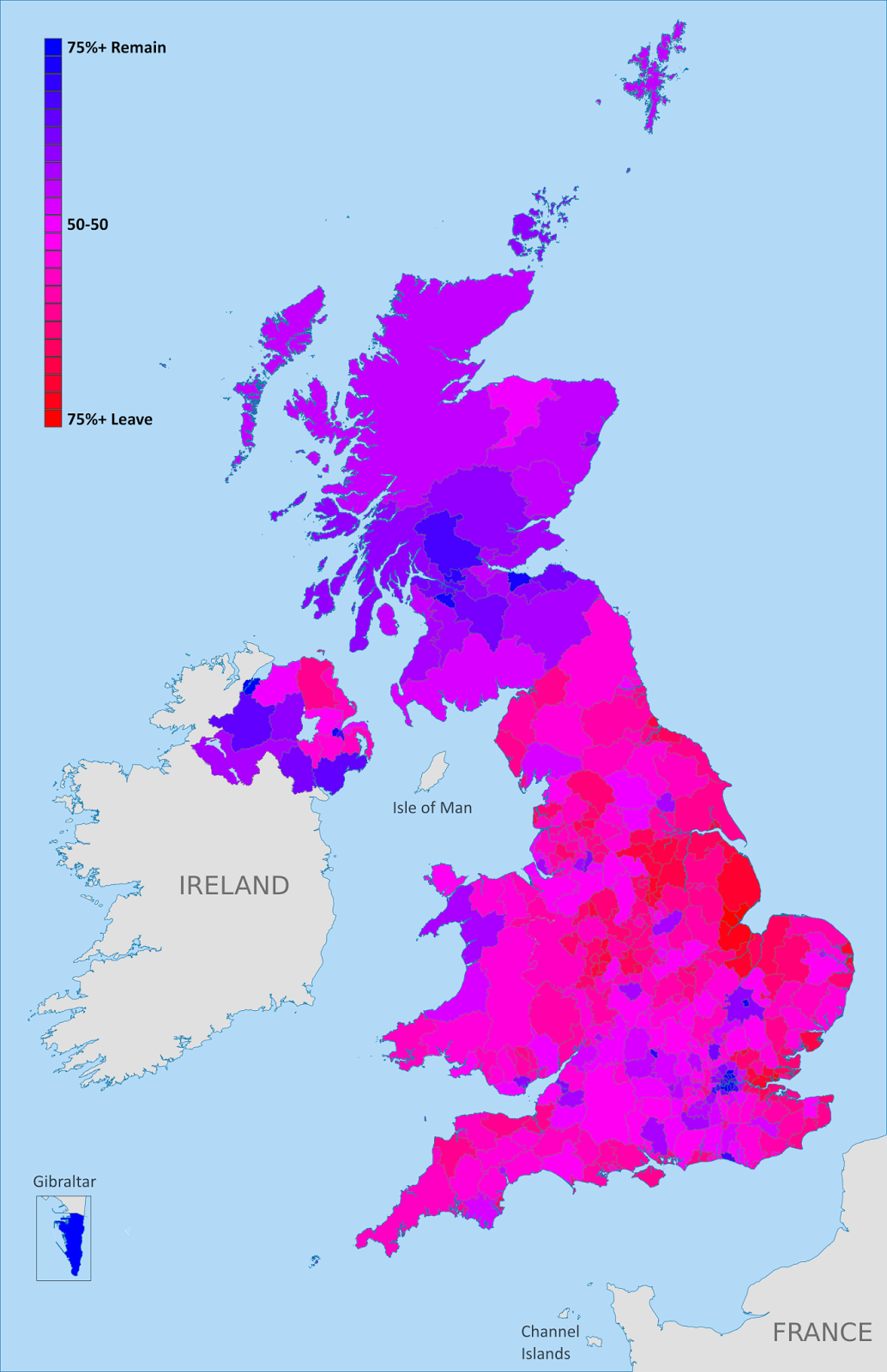
Map of election results from the UK’s “Brexit” referendum on leaving the European Union
    • Country name, capital, and flag changes
    • Border changes and disputed territories 
    • Separatist states and proposed new countries
    • Recognition of disputed countries 
    • Countries joining (and leaving) international organizations
    • Sea borders and seabed claims
    • New states and provinces within countries
    • Changes to countries’ coastal contours and official languages

        And in companion articles:
        Rebel Control Around the World in 2016 
        Time Zones that Changed in 2016 

        It’s PolGeoNow’s mission to track changes to the world’s countries, borders, and territories, whether it’s happening formally on the books or unofficially on the ground. When new countries appear, borders change, and territorial disputes arise or are settled, you’ll hear about it here. With 2016 now concluded, here’s our look back at the events of the year!

        (For extra coverage of geography events in 2017, follow @PolGeoNow on Twitter!)

        Country Name Changes

        In 2016, the Gambia registered an official name change with the UN, switching its full formal name from “Republic of the Gambia” to “Islamic Republic of the Gambia”. This confirmed the possible name change that we had reported on in our review of 2015

        The Czech Republic is now officially “Czechia” for short
        (Map by David Liuzzo (CC BY-SA))

        The other big country name news last year came from the Czech Republic, which registered “Czechia” as its official short name, keeping “Czech Republic” for formal circumstances.

        Also in the news in 2016 was the US government’s quiet change of policy regarding the name of Myanmar, also known as Burma. “Burma” was the official name of the country until it was changed to “Myanmar” in 1989, and the US had continued using the old name as a protest against the undemocratic government that initiated the name change. However, this fall the US administration appeared to be ending that policy after using the name “Myanmar” in an official press release.

        See all PolGeoNow articles on country name changes

        Flag and Capital Changes

        As far as PolGeoNow has been able to determine, no country changed its flag or capital city in 2016. But that doesn’t mean there wasn’t any news at all…

        New Zealand’s people voted against making this their new flag

        Fiji, which had announced a plan to remove the British “Union Jack” design from its flag in 2015, finally abandoned the plan in August 2016 after months of delays. Meanwhile, New Zealand held the second round of its flag change referendum vote, but citizens chose to keep the old flag rather than change to a new design chosen in a 2015 vote from a government shortlist of candidates.

        In the US state of Mississippi, a political dispute over the state flag – which includes the battle emblem of the 19th Century separatist Confederate States of America, seen by many as a symbol of slavery – continued into 2017.

        See all flag change articles on PolGeoNow

        Border Changes

        Though no borders officially changed in 2016, Belgium and the Netherlands did agree on an adjustment to their border, which will go into effect after it’s ratified by their legislatures. Meanwhile, consulting firm Stratfor reported that the practical border between Georgia and breakaway South Ossetia is continuing to creep slowly southward, increasing the size of the unrecognized country (there’s no officially agreed-upon border between the two countries, since neither Georgia nor most of the world recognizes South Ossetia’s independence).

        Remote Norfolk Island was integrated into Australia in 2016
        (Map by TUBS/Wikimedia CommonsCC BY-SA)

        Another change to practical border arrangements happened between Australia and its external territory of Norfolk Island, which in 2016 was designated as “domestic” for travel purposes. Australia’s external territories are technically considered part of the country already, but have varying degrees of integration with the Australian mainland.

        And while the Netherlands and Belgium were finalizing their border agreement, another proposed adjustment in Europe died. A popular campaign for Norway to gift a mountaintop to Finland as a 100th birthday present eventually succeeded at being considered by the Norwegian government, but was ultimately rejected.

        See all articles on border changes

        Tiran and Sanafir Islands remain disputed between Egypt and Saudi Arabia, despite the Egyptian government’s efforts to give them up.

        Disputed Territories

        PolGeoNow didn’t discover any territorial disputes that were fully resolved in 2016, but one nearly was. In April, the Egyptian government signed a border treaty with Saudi Arabia, controversially giving the disputed islands of Tiran and Sanafir, previously controlled by Egypt, to the Saudis. Saudi Arabia quickly ratified the treaty, leaving the ball in the Egyptian parliament’s court. But before the parliament could vote, the deal was blocked by an Egyptian court, and the future of the agreement is still uncertain.

        Meanwhile, a sort of change territorial control happened at the disputed Scarborough Shoal in the South China Sea, claimed by both China and the Philippines. Chinese ships had been blockading the mostly-underwater reef since 2012, but after a warming of relations between the two countries, they began allowing Philippine ships to fish there again. But China hasn’t given up on its ownership of Scarborough Shoal, and reportedly still interferes occasionally with Philippine fishing operations.

        And though tensions with the Philippines were running lower by the end of 2016, China was still causing controversy in the South China Sea, as it began to place weapons on the artificial islands it’s built in the Spratlys, while also clinching its control of the Paracel Islands through the construction of both civilian and military infrastructure. Meanwhile Vietnam, which claims both the Paracels and the Spratlys, began matching China’s moves with construction and militarization of its own.

        Map of the border between Sudan and South Sudan, marking selected territorial disputes and border clashes in 2012. Includes inset map of April fighting in region of Heglig oil field.
        Sudan and South Sudan’s many border disputes became a little less hopeless in the last year

        Elsewhere in the world’s disputed territories, the the Japan-controlled Senkaku/Diaoyu Islands continued to be hotly contested by China, while heavy fighting broke out on the disputed Ethiopia-Eritrea border, and at the line of control between India and Pakistan in disputed Kashmir. On the other hand, the once hotly-disputed border of Sudan and South Sudan began to cool down, as demilitarization plans materialized and both countries said they were ready to work on peacefully settling their border disputes.

        Other disputed territories in diplomatic focus last year were the Hala’ib Triangle, where Sudan decided to take its dispute with Egypt to the UN Security Council; Gibraltar, which Spain pressured to switch allegiances after the UK’s Brexit vote; the Esequibo, which Guyana was preparing to defend anew from longstanding Venezuelan claims; and the Kuril Islands, which claimants Russia and Japan resumed discussions over.

        For disputes over territorial seas and other waters, see the “Sea Borders and Claims” section below.

        See all articles on disputed territories

        Declarations of Independence: New Countries in 2016?

        Just as in 2015, last year didn’t see any declarations of independence from serious breakaway states or credible aspiring countries. Uganda’s government claimed in late November that rebels operating near the border with the Democratic Republic of the Congo were operating a “parallel government” in the name of an independent “Yiira Republic” – but local officials played down the claim, saying the new country was neither a new idea nor a serious proposal.

        Meanwhile, a rebel threat to declare a “Niger Delta Republic” in southern Nigeria this August was canceled at the last minute, even as the Nigerian government allegedly killed and tortured protesters calling for the return of Biafra, a real breakaway state that existed from 1967-1970. Harder to verify were claims from Libyan officials that leaders of the Saharan Tebu people had launched a quiet diplomatic campaign for an independent country near Libya’s borders with Egypt, Sudan, and Chad.
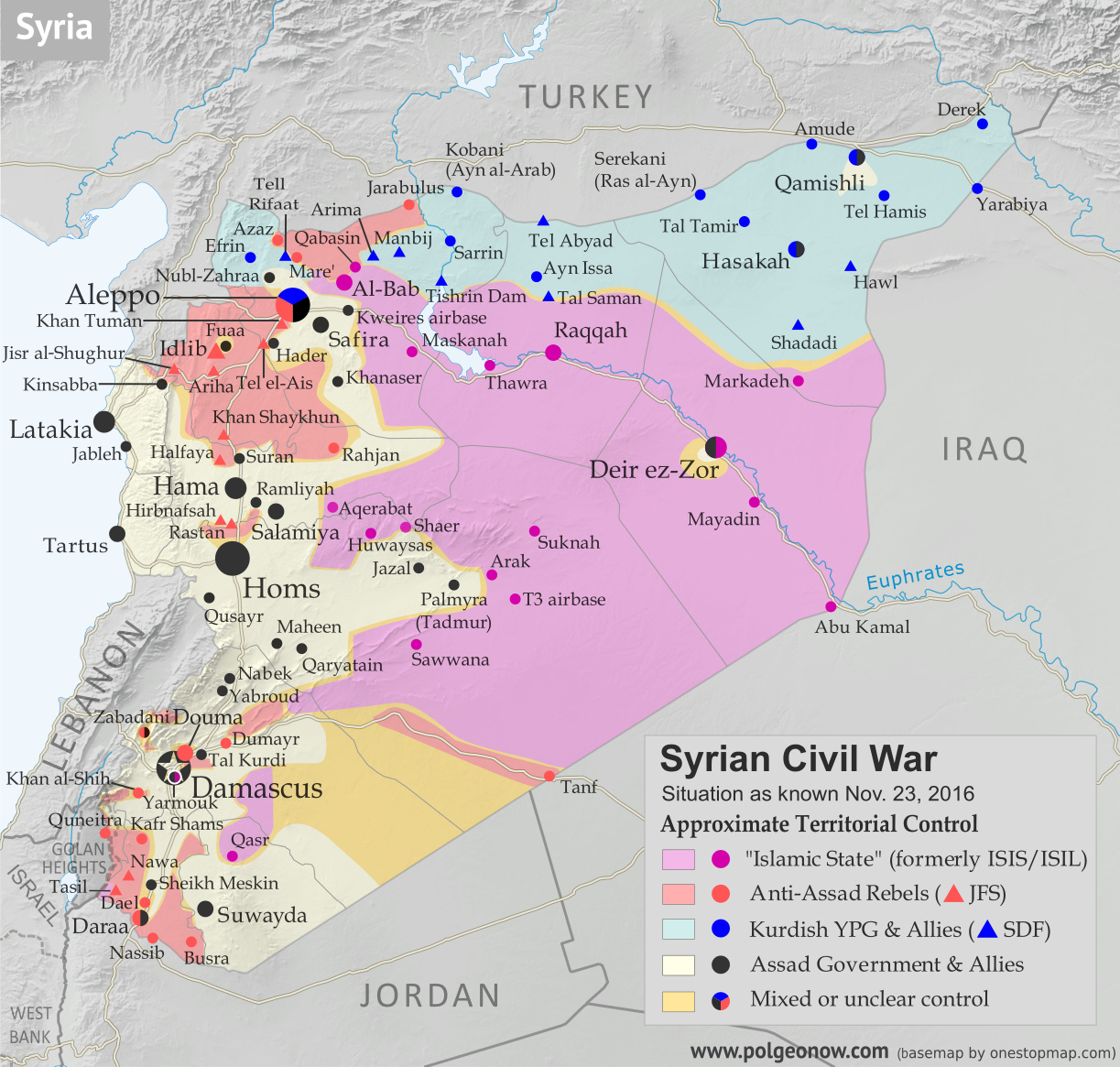
        Map of fighting and territorial control in Syria's Civil War (Free Syrian Army rebels, Kurdish YPG, Syrian Democratic Forces (SDF), Jabhat Fateh al-Sham (Al-Nusra Front), Islamic State (ISIS/ISIL), and others), updated to November 23, 2016. Now includes terrain and major roads (highways). Includes recent locations of conflict and territorial control changes, such as Al-Bab, Khan al-Shih, Tal Saman, Qabasin, and more. Colorblind accessible.

        On the other hand, the Kurdish-controlled area of northern Syria, which calls itself “Rojava”, began behaving more like an independent country in 2016, declaring a federal system of government without the approval of other parties in Syria’s civil war, and established “embassies” in Russia and the breakaway Donetsk People’s Republic of Ukraine.

        But two long-established breakaway states were looking at a possible end to their independence, with progress in negotiations to unify disputed Northern Cyprus with the Republic of Cyprus to its south, plus a plan announced by unrecognized South Ossetia to solidify its separation from Georgia by voting to join Russia.

        Popular but unlikely to succeed was a demand for the city of London to declare independence from the UK (#Londependence) so it could stay in the European Union after the Brexit vote, a proposal the city’s new mayor acknowledged but stopped short of fully endorsing. Scotland, on the other hand, was taken very seriously when its government said the Brexit could prompt it to have another vote on independence from the UK (Scotland voted in 2014 to stay in the UK).

        In Cameroon, some protesters reportedly demanded independence for a majority English-speaking part of the country (most of the country speaks French), while in the US, a small political party claimed that 40% of Californians supported their state declaring independence (and this even before Trump’s election as president). All the while, 2015’s celebrity micronation, the prospective libertarian utopia of Liberland, struggled to stay relevant as its “government” was blocked from entering its claimed territory, even while facing down a serious internal scandal.

        But the real dreamer of the year was Russian businessman, scientist, and UNESCO official Dr. Igor Ashurbeiyli, who announced the creation of a new pacifist country in outer space. The would-be nation, called “Asgardia”, is apparently a serious proposal, but seems unlikely to succeed at its bid to eventually join the UN, since international law seems to forbid countries from claiming territory in outer space.

        See all previous and future articles on newly declared countries

        Rebel Control of Territory

        Tracking territorial control in conflict zones is the mission of PolGeoNow’s conflict map subscription service, and many of our rebel control maps also appear in free articles here. In fact, tracking rebel control is such a big part of our work that we decided to publish a whole article just about territorial changes in 2016! Check it out here:

        Rebel Control Around the World in 2016

        Recognition of Disputed Countries

        Diplomatic recognition of disputed, partially-recognized countries continued to be slow in 2016. Despite France bluffing on a promise to recognize Palestinian independence if peace talks fell through, the State of Palestine failed to gain any new recognitions for the first time in a decade – perhaps signaling a return to the stagnant period from 1995 to 2004, when only one country declared its recognition of Palestinian independence.
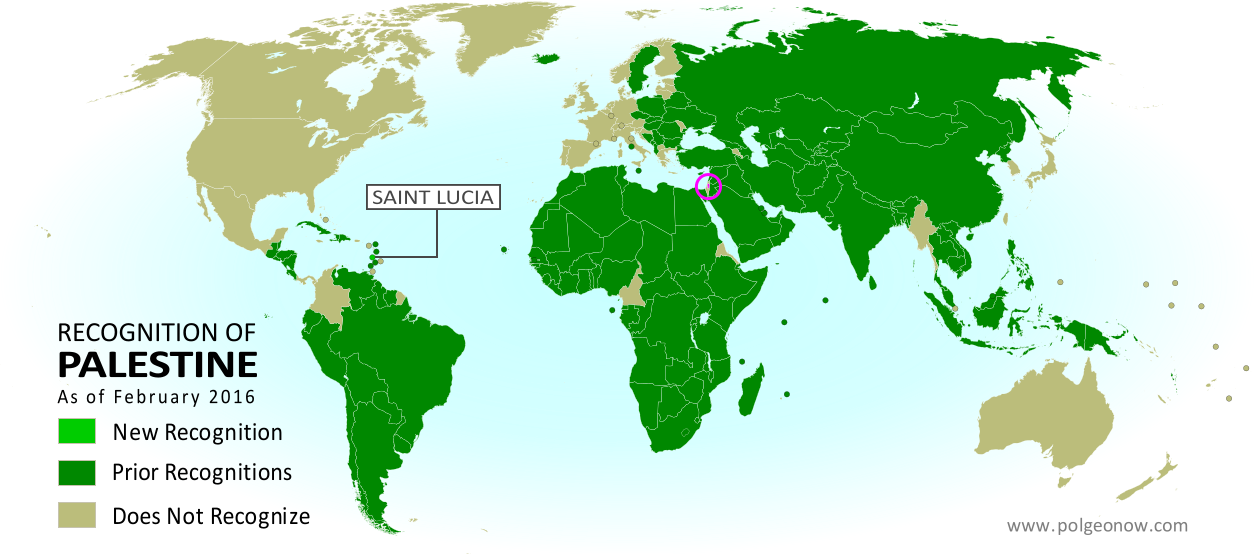
        Map of countries that recognize the State of Palestine as an independent country, updated for February 2016 with recent addition Saint Lucia highlighted
        Recognition of Palestine, as it stood in 2016

        Kosovo did a little better, winning recognition from two UN member countries: Suriname and Singapore. In 2015, one UN member country and two non-members recognized Kosovan independence, so by the numbers, 2016 was either slightly better or slightly worse for Kosovo, depending on how you count. On the other hand, Singapore is probably the most powerful country to declare its recognition of Kosovo since at least 2013. And what’s more, both the Union of European Football Associations (UEFA) and the International Federation of Association Football (FIFA) granted Kosovo membership in 2016, qualifying it to play in European soccer matches or even compete in future World Cups.

        The Sahrawi Arab Democratic Republic (SADR), the claimed independent government of Western Sahara, saw a small uptick in official support, with Panama reinstating diplomatic relations with the disputed country after suspending them in 2013. This is the second year in a row that the only change to the SADR’s recognition has been a reinstatement from a single country.
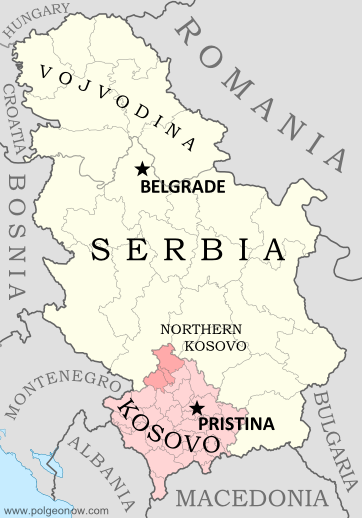
        Map of Serbia, Kosovo, and North Kosovo
        Kosovo joined FIFA in 2016

        Meanwhile UN member country Israel, which is still missing recognition from about 30 of the world’s countries, saw a renewal of diplomatic relations with Guinea, which broke relations in 1967 and was recently considered one of the countries that didn’t recognize Israeli independence. Turkey, though it already recognized Israel, upgraded its diplomatic relations with the country in 2016, after downgrading them 2011.

        Also in 2016, São Tomé and Príncipe announced it would no longer recognize the “Republic of China” government that controls disputed Taiwan, reducing the number of countries with official ties to Taiwan to just 21. Soon afterwards, São Tomé established full diplomatic ties with the People’s Republic of China (PRC), the UN-recognized government that controls Mainland China. The Gambia also established diplomatic relations with the PRC in 2016, after dropping relations with Taiwan the year before. The PRC is still missing recognition from the 21 countries that recognize Taiwan’s government instead.

        The British territory of Gibraltar also managed to win membership in FIFA in 2016, even though the organization normally doesn’t allow dependencies to join anymore.

        See all articles about diplomatic recognition
        See all articles about unrecognized or partially-recognized countries

        Intergovernmental Organizations
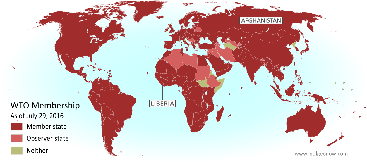
        Map of World Trade Organization (WTO) member and observer countries, updated for August 2016 to include new members Liberia and Afghanistan (labeled). Color blind accessible.
        The World Trade Organization got two new members in 2016

        The year 2016, like every year, brought many changes to countries’ membership in intergovernmental organizations:

        The biggest news about membership in international organizations was, of course, the UK’s “Brexit” vote to leave the European Union (EU), but the country is still part of the EU until it completes the withdrawal process (probably in 2018 or so). Elsewhere, Burundi, South Africa, and the Gambia announced they were withdrawing from the International Criminal Court (ICC), but because they have already ratified the treaty – unlike Russia – the law says they remain members for one more year.

        Meanwhile, Paraguay ratified Bolivia’s membership in Mercosur, leaving only Brazil to sign on before the country can join, and Morocco applied to join the African Union (AU) in a bid that would succeed in early 2017. The disputed country of Taiwan, on the other hand, was refused entry into INTERPOL, and Cuba announced it wouldn’t try to join the Organization of American States (OAS) after the group threatened to kick out Cuban ally Venezuela. And in the gray areas between countries, Syria’s powerful Jabhat al-Nusra (Nusra Front) rebel group withdrew from international terror network Al Qaeda, changing its name to Jabhat Fateh al-Sham and promising to focus on toppling the Syrian government.
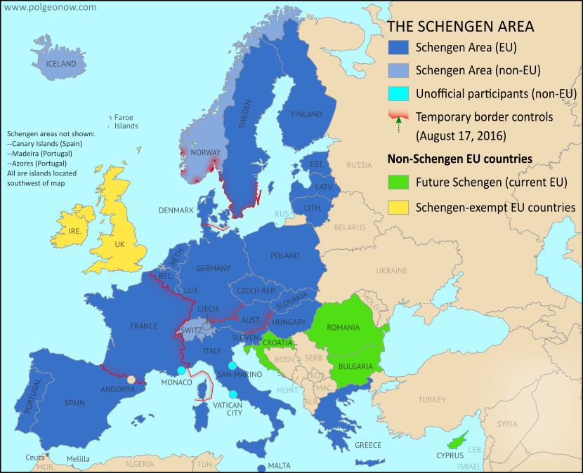
        Map of Temporarily Reintroduced Border Control in the Schengen Area (the European Union's border-free travel zone) in August 2016, color-coded for EU Schengen countries, non-EU Schengen countries, future Schengen countries, and Schengen-exempt EU countries, as well as microstates unofficially participating in the Schengen agreements (colorblind accessible).
        Reintroduced border controls in Europe’s free-travel Schengen Area

        Besides the Brexit, another political storm that dominated Europe were the cracks appearing in the continent’s free-travel Schengen Area, as member countries rushed to limit the entry of millions of Syrian and other refugees. Though threats to kick Greece out of the program never materialized, several countries did introduce “temporary” controls along borders that can normally be crossed freely. An agreement was reached in the summer to reduce the miles of border eligible for controls, but the remaining checks were still in place at the end of the year.

          See all intergovernmental organization articles

          Sea Borders and Claims

          Jurisdiction over much of the world’s ocean is still unresolved, with neighboring countries often disagreeing on where the lines fall between their respective waters, which include both territorial seas (a thin strip along the coast) and exclusive economic zones (EEZ; a much wider band where they have economic control but not full sovereignty).

          International treaty defines how much of the sea countries can claim for their own.
          (author and license information)

          The biggest maritime boundary news of 2016 was a ruling by the Permanent Court of Arbitration in the Hague, favoring the Philippines in several maritime disputes with China. China refused to participate in the case, and denounced the results as invalid, but the court’s ruling was widely considered legitimate by international law scholars, and is likely to set some legal precedents even if China never complies. The case involved the Spratly Islands and Scarborough Shoal in the South China Sea (called the “West Philippine Sea” by patriotic Filipinos), parts of which are claimed by the Philippines, China, Taiwan, Vietnam, and Malaysia.

          The court declined to rule on control of the islands themselves, saying the small pieces of land and their 12-mile territorial waters would remain disputed for now. What it did decide was that none of the Spratlys counted as a proper habitable island, meaning they don’t get their own 200-mile EEZs, and any water outside their 12-mile territorial seas but within 200 miles of other Philippine territory is the EEZ of the Philippines. It also ruled that China has no claim to any EEZ in the South China Sea beyond 200 miles from the Chinese mainland (despite the country’s “nine-dash line” claim), and that some of the Spratly reefs don’t count as land at all and are therefore part of the the Philippine EEZ.

          The decision that the islands are too small to generate EEZs could make an impact around the world, since it’s the first time a court has ruled on just how habitable an island has to be to qualify. The definition the court settled on was more strict than some had expected, excluding even islands with permanent land-based military facilities, like Taiwan-controlled Itu Aba. This precedent means many EEZs around the world could be ruled invalid in the future because the islands they’re measured from aren’t habitable enough to count.

          Elsewhere in the South China Sea, an apparently new territorial dispute popped up. China, still insisting on its unconventional “nine-dash line” claim to most of the sea’s waters and islands, announced that it had “overlapping claims” with Indonesia near the Natuna Islands. What it meant was that the nine-dash line cuts off a chunk of what would otherwise be Indonesia’s undisputed EEZ surrounding the islands.

          Map of the State of Palestine in the West Bank and Gaza Strip, including both its claimed borders (the Green Line) and zones of actual control (Area A, Area B, and Area C from the Oslo Accords)
          The Gaza Strip’s territorial waters controlled by Israel and not well defined.

          Meanwhile, in the world’s partially-recognized countries… The disputed Sahrawi Arab Democratic Republic (SADR), which claims to be the government of an independent Western Sahara (and controls a small part of it), reportedly submitted a detailed EEZ claim to the UN, including boundaries with neighboring countries. However, its claim won’t take effect anytime soon, since its entire claimed coastline is controlled by Morocco, and the UN doesn’t consider Western Sahara an independent country in the first place. Reports also spread of a coming agreement between Egypt and Palestine on their sea border, but the Egyptian government denied it. Palestine’s potential territorial sea and EEZ are currently controlled by Israel, but their boundaries aren’t well defined.

          International law also allows countries to claim rights to resources on the “continental shelf” (nearby seabed) well beyond the 200 nautical mile limit of their EEZs, but their claims have to first be registered with and approved by the UN. No new submissions came in during 2016, but the UN did approve submissions registered by Iceland, Argentina, Uruguay, and the Cook Islands (a nearly-independent country associated with New Zealand). Apparently there’s a seven-year backlog in the approval process, since all these submissions were registered in 2009.

          The approval of Argentina’s submission caused a bit of a stir, with some news headlines and Argentine officials incorrectly claiming that it endorsed Argentina’s claims over the waters of the disputed Falkland/Malvinas Islands. In fact, the UN carefully avoided ruling on those parts of the claim, only approving Argentine continental shelf rights in areas out of range of the islands. Argentina soon afterwards submitted revisions for parts of its claim, but the details haven’t been made public yet.

          See all articles on maritime borders and jurisdiction

          Provinces and States

          Though creating a new US state is a major legislative ordeal, many countries’ provinces or other divisions are created, redrawn, or abolished at will. The many changes to the world’s administrative subdivisions can be hard to keep track of, but luckily we have help from resources like the Statoids website and the ISO 3166-2 standard.

          France’s regions before 2016
          (Rosss/Wikimedia Commons CC BY-SA)

          The year 2016, for its part, kicked off with a major reorganization of France’s top-level divisions, called “regions”. As part of long-planned reforms, on January 1, 2016 France’s 22 regions were merged and consolidated into just 13. Later in the year, several of the newly-merged regions changed their names.

          Meanwhile, Mali announced that it was creating two new province-like “regions” in its northern desert, splitting off northern Timbuktu Region into Taoudenni Region, and eastern Gao Region into Menaka Region. Unlike the main cities of Timbuktu and Gao, Tuareg people form the majority in these newly-created regions, and it’s possible the reforms are intended to calm Tuareg-led groups that have long called for independence or increased self-governance in the “Azawad” area.

          France’s regions after 2016 reform
          (Chessrat/English Wikipedia CC BY-SA)

          Also in 2016, Equatorial Guinea reportedly created a new province in preparation for moving its capital to the newly-built city of Djibloho, while Mexico changed the name of its capital district from “Mexico, Distrito Federal” (DF) to just “Ciudad de Mexico” (CDMX). “Ciudad de Mexico”, or Mexico City, was already the name of the city located inside the district. The name change is part of a plan to gradually give the district more self-governance, as if it were one of Mexico’s states.

          Last year also saw the inclusion of Australian external territory Norfolk Island’s forced integration into Australia’s mainland system of governance. Many news outlets, including PolGeoNow, mistakenly reported that the territory was being merged into the state of New South Wales (NSW). In fact, the reforms put the NSW state government in charge of managing government services on the tiny island, but didn’t make it officially part of the state. In another sign of Norfolk remaining technically outside of NSW, islanders will vote in federal elections as residents of the Australian Capital Territory.

          Though neither is part of its country’s main system of subdivisions, 2016 brought an expansion to some US Indian reservations and reductions in power to Uganda’s traditional kingdoms. Tajikistan’s Gorno-Badakhshan special region also saw a decrease in self-governance, while legislators in the Philippines rejected the creation of a self-governing Bangsamoro region in the country’s Muslim-majority south, even as the president proposed turning the whole country into a federation of self-governed states like the US.

          Bangladesh created the new Mymensingh Division in 2015 (Map by NordNordWest, CC BY-SA)

          A 2015 effort by South Sudan’s president to split up the country’s 10 states into 28 remained in limbo last year, as the government and rebels struggled to find consensus on a national peace deal. India’s Assam state created two new districts before changing its mind and withdrawing their district status, but also announced the creation of a new Majuli district on a 400 sq km river island. Meanwhile, the Indian state of Manipur controversially split most of its districts in half, increasing the total number from 9 to 16.

          There were also some major changes from 2015 that only came to our attention in the past year: Bangladesh created the new province-level Mymensingh Division, tiny Luxembourg abolished one of its top-level districts, Costa Rica changed the name of one of its counties, and India’s states created several new lower-level districts (Kra Daadi and Siang in Arunachal Pradesh, and Biswanath Chariali, Hojai, West Karbi Anglong, Charaideu and South Salmara-Mankachar in Assam).

          Belarus minted its first regular-use coins in 2009, but didn’t release them until 2016.

          Currency Changes

          Unlike the previous year, no currencies died or were born in 2016. But Belarus did change the value of its money, introducing the first ever Belarussian ruble coins (other than special collectors’ coins), and both India and Venezuela ran into trouble when they rushed to replace existing paper money with newer bills.

          Part of Venezuela’s change was introducing a new 20,000 Bolivar bill, after runaway inflation reduced the value of the previous biggest note, the 100 Bolivar, to just two US cents.

          Updated map of the time zones of the world by TimeZonesBoy (click for full map and license information)

          Time Zones

          Last year saw a lot of changes to the world’s time zones – enough to fill an article of their own. So we did just that, and put together our first-ever Time Zone Changes article, with cool before-and-after maps! Check it out:

          Interactive Maps: Which Places Switched Time Zones in 2016?

          More Changes: Coastlines & Official Languages

          The shape and territory of a country aren’t affected only by where its borders are drawn, but also by the course of its coastline. And while you generally expect the beach to stay in the same place from weekend to weekend, coastlines actually are changing all the time. There are surely more small coastline changes in world than we could ever hope to keep track of, but here are a few that made the news in 2016:

          The growth of Monaco since 1861. Part of the green “Le Portier” zone is now being “reclaimed” from the sea.
          (Map by Ventic, CC BY-SA)

          In September the tiny country of Monaco approved a project to expand its land area by constructing a new neighborhood of luxury apartments, parks, and seaside facilities by filling in a small piece of the Mediterranean Sea. The new development is only six hectares (15 acres) in size, but then Monaco’s entire land area is just 2.02 square kilometers (0.78 square miles) – meaning the expansion will increase the country’s size by three percent!

          China has also been hard at work taking land from the sea, most controversially by filling in remote coral reefs to create livable islands in the disputed South China Sea – with rival claimant Vietnam following suit (see also “Disputed Territorities” and “Sea Borders and Claims” above). But China’s also been steadily expanding its coastlines on the mainland to build industrial facilities. This is probably just the biggest of many such projects going on around the world, but it’s still no Monaco: Even by upper estimates, the land reclaimed by China in recent decades only equals about one tenth of one percent of the huge country’s total land area.

          On the other end of the spectrum, Solomon Islands has reportedly been losing land area, with at least five tiny islands already lost to rising sea levels in recent years, and at least one inhabited island cut in half by related erosion.

          Technically, these coastline changes may not effect their countries’ total territorial size, since the surrounding seas were already in their territorial waters. International law is pretty clear that territorial waters don’t expand outwards when you build artificial islands and fill in coastal waters. However, it’s not completely clear whether sea territory shrinks with the disappearance of the islands or shores it’s measured from.

          Areas where Amazigh and related languages are dominant.
          (Map by P. Andries, CC BY-SA)

          Another thing that we tend to think of as a defining feature of a country is its official language or languages, and at least one country made a change to its language policy in 2016. Algeria, an Arab-majority country whose sole official tongue was Arabic until this past year (despite French being widely used in business and education), added Amazigh, or Berber, as a second official language. Berbers are the pre-Arab inhabitants of northwestern Africa, and form something a kind of indigenous group within countries like Algeria and Morocco.

          What major political geography events will happen in 2017?

          Stay tuned to PolGeoNow for lots more geography news and maps! Also, don’t forget to follow us on Twitter for extra reporting on world events, and add us on Facebook or Tumblr to get updates when new articles are published!

          Learn about more of last year’s geography changes!
          Rebel Control Around the World in 2016 
          Time Zones that Changed in 2016 
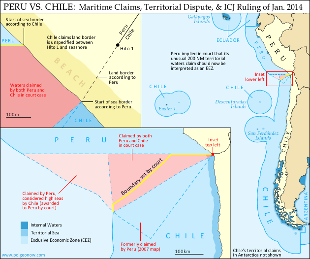
            Map: Peru & Chile’s Sea Dispute Settled in Court

            Two weeks ago, the International Court of Justice released a long-awaited ruling on Peru and Chile’s disputed maritime boundary. Many headlines claimed that Peru “won” the case, but in fact it was not a full victory for either country. Below is our detailed map of Peru and Chile’s seas and of the dispute, followed by an easy-to-understand summary of the case. 

            Map of Chile and Peru's territorial waters and exclusive economic zones (EEZ), plus the details of their territorial dispute at sea and disagreement of the land border. Shows the results of the Jan. 27, 2014 ruling by the International Court of Justice (ICJ) settling the dispute.
            Map by Evan Centanni (country coastlines and land borders from Natural Earth)

            Premium members click here to view this article in the ad-free members area. Not a member yet? Subscribe now!

            Article by Evan Centanni


            Disputed Territory
            Chile and Peru have just settled a decades-long dispute over the location of their maritime boundary (the border between their sea zones). A large wedge of sea off the countries’ coast was claimed by both sides, in part because of its high value for the fishing industry. In 2008, Peru took Chile to court over the dispute. Their disagreements would be resolved by the International Court of Justice (ICJ), a United Nations body in the Hague founded for the purpose of settling differences between U.N. member countries.

            Peruvian and Chilean Waters
            The international Law of the Sea entitles every coastal state to extend its territory out to 12 nautical miles (NM) from the shore, making these “territorial waters” fully part of the country but requiring that foreign ship traffic be allowed to pass through. The law also allows the country to regulate economic activity out to a distance of 200 NM, within what is called an “exclusive economic zone” (EEZ). Lakes, rivers, and bays (as well as coastal areas hemmed in by islands) are known as “internal waters,” where the country has absolute authority just like on its land territory.

            Flag of PeruCountry Name:  
            • Peru (English)
            • Perú (Spanish)
            • Piruw (Quechua, Aymara)
            Official Name:  
            • Republic of Peru (English)
            • República del Perú (Spanish)
            Piruw Ripuwlika (Quechua)
            Piruw Suyu (Aymara)
            Capital: Lima

            As a country with an unusually long coastline and possession of several offshore islands, Chile has a long strip of territorial waters and a huge EEZ. But Peru is a bit of a special case: it never ratified the U.N. Convention on the Law of the Sea (UNCLOS), and instead of an EEZ proper, it claims something called a “maritime domain” out to a distance of 200 NM.

            Because the Peruvian constitution claims “sovereignty” over this domain, it has always been interpreted as equivalent to other countries’ 12 NM territorial waters. However, during the court case against Chile, Peru’s government declared that its declaration of the maritime domain “is applied in a manner consistent with the maritime zones” in the UNCLOS.* This implies that Peru’s “maritime domain” is now to be considered equivalent to an EEZ rather than to territorial waters, thus curtailing any potential accusations of clearly excessive territorial claims by Peru.

            *Source: ICJ judgement, p.61

            The Dispute
            Since the dispute began some decades ago, Chile claimed that the boundary between the two countries extended due west from the end of the land border. To Chile this meant that it could it extend its own EEZ out to 200 NM directly west from its northernmost coast, but also that the line would keep going from there, cutting off any part of Peru’s maritime domain that might wrap around the outside of Chile’s (the Chilean government noted that Chile itself had made a similar concession on its sea border with Argentina). This is not one of the recommended ways of drawing a boundary under the UNCLOS, but that would all be moot if, as Chile claimed, the two countries had already agreed to it by treaty.

            Peru felt differently. It argued that the treaties cited by Chile never explicitly specified a border, and that it therefore was still entitled to negotiate one from scratch. Because Peru’s coast is oriented at an angle to Chile’s, drawing a straight line west would give Chile quite a bit of sea that was actually closer to Peru. So in an official government map from 2007, Peru instead showed the boundary running southwest at an angle of more than 50 degrees from Chile’s line.

            In court however, Peru made a more modest claim, choosing an “equidistant line” as recommended in the UNCLOS. This meant carefully calculating a path for which every point would be exactly the same distance from the closest parts of the respective Peruvian and Chilean coasts. The result was a not-quite-straight line running southwest at an angle of about 30 degrees from Chile’s border claim. The area between these two lines would become the officially defined disputed zone. Another large area west of this chunk was within 200 NM of Peru’s coast, but beyond 200 NM from Chile. This zone was claimed by Peru but considered by Chile to be neutral “high seas” (a.k.a. international waters).

            But where do the lines start?
            In fact, Chile and Peru were not even able to agree on exactly where the maritime boundary should start. The land border between the two countries had been agreed upon in the 1929 Treaty of Lima, and precisely marked on the ground with actual physical pillars. However, the last of the pillars was not right on the shore. Known as Hito 1 (Spanish for “Marker 1”), it was placed on dry land a bit inward from the beach, to ensure that it wouldn’t be washed away.

            Peru argued that the border continued, in principle, in a slight curve southwest from Hito 1, following the same circular arc that was used to place the last several border pillars. The treaty apparently wasn’t drafted with this extreme degree of accuracy in mind, and was worded in a way that suggested Hito 1 and the shoreline were the same thing. Chile used this to argue that the sea boundary should be measured along a line drawn from the pillar itself (but not starting until the line reached the seashore), and not from a point to the southwest as Peru claimed. This was taken by many to mean that Chile claimed a land border continuing west from the pillar, but in court Chile’s lawyers argued that there simply was no legally defined land boundary beyond Hito 1.

            Flag of ChileCountry Name:  
            • Chile (English, Spanish)
            Official Name:  
            • Republic of Chile (English)
            • República de Chile (Spanish)
            Capital: Santiago

            The Judgement
            After years of waiting and over a year of deliberation, the court finally released its ruling on January 27, 2014. Media headlines declared the judgement a “win” for Peru, but in fact it was a complex compromise arrived at through a step-by-step examination of each country’s claims.

            The Starting Point and Land Border
            The court first needed to decide where the maritime boundary should start. Although Peru argued that it was impossible for a land border to just end without reaching the coastline, the court found that before the dispute began, the two countries had consistently used Hito 1 to define where their respective waters met. This was a small win for Chile, meaning that the maritime boundaary must indeed be drawn from the marker itself rather than from the end of an arc as claimed by Peru.

            However, defining the land border itself was not on the court’s agenda, so the disagreement over its course technically remains standing. The court noted that the land border does not necessarily have to end at the same place the sea border begins, meaning that Peru’s claimed land border extension could still be valid even now that it’s irrelevant to the course of the sea boundary.

            The Course of the Sea Border
            To examine the history of Peru and Chile’s claims, the court examined a series of declarations and treaties published by the two countries in the 1940s and 1950s. It found that both countries had indeed declared jurisdiction out to 200 NM, but that they initially didn’t have any particular border in mind. Instead, their early declarations were intended to protect their waters from foreign whaling and other exploitation, not from each other.

            With each treaty they increasingly implied that there was a border running straight west from the coast, but never seemed to say it explicitly. It seemed that perhaps an informal agreement had been made and never put on paper. However, the last treaty referred clearly enough to a straight-west boundary that the court decided it was a done deal. The maritime boundary between Chile and Peru would be line running straight west from Hito 1 – a win for Chile.

            But wait – it wasn’t as simple as that. Although the court agreed that Chile and Peru had fixed their straight-west border by treaty, it argued that they had never intended for it to run all the way out to 200 NM or beyond. The agreements referring to the border were only concerned with defining where local fishing boats were allowed to cast their nets, and back then these small boats wouldn’t have ventured out past about 80 NM. The court’s decision, then, was that the boundary should run straight west only to a point 80 NM from the shore – beyond that, there was no line legally agreed upon by treaty.

            Beyond 80 NM, the court ruled that Peru indeed had the right to a boundary calculated from an equidistant line out to the farthest point within 200 NM of both countries’ coasts. But since this line started from the end of the 80 NM straight-west line, it ended up quite a bit farther north from Peru’s claimed boundary, giving Chile nearly half of the disputed zone. However, it was still seen as a substantial victory for Peru, since Chile had been seen as controlling the entire zone up until then.

            The court also ruled that Peru was indeed entitled to any area of sea within 200 NM of its own coast but beyond 200 NM from Chile. This means that the area previously considered high seas by Chile will indeed become part of Peru’s maritime domain, and even after drawing the equidistant line, a bit of this zone still wraps around the outside of Chile’s EEZ, adding one more segment to the maritime boundary between the two countries.

            Dispute Resolved
            Though the course of the land border may remain a small sticking point, the sea dispute between Peru and Chile has now been settled (that is, unless the countries argue over the exact coordinates of the line, which were not explicitly named by the court). The ICJ’s ruling is binding, and both Chile and Peru have agreed to respect the court’s decision. Peru’s president Ollanta Humala said he was “pleased” with the ruling, and that he would act quickly to ensure its implementation. President Michelle Bachelet of Chile, on the other hand, called it a “painfull loss,” even while promising to “gradually” implement it.

            Full Text: ICJ Judgement of 27 January 2014 – Maritime Dispute (Peru v. Chile)

            Related: Map of the Falkland Islands’ Disputed Seas (Argentina vs. U.K.)

            Graphics of the Peruvian flag (source) and the Chilean flag (source) are in the public domain.

            Lies Your World Map Told You: 5 Ways You’re Being Misled

            Unfortunately, most world political maps aren’t telling you the whole story. The idea that Earth’s land is cleanly divvied up into nation-states – one country for each of the world’s peoples – is more an imaginative ideal than a reality. Read on to learn about five ways your map is lying to you about borders, territories, and even the roster of the world’s countries.

            Map of the world's countries according to the U.S. Central Intelligence Agency
            The lines and coloring on this map are hiding major truths about the world’s countries.
            (Source: U.S. CIA; public domain)

            1) Missing Countries
            When choosing what counts as a country, most world maps go by either the official list from their own country or the member/observer roster from the United Nations. Just one problem: there are about ten countries which have declared and enforced their independence, but aren’t recognized by the U.N. or most of the world’s governments. These states may have close ties to a neighbor country, but most of them aren’t at all controlled by the country they’re supposed to be part of.

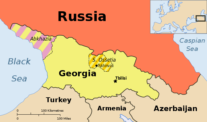
            Map showing Abkhazia and South Ossetia, two breakaway states claimed by Georgia.
            Abkhazia and South Ossetia operate as independent countries, but are claimed by Georgia and only recognized by a few countries. Map by Ssolbergj (CC BY-SA).

            There are some high-profile special cases that warrant at least a note on many maps. Taiwan’s government formally claims to represent non-communist China, though it acts more like a separate country. Palestine, another disputed state, is now recognized as a U.N. observer country despite being forced to share control of its territory with Israel.

            Western Sahara‘s status is considered unresolved by the U.N., and a small piece is effectively independent; meanwhile, Northern Cyprus is recognized only by its patron country, Turkey. The self-proclaimed Republic of Kosovo is now recognized by half of the U.N.’s members but not by the U.N. itself.

            Other countries escape entirely from all but the most careful of political maps, being misleadingly merged into the countries that claim their territories: Abkhazia and South Ossetia into Georgia, Nagorno-Karabakh into Azerbaijan, and Transnistria into Moldova. These four breakaway states are sponsored by neighboring countries, but the most left out of all is Somaliland, which receives no major support or recognition from anyone, despite managing its affairs completely independently from Somalia.

            Unrecognized Countries: More Articles and Maps

            2) Incomplete Control
            Drawing lines around a country on the map might imply that its government controls all the land within those lines. But that’s often not the case in reality. Even setting aside foreign military occupations like the recent U.S. interventions in Iraq and Afghanistan, many countries’ governments don’t control their whole territories. Aside from the cases of breakaway states as described earlier, this mainly occurs in war zones where rebel groups are actively vying for control of all or part of the country.

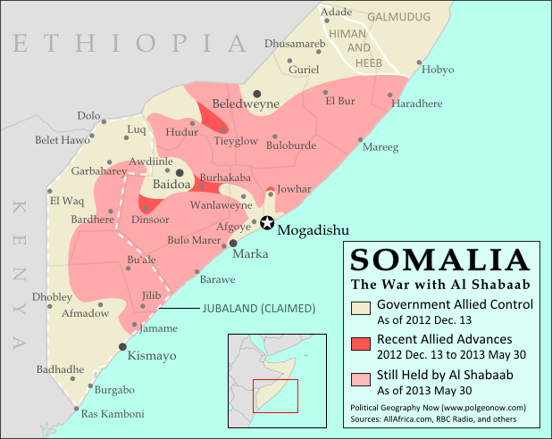
            Map of government and Al Shabaab control in Somalia's ongoing civil war
            Large parts of Somalia are controlled by Al Shabaab extremists. Click for map attribution info (CC BY-SA).

            Somalia is probably the most infamous for this. Its U.N.-recognized government controls around half the country at best, and a few years ago controlled nothing but a part of the capital city! The rest is divided between the religious extremist Al Shabaab and various autonomous states which keep their own counsel on whether to cooperate with the government.

            The territories of Mali, Nigeria, the Central African Republic, Libya, and Ivory Coast have all only recently been reunited (either under the former government or under the rebels), and Syria is the current model of a state falling apart through violence. Other countries with rebels firmly controlling parts of their territory are Yemen, the Democratic Republic of the Congo, and Myanmar/Burma.

            Divided Countries: More Articles and Maps

            3) Undefined Borders

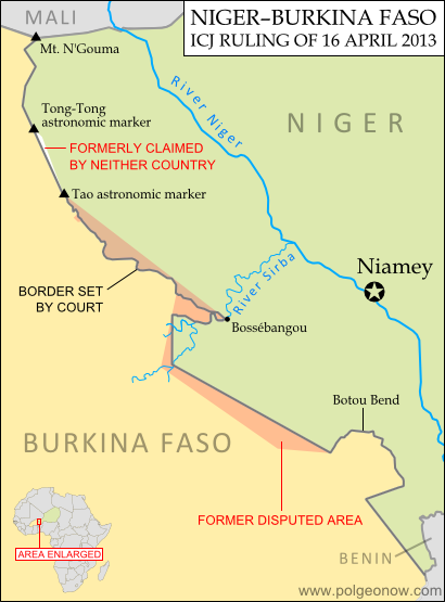
            Map of the border dispute recently resolved between Niger and Burkina Faso
            Niger and Burkina Faso recently resolved an unclear border situation. Map by Evan Centanni (click for details; CC BY-SA).

            Another thing political maps imply is that borders at least have strictly defined locations in principle, even if they’re usually invisible on the ground. If they weren’t well-defined, they wouldn’t all be drawn with solid lines on the map, right? Wrong. Many countries have borders that have never been precisely defined by treaties, a process called “delimitation”.

            Even fewer have been actually “demarcated”, or marked on the ground. In fact, undefined borders are such a big issue among the relatively young countries of Africa that the African Union operates an official border program to encourage the ongoing delimitation of national boundaries.

            The fudge factor in national borders isn’t always big enough to make a difference to where they’re drawn on the world map – but their fuzziness can sometimes have major effects on international relations. An undefined border is a ripe environment for the birth of territorial disputes when neighboring countries have different ideas of where the border should run.

            Sometimes these disputes are only low-level disagreements, such as the one recently resolved between Niger and Burkina Faso; but in other places like the border between Sudan and South Sudan, they can escalate into bloody conflicts.

            Undefined Borders: More Articles and Maps

            4) Disputed Territories
            Your world map may label a few well-known territorial disputes, caused either by vague borders or conflicts over island groups. You might then reasonably conclude that disagreements over who owns a place, though they do happen, are relatively few and far between. Unfortunately, your conclusion would be incorrect. There are far more disputed territories in the world than you’ve probably ever imagined.

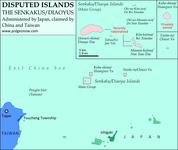
            Map of the Senkaku/Diaoyu Islands, controlled by Japan but claimed by China and Taiwan
            Map of the Senkaku/Diaoyu Islands, disputed between Japan, China, and Taiwan (map by Evan Centanni).

            The most bizarre disputes range from high-profile cases, such as the five-way feud over the Spratly Islands, to quieter anomalies like Bir Tawil between Sudan and Egypt, both of whom claim it belongs to the other.

            You may have heard of those, but did you know that (at least on paper) Mongolia is claimed by Taiwan? Or that more than half of Guyana is claimed by Venezuela? What about the several territories disputed between the U.S. and Canada? And those are just the land disputes – wait until you hear about the oceans!

            Disputed Territories: More Articles and Maps

            5) Territorial Seas
            One thing completely left off of most maps is ownership of the sea. The occasional border lines you see across straits on your map are just showing who owns the islands on either side, not who owns the sea in between. The uninterrupted expanse of blue on most maps then might imply that the seas are the domain of no country. This is true for parts of the open ocean far from any coastline – but closer in, countries can and do exercise territorial rights over their neighboring seas. According to international best practices, a country is entitled to extend its territory up to 12 nautical miles (NM) out from its coastline, regulate economic activity out to 200 NM, and sometimes control seafloor oil and mineral exploration out to much further.

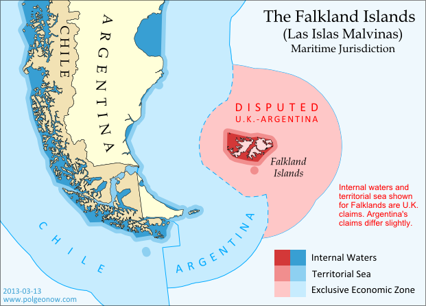
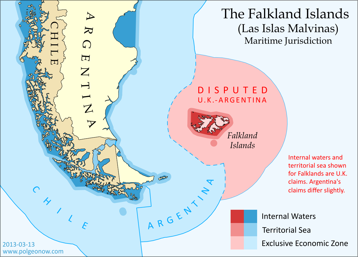
            Map of territorial seas and exclusive economic zones (EEZ) around the Falkland Islands (Malvinas), controlled by the U.K. but claimed by Argentina
            Both the land and the seas of the Falkland Islands are disputed between the U.K. and Argentina. Map by Evan Centanni (click for details; CC BY-SA).

            But the divvying up of the world’s seas is still an ongoing process, and there are probably even more maritime disputes than land-based ones. Some countries, like Peru and Ecuador, refuse to recognize the 12 NM limit, claiming sovereign territory out to a full 200 NM. In even more cases, neighboring countries just can’t agree on where to draw the border between their respective territorial seas.

            International law does provide guidance on how to divide it up, but for now many countries make claims far beyond what seems reasonable, apparently hoping they have something extra to give away in future negotiations. The most extreme claims, like China’s infamous “Nine-dotted Line” around most of the South China Sea, don’t seem to follow much legal logic at all.

            Maritime Jurisdiction: More Articles and Maps

            So next time you find yourself looking at a political map of the world, remember to be critical and take those borders with a grain of salt!

            Other Articles You Might Like:
            5 Countries You’ve Never Heard Of (by Their Native Names) 
            How Many Countries Are There in the World?
            Parade of Nations: Which Countries Are (and Aren’t) in the Olympics?
             

            What is North Korea?

            North Korea’s threats of war have captured the world’s attention in recent weeks, leaving citizens of other East Asian countries anxiously awaiting the latest news. A new war is unlikely, but how much do you know about North Korea, its international status, and its dispute with the south?

            Map of North Korea and South Korea
            Map by Johannes Barre & Patrick Mannion (CC BY-SA) (source)

            What is North Korea?
            Located on the northern half of the Korean Peninsula between South Korea and China (and sharing a short border with Russia), North Korea is a medium-sized East Asian country of about 24 million people. Despite its size, it boasts the fourth-largest army in the world, and has remained officially at war with South Korea since 1950.

            Sometimes considered one of the world’s last remaining communist states, North Korea actually claims no longer to follow communist ideology. However, it surely does hold the distinction of having the world’s most closed borders, with its totalitarian government tightly controlling the flow of information and people in and out of the country.

            What territory does North Korea claim?
            North Korea doesn’t actually have “north” in its official name, which is the Democratic People’s Republic of Korea (DPRK). This is because it claims to be the rightful government of all of Korea, including the south. South Korea (officially the Republic of Korea) also maintains the same claim, with both sides seeking eventual unification. Korea hasn’t been a single independent country for over 100 years, since it lost its independence in 1905 and was absorbed into the Japanese Empire in 1910.

            How did Korea become divided?

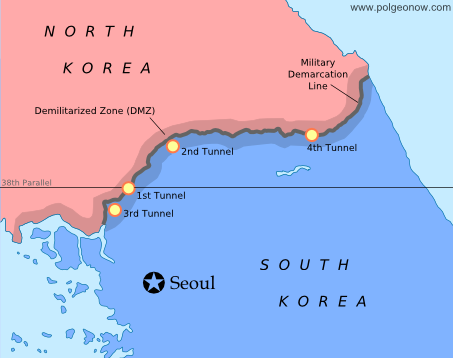
            Map of the Military Delimitation Line (armistice line) and Demilitarized Zone (DMZ) separating North and South Korea
            Armistice line and DMZ dividing North and South Korea. Modified by Evan Centanni from this map by Rishabh Tatiraju (CC BY-SA).

            When Japan lost World War II in 1945, Korea was divided temporarily between U.S. and Russian control, with the boundary placed arbitrarily at the latitude 38° north. However, the Russian-held area in the north and the U.S.-held area in the south ended up forming two rival governments, a political situation that culminated with the north’s 1950 invasion of the south.

            In the first large-scale conflict of the Cold War, an American-led U.N. intervention force fought off the Russian- and Chinese-supported north in the three-year-long Korean War. The armistice that brought fighting to an end in 1953 drew a new boundary close to the old one, but not as straight, also establishing a 4 km (2.5 mi) wide Demilitarized Zone (DMZ) around the line. However, because both Koreas seek reunification, neither recognizes the armistice line as an official border.

            Map of North and South Korea's differing claims for their maritime boundary in the Yellow Sea
            Korean boundary in the Yellow Sea: the U.N.’s Northern Limit Line (A) and North Korea’s claimed line (B). Map modified by Evan Centanni from this one by Amble, 玖巧仔 and Tomchen1989 (CC BY-SA).

            Are there any other “disputed territories” between North and South Korea?
            Yes – although technically the entire Korean peninsula is disputed between the north and the south, even the unofficial boundary is contested in the Yellow Sea off Korea’s west coast. The armistice agreement didn’t specify a sea boundary, and U.N. forces later drew a simple line running between North Korea and the nearest South Korean islands (the Northern Limit Line). However, North Korea has rejected this boundary, drawing its own line to carefully avoid the South’s islands while claiming the surrounding waters for itself.

            What is North Korea’s international status?
            Despite North Korea and South Korea claiming to represent the same larger Korea, they are both members of the U.N., after being admitted at the same time as Cold War politics were thawing in 1991. North Korea is now acknowledged around the world as an independent country, with only South Korea and Japan refusing to recognize it. Meanwhile, North Korea maintains active diplomatic relations with most of the world’s countries, with a few major exceptions, such as the U.S. and France.

            Flag of North Korea (Democratic People's Republic of KoreaCountry Name:  
            • North Korea (English)
            • Chosŏn (Korean)
            Official Name:  
            • Democratic People’s Republic of Korea (English)
            • Chosŏn Minjujuŭi Inmin Konghwaguk (Korean)
            Capital: Pyongyang

            Article by Evan Centanni

            Map: The Falkland Islands’ Disputed Seas

            The Falkland Islands, a South Atlantic territory disputed between the U.K. and Argentina, held a status referendum this week in which 99.8% of voters defied Argentina by choosing to remain British. But it’s not just about the islands – also at stake are legal rights to the sea for hundreds of miles around.

            Map of maritime jurisdiction in the seas surrounding the Falkland Islands (Islas Malvinas), including territorial sea, internal waters, and exclusive economic zone (EEZ)
            Zones of maritime jurisdiction around the Falkland Islands, highlighting area disputed between the U.K and Argentina. Map by Evan Centanni (country coastlines from the Natural Earth dataset). All rights reserved.

            The Disputed Seas of the Falkland Islands
            The Falkland Islands are administered by the U.K. as an overseas territory, but are also claimed based on historical arguments by Argentina, which calls them “las Islas Malvinas”. Both countries have signed and ratified the United Nations Convention on the Law of the Sea (UNCLOS), which defines ownership and legal rights for the waters surrounding coastal countries. According to the UNCLOS, each country is entitled to three basic zones of control in its surrounding seas:

            Internal Waters
            These areas normally include bays and the water between islands or between the islands and the mainland. With some exceptions, internal waters are considered legally equivalent to rivers and lakes, which means the country has total control here. Both the U.K. and Argentina claim an area of internal waters in the Falklands, though their claims are slightly different. Only the British claim is shown on the map above – the Argentine claim is a bit smaller, excluding the channel between the two main islands but stretching farther out to the most distant rocks.

            Territorial Sea
            The territorial sea is an area stretching up to 12 nautical miles out from the edge of the land or internal waters, which is considered sovereign territory of the state (i.e. an actual part of the country), though the “innocent passage” rule requires that foreign ships still be allowed to sail there without permission. Both the U.K. and Argentina claim a 12 nautical mile territorial sea surrounding the Falkland Islands. The two countries’ claims are slightly different because they’re drawn from the edges of the differing internal waters claims. The U.K. claim is shown on the map above (the small circle at the bottom is the territorial sea around Beauchene Island).

            Flag of the Falkland Islands Territory Name:  
            Falkland Islands (English)
            • Islas Malvinas (Spanish)
            Claimants: 
            • United Kingdom (U.K.)
            • Argentina
            Actual Control: U.K.
            Status: Overseas Territory (self-governing)
            Capital: Stanley

            Exclusive Economic Zone (EEZ)
            Although the waters beyond the territorial sea are not considered part of the country itself, the country still has some legal rights over the surrounding ocean, up to a maximum distance of 200 nautical miles from the coast or internal waters. This is called the “exclusive economic zone”, and here countries can control the harvesting of resources, scientific research, and environmental protection. When two countries are less than 400 nautical miles apart, they have to come to an agreement about where to draw the border of their EEZs (the default is normally to draw a line halfway between the two coasts).

            The Falklands are indeed less than 400 nautical miles from mainland Argentina, but the Argentine government doesn’t consider this to be a problem, because they consider both the mainland EEZ and the Falkland EEZ to be theirs. The U.K. also claims the waters around the Falklands (though it calls them a “fishery conservation zone” instead of an EEZ), but draws its line short of the halfway point between the islands and Argentina. This might be intended as a show of modesty, though Argentina isn’t flattered, since it doesn’t think the U.K. should be there in the first place.

            The Continental Shelf
            Beyond the end of the EEZ, countries are also allowed to claim economic rights to the seafloor (but not the water above it), if it is part of the “continental shelf”. The legal definition of this term is a bit different from the way geologists use it, but the basic idea is that if the continent or landmass extends out a ways underwater before giving way to the deep sea, the shallow area is the continental shelf.

            This is limited to 350 nautical miles from the shore, as well as detailed rules defining the required depth and slope of the sea floor. But since the U.K. and Argentina both also claim South Georgia and the South Sandwich Islands (not to mention parts of Antarctica), their conflicting continental shelf claims continue southeast from the Falklands EEZ for hundreds of miles. If you’re interested in this extended disputed territory between the U.K. and Argentina, check out this excellent online map made by Durham University’s International Boundaries Research Unit.

            Who Really Controls the Seas of the Falkland Islands?
            Actual control of these seas follows the U.K.’s claims, since that’s the country that actually controls the islands. Argentina insists this is illegal, and even temporarily occupied the islands in 1982; but it’s unlikely control will change any time in the near future, since the U.K. insists it won’t go against the will of the islanders (most of whom are proudly British, and many of whom have bad memories of Argentina from the 1982 war).

            Graphic of the Falkland Islands flag is in the public domain (source).

            News Bits: June 2011

            “News Bits” posts cover minor political geography events from the previous month. Although the news may be of great political relevance, these events haven’t (yet) affected major changes to the shapes, sovereignty, or international positions of the world’s countries.

            Abyei’s location within Sudan
            (yellow). The south (blue) gains
            independence this July. Based
            on this map (license: CC BY-SA).

            Sudan Government Forces Overrun Disputed Abyei
            The Abyei Area, subject of a territorial dispute between the central Government of Sudan and the autonomous Southern Sudan region, has been invaded by Sudanese government forces. Southern troops, who had shared joint control of the area with the central government, have been driven out, along with many of the area’s inhabitants. Southern Sudan is set to become an independent country this July, based on the 2005 peace agreement that ended Sudan’s second civil war. A referendum was planned for Abyei residents to choose whether they would stay in Sudan or join the new Republic of South Sudan, but it was never held due to disagreements about who was eligible to vote. The Sudan government in Khartoum has asserted that it will not give up Abyei, and southern president Salva Kiir has promised not to go to war again over the territory.

            Israel with occupied territories (green).
            The PLO claims both the West Bank
            and Gaza Strip, but they are currently
            ruled by rival factions (map source).

            West Bank & Gaza Strip to be Reunited
            Rival Palestinian political parties Fatah and Hamas have agreed to form a new unity government in the coming months, which will effectively reunite their respective territories in the West Bank and Gaza Strip. Both groups claimed control of the Palestinian Authority (PA) government after a brief civil war following the 2006 elections, in which Hamas won a majority of seats in the previously Fatah-dominated Palestinian Legislative Council. The armed clash left Hamas in control of the Gaza Strip, while Fatah retained its authority in the Palestinian-controlled areas of the West Bank. Known to the U.N. as the Occupied Palestinian Territories, the West Bank and Gaza Strip are claimed as the State of Palestine by the Palestinian Liberation Organization (PLO), parent organization of the PA. Over half of the U.N.’s member countries have recognized the state’s independence, but the U.N. itself has not. Furthermore, the territories remain under military occupation by Israel, which controls much of the West Bank as well as all air space and territorial waters in the region.

            Peruvian and Ecuadorian waters, with the newly agreed
            upon boundary marked in yellow. My own work, based
            on data sources listed on map (terms of use).

            Ecuador & Peru Define Sea Border
            The neighboring South American countries of Ecuador and Peru have formally agreed on a boundary between their respective territorial waters in the Pacific Ocean. Although the location of the border was never actively in dispute, its acceptance had been called into question by Peru’s ongoing territorial dispute with Chile, in which Peru claims a 1952 agreement between the three countries did not technically establish the location of their maritime borders. The new agreement is widely seen as a move by Peru to gain Ecuador’s support as the case of the Peru-Chile conflict heads to the International Court of Justice. The agreed upon boundary is located along the parallel of 3° 23′ 33.96″ S, originating at the point where the countries’ land border reaches the ocean.

            Libya as of June 1, 2011. Cities controlled by Gaddafi
            government in green, rebel-held cities in black, and
            areas of ongoing fighting in blue. Public domain map
            from Wikipedia (source).

            Libyan Rebels Gain Further Recognition
            Libya’s rebel National Transitional Council (NTC) over the last month gained diplomatic recognition from five more national governments, bringing to 11 the list of countries recognizing its legitimacy. The NTC forms the political leadership of the rebel forces fighting for control of the North African country against dictator Muammar Gaddafi, in a civil war provoked by Gaddafi’s violent crackdown on popular protests last February. Although Libya’s independence is already recognized by the U.N. and all of it’s members, countries have begun to make the special diplomatic gesture of switching their recognition from Gaddafi’s government to the NTC. Recent additions to the list are Jordan, Russia, and Malta; two other countries, Senegal and Turkey, have acknowledged the NTC’s status as a legitimate opposition group, while still maintaining ties with Gaddafi. Six other countries, starting with France in early March, had all previously recognized the NTC as Libya’s sole representative, some of them expelling Gaddafi’s diplomats and sending ambassadors to the rebel command center in Benghazi. As Gaddafi’s forces continue to face NATO bombing attacks, the war has ground to a near-stalemate, with Gaddafi controlling the capital city of Tripoli and several smaller western cities, while the rebels control the eastern half of the country and some areas of the west.