Mali Conflict Map: National Territory Reunited Ahead of Elections (July 2013)

There are newer versions of this map available. To see them, view all Mali maps. 

This is an update within our Mali conflict map series – for the original story, see Mali Map: Islamist Control & French Intervention

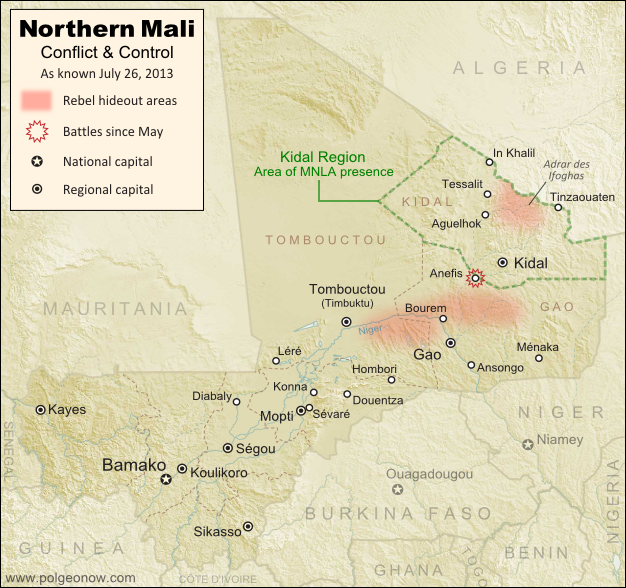
Updated map of fighting and territorial control in Mali during the 2013 French and African intervention against Islamist rebel groups MUJAO, Ansar Dine, and Al Qaeda in the Islamic Maghreb (AQIM). Reflects the situation as of July 27, 2013, including the Kidal region claimed by the Tuareg rebels of the National Movement for the Liberation of Azawad (MNLA).
Updated map of situation in Mali ahead of elections on July 28, 2013. Map by Evan Centanni, modified from Wikimedia map by Orionist, using images by Carport and NordNordWest (source). License: CC BY-SA.

Army Returns to Kidal
As shown on the previous edition of our Mali war map, January’s French intervention against religious extremists returned most of the country to government control, but left the northeastern province of Kidal in the hands of the Tuareg-dominated rebels of the National Movement for the Liberation of Azawad (MNLA). The MNLA had insisted that the Malian army not be allowed into Kidal, citing the army’s alleged abuses against Tuareg and Arab people, leading France to seek negotiations between the MNLA and Mali’s central government.

The Malian government likewise insisted that it be allowed into Kidal prior to national elections on July 28th, and the army at one point appeared poised to fight its way in by force, capturing the provincial border town of Anefis in early June. However, after two more weeks, the government and the MNLA signed a formal deal, agreeing to put off questions of autonomy for the north until after the elections. Under the agreement, Mali’s army was allowed to peacefully enter Kidal, and MNLA soldiers returned to their camps.
Flag of MaliCountry Name:  
• Mali (English, French, Bambara)
Official Name:  
• Republic of Mali (English)
• République du Mali (French) 
• Mali ka Fasojamana (Bambara)
Capital: Bamako

U.N. Peacekeeping Mission Begins
A new U.N. peacekeeping mission in Mali, called MINUSMA, officially began on July 1st. The mission replaces the international African force already in the country, a coalition of West African neighbor countries plus Chad, under U.N. command. In addition to the U.N. peacekeepers, there are also still 3,200 French troops remaining in Mali.

What About the Islamist Rebels?
Religious extremist rebel groups Ansar Dine and the Movement for Unity and Jihad in West Africa (MUJAO), which last year controlled all of northern Mali, have mostly gone into hiding since the French intervention – Ansar Dine in the Adrar des Ifoghas mountains of Kidal, and MUJAO in the area of Gao and nearby stretches of the Niger River. Al Qaeda’s local branch, AQIM, is also present.

Our last Mali war map showed continuing battles against the rebels even in the north’s major cities, but since May the fighting has mostly come to an end, with the militants avoiding rather than confronting the French army’s ongoing expeditions into the desert. The only major fighting reported since our last update was a clash between MUJAO rebels and the MNLA in Anefis, prior to the town being taken by the Malian army.

Related Articles:
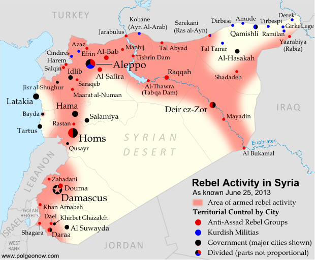
Nigeria War Map: Boko Haram Loses Territory

Graphic of Malian flag is in the public domain (source).

Nigeria Map Update: War on Boko Haram Continues After Decline in Rebel Control

There are newer versions of this map available. To see them, view all Nigeria updates.

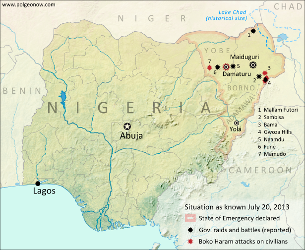
Two months ago, Political Geography Now published a map of Boko Haram rebel control in Nigeria as the government declared a state of emergency and began a large-scale military intervention. We now present an updated map of the continued fighting and attacks following the rebels’ apparent loss of any significant territorial control.

Map of battles, government raids, and rebel attacks in Nigeria's war with Boko Haram and declared state of emergency. Updated for July 2013.
Map of fighting and attacks in Nigeria’s war against the rebels of Boko Haram. Map by Evan Centanni.

Boko Haram Loses Territorial Control
As shown in our first map of the Boko Haram rebellion in Nigeria, a few months ago the rebels reportedly had actual territorial control of several areas of the country’s northeast. Details of events related to Nigeria’s military crackdown are sometimes fuzzy due to communications blackouts and lack of press access; but according to government reports, Boko Haram’s bases have been decimated by the ongoing intervention, and the region has generally fallen back under government control.

Boko Haram is a decade-old rebel movement which seeks to banish all Western education and influence in favor of strict Islamic law for Nigeria’s north.

Flag of NigeriaCountry Name:  
• Nigeria*
Official Name:  
• Federal Republic of Nigeria*
Capital: Abuja
*There are hundreds of languages spoken in Nigeria, but only English is official.

Continued Fighting
Though the rebels have reportedly been mostly driven from their bases, they have not given up or fled Nigeria entirely. Compared to a few months ago, violence seems to have abated along the former shores of Lake Chad in favor of moving into the region’s hills and urban centers.

Nigerian government forces have launched raids targeting Boko Haram guerrillas in the Sambisa forest and Gwoza Hills of southeastern Borno State, Mallam Futori near the northern border, and locations such as Ngamdu and Fune in the neighboring state of Yobe. There have also been multiple major battles in the Borno State capital city of Maiduguri. Adamawa, the third Nigerian state in which the state of emergency was declared, has been relatively quiet.

Boko Haram Attacks
Meanwhile, the Boko Haram rebels have been defying the Nigerian army by continuing to launch bloody attacks on civilian targets in Borno and Yobe. Most infamous are two recent massacres at high schools in Mamudo and the Yobe state capital of Damataru, which the rebels say are a necessary part of their struggle against Western education. They have also sacked villages in the Gwoza Hills, as well as the nearby towns of Gwoza and Bama. Nigerian government forces have also been accused of serious human rights abuses.

The government of Nigeria claimed last week that a ceasefire deal with Boko Haram was under negotiation, but the head of the rebel group, Abubakar Shekau, later denied this.

Related Articles:

Graphic of the Nigerian flag is in the public domain (source).
Egypt Suspended from African Union

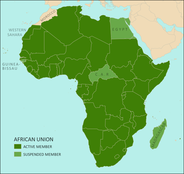
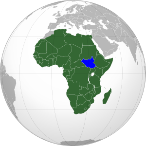
Map of the African Union, including active and suspended members, updated for the July 2013 suspension of Egypt (colorblind accessible).
The African Union. Map by Evan Centanni, from this blank map by Eric Gaba. License: CC BY-SA

Flag of the Arab Republic of Egypt Country Name:  
• Egypt (English)
Miṣr (Arabic)
Official Name:  
• Arab Republic of Egypt (English)
• Ǧumhūriyyat Miṣr al-ʿArabiyyah (Arabic)
Capital: Cairo

Article by Evan Centanni

African Union Suspends Egypt
Egypt, the third most populous country in Africa, was suspended last weekend from that continent’s regional organization, the African Union (AU). The suspension comes after months of unrest in the country, in which massive popular protests led to the military overthrow of the government last week. The suspension is being taken very seriously by the parties involved.

The AU’s Peace and Security Council typically suspends member countries when they experience coups or other breakdowns of constitutional rule. Egypt joins three other African countries which are also currently suspended for similar incidents: Madagascar, Guinea-Bissau, and the Central African Republic (CAR) (see the links for information on each country’s constitutional crisis).

See Also: Rebel Takeover of Central African Republic (map)

What is the African Union?

Flag of the African Union (AU)Organization Name:  
• African Union (English)
• al-Āthḥād al-’Āfrīqī (Arabic)
• Union africaine (French)
• União Africana (Portuguese)
• Unión Africana (Spanish)
• Umoja wa Afrika (Swahili)  
Launched: 2002 in Durban, South Africa
Headquarters: Addis Ababba, Ethiopia
Website: www.au.int

Formed in 1999-2002 to replace the earlier Organization of African Unity (OAU), the AU is an intergovernmental organization which works on increasing cooperation, stability, and development within the continent of Africa. It has a secretariat based in Addis Ababa, Ethiopia, though many of its most important decisions are made during annual summits of the continent’s national leaders.

Every UN-recognized country in Africa is a member of the African Union except for Morocco, which withdrew from the OAU in 1984 after the organization chose to admit the partially recognized state of Western Sahara, a disputed territory which Morocco claims and largely occupies. The only other parts of Africa not represented in the AU are a few groups of offshore islands controlled by European countries, as well the small Spanish enclaves in North Africa. The breakaway Republic of Somaliland is not a member, but is considered by the AU to be part of Somalia.

Low-resolution graphic of the African Union flag is displayed under fair use principles (source).

Related Articles:

Croatia Joins EU, Leaves CEFTA

Croatia Joins EU, leaves CEFTA

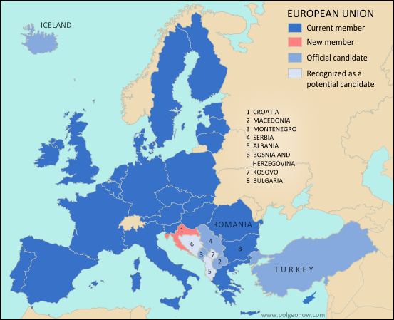
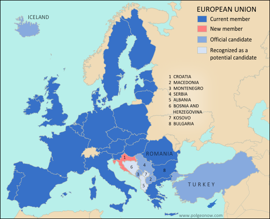
Map of the European Union (EU), highlighting new member Croatia, candidate countries with applications pending, and potential future candidates (colorblind accessible).
The European Union. Map by Evan Centanni, from this blank map by Ssolbergj. License: CC BY-SA

Flag of Croatia Country Name:  
• Croatia (English)
Hrvatska (Croatian)
Official Name:  
• Republic of Croatia (English)
• Republika Hrvatska (Croatian)
Capital: Zagreb

Article by Evan Centanni

Croatia Joins the European Union
The southeastern European country of Croatia officially became a part of the European Union (EU) on Monday. Croatia is the 28th member country of the EU, and the first new one to join since Romania and Bulgaria in 2007. Formerly a part of communist Yugoslavia, Croatia secured its independence in the bloody Yugoslav Wars of the 1990s. It is only the second of those former Yugoslav countries to successfully join the European Union (after Slovenia), despite all of them being interested. Though Croatia is now an official EU country, it has not yet joined the Schengen Area or the Eurozone.

Croatia’s application to join the EU was first submitted ten years ago, and since then the country has been in the process of meeting the requirements set for it by existing EU members. One of the last milestones achieved was the commission of an arbitration tribunal for resolving a sea border dispute with neighboring Slovenia, which had used its own EU membership to demand this as one of the terms of Croatia’s admission.

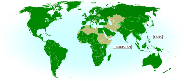
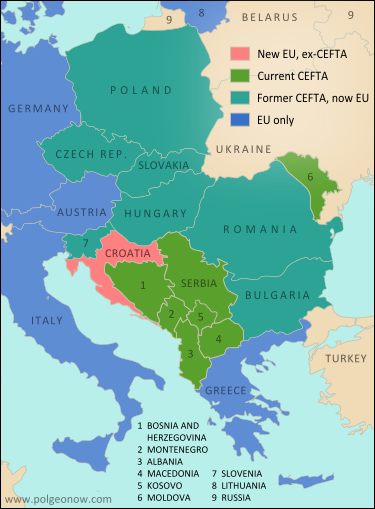
Map of member countries of the Central European Free Trade Agreement (CEFTA), highlighting newly departed Croatia and also showing other former members which have since joined the European Union (colorblind accessible)
Member countries of the Central European Free Trade Agreement (CEFTA), which Croatia has just left by joining the EU. Map by Evan Centanni, from this blank map by Ssolbergj. License: CC BY-SA

Further Reading: Accession of Croatia to the European Union

Who’s Next?
There are currently eight more countries seeking to join the EU, though none has yet secured an admission date. Turkey, Iceland, Serbia, Montenegro, and Macedonia have all been approved as official candidate countries. Meanwhile, Albania has submitted its application, and two other Balkan countries – Bosnia and Herzegovina and partially recognized Kosovo – are officially listed as potential future candidates.

Further Reading: EU Enlargement: The Next Eight (BBC)

Leaving CEFTA
By joining the European Union, Croatia is also leaving the Central European Free Trade Agreement (CEFTA), a trade pact including most of the southeastern European countries which have not yet joined the EU. CEFTA includes the majority of the countries currently trying to join the EU, plus Moldova, and used to include many more of the former communist Eastern European states as well. Joining the EU and subsequently leaving CEFTA is an expected eventual outcome for most of its members.

Related Articles:

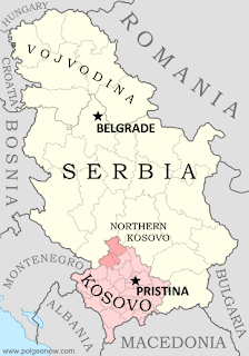
North Kosovo Status Changing after Serbia Deal