Kosovo Recognized by Chad (Total: 91/193)

Map of countries that recognize the Republic of Kosovo as independent, updated for June 2012
Countries recognizing the Republic of Kosovo in green, with the most recent, Chad, in lighter green (click to enlarge). Kosovo in magenta. Map by Evan Centanni, modified from public domain wiki map (source).

Flag of the Republic of KosovoCountry Name:  
• Kosovo (English, Serbian)
• Kosova (Albanian)
Official Name:  
Republic of Kosovo (English)
Republika e Kosovës (Albanian)
Republika Kosovo (Serbian)
Capital: Priština

Kosovo Recognition Update
In the month or so since our last report on Kosovo, one more U.N. member country has offered diplomatic recognition to the breakaway state. Chad, a diverse country in Central Africa, recognized the Republic of Kosovo on June 1, one month after a meeting between their Foreign Ministers. A southeastern European state which seceded from Serbia in 2008, Kosovo is now officially considered independent by 91 U.N. member countries (47%) plus non-member Taiwan. It has not been admitted as a member of the U.N., due to objections from Serbia, Russia, and other countries which consider it to be part of Serbia. For more on Kosovo’s special situation, see Kosovo Diplomatic Recognition Continues.

Stay Updated: Check for more recent posts by viewing all Kosovo articles on Political Geography Now.

Flag graphic by Cradel (source). License: CC BY-SA

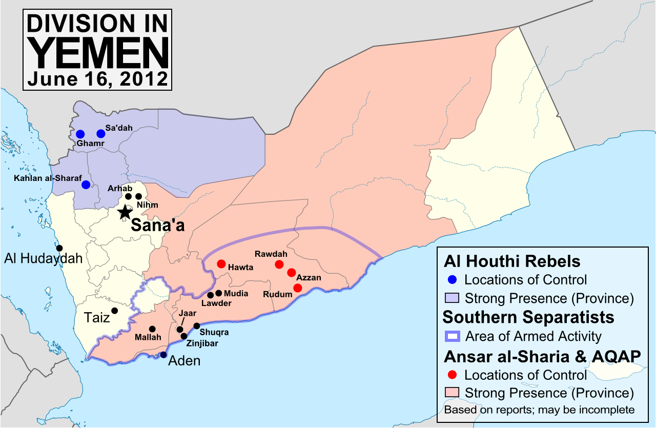
Yemen Conflict: Map Update 3

Fighting between Yemen’s transitional government and Al Qaeda branch Ansar al-Sharia reached a climax this week, as government forces captured the militants’ strongholds in Abyan province. This article gives a rundown of recent events and the current situation in divided Yemen.

Map of division in Yemen, including control by Al Qaeda or Ansar al-Sharia, the Houthi rebels, and the Southern Movement. Update for June 2012.
Presence of anti-government forces in Yemen in June 2012. Ansar al-Sharia is part of Al-Qaeda in the Arabian Peninsula (AQAP). Map by Evan Centanni, using this blank map by NordNordWest/Wikipedia (license: CC BY-SA).

Note: To see previous Yemen map updates, or to check for new ones, view all Yemen posts on Political Geography Now.

Yemen vs. Al Qaeda

In the three months since our last Yemen update, the national army has been engaged in heavy fighting against Ansar al-Sharia, a front group of Al Qaeda in the Arabian Peninsula (AQAP) which has controlled large areas of Yemen’s south since the chaos of last year’s popular uprising. In some southern towns, Ansar al-Sharia has set up “Islamic Emirates” administered independently of Yemen’s government, with its two most prominent strongholds in Zinjibar and Jaar (renamed “Waqar”).

Flag of Al Qaeda, flown by Ansar al-Sharia in its Islamic emirates in southern Yemen.
Flag flown by Ansar al-Sharia in its emirates – the war banner of Al Qaeda, based on Muhammed’s Black Standard. Public domain graphic by Ingoman (source).

The Al Qaeda fighters at first defied the Yemeni forces, taking new territory in Shabwah province’s Rudum District, and temporarily capturing an army base in the area of Mallah at the end of March. They have also gradually expanded operations into Marib province and the southern port city of Aden. However, the tables began to turn in May, as the government of President Abdo Rabbuh Mansur Al-Hadi launched a major offensive against the Islamic extremists – with support from the U.S., including air strikes by armed drones.

First, Ansar al-Sharia was completely driven out of the Lawder and Mudia areas, whose town centers had already been defended for many months by “Popular Resistance Committees” (community militias opposed to Al Qaeda, who also played a key role in the recent victory). Then, early this week, Yemen’s army finally captured Zinjibar and Jaar, key strongholds which the militants had held for over a year. The last Al Qaeda territory in Abyan province, the port town of Shuqra, fell into government hands on Friday. The neighboring province of Shabwah remains largely under the control of Ansar al-Sharia, though none of their “emirates” there are as strategically useful as Jaar or Zinjibar.

Other Rebels in Yemen
The Houthi rebels, an army of Zaidi Shiite dissidents who have been fighting the government for years, still control most of Sa’dah province in the north, and exert their power in the surrounding regions as well. They refused to put down their weapons when Yemen’s popular uprising ended in February, but have agreed to join upcoming talks on the future of the country. Efforts are under way to convince the Southern Movement secessionists to join the dialogue as well.

Meanwhile, fighting has sprung back up between the Yemeni military and local militias in the north of the capital, Sana’a. The districts of Arhab and Nihm, which fought in solidarity with anti-government protesters during much of last year, have once again been shelled repeatedly by the military. This action strikes a sharp contrast with President Hadi’s efforts at national unity, and it has been alleged that the conflict is being waged in defiance of the president’s orders by Ahmed Ali Abdullah Saleh, commander of the Republican Guard and son of the deposed former president.

Map showing the location of Yemen on a globe
Location of Yemen (public domain; source)

Appendix: Alternative Spellings
Because there is no single standard way to spell Arabic names in English, many of the place names in this article have multiple possible spellings. Here are some alternate spellings used in the media:

Jaar – Ja’ar
Lawder – Lawdar, Loder
Mudia – Maudia, Mudiya, Mudiyah, Modia
Rudum – Radum
Sa’dah – Saadah, Saada
Shuqra – Shuqrah, Shaqra, Shaqrah, Shakra
Zinjibar – Zunjubar

Feature: Queen Elizabeth’s 16 Countries

Did you know that Elizabeth II is not just the Queen of England and the UK, but of 15 other independent countries too? Read on for quick answers to all your questions about this unusual arrangement…
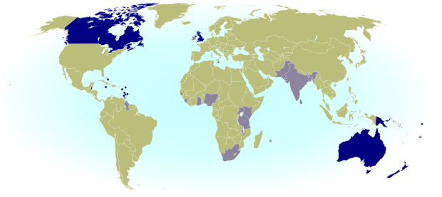
Map of the Commonwealth Realms - independent countries that share the British monarchy.
Map of the Commonwealth realms – independent countries which share the British monarchy. Current realms in dark blue, former realms in light blue. By Evan Centanni, modified from public domain Wikipedia map (source).

Which countries share the Queen?
Her Majesty Queen Elizabeth II is the official head of state for 16 different independent countries, known as the “Commonwealth realms” – a smaller club than the Commonwealth of Nations, many of whose members are now queenless republics. The current Commonwealth realms, in order of independence, are:

Personal flag of Queen Elizabeth II
Personal flag of Queen Elizabeth II (source) License: CC BY-SA.

 United Kingdom
 Canada
 Australia
 New Zealand
 Jamaica
 Barbados
 The Bahamas
 Grenada
 Papua New Guinea
 Solomon Islands
 Tuvalu
 Saint Lucia
 Saint Vincent and the Grenadines
 Belize
 Antigua and Barbuda
 Saint Kitts and Nevis

Just as the sun never sets in the British Empire, the monarchy never set in the realms – each one inherits the queen’s role from its time as a former British colony (with the exception of northern Papua New Guinea, which passed directly from German to Australian control before uniting with the British south in independence).

Sixteen countries – is that all?
Although the independent realms total 16, the number of “countries” with Elizabeth II as their queen actually increases to 19 when including the four “home nations” that make up the U.K.: England, Scotland, Wales, and Northern Ireland. But that’s not all – as if 16 realms weren’t enough for one woman, the Queen of England also reigns over three Crown Dependencies (Guernsey and Jersey in the Channel Islands, plus the Isle of Man) and the 14 British Overseas Territories, all of which are dependent on the U.K., but aren’t considered part of the kingdom itself. And interestingly, the Realm of New Zealand includes two associated states, the Cook Islands and Niue, which could remain royal subjects even if New Zealand itself were to fire the queen from its government.
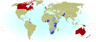
Map of the entire reign of Queen Elizabeth II (1952-2012), marking current and former realms and territories.
Entire reign of Queen Elizabeth II (1952-2012). Current in red, former in blue (dark = sovereign realm; light = territory or dependency). Click to enlarge. Excludes Antarctic claims. By Evan Centanni, from public domain map (source).

Historically, there are about 20 more countries which were Commonwealth realms during parts of the last Century, but have since abandoned the monarchy to become republics. Still, the current list is longer than it used to be – at the time of Queen Elizabeth II’s coronation in 1952, there were only seven realms: the U.K., Australia, Canada, New Zealand, Pakistan, South Africa, and Ceylon (now Sri Lanka).


How can countries share the same monarch and still be sovereign states?
Every one of the Commonwealth realms is a fully-fledged independent country and a member of the U.N., despite sharing the same queen. So how does that work? Each country has separately and independently designated Elizabeth II (and her royal line) as its head of state, and the British parliament has no authority whatsoever over the governments of any of the other realms. In a certain legal sense, these 16 countries just happen to have chosen the same family to form their monarchy.

To show this independence, each realm calls the queen by its own national title – she is not only the the Queen of England, but the Queen of Australia, the Queen of Canada, the Queen of the Bahamas, etc. As for Her Majesty, she’s been said to be “equally at home in all of her realms”. But since she has only has one physical body, she still mainly lives in the oldest realm: the U.K. In her other countries, she’s represented on an everyday basis by appointed viceroys (the highest-level viceroys are called governors-general).

But if they’re all controlled by the same person, isn’t that like being one country?

Flag of Elizabeth II, Queen of Barbados
Flag of Elizabeth II, Queen of Barbados. See all flags of Elizabeth II. By Barryob (source). License: CC BY-SA.

Unlike in medieval personal unions, where a single monarch had power over two or more countries, the queen has next to no power in her modern realms. Although there are some decision-making powers ceremonially assigned to her, for the most part she can now only exercise them if asked to by the country’s government. Since modern constitutional monarchies require the royal family to stay out of politics, the queen serves as a symbol of a loyalty to one’s nation that transcends political differences.

Still, this must create some awkward situations now and then, right?
Absolutely – since the queen mainly acts only on the “advice” of her countries’ governments, she officially takes both sides whenever two realms disagree, and has also been found engaging in trade competition with herself. She may also be simultaneously neutral and at war when one realm is involved in an international conflict and others are not; in extreme cases, the monarch of the Commonwealth realms may even declare war against him or herself, as happened in the Indo-Pakistani War of 1947 (during the reign of King George VI).

Learn More: The Commonwealth of Nations includes a lot more than just the Realms – so what is it, exactly?

Syrian Uprising: Update 4

There are newer versions of this map available. To see them, view all Syria updates.

Full Story: See Syria Divided by Armed Conflict

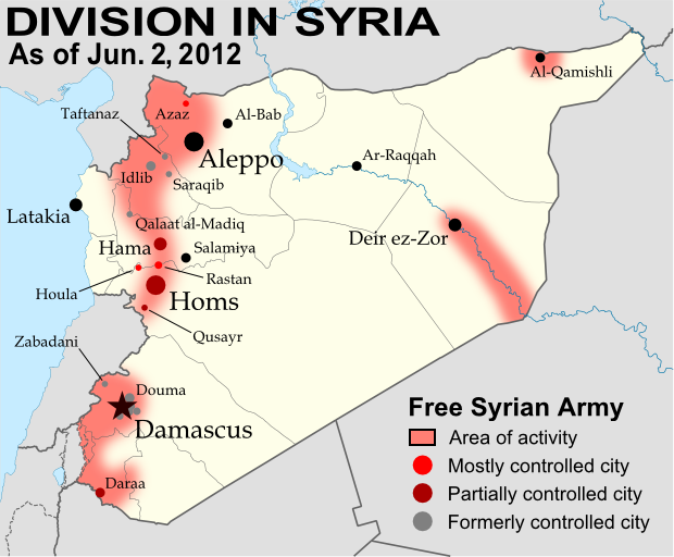
Map of Syria's uprising, marking cities and towns under control of the Free Syrian Army rebels as of June 2, 2012. Includes the site of the recent Houla massacre.
Known areas of armed activity for the rebel “Free Syrian Army” (click to enlarge). My own work, starting from this blank map by NordNordWest. License: CC BY-SA

Wondering what’s been going on in Syria since our last map update? There have been few, if any, major changes in territorial control, but here’s a brief status update. 

Despite the U.N. brokered ceasefire between the Syrian military and the rebel Free Syrian Army, which was to enter in effect on April 10, armed clashes have continued in many parts of the country, including recent heavy fighting in Rastan. Bloodshed reached a horrific peak a week ago, as over one hundred civilians – nearly half of them children – were massacred in the Houla area of Homs province. Witnesses told the U.N. that the murders were committed by militias loyal to President Assad, though the Syrian government attempted to blame the atrocity on the rebels. In the aftermath, one commander of the Free Syrian Army threatened to call off the ceasefire altogether, which could mean increased fighting in the coming weeks.

Country Name:  
• Syria (English)
• Sūriyya/Sūryā (Arabic)
Official Name:  
• Syrian Arab Republic (English)
• al-Jumhūriyyah al-‘Arabīyah  as-Sūriyyah (Arabic)
Capital: Damascus

Territorial control by the government and rebels has remained mostly the same since April. The only change made to the map is the addition of Houla in red, as at least one source indicates the area was under rebel control both before and after the massacre. Note that the Free Syrian Army is also reported to control much of the northwestern Idlib province outside of the main cities, though the situation is fluid and information is scarce, making it difficult to mark anything definitively on the map.