Map of Boko Haram/”Islamic State” Control in Nigeria: October 2015

(To see other maps in this series, view all Boko Haram updates on PolGeoNow.)

Detailed map of Boko Haram (Islamic State West Africa Province) territorial control in its war with Nigeria, marking each town reportedly under the group's control. Includes key recent locations, including Dikwa, Banki, the Sambisa Forest, and targeted areas on Lake Chad and the borders of Cameroon and Niger.
Map by Evan Centanni. All rights reserved.

(Subscribers click here to view this article in the member area) 

By Evan Centanni

The “Islamic State” in Nigeria
Northeastern Nigeria’s Boko Haram rebels, despite being pushed out of most of the territory they held last year, are still a major force in the region.

After becoming an official affiliate of Iraq and Syria’s so-called “Islamic State” (IS, a.k.a ISIS/ISIL) last March, they have now taken to calling themselves the Islamic State’s West Africa Province (ISWAP).

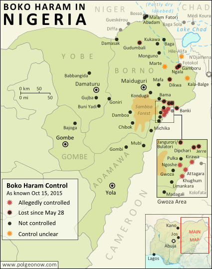
Status of Territorial Control
The goal of IS is to capture and hold territory, and Boko Haram still hangs on by a thread in that respect. Though the extent of their control has been blurry over the past six months (there is extremely little independent reporting from the region), military forces of Nigeria and neighboring countries have continued to announce the “recapture” of towns – an implicit acknowledgment that territory continues to be hotly contested.

Since this summer, the Nigerian government has stepped up aerial attacks against Boko Haram hideouts in the Sambisa Forest, but the result seems to have been a flood of fighters into nearby communities on border with Cameroon, while the forest remains an area of murky control.

Flag of NigeriaCountry Name:  
• Nigeria (English)*
Official Name:  
• Federal Republic of Nigeria (English)*
Capital: Abuja
*There are hundreds of local and regional languages in Nigeria, but only English has official status.

Chronology of Events
The following is a timeline of major events and changes to territorial control in northeastern Nigeria and neighboring countries since our previous update of May 28, 2015.

Note that Boko Haram launches deadly attacks on an almost daily basis across northeastern Nigeria, frequently on Cameroon’s side of the border, and occasionally in Niger and Chad as well. This timeline focuses on changes of territorial control, adding in selected items representing the biggest news and most significant cross-border incidents.

2015.06.14 Boko Haram fighters sacked the town of Babbangida, north of Yobe state capital Damataru.

2015.06.15 Boko Haram carried out a bombing with heavy casualties in N’Djamena, the capital city of Chad. An important Boko Haram leader would be captured in the city two weeks later.

2015.06.17-23 A deadly Boko Haram attack on Gueskérou, Niger was answered with a five-day long air and ground campaign by that country’s armed forces.

2015.07.01-02 Boko Haram killed almost 200 people in two days, in a wave of attacks across Borno state. As of last March, Boko Haram considers itself the West African branch of the Syria- and Iraq-based “Islamic State” (a.k.a. ISIS/ISIL). The July violence in Nigeria, targeted at non-extremist Muslims, coincided with an IS directive to increase attacks during the Muslim holy month of Ramadan.

2015.07.22 A village in the Hile-Alifa area of Cameroon was reportedly occupied by Boko Haram, two days after a brutal rebel attack on the nearby town of Kamouna.

2015.07.24 The Nigerian army said it recaptured Dikwa from Boko Haram, though the town had already been reported secured by Chadian forces in March.

2015.07.25 Boko Haram attacked the island of Médi Koura among the fragmented remains of Lake Chad, well within the borders of Chad itself. The attack would be followed by major military campaign and heavy fighting in nearby areas, as Chadian troops attempted to drive Boko Haram forces entirely out of the lake region.

2015.08.02 The Nigerian army said it rescued 178 prisoners from Boko Haram, most of them children and women. The 200 missing girls infamously kidnapped from Chibok in 2014 were not among them.

2015.08.21 An army source reported that troops had driven Boko Haram fighters out of Gudumbali.

2015.09.01 Nigerian government forces captured Gamboru-Ngala from Boko Haram. The twin towns had been secured by Chadian forces months earlier, but not protected from subsequent rebel incursions.

2015.09 In early September, Boko Haram fighters began attacking communities on the border with Cameroon after being flushed out of the Sambisa Forest by a heavy government bombing campaign. The attacks included the storming of a market in downtown Kirawa, a town known to have been under Boko Haram control in the past.

2015.09.19 A military spokesman said Nigerian troops had captured Jerre and Dipchari, on the road to Banki.

2015.09.20 A Nigerian newspaper reported that Boko Haram was operating a checkpoint on the road between Gwoza and Limankara, killing any travelers who did not have food to offer to the rebels.

Map of Boko Haram control in Nigeria in March 2015, and the multinational offensive with Cameroon, Chad, and Niger that drove the rebels back.
Multinational offensive against Boko Haram, Jan. to Mar. 2015

2015.09.22 Nigerian troops cleared Boko Haram fighters from camps in Jangurori and Bulatori, near Bama. In the process a high-level Boko Haram leader was captured.

2015.09.24 The Nigerian military said it seized Banki, on the border of Cameroon, with cooperation from the Cameroonian military. The next day, “at least 200” Boko Haram fighters allegedly surrendered to the government forces.

2015.09.23-25 Madagali, at the northern tip of Adamawa state, was reportedly abandoned by its population after three consecutive days of Boko Haram raids.

2015.10.07 The military claimed that over 100 Boko Haram fighters were killed in a failed attack on troops in Goniri, on the Borno-Yobe state line.

2014.10.08 An open letter from displaced residents to President Buhari said Boko Haram was in control of a number of villages east of Gwoza, including Ngoshe, Attagara, Kirawa, and Kughum.

2014.10.10 Dozens were killed in a Boko Haram attack on a fish market in Baga Sola, on Chad’s side of the border.

2015.10.14 The US announced it was sending 300 troops to Cameroon to assist in tracking down Boko Haram fighters.

Following this story? View all Boko Haram maps on PolGeoNow!

Timeline compiled with the help of the ACLED dataset (Raleigh, Clionadh, Andrew Linke, Håvard Hegre and Joakim Karlsen. 2010. Introducing ACLED-Armed Conflict Location and Event Data. Journal of Peace Research 47(5) 651-660.)

Graphic of the Nigerian flag is in the public domain (source).

Map of Boko Haram Control in Nigeria: March 2015 (Subscription)

The best online map of Boko Haram’s territorial control – guaranteed!

There are newer versions of this map available. To see them, view all Boko Haram updates.

Detailed map of Boko Haram's territorial control in its war with Nigeria, marking and labeling each town reportedly under the group's control in Borno, Yobe, and Adamawa states. Includes illustration of multinational campaign against the group by Nigeria, Chad, and Niger.

Download PDF:
Buy now

(Subscribe via Paypal to view all premium content online)

Research by T.H., with additional reporting by Evan Centanni

Boko Haram has now allegedly teamed up with the Islamic State, but the Nigerian rebel group has recently lost most of its territory to a multi-pronged military campaign involving Nigeria, Chad, Niger, and Cameroon.

This map report illustrates the offensive against Boko Haram and the rebel group’s remaining territorial holdings, and includes a summary and timeline of events since our previous Boko Haram map report in January.

This map report is exclusive premium content, available to paid subscribers or for separate purchase. Buy now (US$14.99)

Exclusive map report includes:

  • Map of Boko Haram’s overall area of control in Nigeria, updated to March 22, 2015.
  • Detailed map showing almost every individual town currently or previously held by Boko Haram, as well as the overall extent of rebel territorial control.
  • Illustrations of the five major military campaigns that have driven Boko Haram back over the past two months, as well as key locations in neighboring countries.
  • Summary and detailed timeline of territorial changes and major events since late January, with links to sources.

MEMBERS CLICK HERE TO PROCEED TO ARTICLE AND MAP

NOT A MEMBER YET? SUBSCRIBE NOW!

Nigeria War Update: Map of Boko Haram Control (January 2015) (Premium)

The best online map of Boko Haram’s territorial control – guaranteed!

There are newer versions of this map available. To see them, view all Nigeria updates.

Detailed map of Boko Haram's territorial control in its war with Nigeria, marking and labeling each town reportedly under the group's control in Borno, Yobe, and Adamawa states. Includes recent flashpoints such as Maiduguri, Damataru, Konduga, and Monguno, as well as sites of attacks in Cameroon.

Download PDF
Buy now

(Subscribe via Paypal to view all premium content online)

Research by T.H., with additional reporting by Evan Centanni

Since our last Boko Haram control map update in November, the rebel group has expanded its territorial control in Nigeria, connecting two of its territorial enclaves and occupying a long stretch of the country’s international border with Niger, Chad, and Cameroon.

This premium report and map detail the various changes of the past two months, including new Boko Haram conquests as well as key attacks that didn’t result in territorial gains. The map also, of course, provides an updated illustration of the full extent of Boko Haram’s territorial control.

This map and article are exclusive premium content, available only to paid members or for individual purchase. Buy now (US$9.99)

Premium report includes:

  • Map of Boko Haram’s overall area of control in Nigeria, updated to Jan. 28, 2015.
  • Detailed map showing almost every individual town or village known to be held by the group, as well as recent locations of major attacks, such as Baga, Monguno, Maiduguri, and Damataru. 
  • Also shows attacks across the border in Cameroon.
  • Summary and detailed timeline of territorial changes and major events since late November, with sources cited.

MEMBERS CLICK HERE TO PROCEED TO ARTICLE AND MAP

NOT A MEMBER YET? SUBSCRIBE NOW!

Mali Conflict Map: National Territory Reunited Ahead of Elections (July 2013)

There are newer versions of this map available. To see them, view all Mali maps. 

This is an update within our Mali conflict map series – for the original story, see Mali Map: Islamist Control & French Intervention

Updated map of fighting and territorial control in Mali during the 2013 French and African intervention against Islamist rebel groups MUJAO, Ansar Dine, and Al Qaeda in the Islamic Maghreb (AQIM). Reflects the situation as of July 27, 2013, including the Kidal region claimed by the Tuareg rebels of the National Movement for the Liberation of Azawad (MNLA).
Updated map of situation in Mali ahead of elections on July 28, 2013. Map by Evan Centanni, modified from Wikimedia map by Orionist, using images by Carport and NordNordWest (source). License: CC BY-SA.

Army Returns to Kidal
As shown on the previous edition of our Mali war map, January’s French intervention against religious extremists returned most of the country to government control, but left the northeastern province of Kidal in the hands of the Tuareg-dominated rebels of the National Movement for the Liberation of Azawad (MNLA). The MNLA had insisted that the Malian army not be allowed into Kidal, citing the army’s alleged abuses against Tuareg and Arab people, leading France to seek negotiations between the MNLA and Mali’s central government.

The Malian government likewise insisted that it be allowed into Kidal prior to national elections on July 28th, and the army at one point appeared poised to fight its way in by force, capturing the provincial border town of Anefis in early June. However, after two more weeks, the government and the MNLA signed a formal deal, agreeing to put off questions of autonomy for the north until after the elections. Under the agreement, Mali’s army was allowed to peacefully enter Kidal, and MNLA soldiers returned to their camps.

Flag of MaliCountry Name:  
• Mali (English, French, Bambara)
Official Name:  
• Republic of Mali (English)
• République du Mali (French) 
• Mali ka Fasojamana (Bambara)
Capital: Bamako

U.N. Peacekeeping Mission Begins
A new U.N. peacekeeping mission in Mali, called MINUSMA, officially began on July 1st. The mission replaces the international African force already in the country, a coalition of West African neighbor countries plus Chad, under U.N. command. In addition to the U.N. peacekeepers, there are also still 3,200 French troops remaining in Mali.

What About the Islamist Rebels?
Religious extremist rebel groups Ansar Dine and the Movement for Unity and Jihad in West Africa (MUJAO), which last year controlled all of northern Mali, have mostly gone into hiding since the French intervention – Ansar Dine in the Adrar des Ifoghas mountains of Kidal, and MUJAO in the area of Gao and nearby stretches of the Niger River. Al Qaeda’s local branch, AQIM, is also present.

Our last Mali war map showed continuing battles against the rebels even in the north’s major cities, but since May the fighting has mostly come to an end, with the militants avoiding rather than confronting the French army’s ongoing expeditions into the desert. The only major fighting reported since our last update was a clash between MUJAO rebels and the MNLA in Anefis, prior to the town being taken by the Malian army.

Related Articles:

Nigeria War Map: Boko Haram Loses Territory

Graphic of Malian flag is in the public domain (source).

Mali Conflict Map: Hardline Rebels on the Run, Separatists Rebounding (May 2013)

There are newer versions of this map available. To see them, view all Mali maps.  

This is an update within our Mali conflict map series – for the original story, see Mali Map: Islamist Control & French Intervention.

Updated map of fighting and territorial control in Mali during the 2013 French and African intervention against Islamist rebel groups MUJAO, Ansar Dine, and Al Qaeda in the Islamic Maghreb (AQIM). Reflects the situation as of May 4, 2013, including areas occupied by Tuareg rebels of the National Movement for the Liberation of Azawad (MNLA).
Updated map of territorial control and fighting in Mali, as of May 4, 2013. Map by Evan Centanni, modified from Wikimedia map by Orionist, using images by Carport and NordNordWest (source). License: CC BY-SA.

Towns Cleared of Islamist Rebels
Since our last Mali update in February, the country’s religious extremist rebel groups have continued their retreat from the northern cities that they controlled for half a year. The military intervention by France and Mali’s neighbors has somewhat reunited the country, though with some important exceptions.

In Mali’s far northeast, French and Chadian forces have driven Ansar Dine and Al Qaeda in the Islamic Maghreb (AQIM) out of the important towns of Aguelhok and Tessalit, afterwards seeing heavy combat in the nearby mountains of the Adrar des Ifoghas, where Chad claims to have killed two key regional Al Qaeda leaders. Though many rebels are said to have fled the country, some are still holed up deep in the mountains, and have launched terrorist attacks on the regional capital of Kidal.

More information: Regular situation reports from the French army (in French)

Northern Mali’s biggest city, Gao, was secured by French forces early in the intervention, and is now patrolled by troops from Mali and other African countries. However, the Al Qaeda-offshoot rebels of the Movement for Unity and Jihad in West Africa (MUJAO), who ruled the city for months, have continued their resistance, initiating two major battles in Gao during February, and another in March. Timbuktu has faced similar attacks, which have been variously attributed to either MUJAO or AQIM.

Flag of MaliCountry Name:  
• Mali (English, French, Bambara)
Official Name:  
• Republic of Mali (English)
• République du Mali (French) 
• Mali ka Fasojamana (Bambara)
Capital: Bamako

MUJAO fighters are now based in the villages and countryside surrounding Gao, especially just across the River Niger and in the valleys to the northeast, where French soldiers have been involved in lethal confrontations with the militants. The stretch of the River Niger between Gao and Timbuktu has also seen MUJAO activity, but at least one major town along the route, Bourem, has been secured by the allied forces.

Photos: Mali Conflict Enters New Phase (The Atlantic)

Kidal, Azawad, and the MNLA
The National Movement for the Liberation of Azawad (MNLA), a secular rebel organization made up mostly of people from the Tuareg ethnic group, has sprung back to life in Mali’s far northeast. It now occupies most of the Kidal region, including the capital and key towns, cooperating with the French and Chadian armies but forbidding Malian troops from entering.

The group, which initiated the rebellion in northern Mali last year – declaring an independent country called “Azawad” before being pushed out by Ansar Dine and MUJAO – now seeks again to negotiate with the Malian government. It has ceased its explicit calls for independence, even saying it “recognizes the borders” of Mali, though it has since begun issuing official “Republic of Azawad” documents to drivers passing through Mali’s far northeast.

This second rise of the MNLA was made possible by concerns that Malian soldiers were abusing, and in some cases murdering, Tuareg civilians in the cities they had retaken. Kidal, unlike Gao and Timbuktu, actually has a Tuareg majority, and the MNLA is relatively popular there. After the extremist Ansar Dine rebels fled from Kidal ahead of the French advance, the MNLA welcomed the foreign troops, cooperating with the soldiers from France and Chad. The Malian army, apparently sensing it’s not welcome, has mostly not entered the region.

The MNLA now operates a checkpoint in Anefis, on the border of Kidal and Gao regions, and has defended itself against other rebel groups in the surrounding desert as well as in the town of In Khalil on the border of Mali and Algeria. In February, the MNLA also claimed control of Menaka in Gao region, but the town is now known to be under the control of African troops from neighboring Niger.

Northern Mali: Looking Forward
The future is not at all certain for Mali’s north, with Islamist militants still active and the MNLA calling for greater autonomy against the wishes of the Malian government. Deepening the uncertainty, France and Chad, by far the two strongest armies currently in Mali, are both beginning to withdraw their forces, not wanting to become stuck in an ongoing guerrilla war. However, there’s still hope for Mali not to descend back into chaos; the U.N. security council has authorized a peacekeeping mission to take over starting from July, which will work under the name Multidimensional Integrated Stabilization Mission in Mali (MINUSMA).

Related Articles:

Central African Republic: Map of Rebel Advance to Capital

Graphic of Malian flag is in the public domain (source).

Mali Conflict Map: French Take Kidal, Other Towns (February 2013)

There are newer versions of this map available. To see them, view all Mali maps.  

This is an update of our Mali conflict map – for the original story, see Mali Map: Islamist Control & French Intervention.

Updated map of fighting and territorial control in Mali during the January-February 2013 French intervention against the Islamist extremist rebel groups Ansar Dine and MUJAO. Reflects the situation as of February 2, when Kidal and other towns have been captured by French and African forces.
Updated map of territorial control and airstrikes in Mali, as of Feb. 2, 2013. Map by Evan Centanni, modified from Wikimedia map by Orionist, using images by Carport and NordNordWest (source). License: CC BY-SA.

French Troops Secure Kidal
After taking the two largest cities in Mali’s north over the last week, the French military by Thursday had also secured Kidal, the last of the area’s three major regional centers. The religious extremist rebels of Ansar Dine had apparently already fled the city, which was instead occupied by two moderate rebel organizations, the MIA and the MNLA, the latter of which originally took over the north last spring before being driven out by religious extremist groups.

The MNLA rebels, who were originally a Tuareg-led separatist movement (and even declared an independent country in their territory), have reemerged since the French intervention began, with an apparent willingness to negotiate for limited autonomy within Mali. If fact, they did not resist the French takeover of Kidal, saying they only refuse occupation by the Malian army itself, which they claim has long abused the Tuareg and Arab people of the far north. They also claimed control of a number of towns in the region this week, though journalists have not been able to verify these assertions.

Flag of MaliCountry Name:  
• Mali (English, French, Bambara)
Official Name:  
• Republic of Mali (English)
• République du Mali (French) 
• Mali ka Fasojamana (Bambara)
Capital: Bamako

Meanwhile, two other major towns near Gao have also fallen out of rebel hands. Ansongo was taken on Tuesday by forces from Niger and Mali, while Ménaka was occupied by allied soldiers from Chad. The Chadian contingent makes up nearly half of the African foreign supporting force in Mali, and unlike the others is not a member of the West African regional bloc ECOWAS.

With the capture of all three major northern cities, and reports that most of the Niger River region has also been secured, the first phase of the intervention in Mali is coming to an end. The victorious French and Malian presidents made a celebratory visit to Timbuktu on Saturday, declaring that French soldiers would remain in the country only long enough for African forces to take over the peacekeeping mission.

The extremist rebels have apparently fled into the desert, with Ansar Dine (or what’s left of it after its split with the MIA) believed to be hiding out in the mountains north of Kidal. The only town known to be under their control is Aguelhok, which was targeted by French airstrikes in recent days.

Besides the shrinking strongholds of Ansar Dine, several border areas appear to be under the influence of the MNLA rebels, though as mentioned before, they have not opposed the foreign intervention so far. MUJAO, the other major extremist group which had controlled towns in northern Mali, is apparently nowhere to be seen (for the moment anyway).

Original Story: Mali Map: Islamist Control & French Intervention

Further Reading: 
Islamists’ Harsh Rule Awakened Ethnic Tensions in Timbuktu
Niger agrees to host Mali-bound U.S. spy drones
Reuters Slideshow – Timbuktu Retaken

Additional Source for Map: France24 map – War in Northern Mali

Graphic of Malian flag is in the public domain (source).

Kosovo Recognized by Chad (Total: 91/193)

Map of countries that recognize the Republic of Kosovo as independent, updated for June 2012
Countries recognizing the Republic of Kosovo in green, with the most recent, Chad, in lighter green (click to enlarge). Kosovo in magenta. Map by Evan Centanni, modified from public domain wiki map (source).

Flag of the Republic of KosovoCountry Name:  
• Kosovo (English, Serbian)
• Kosova (Albanian)
Official Name:  
Republic of Kosovo (English)
Republika e Kosovës (Albanian)
Republika Kosovo (Serbian)
Capital: Priština

Kosovo Recognition Update
In the month or so since our last report on Kosovo, one more U.N. member country has offered diplomatic recognition to the breakaway state. Chad, a diverse country in Central Africa, recognized the Republic of Kosovo on June 1, one month after a meeting between their Foreign Ministers. A southeastern European state which seceded from Serbia in 2008, Kosovo is now officially considered independent by 91 U.N. member countries (47%) plus non-member Taiwan. It has not been admitted as a member of the U.N., due to objections from Serbia, Russia, and other countries which consider it to be part of Serbia. For more on Kosovo’s special situation, see Kosovo Diplomatic Recognition Continues.

Stay Updated: Check for more recent posts by viewing all Kosovo articles on Political Geography Now.

Flag graphic by Cradel (source). License: CC BY-SA