War in Nigeria: Map of Boko Haram Control (September 2014)

There are newer versions of this map available. To see them, view all Nigeria updates.

Detailed map of Boko Haram territorial control in its war with Nigeria, marking and labeling each town reportedly under the group's control in Borno, Yobe, and Adamawa states. Includes Damboa, Buni Yadi, Madagali, Gwoza, Gujba, Gulak, Bama, Gulani, Shuwa, Marte, Kukawa, Michika, Dikwa, Bularafa, Bazza, Gambaru Ngala, Buni Gari, Banki, Bara, Pulka, Bumsa, Ashgashiya, Limankara, Njibulwa and more.
Map by Evan Centanni. All rights reserved.

Premium members click here to view this article in the ad-free members area. Not a member yet? Sign up now!

Conflict tracking by T.H., with additional reporting by Evan Centanni

Boko Haram vs. Nigeria
Though it’s waged a bloody war against the Nigerian government for many years, rebel group Boko Haram rarely could claim significant territorial control until recently. Though they did take over a number of remote areas in spring of last year (see our 2013 Boko Haram control map), the militants were soon driven back into hiding by the Nigerian military.

The insurgency never went away, with Boko Haram’s bombings and other attacks, often on schools and other public places, increasing in number and lethality from 2013 into early 2014. (Also see our 2013 report for more background on Boko Haram).

Territorial Resurgence
However, this summer saw a striking change in the trajectory of Boko Haram’s rebellion. Likely inspired by the Islamic State organization in Iraq and Syria, Boko Haram initiated a new strategy of capturing and holding towns and villages. The campaign began in late July, and has gone much farther than last year’s seizure of several small towns. By early September there was talk of an imminent invasion of Maiduguri, the capital of Nigeria’s far northeastern Borno State. That hasn’t happened yet, but neither does Boko Haram seem to be abandoning its newly won territory anytime soon.
Flag of NigeriaCountry Name:  
• Nigeria*
Official Name:  
• Federal Republic of Nigeria*
Capital: Abuja
*There are hundreds of local languages in Nigeria, but only English is official.

Chronology of Events
The following is a timeline of major events and changes to territorial control since Boko Haram began seizing towns in northeastern Nigeria this summer.

2014.04.15 Boko Haram kidnaps hundreds of schoolgirls in Chibok, Borno State, gaining attention from around the world. At this time, Boko Haram is not yet known to hold any clearly-defined territory. As of September 2014, the Chibok girls are apparently still missing, and the town is said to be abandoned.

2014.07 Boko Haram erects tollgates on major routes in northern and central Borno State, where it holds rural influence.

2014.07.21 Boko Haram reportedly captures Damboa, raising its flag over the major Borno town.

2014.07.23 Boko Haram destroys a bridge between Maiduguri and Ngala, Borno State. Current control of Damboa is unclear, but there is no government presence.

2014.07.28 Apparent consensus that Boko Haram controls Damboa and the surrounding local government area

2014.08.03 Around this time, Boko Haram takes over Gujba, its first town captured in Yobe State.

2014.08.06 Boko Haram seizes the key town of Gwoza in Borno.

2014.09.10 Around this time, Boko Haram occupies the town of Ashigashia just outside Nigeria’s borders, in neighboring Cameroon.

2014.08.11 Nigerian government claims to have recaptured Damboa. A month later, the town is reportedly still deserted.

2014.08.17 Over the weekend, Boko Haram reportedly takes control of Michika in Adamawa State, but the town will be more widely reported as captured three weeks later.

2014.08.21 Boko Haram takes Buni Yadi in Yobe State.

2014.08.21 Boko Haram captures Madagali, Adawama State.

2014.08.23 Boko Haram takes over Pulka, Borno State.

2014.08.24 Media report that Boko Haram leader Abubakar Shekau has declared a “caliphate” (Islamic empire) in Gwoza, but he may only have meant that it was now ruled according to Islamic law.

2014.08.25 Boko Haram captures Ngala and Gambaru, Borno State.

2014.08.28 Boko Haram captures Dikwa and Marte, Borno State.

2014.08.29 Cameroon’s military retakes Ashigashia town from Boko Haram.

2014.09.01 Boko Haram attacks Bama, Borno State.

2014.09.02 Bara in Yobe State captured by Boko Haram.

2014.09.02 Boko Haram allegedly captures Bama, a major town in Borno, but the situation remains unclear.

2014.09.03 Boko Haram seizes Banki in Borno State and Gulani in Yobe State.

Map of Boko Haram control in Nigeria in May 2013
Boko Haram control in Nigeria, 2013 (click for free map and report).

2014.09.07 Boko Haram captures town of Gulak, Adamawa State.

2014.09.08 Boko Haram captures Michika, Adamawa State. Government claims to recapture Bama.

2014.09.10 Nigerian military claims to recapture Michika, Uba, and Gulak.

2014.09.11 Bama residents say Boko Haram controls the town, despite continued government insistence to the contrary.

2014.09.13 Unidentified Boko Haram commander reportedly captured during attempt to occupy Konduga.

2014.09.18 Catholic Church source says Boko Haram now controls 25 towns. In addition to locations already mentioned, the list includes Shuwa, Kukawa, Bularafa, Bazza, Buni Gari, Bumsa, Taltaba*, Limankara, and Njibulwa. Michika, Gulak, and Ashigashia are also still listed despite earlier claims they were retaken by government forces. A longer accounting of “31 towns and villages” adds Wulgo, Ngoshe, Attagara, Barawa*, Arbokko, Kirawa.

2014.09.19 Nigerian government begins investigating the possible death of Boko Haram leader Abubakar Shekau. The army of Cameroon also took credit for Shekau’s death, but some believe he was actually killed over a year ago, and that the recent death was of an imposter.

2014.09.26 Boko Haram again tries to capture Konduga, on the way into Borno State capital Maiduguri, but is stopped by government forces.


*PolGeoNow was unable to determine the precise geographical locations of Taltaba and Barawa. For this reason, they do not appear on the above map.

Don’t miss future updates to the map of Boko Haram control in Nigeria! Become a member now!

Graphic of the Nigerian flag is in the public domain (source).

Maps of How Scotland’s Regions Really Voted

Good geographers know that maps can lie to you. Every map emphasizes some aspects of a place at the expense of others, giving it a lot of power to lead careless readers astray. Maps of Scotland’s recent independence referendum are misleading us about the reality, even if not intentionally.

Premium members click here to view this article in the ad-free members area. Not a member yet? Subscribe now!
 

Map of results in Scotland's September 18, 2014 independence referendum. Voters were polled on whether or not to separate from the UK. Map shows relative proportion of yes and no votes for each of Scotland's council areas, using a gradient rather than contrasting colors for small differences.
Map by Evan Centanni, based on blank map by TUBS and NordNordWest (CC BY-SA)

By Evan Centanni

Misleading Maps
By now you’ve probably heard the results of Scotland’s independence referendum: voters chose “no” by a solid margin of 55% to 45%. Check out our previous article to learn more about what would have happened if Scotland had voted “yes”.

Maps like this one from the BBC and this one from Wikipedia have popped up since the results came out, showing how each of Scotland’s council areas voted. Most of the country is in red for “no”, with a few “yes” areas in green.

But if one area went 51% for “yes”, and another 51% for “no”, those two areas actually voted almost identically – yet contrasting red/green maps make us feel like they’re polar opposites (not to mention that one-in-thirty readers has trouble seeing the difference between red and green).

How the Councils Really Voted
Whether each area’s people voted just over or just under 50% in favor isn’t actually that important. What matters is how far the balance was tipped in each region. This is not the U.S. presidential election, where the final vote is actually made by delegates obligated to go by the majority in each state. All the votes across Scotland were pooled together to determine the result, so which side of the 50-yard line each area came out on has no effect .

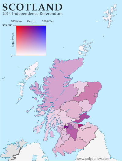
In reality, the vote was split in every part of Scotland. No council area voted more than 58% in favor of independence or more than 68% against. The above map is designed to show how close the vote really was all across the country. Since no area came close to voting completely for independence (blue) or completely against it (red), on this map Scotland’s council areas all end up colored in purplish hues.

For Your Reference: Map of Scotland’s council areas with names labelled

Map of results in Scotland's September 18, 2014 independence referendum. Voters were polled on whether or not to separate from the UK. Map shows relative proportion of yes and no votes for each of Scotland's council areas, using a gradient rather than contrasting colors for small differences and shading to represent the total number of valid ballots case in each region as a way of normalizing for population.
Map by Evan Centanni, based on blank map by TUBS and NordNordWest (CC BY-SA)

The Glasgow metropolitan area, the main region where independence bagged more than half the vote, appears as a slightly bluish purple lump in the bottom-center, while border areas that voted “no” by a larger margin turn out purplish-red (as does Orkney, the group of islands just north of the Scottish mainland). Most of the remaining councils voted more narrowly against independence, showing up in intermediate hues.

Population Matters
In fact, the above map still hides an important factor in the results: the council areas didn’t each have the same number of votes. While turnout was high across the country (75-91%), population varies drastically from council to council. Glasgow city cast nearly 356,000 ballots, while rural Orkney had a mere 14,887.

The second map (at left) tries to show the relative importance of each area in deciding the countrywide result. Here, the same range of purple hues are made lighter or darker depending on how many total valid ballots were cast in each council area. It’s a bit more complicated to read, but the message is clear.

Flag of ScotlandCountry Name:  
• Scotland (English, Scots)
• Alba (Scottish Gaelic)
Current Status:  
Country within the United Kingdom 
Capital: Edinburgh

The outer islands’ voting populations are so small that they look white to the naked eye, with each group contributing only about five percent as many votes as the biggest city. Meanwhile, Scotland’s two major cities of Glasgow (left, bluish) and Edinburgh (right, reddish) stand out sharply with their huge numerical advantage.

The country’s number three city, Aberdeen, seems to have its votes divided between the surrounding Aberdeenshire (large, medium-shaded chunk at upper-right) and the city proper (lighter-shaded kernel along the coast). Meanwhile, the Scottish Highlands, the huge region at upper-left, are sparsely populated but carry some collective clout due to sheer size.

Maps that contrast colors on either side of the 50% mark may be a simple and attention-catching way to show election results, but they mislead us by making countries look more geographically-divided than they really are.

See Also: How Sharply Divided is Ukraine, Really? Honest Maps of Language and Elections

Scottish Independence Poll: What is Scotland, and What Will Happen if it Votes to Leave the UK?

Premium members click here to view this article in the ad-free members area. Not a member yet? Subscribe now!
 

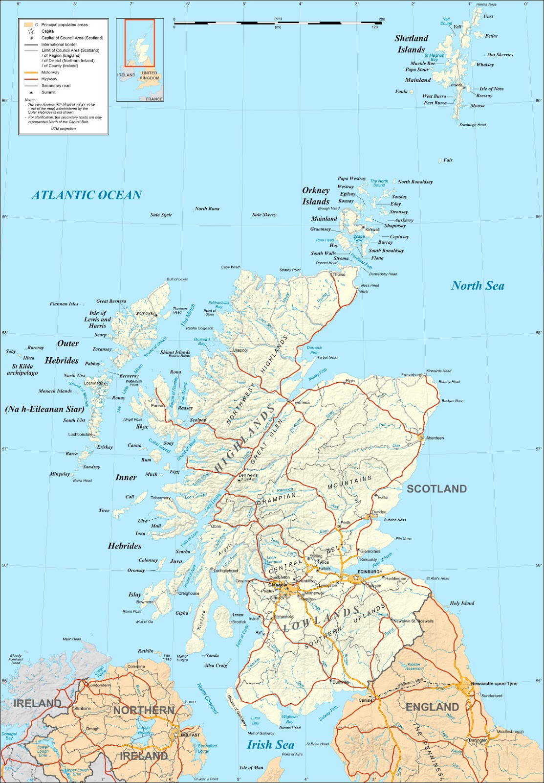
Map of Scotland. On September 18, 2014, Scotland will vote on whether to leave the UK and become an independent country.
Map of Scotland by Eric Gaba (source). License: CC BY-SA

By Evan Centanni

Scotland’s Independence Vote
On Thursday (September 18), residents of Scotland will vote in a referendum on whether to leave the United Kingdom (UK). But is Scotland a country already? What will happen if voters choose “yes” in the referendum? And what other changes would this bring to Scotland and the UK’s political geography? Read on for the answers to these questions and more!

Crash Course: History of Scotland
Scotland is the name of the northern third of Great Britain, the main island of the UK, which is shared with England to the south and Wales to the southwest. It originated as the Kingdom of Alba, an independent Celtic country that was unified around the year 900.

It remained an independent kingdom throughout the Middle Ages, gradually absorbing Anglo-Saxon culture from the south until it came to be ruled by English-speaking monarchs, who called it “Scots” or “Scotland” after the Latin name for the Gaels, the predominant Celtic people of the region.

Starting from the late 1200s, Scotland and England became enemies, and Scotland allied closely with England’s enemy France. But tensions eventually cooled, and in 1603 Scotland’s King James VI inherited the throne of England (where he became known as James I), paving the way for the two countries’ eventual unification. At first, they were still two independent countries that just happened to share the same monarch, but in 1707 their parliaments passed the Acts of Union, controversially joining them together as a single kingdom.

Flag of ScotlandCountry Name:  
• Scotland (English, Scots)
• Alba (Scottish Gaelic)
Current Status:  
Country within the United Kingdom 
Capital: Edinburgh

Then what is Scotland now? Is Scotland a country?
Since the union 300 years ago, Scotland has maintained some separation from England, especially in terms of its legal system and religious institutions. Like England and Wales (and sometimes Northern Ireland), Scotland is still called a “country” today, despite not being an independent country. After the union, the Scottish parliament was merged with the English one in London. But in 1999 Scotland was once again given its own parliament, which eventually came to be dominated by pro-independence parties.

Though Scotland and England are just considered parts of the UK in most world organizations like the UN or the European Union, they do have their own national soccer teams that compete separately in official FIFA events such as the World Cup (See: Which Countries Are (and Aren’t) Members of FIFA?).

The UK won’t just let Scotland leave, will it?
Actually, it will. True, modern countries rarely let pieces of their territory break off without a fight, and usually don’t accept the outcome even if the separatists come out victorious. And even in highly democratic Western Europe, other would-be breakaways like Catalonia face daunting legal obstacles in their quests for independence. But the UK has come a long way since the American Revolution, and since the 20th century decolonization of the British Empire it’s become relatively supportive of self-determination (the right of peoples to govern themselves).

That’s not to say London wants Scotland to go. The British government did agree to allow Scotland’s independence referendum, but is campaigning doggedly for a “no” vote. In a very rare show of unity, all three of the UK’s major political parties have joined in the “Better Together” campaign to talk Scotland out of secession. Nevertheless, the British government in London has clearly asserted that they’ll accept the results of the vote, even if the answer is “yes” to Scottish independence.

If it’s a “yes”, will Scotland become independent right away?
No, it will stay part of the UK for a little bit longer. The Scottish and British governments will need months or years to negotiate the exact terms of separation, such as “the allocation of assets and liabilities.”

Last year, Scotland’s government proposed March 24, 2016 as the date to declare independence if the referendum passes, but it’s not set in stone yet. That would be the day after the current Scottish parliament finishes its term in office, and March 24 is also the anniversary of the “Union of the Crowns,” when King James first became the monarch of both Scotland and England (see history crash course above).

What changes will the UK have to make if Scotland leaves?

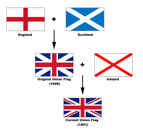
Diagram of the component flags of the UK's Union Jack flag, including the flags of Scotland, England, and Ireland. The UK will likely have to change its flag if Scotland becomes independent.
Development of the UK’s flag (source)

An independent Scotland could keep its current name and flag – ironically, it would be the UK that might have to change. The current full name of the UK is the “United Kingdom of Great Britain and Northern Ireland”, and without Scotland it would only have control over two-thirds of Great Britain.

But even if the UK decides to let that one fly, it will probably still have to change its iconic “Union Jack” flag. The blue background and diagonal white bars of that flag are actually the flag of Scotland, a design known as the St. Andrew’s Cross. Flag enthusiasts are already proposing new designs, many making a point of adding a symbol for Wales, which was left out of the current flag because it was considered part of England at the time the banner was designed.

(See also: Other countries that have changed their flags recently

Will Scotland stay in the EU, NATO, and other important organizations?
Not automatically, in most cases. It will have to re-apply as a new member country for most organizations. The United Nations will probably accept an independent Scotland as long as Britain doesn’t object, though Scotland will have to give up the veto power that the UK gets as a member of the UN Security Council. 

The European Union could be more complicated. It’s technically possible for the EU to keep an independent Scotland in the organization without making it reapply, but there’s a hot debate over whether that would really happen. Meanwhile, if Scotland applies anew to the EU, there’s a chance it could face a veto from Spain, which is determined not to let go of its own separatist region, Catalonia. On the other hand, if Scotland votes “no”on Thursday, it could still end up leaving the EU unwillingly – the British government is planning a 2017 referendum on whether the whole UK should leave the European body. Most Scottish people want to stay in the EU, but they could be outnumbered at the polls by euroskeptics to their south.

NATO membership for an independent Scotland is also uncertain. The Scottish National Party’s anti-nuclear policy could mean the end of the UK Trident program, Britain’s only active nuclear weapons system, which is based in Scotland. Though Scotland’s close relationship to other members would seem to make its entry into the alliance a sure thing, and there are many NATO member countries without nuclear weapons, some think NATO would be annoyed with an independent Scotland for essentially disarming another member, the UK.

What about the Olympics and World Cup?
As mentioned earlier, Scotland already has its own FIFA football (soccer) team, but it currently competes in the Olympics as part of Great Britain. Scottish leaders are hopeful that the country can compete independently in the 2016 Olympics in Brazil, but it could be a bit of a rush if it declares independence that same year.

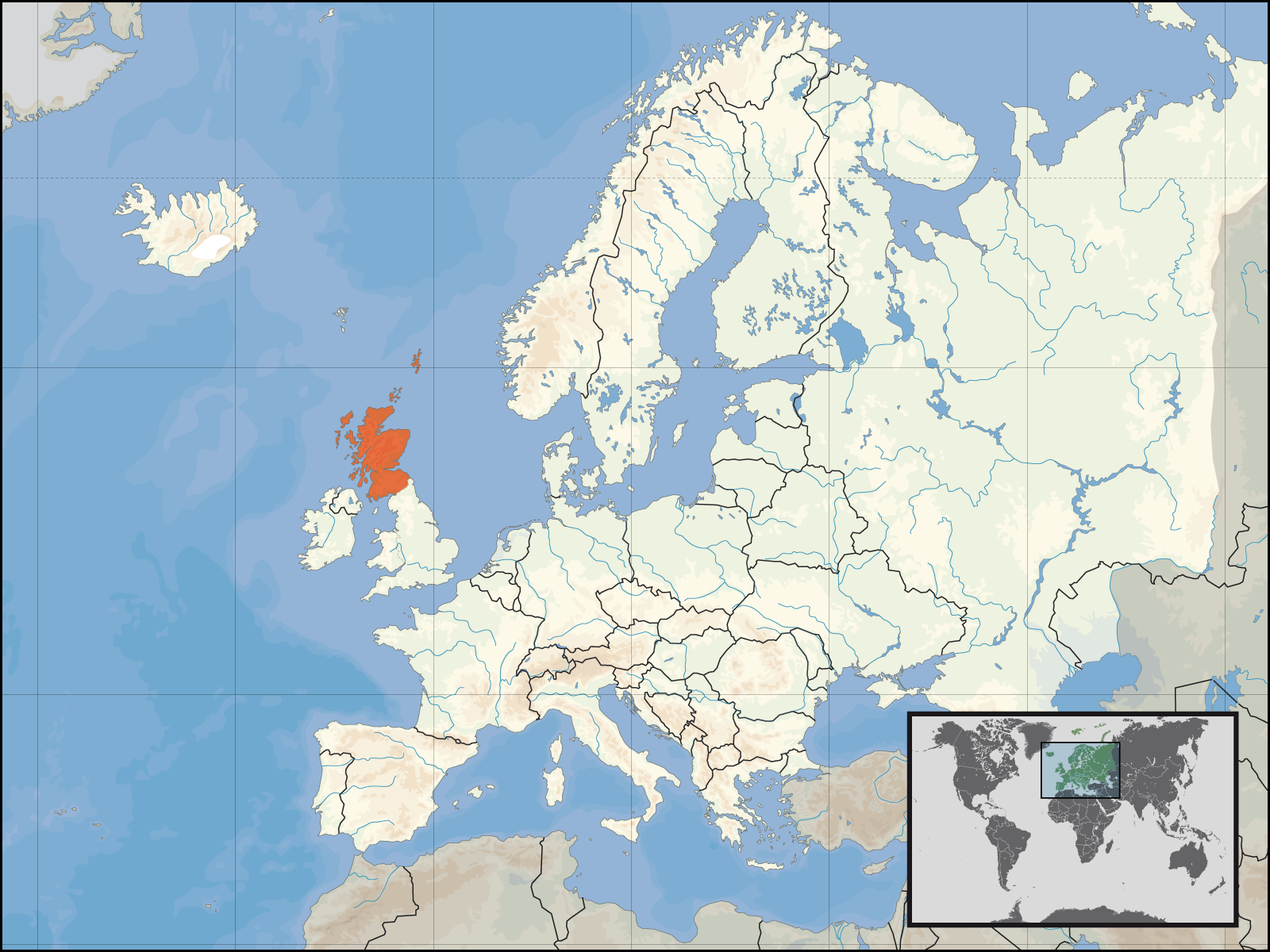
Map of an independent Scotland's location within Europe. On September 18, 2014, Scotland will vote on whether to leave the UK to become an independent country.
Scotland’s location with Europe
Map by Rab-k and David Liuzzo (source)

First, an independent Scotland would first have to prove it’s a real country by joining the UN. Probably not a big problem; in 2011, South Sudan achieved this within days of independence. But a bigger problem might be the time it takes to organize a national Olympic committee – something South Sudan still has yet to do. If Scotland doesn’t get its stuff together quick, Scottish athletes will have to compete under the UK flag one more time. (See also: Which Countries Are (and Aren’t) in the Olympics?)

But can the queen stay?
Scotland’s leader, Alex Salmond, says the independent Scotland would keep Queen Elizabeth II as its monarch, making her Queen of Scotland just as she’s also the Queen of the United Kingdom and 15 other independent countries. However, it may not be up to him: some political forces in Scotland are pushing for a separate referendum on whether to keep the queen or abolish the monarchy and become a republic.

Will all of Scotland go along with independence?
Probably, but that wasn’t always a given. Three island groups along Scotland’s fringes – Orkney, Shetland, and the Outer Hebrides – have been less enthusiastic about independence than many other parts of the country. Earlier this year, a group of islanders tried to organize a second referendum that would allow the island groups to declare their own independence or rejoin the UK if Scotland splits. That plan doesn’t seem to have caught on, but the islands’ local governments have taken advantage of the controversy to secure extra autonomy (self-rule) regardless of whether Scotland leaves the UK or not.

So, what will happen to Scotland if it votes “no”?
If the referendum fails, Scotland will stay part of the UK, probably for a long time to come, since the results will be seen as a popular rejection of separation. But that doesn’t mean nothing will change. In a bid to dissuade Scottish voters from independence, British political leaders have made strong promises that if Scotland stays in the UK, it will get much greater powers of self-government within Britain than it has now. These would include greater control over its finances, taxation, and possibly welfare, big issues in a region that usually votes for the left-of-center Labour Party, yet often finds itself stuck in a Britain ruled by the opposing Conservatives.

What will happen next? Stay tuned to PolGeoNow for more updates on Scottish independence!

Syria Civil War Map: September 2014 (#14) (Premium)

There are newer versions of this map available. To see them, view all Syria updates.

Detailed map of fighting and territorial control in Syria's Civil War (Free Syrian Army and Nusra Front rebels, Kurdish groups, ISIS/ISIL/Islamic State and others), updated to September 2014.

Download PDF
buy

(Subscribe via Paypal to view all premium content online)

Our Syrian Civil War coverage continues with this updated situation map, showing changes to territorial control since our previous Syria map report in August. Government forces, the Islamic State (ISIS), and the allied rebels have all made territorial gains during the past weeks.

This map and article are exclusive premium content, available to paid subscribers or for individual purchase.
Buy now (US$9.99)

Premium map includes:

  • Up-to-date map of current territorial control in Syria, color-coded for the Assad government, rebel groups, Islamic State (ISIS) extremists, and Kurdish self-protection forces
  • Detailed indication of city-by-city control, highlighting key towns relevant to current events
  • Recent areas of fighting including Tabqa Airbase, Halfaya, Quneitra Province and more
  • Timeline of events since mid-August, including both territorial changes and major political happenings

MEMBERS CLICK HERE TO PROCEED TO ARTICLE AND MAP

NOT A MEMBER YET? SUBSCRIBE NOW!

Ukraine War Rebel Control Map: September 2014 (Premium)

There are newer versions of this map available. To see them, view all Ukraine updates.

Detailed map of pro-Russian rebel control in Ukraine's eastern provinces of Donetsk and Luhansk, claimed by the breakaway Donetsk People's Republic and Lugansk People's Republic. Updated to September 1, 2014

Download PDF
buy

(Subscribe via Paypal to access all premium content online)

Russia is now being accused of directly invading eastern Ukraine, and opposition control in the region has seen major changes since our last Ukraine war map update.

This is detailed map and timeline of pro-Russian territorial control in eastern Ukraine’s Donetsk and Luhansk regions, home to the claimed Donetsk People’s Republic, Lugansk People’s Republic, and Federation of Novorossiya. Updated to the start of September 2014.

This map report is exclusive premium content, available to paid subscribers or for individual purchase.
Buy now (US$9.99)

Premium map includes:

  • Detailed, updated map of Donetsk and Luhansk regions, showing both past and current rebel control
  • Indication of which districts and cities have had their administrations occupied by separatists
  • Timeline of changes to territorial control since July, and summary of major trends

MEMBERS CLICK HERE TO PROCEED TO ARTICLE AND MAP

NOT A MEMBER YET? SUBSCRIBE NOW!