Taiwan Loses “Recognition” from El Salvador (Map)

You can always find the latest version of this map, and a list of all related articles, on our Which Countries Recognize Taiwan? page.

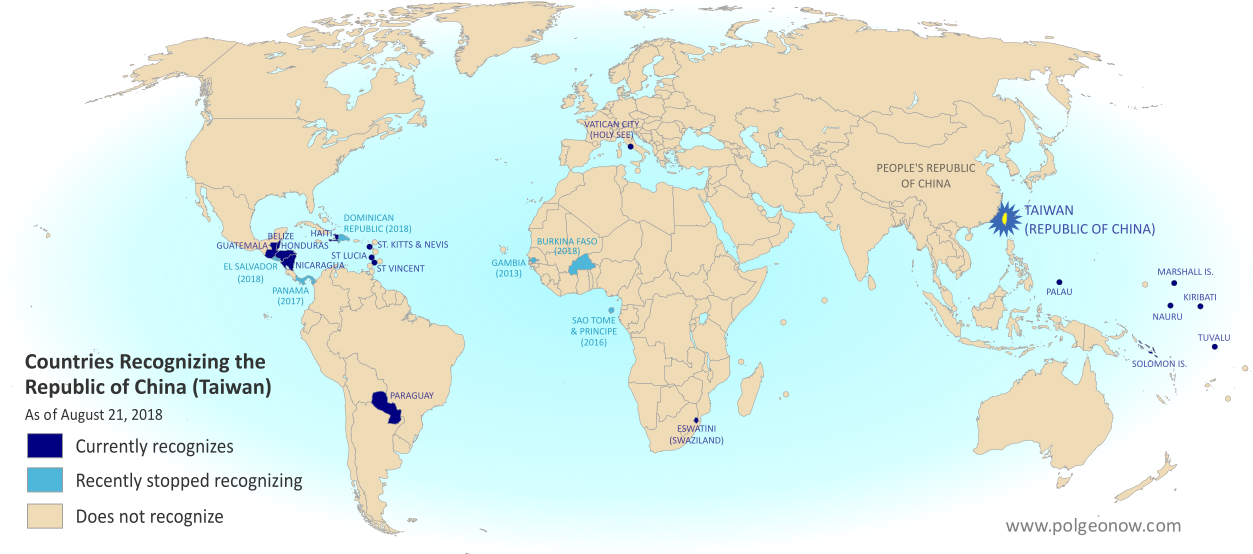
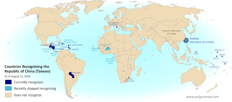
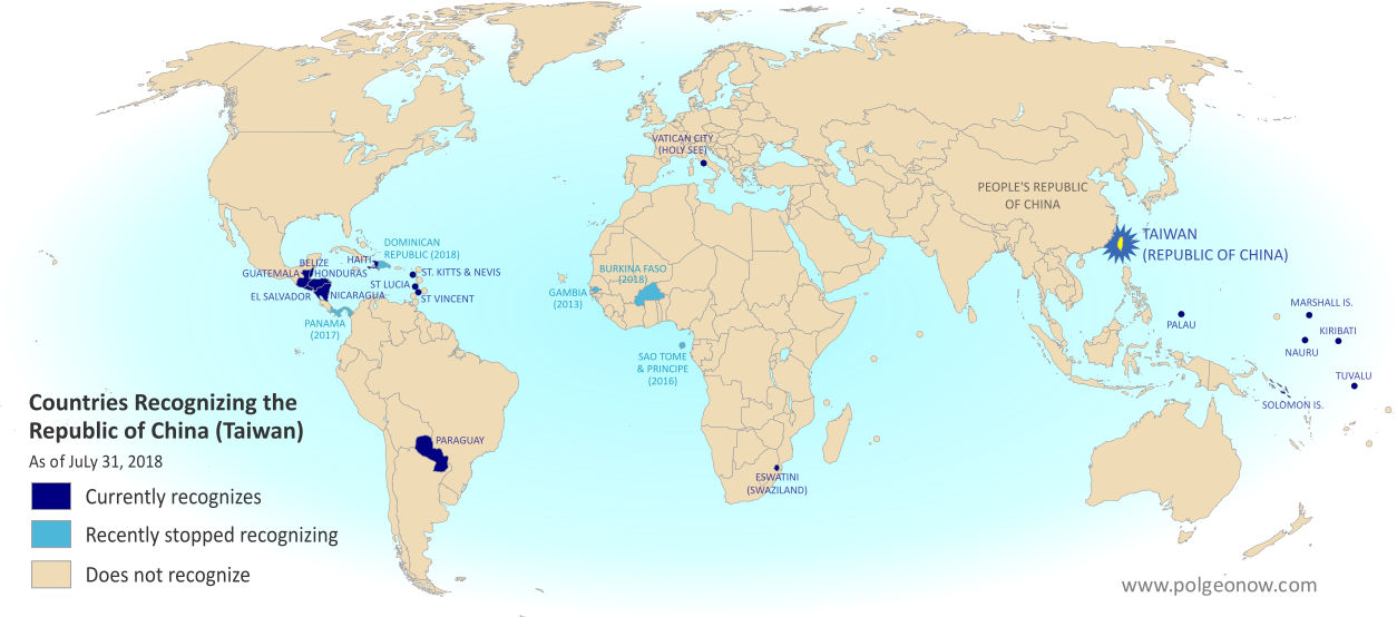
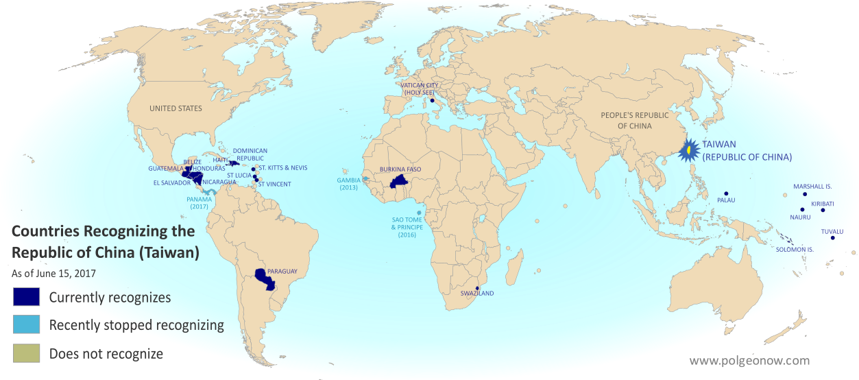
Map of who recognizes Taiwan (what countries recognize the Republic of China) in August 2018. Marks countries that have cut diplomatic ties with Taiwan (withdrawn recognition) in the last ten years: El Salvador, Burkina Faso, the Dominican Republic, Panama, Sao Tome and Principe, and the Gambia. Also answers question: Where is Republic of China located? (Colorblind accessible)
Click to enlarge. By Evan Centanni, modified from public domain blank world map.
Contact us for permission to use this map.

Article by Evan Centanni

El Salvador Drops Taiwan

Flag of the Republic of China (Taiwan) Short Name (informal):  
• Taiwan (English)
• ROC (English)
• Táiwān (Chinese)
Official Name (in constitution):  
• Republic of China (English)
• Zhōnghuá Mínguó (Chinese)
Other names used officially:  
• “Republic of China (Taiwan)” (government offices)
• Chinese Taipei (international sports)
• Taiwan, Province of China (used by UN without Taiwan’s input)   
Capital: 
Taipei (de facto)
Claimed by: People’s Republic of China 

Disputed Taiwan lost its official endorsement from the Republic of El Salvador today. The small but densely-populated Central American country is cutting ties with Taiwan’s government in favor of setting up relations with Mainland China, becoming the latest to endorse the Mainland’s claim that Taiwan is part of China.

In a novel twist, reports said Taiwan’s government “pre-emptively” cut ties with El Salvador just hours before the Salvadoran government publicly announced the switch. But the move was still based on a decision by El Salvador, which Taiwan officials said had been holding talks on the possibility since June.

Is Taiwan a Country?

The islands of Taiwan operate like an independent country today, but are governed under the constitution of the “Republic of China” (ROC), the government that ruled Mainland China before the country’s communist revolution (the administration that now rules the Mainland is called the People’s Republic of China, or PRC).

Since 1991, Taiwan’s government has sought recognition separate from Mainland China in the UN, without challenging the PRC’s right to the Mainland. But because the Mainland government insists Taiwan can’t be separate, it cuts ties with any countries that set up relations with Taiwan, even if they want to stay friends with China too.

“Economic Reasons”

El Salvador’s government is calling its shift away from Taiwan the only reasonable choice in a world where China is one of the most powerful economies, saying that it will bring more opportunities in the future. El Salvador has never before had diplomatic relations with the PRC. Alluding to the fact that the ROC no longer governs most of China, a Salvadoran spokesman was quoted as saying, “El Salvador can’t turn its back on international reality.”

Taiwan’s government, on the other hand, described more specific motivations. The disputed country’s foreign minister accused El Salvador’s president of asking Taiwan to fund his re-election campaign, and said the Salvadoran government had also backing for an expensive port construction project that would have left both countries in debt. (Some speculate that if China steps in to fund the port, it could eventually host the first Chinese military base in the Americas.)

Though Taiwan’s dwindling list of diplomatic contacts may not be a critical threat to its self-governing status, these changes are not merely symbolic. Even aside form the economic ramifications for El Salvador, many average people on both sides may be affected. For example, Salvadoran students in Taiwan are about to see their studies cut short, being forced to either transfer to Mainland China or return home.

Learn More: What Exactly is Taiwan, and Do Countries Really “Recognize” It?

Republic of China: Shrinking Recognition

Today, only 17 countries in the world (about 9%) still have formal diplomatic relations with the Taiwan-based “Republic of China” government – the closest equivalent to officially “recognizing” Taiwan as a country. That includes 16 United Nations (UN) member countries plus UN observer state Vatican City.

El Salvador is the fifth country to drop Taiwan since the current ROC president, whose platform involves resisting Mainland Chinese influence, took office in 2016. Before El Salvador, the last four countries to switch to China were the Dominican Republic and Burkina Faso this May, Panama in June 2017, and São Tomé and Príncipe in December 2016.

Only one country, the Gambia, abandoned Taiwan between 2008 and 2016, during a “diplomatic truce” initiated by Taiwan’s most Mainland-friendly president (even then, the PRC waited until Taiwan elected its current president before restoring its own relations with the Gambia).

Graphic of the Republic of China (Taiwan) flag is in the public domain (source).

Map: Which Countries “Recognize” Taiwan?

This map and explainer will be updated whenever there’s a change to the list of Taiwan’s “diplomatic allies”. You can find articles on each change by scrolling to the bottom of this page, or by viewing all Taiwan articles on PolGeoNow.

Map of who recognizes Taiwan (what countries recognize the Republic of China) in August 2018. Marks countries that have cut diplomatic ties with Taiwan (withdrawn recognition) in the last ten years: El Salvador, Burkina Faso, the Dominican Republic, Panama, Sao Tome and Principe, and the Gambia. Also answers question: Where is Republic of China located? (Colorblind accessible)
Click to enlarge. By Evan Centanni, modified from public domain blank world map.
Contact us for permission to use this map.

Is Taiwan a Country?

At PolGeoNow we frequently report on self-proclaimed, unrecognized or partially-recognized countries – but Taiwan is a special case. It operates like an independent country today, but has never formally declared independence. Instead, Taiwan and its surrounding islands govern themselves as the “Republic of China” (ROC), under a constitution brought there by a former government of the Chinese mainland.

Flag of the Republic of China (Taiwan) Short Name (informal):  
• Taiwan (English)
• ROC (English)
• Táiwān (Chinese)
Official Name (in constitution):  
• Republic of China (English)
• Zhōnghuá Mínguó (Chinese)
Other names used officially:  
• “Republic of China (Taiwan)” (government offices)
• Chinese Taipei (international sports)
• Taiwan, Province of China (used by UN without Taiwan’s input)   
Capital: 
Taipei (de facto)
Claimed by: People’s Republic of China

Taiwan (ROC) vs. Mainland China (PRC)

Taiwan’s ROC government stands in contrast to the People’s Republic of China (PRC), which took the Mainland from the ROC in the Chinese Communist Revolution of the 1940s. The PRC government in Bejing never managed to take over Taiwan, but still insists that it will someday, saying the island is an inseparable part of China. It maintains delicate, semi-official relations with the ROC government in Taipei, but fiercely opposes any move toward formal Taiwanese independence.

Taiwan’s ROC government also claimed ownership of all China at one time, when it was ruled under martial law by Chiang Kai-shek‘s Chinese Nationalist Party (Kuomintang, or KMT). But with democracy now in place, and fewer and fewer Taiwanese people thinking of themselves as Chinese, recent administrations have backed off from those claims.

In fact, many of Taiwan’s politicians support increased acknowledgement of independence, but so far no administration has been willing to risk war with Mainland China by issuing a full-on independence declaration.

Who “Recognizes” Taiwan?

Until the 1970s, the Taiwan’s ROC government held onto China’s seat in the United Nations (UN), and was considered China’s rightful government by the majority of the world’s countries. But after the UN General Assembly deposed it and replaced it with the PRC in 1971, the tables turned quickly.

Today, only 17 countries in the world (about 9%) still have formal diplomatic relations with the Taiwan-based ROC government, including 16 UN member countries plus UN observer state Vatican City. All of them are marked on the map above, along with all countries that have cut diplomatic ties with the ROC within the last ten years.
 
Now, recognizing a government doesn’t technically have the same legal meaning as recognizing a country. Officially, everyone recognizes China as a country, but they disagree over whether the ROC or PRC administration is China’s government. That means that when we talk about countries “recognizing” Taiwan, it’s not technically the same thing as when countries recognize Kosovo or Palestine.

To illustrate that point: A country that recognizes Kosovo as a country independent from Serbia normally continues to recognize Serbia as a country too. But in the case of China and Taiwan, countries are forced to pick one or the other. Because the Mainland government insists Taiwan can’t be separate, it cuts ties with any countries that set up relations with Taiwan, even if they want to stay friends with China too.

Still, saying that a country with diplomatic ties to the ROC “recognizes Taiwan” is a useful practical analogy, since Taiwan now strives to be something more like a self-declared country than a rival government of China. In fact, after 1991 Taiwan’s government requested a seat separate from Mainland China in the UN, accepting the PRC’s right to rule the Mainland even while making sure not to declare outright independence.

North and South Korea have an arrangement just like that, both technically claiming to be governments of Korea while still allowing each other to have separate recognition and UN seats. But because the PRC sees Taiwan its subordinate, not its equal, it has blocked any similar deal from happening.

Taiwan Recognition News on PolGeoNow

Since 2017, PolGeoNow has been bringing you ongoing coverage of all events effecting the recognition of Taiwan. News articles about these changes are listed here:

Map of who recognizes Taiwan (what countries recognize the Republic of China) in August 2018. Marks countries that have cut diplomatic ties with Taiwan (withdrawn recognition) in the last ten years: El Salvador, Burkina Faso, the Dominican Republic, Panama, Sao Tome and Principe, and the Gambia. Also answers question: Where is Republic of China located? (Colorblind accessible)El Salvador Switches Recognition from Taiwan to China
Taiwan and El Salvador cut ties in August 2018, amid accusations of unreasonable Salvadoran financial demands.

Full map and article

Map of who recognizes Taiwan (what countries recognize the Republic of China) in June 2018. Marks countries that have cut diplomatic ties with Taiwan (withdrawn recognition) in the last ten years: Burkina Faso, the Dominican Republic, Panama, Sao Tome and Principe, and the Gambia. Also answers question: Where is Republic of China located? (Colorblind accessible)Taiwan Loses Dominican Republic, Burkina Faso Recognition
In May 2018, two more countries cut ties with Taiwan in favor of relations with Mainland China, both under financial pressure.

Full map and article

Map of who recognizes Taiwan (what countries recognize the Republic of China) in June 2017. Marks countries that have cut diplomatic ties with Taiwan (withdrawn recognition) in the last ten years: Panama, Sao Tome and Principe, and the Gambia. Also answers question: Where is Republic of China located? (Colorblind accessible)Panama Recognizes China, Stops Recognizing Taiwan
In 2017, the Central American republic of Panama became the second country to cut ties with Taiwan since an eight-year “diplomatic truce” between the ROC and PRC ended in 2016.

Full map and article


Graphic of the Commonwealth flag is displayed under fair use principles (source).

Taiwan Loses Recognition from Dominican Republic, Burkina Faso (Map)

You can always find the latest version of this map, and a list of all related articles, on our Which Countries Recognize Taiwan? page.

Map of who recognizes Taiwan (what countries recognize the Republic of China) in July 2018. Marks countries that have cut diplomatic ties with Taiwan (withdrawn recognition) in the last ten years: Burkina Faso, the Dominican Republic, Panama, Sao Tome and Principe, and the Gambia. Also answers question: Where is Republic of China located? (Colorblind accessible)
Click to enlarge. By Evan Centanni, modified from public domain blank world map.

Article by Evan Centanni

Dominican Republic, Burkina Faso Drop Taiwan

Flag of the Republic of China (Taiwan) Short Name (informal):  
• Taiwan (English)
• ROC (English)
• Táiwān (Chinese)
Official Name (in constitution):  
• Republic of China (English)
• Zhōnghuá Mínguó (Chinese)
Other names used officially:  
• “Republic of China (Taiwan)” (government offices)
• Chinese Taipei (international sports)
• Taiwan, Province of China (used by UN without Taiwan’s input)   
Capital: 
Taipei (de facto)
Claimed by: People’s Republic of China 

This past May, disputed Taiwan lost its official endorsements from both the Dominican Republic in the Caribbean, and Burkina Faso in West Africa. The two countries have cut ties with Taiwan in favor of setting up official relations with Mainland China, endorsing the Mainland’s claim that Taiwan is part of China.

The islands of Taiwan operate like an independent country today, but are governed under the constitution of the “Republic of China” (ROC), the government that ruled Mainland China before the country’s communist revolution (the administration that now rules the Mainland is called the People’s Republic of China, or PRC).

Since 1991, Taiwan’s government has sought recognition separate from Mainland China in the UN, without challenging the PRC’s right to the Mainland. But because the Mainland government insists Taiwan can’t be separate, it cuts ties with any countries that set up relations with Taiwan, even if they want to stay friends with China too.

The Dominican Republic announced it was cutting ties with Taiwan on May 1, 2018, saying the reason was “history and socioeconomic reality”. This reality allegedly includes the equivalent of $3.1 billion US dollars in investments and loans from China, though the Dominican government only mentioned future tourism opportunities as an example.

Burkina Faso followed on May 24, even though it had just co-sponsored Taiwan’s bid to become an observer at World Health Organization (WHO) meetings. The Burkinabe government also cited “socio-economic challenges” and the “evolution of the world” as the reasons for its switch.

Learn More: What Exactly is Taiwan, and Do Countries Really “Recognize” It?

Republic of China: Shrinking Recognition

Today, only 18 countries in the world (about 9%) still have formal diplomatic relations with the Taiwan-based “Republic of China” government – the closest equivalent to officially “recognizing” Taiwan as a country. Before the Dominican Republic and Burkina Faso cut ties in May, the last two countries to drop Taiwan in favor of the PRC were Panama in June 2017 and São Tomé and Príncipe in December 2016.

Only one country, the Gambia, abandoned Taiwan between 2008 and 2016, during a “diplomatic truce” initiated by Taiwan’s most Mainland-friendly president (even then, the PRC waited until Taiwan elected a more independence-leaning president before restoring its own relations with the Gambia).

Taiwan’s last remaining “diplomatic ally” in Africa is tiny Eswatini (Swaziland), whose king recently promised not to follow Burkina Faso in switching to the PRC. Supporters of a separate Taiwan worry their next loss might be the Holy See, government of the Catholic Church’s independent Vatican City in Rome. The Vatican has recently been working to patch up its bad relationship with the Mainland Chinese government.

Learn More: What’s the difference between Vatican City and the Holy See?

Graphic of the Republic of China (Taiwan) flag is in the public domain (source).

Map: Costa Rica & Nicaragua Settle Border Dispute in Court

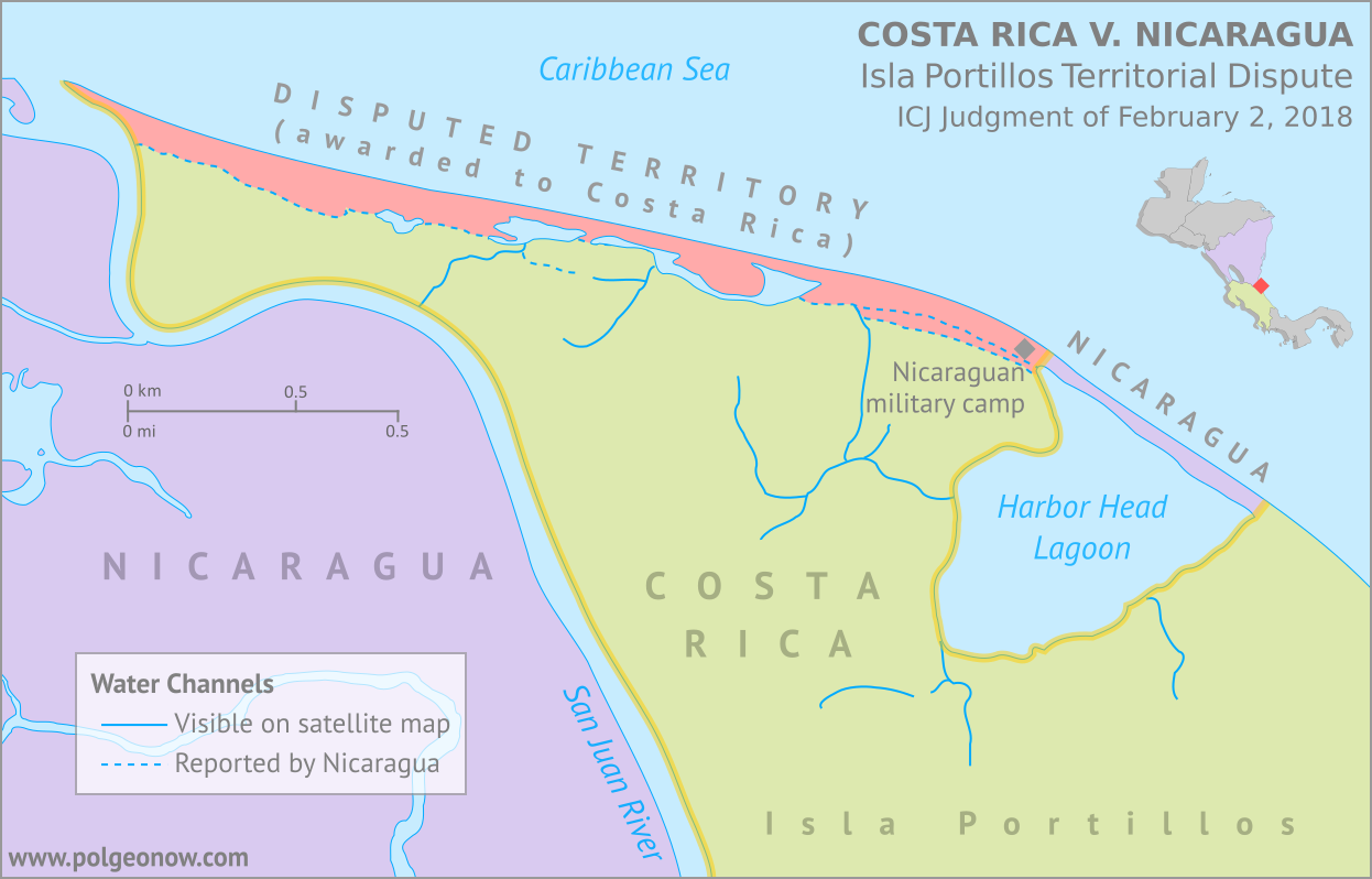
Conflicto Isla Portillos - mapa 2018. Map of Costa Rica and Nicaragua's post-2015 territorial dispute on Isla Portillos at the mouth of Rio San Juan, showing the judgment of the International Court of Justic (ICJ) of February 2018, based on the case filed in 2017. Includes key features such as Harbor Head Lagoon, the Nicaraguan military camp, the disputed territory along the beach, and the small water channels used to argue Nicaragua's case. Colorblind accessible.
Map by Evan Centanni, based on materials submitted to the court. Contact for usage permissions.

World Court Rules on Costa Rica vs. Nicaragua

What happens when two countries draw their border along a river, then the river changes course? The world got to find out yesterday, as the UN’s International Court of Justice (ICJ) released its judgement on a border dispute between Nicaragua and Costa Rica. Though the court’s ruling was dominated by a related request to define the two countries’ borders at sea, it also involved a tiny sliver of land in a temperamental river delta.

The Isla Portillos Dispute

The disputed land territory involves a slice of coastline at the northern tip of Isla Portillos, an island located in the delta of the River San Juan de Nicaragua (Isla Portillos is sometimes considered part of the larger Calero Island). The border once ran along the river and into a lagoon before hitting the Caribbean Sea, but a hundred years of natural changes to the area’s geography messed that all up.

In this court case – the latest of several between the two countries – Nicaragua claimed that a tiny channel of water still connected the river to the lagoon, separating a narrow strip of Nicaraguan coastline from the island’s Costa Rican interior. But Costa Rica argued that the channel, if it even existed, had been artificially built by Nicaragua, and that the Nicaraguan sandbar that once did exist had long ago eroded away. In this view, a small Nicaraguan military camp on the beach – recently moved from the mouth of the lagoon to a spot slightly farther west – was an illegal occupation of Costa Rican territory.

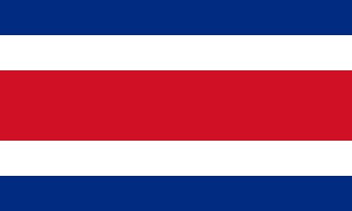
Flag of Costa Rica (civil)Country Name:  
• Costa Rica (English, Spanish)
Official Name:  
• Republic of Costa Rica (English)
• República de Costa Rica (Spanish)
Capital: San José

Costa Rica admitted that the lagoon itself, and the piece of beach now separating it from the sea, still belonged to Nicaragua, leaving a tiny piece of Nicaraguan territory separated from the rest of the country. Even so, Costa Rica warned that Nicaragua might even lose all of that if the beach erodes away completely (international law doesn’t normally allow a country to claim a body of water without owning some piece of land next to it).

Judgement Day: Who Owns the Beach on Isla Portillos?

When it released its decision this yesterday, the ICJ agreed with Nicaragua that the status of the disputed territory hadn’t already been decided by earlier court rulings. But in the end the judges sided almost entirely with Costa Rica, agreeing that the beach between the lagoon and the mouth of the river are Costa Rican. In a decision made by a vote of fourteen to two, Nicaragua was left with just the lagoon and its short strip of beach, and was ordered to move the military camp off of Costa Rican land.

In an unusual move, the court also decided that the sea just outside of the lagoon would be Costa Rican waters. Normally, any coastline controlled by a country automatically gives it the rights to at least some of the neighboring waters, and denying that to Nicaragua might turn out to be controversial.

The Story of a Border Dispute

The tale of the Isla Portillos dispute goes back almost 200 years, involving a US president, a Confederate general, and a lot of creative geographical analysis.

Costa Rica and Nicaragua declared independence from Spain together in 1821, and went their separate ways after the Federal Republic of Central America fell apart in 1838. But from early on, they scuffled over exactly which land belonged to which country. In 1858, they set out to end the disputes by precisely defining the course of their border in the Cañas–Jerez Treaty of Limits.

That treaty set the right bank of the San Juan River as the border in the Caribbean coastal area, with the boundary ending at a spot called Punta Castilla by the river’s mouth. After bringing in US President Grover Cleveland as a mediator from 1886 to 1888 to settle remaining disputes over the treaty’s validity, plus the exact location of Punta Castilla, the border seemed to be settled once and for all.

>Only one problem: Rivers change course over time. By 1896, when the Costa Rican and Nicaraguan governments set out to actually mark their border with pillars on the ground, the end of the San Juan River had split into three separate channels, hitting the ocean kilometers apart from each other. Naturally, each country chose whichever border interpretation gave it the most land, leaving the intervening islands disputed once again.

Map of the border between Nicaragua and Costa Rica at the Caribbean mouth of the San Juan River as decided by the 1897 Alexander award, including prior claims by each country. Includes Harbor Head Lagoon, the Taura Branch of the San Juan River, and the island now known as Isla Portillos.
Click to enlarge: Map of General Alexander’s 1897 border decision, and the Nicaraguan and Costa Rican claims of the time. The largest island, cut off by the Taura Branch, is Isla Portillos. Public domain illustration (source).

Still, it was no surprise that some disputes would come up in the process of marking out the border, and that’s why they had another third-party mediator on hand.

Grover Cleveland – US president again after a break from 1888-1893 – couldn’t participate in person, so instead he sent his friend Edward Porter Alexander, an engineer and former Confederate general from the US Civil War.

General Alexander decided the border should run as close as possible to the original Punta Castilla spot, now located at the northeastern corner of Harbor Head Lagoon on the San Juan’s middle channel. Realizing the river’s course would keep changing in the future, Alexander specified that the future border should always follow the east side of the lagoon and then continue up “the first channel met” into the San Juan River proper.

The Dispute Enters the 21st Century

Alexander’s solution continued to work for about a century. But over the decades Punta Castilla was swallowed by the sea (its original location now lies about a kilometer straight out to sea from the edge of the lagoon), and by the 2000s, another problem had come up: Harbor Head Lagoon wasn’t connected to the San Juan River at all anymore. Or was it?

Nicaragua claimed it had found a tiny channel through the forest connecting the lagoon to the river even more directly than before (“the first channel met”, remember?). This left the whole northern tip of Isla Portillos, roughly from the lagoon westward, as the supposed territory of Nicaragua. The dispute came to a head in 2010, when a Nicaraguan military commander infamously used Google Maps to argue that his troops had the right to land on Isla Portillos and begin dredging operations there.

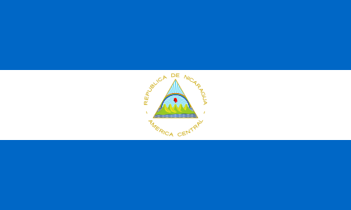
Flag of NicaraguaCountry Name:  
• Nicaragua (English, Spanish)
Official Name:  
• Republic of Nicaragua (English)
• República de Nicaragua (Spanish)
Capital: Managua

Costa Rica took Nicaragua to court at the ICJ over its actions, and in 2015 the judges agreed with Costa Rica: The newly-claimed channel wouldn’t fly, and the Nicaraguan troops would have to leave. Costa Rica took this to mean the entire island was Costa Rican, except for the lagoon, which was directly mentioned in the border treaty, and the strip of beach that now separated the lagoon from the sea. But the court made a point of not drawing exact borders, and took a pass on saying who owned the island’s narrow coastal strip.

Back to Court: The 2017-2018 Dispute

Soon, Nicaragua began arguing that a tiny piece of the original river channel still ran just behind the beach, connecting the lagoon to the present river mouth. Costa Rica insisted the strip of Nicaraguan land north of the channel had long ago eroded into the sea, and there was only a “channel” remaining behind the beach if Nicaragua had dug a new one farther back.

In 2017, Costa Rica took Nicaragua back to court over the disputed strip of coastline, and yesterday the judges again took the side of Costa Rica, by a vote of fourteen to two. They concluded that there is no more channel, and that the whole beach is Costa Rican except for the part directly between the lagoon and the Caribbean Sea – now a tiny enclave of Nicaraguan territory separated from the rest of the country.

So the dispute is resolved again, for now. But one thing’s for sure: We haven’t seen the end of changes to the area’s riverbanks and coastlines. It’s probably just a matter of time before a new variation of this centuries-old territorial dispute pops back up. Judge Awn Al-Khasawneh, who voted against awarding the land to Costa Rica, and felt the court should have come up with a more permanent solution, quoted medieval Persian poet Hafez of Shiraz in his dissenting opinion: 

“The house of hope is built on sand…”

Need ALL the details? You can find complete documentation of the court case on the ICJ website: records for the Isla Portillos case here, with the judgement and related documents here.

All About Nagorno-Karabakh’s 2017 Name Change

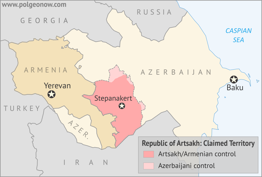
Map of the self declared Republic of Artsakh (Nagorno-Karabakh Republic) in relation to Armenia and Azerbaijan. Includes capital cities Yerevan, Baku, and Stepanakert.
Map by Evan Centanni, modified from this map by Bourrichon and Lesqual. License: CC BY-SA

Nagorno-Karabakh is Now “Artsakh”

Most country name changes are just modifications to the country’s official long name, or a switch in the name’s preferred English translation. But last year, one self-proclaimed country changed its title completely.

In February 2017, the disputed Nagorno-Karabakh Republic officially became the “Republic of Artsakh“. The name switch was part of a new constitution, approved in an internationally-controversial Feb. 20 referendum. According to the breakaway government’s official figures, the referendum passed by 88%, with a voter turnout of 76%.

What is Nagorno-Karabakh/Artsakh?

The status of the so-called Republic of Artsakh is a matter of hot dispute. According to the UN and all its member countries, Nagorno-Karabakh was never officially a country at all. The region is claimed by Azerbaijan and labeled a disputed territory by the international community, but it declared independence during the breakup of the Soviet Union, and has been ruled separately from Azerbaijan since the early 1990s.

In terms of military defense and day-to-day administration, Artsakh is heavily integrated with neighboring Armenia (most people living there are culturally Armenian). But the region’s government officially considers itself an independent country, and Armenia maintains a formal separation, neither recognizing Artsakh’s independence nor making it officially part of Armenia.

The only formal recognition of Artsakh’s independence comes from three other unrecognized, self-proclaimed countries – Abkhazia, South Ossetia, and Transnistria – plus a long list of local governments inside the US who have made symbolic declarations of support (presumably at the urging of that country’s Armenian political lobby).

Nagorno-Karabakh and Artsakh: Both Names Accepted

The name “Republic of Artsakh” didn’t come out of nowhere – in fact, it was already an official alternate name for the claimed country. The new constitution basically just switches the two names’ places:

Before After
Main Name in Constitution Nagorno-Karabakh Republic Republic of Artsakh
Official Alternate Name Artsakh Republic Republic of Nagorno-Karabakh

The old constitution declares that the two names are “the same”, and the new one similarly states that both official titles “are identical”. “Artsakh Republic” is also still in use by some official sources, probably as an alternate English translation. Minor spelling variants seen in government sources include “Nagorno Karabakh” (without the hyphen) and “Nagorno Karabagh”.

What Does “Artsakh” Mean, and Why Choose it Over “Nagorno-Karabakh”?

“Artsakh” is probably easier to remember and pronounce for most people, but the change is also related to the history of the two names. “Nagorno-Karabakh” is actually the Russian name of the region, from when it was part of the Soviet Union, but the “Karabakh” part is based on its name in the Azerbaijani language (likely coming from ancient words meaning “Black Garden“). 

The territory now being disputed is the highland area of the historic Karabakh region, with the Russian word “nagorno” (or “nagorny”) added on signify that. In other words, “Nagorno-Karabakh” means “Upper Karabakh” in Russian.

“Artsakh”, on the other hand, is a thoroughly Armenian name for the territory. Though the actual origin of the word has been lost to history, it was the undisputed name of an Armenian province that occupied the area from ancient times into the Middle Ages. Given that, it’s no surprise that this name is preferred by the Armenia-oriented government of the disputed republic, or by its culturally Armenian majority population.

Flag of the autonomous community of Catalonia Short Name:  
• Artsakh (English, Armenian)
• Dağlıq Qarabağ (Azerbaijani)
Alternate Short Name:
• Nagorno-Karabakh (English)
• Lerrnayin Gharabagh (Armenian)
Full Declared Name:
• Republic of Artsakh (English)
• Artsakhi Hanrapetut’yun (Armenian)
Alternate Full Name:
• Nagorno-Karabakh Republic (English)
• Lernayin Gharabaghi Hanrapetut’yun (Armenian)
Capital: Stepanakert
Status According to Azerbaijan: Armenia-occupied area of Azerbaijan

When Did The Name Change Officially Happen?

When a fully-recognized country, like the Czech Republic, changes its name, it’s fairly simple to the confirm that the change has gone into effect: It soon gets registered in UN databases and the ISO standard list of country codes and names. But for a disputed breakaway region like Artsakh, there’s no such official international documentation.

As with Malawi’s 2012 flag change, we at PolGeoNow were unsure at first if the change had officially come into effect yet – part of the reason we haven’t published an article until now. News outlets reported on Nagorno-Karabakh’s Feb. 20 referendum, but none seemed to say when the change would actually become official (at least, not in English).

So we dug a little deeper, learning that the official law authorizing the referendum says:

[The changes will] enter into force from the moment of publishing the drafts in the “Official Bulletin of the Nagorno Karabakh Republic” within five days after announcing the resolution of the Central Commission or the Supreme Court on the results of the the [sic] Referendum.

We couldn’t find the Official Bulletin in English online, but a declaration on the final referendum results from the Central Electoral Commission is dated to February 23. This seems to suggest that the official name change happened within five days of that, by February 28, 2017. Confirming that the new name has been adopted, the official website of the republic’s president is using “Artsakh”, even though some other government websites haven’t yet changed their headers.

PolGeoNow reports on every country name change that happens in the world! To see the full list, view all country name change articles.

Graphic of the flag of the Republic of Artsakh is in the public domain (source).

Explainer: Is Jerusalem the Capital of Israel or Not?

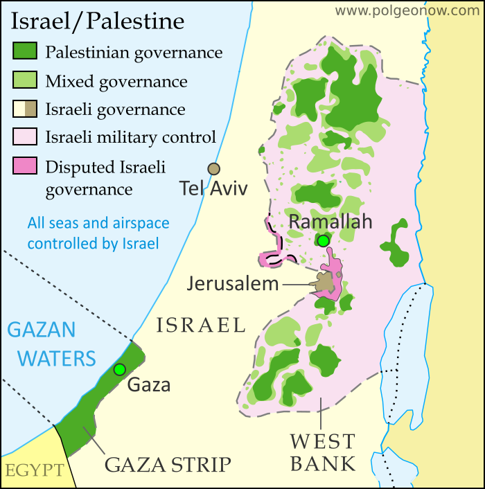
Detailed map of administrative control in Israel and the Palestinian territories (West Bank and Gaza Strip), including official and de facto capitals. Cities: Jerusalem, Ramallah, Gaza, Tel Aviv. Colorblind accessible.
Map by Evan Centanni. All rights reserved.

US recognizes Jerusalem as capital of Israel

This Wednesday, the United States government announced a new policy of recognizing Jerusalem as the capital of Israel. US president Donald Trump said the declaration’s purpose was to “acknowledge the obvious”, while also revealing plans to eventually move the US embassy in Israel to Jerusalem. These decisions were extremely controversial, to say the least. But why? We’ll break it down for you:

So, what’s the big deal?

Israeli law says the city of Jerusalem is the country’s capital. But even Israel’s closest ally, the US, has never officially accepted  the city’s capital status. Almost every other country in the world has done the same: In fact, no country in the world has a proper embassy in Jerusalem. So the new move by the US is a major change of policy, and one that runs contrary to an established world consensus.

But is Jerusalem not the capital of Israel?

A country’s capital is usually, but not always, defined as the city where its government is headquartered. And it’s true that Jerusalem is both the official capital of Israel under the country’s laws, plus the seat of the country’s government, including the legislature, the prime minister, and the Supreme Court. So in that sense Jerusalem is indeed the capital of Israel, for practical purposes at the very least. But that doesn’t mean other countries consider its status legally valid…

So why not recognize Jerusalem as Israel’s capital?

Territory Name:  
• Jerusalem (English)
Yerushalayim (Hebrew)
al-Quds (Arabic)
Claimants: 
• Israel
• Palestine (east Jerusalem only)
Actual Control: Israel
Status: 
• Municipality in Israel (actual governance)
Sub-district in Palestine (claimed; east Jerusalem only)
Part of Jerusalem corpus separatum (claimed by much of international community)

It’s rare for countries to dispute the status of each other’s capitals. The sticking point here is that Arab people in the neighboring West Bank and Gaza Strip territories also claim Jerusalem as the capital of their self-declared State of Palestine.

Just making a competing claim isn’t enough to inspire a worldwide boycott. But the thing is, the United Nations (UN) plan that first endorsed an independent Israel also said Jerusalem should be neutral ground between the Jewish country (now called Israel) and an Arab country (now called Palestine, though “Palestine” was originally a culturally-neutral name for the whole area).

The idea was that Jerusalem and the surrounding area, including the Christian holy city of Bethlehem, would be an internationally-governed neutral zone known as a “corpus separatum” (Latin for “separated body”). But Israel’s 1948-1949 war of independence left western Jerusalem under Israeli control, and since the Six-Day War of 1967, Israel has controlled the whole area. Many think the neutral Jerusalem plan is as good as dead now, but many countries still support it in principile, even treating it as the official legal situation for diplomatic purposes.

Even if they do think neutral Jerusalem is a pipe dream, most countries still support a future where Arabs will get their independent Palestine alongside Israel, and that usually means Jerusalem would at least get divided up between the two countries. In fact, US president Trump made a point of acknowledging that possibility even as he controversially recognized the city as Israel’s capital.

Flag of Israel Country Name:  
• Israel (English)
Yisra’el (Hebrew)
ʼIsrāʼīl (Arabic)
Full Declared Name:  
• State of Israel (English) 
• Medinat Yisra’el (Hebrew)
Dawlat ʼIsrāʼīl (Arabic)
Capital: 
• Jerusalem (functioning but disputed)

Which other countries recognize Jerusalem as Israel’s capital?

It’s difficult to make a full list of countries that recognize Jerusalem’s capital status, because there’s no official register for them to record their positions in. Instead, we’re stuck with looking at what their governments say, and trying to figure out what exactly they mean. 

Maybe the only two countries that seem to unconditionally accept Jerusalem’s role as Israel’s capital are Vanuatu, which reportedly recognized it earlier this year, and disputed Taiwan, which isn’t even recognized as a country itself by most of the world. The Philippines has suggested it might move its embassy to Jerusalem, but doesn’t seem to have made a formal statement of recognition.

Czechia (the Czech Republic) declared the day after Trump’s speech that it recognizes West Jerusalem, but not the whole city, as the capital of Israel. Similarly, Russia’s government has said it thinks East Jerusalem should become Palestine’s capital, and “in this context we view West Jerusalem as the capital of Israel”. This was reported in some media as a recognition, but Russia’s government declared that this week’s US announcement “defies common sense“, so it seems unlikely that’s what they meant.

Other countries have kept their statements vague or neutral, neither recognizing nor rejecting Jerusalem’s claimed capital status.

Then where are all these countries’ embassies, if they’re not in Jerusalem?

Most countries, formerly including the US, don’t recognize any particular city as being the capital of Israel. But all of their embassies are located in the city of Tel Aviv or its suburbs. In the early 1970s, there were 16 countries that did have their embassies in Jerusalem, but most of them left in 1980 after Israel claimed the city’s disputed eastern half as part of its capital. By 2006, there were no more left. 

Even the US embassy is still in Tel Aviv for now, but President Trump says he plans to move it to Jerusalem eventually, maybe after another six months. If he does, it could be the first international embassy to return to Jerusalem, though several more countries might jump on the bandwagon.

Flag of Palestine Claimed Country Name:  
• Palestine (English)
Filasṭīn (Arabic)
Full Declared Name:  
• State of Palestine (English)
• Dawlat Filasṭin (Arabic)
Capital: 
• Jerusalem (claimed; not controlled)
Ramallah (administrative; Fatah faction)
• Gaza City (administrative; Hamas faction)

Most countries’ representative offices to Palestine, on the other hand, are located near the Palestinian government headquarters in the West Bank city of Ramallah, or else in the coastal town of Gaza (ruled by a separate faction of the Palestinian government). In general, these offices aren’t called “embassies” – either because the countries don’t fully recognize Palestine as a country, or because they do recognize it but think the real embassies should be in Jerusalem.

But I thought some countries do have offices in Jerusalem

Yes, they do – ten countries, including the US, have “consulates-general” in Jerusalem. Usually a consulate-general is a regional office that serves under a national embassy, but these are special ones. The consulates-general in Jerusalem are officially representatives to the neutral “corpus separatum” area, not representatives to Israel. 

Because of that, they actually don’t answer to their countries’ embassies in Tel Aviv, instead reporting directly to their national governments. Despite their officially neutral status, most of them also serve as their countries’ representative offices to the Palestinian government in the West Bank.

At least Israel and the Jewish people must be happy about this, right?

Yes and no. Israel’s conservative government enthusiastically supported the US recognition of Jerusalem as its capital, and many Israelis are celebrating. But some think it would have been better to wait until the Israeli-Palestinian conflict is resolved, and others don’t think it should be a big deal. Some of the biggest Jewish groups in the US also approved of the decision, but a big portion also disapproved. Many Palestinians, including Arab Christians, were furious with the symbolic gesture. This may or may not include Arab citizens of Israel, most of whom consider themselves Israelis but disagree with aspects of the country’s governance.

Iraq Control Map & Timeline: Government Takes Kirkuk from Kurdistan – October 2017

There are newer versions of this map available. To see them, view all Iraq updates.
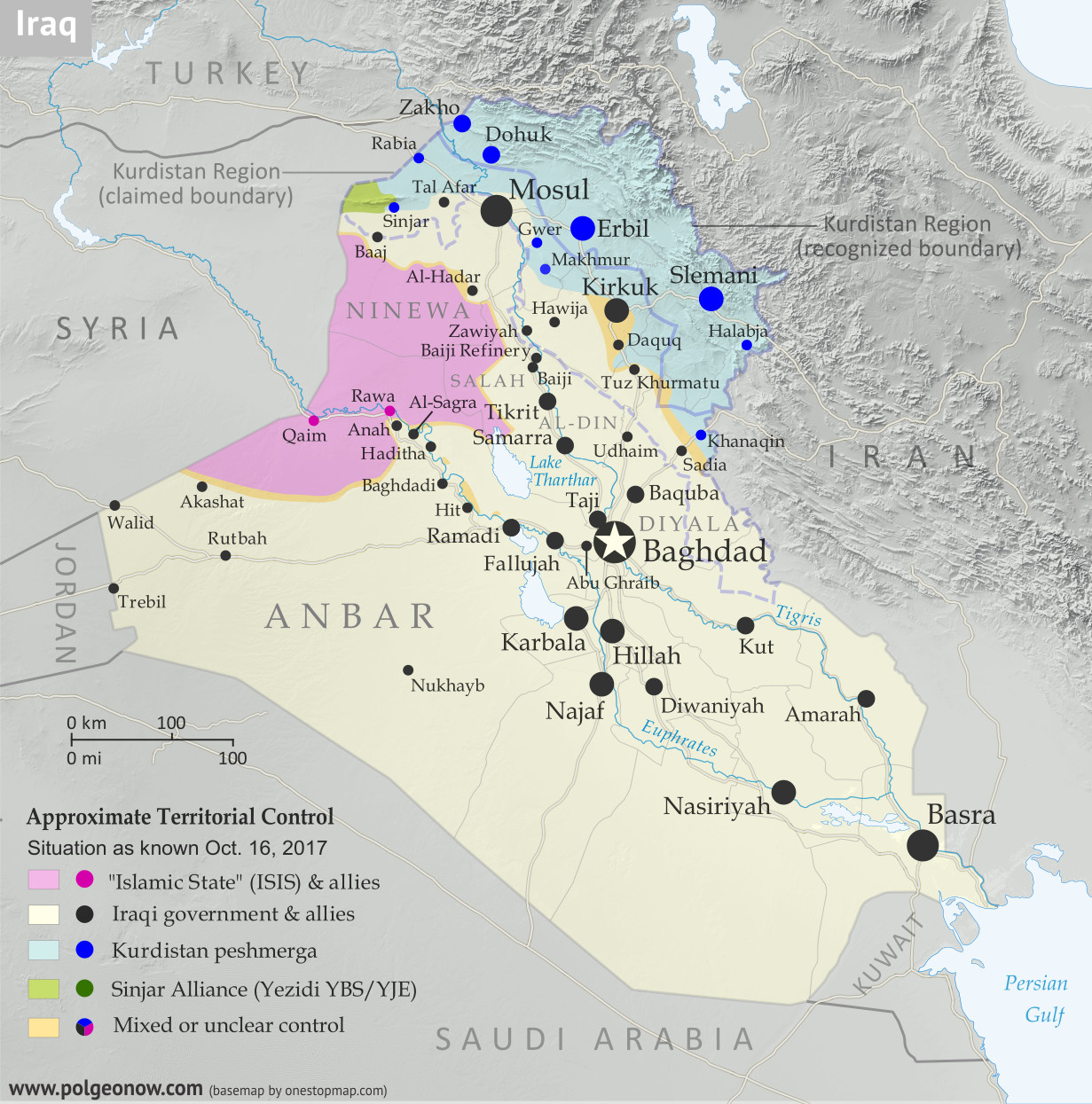
Detailed map of territorial control in Iraq as of October 16, 2017 after the recapture of Hawija and Tal Afar and government seizure of Kirkuk. including territory held by the so-called Islamic State (ISIS, ISIL), the Baghdad government, the Kurdistan Peshmerga, and the Yezidi Sinjar Alliance (YBS and YJE). Colorblind accessible.
Basemap by Koen Adams of onestopmap.com, with territorial control by Evan Centanni and Djordje Djukic. All rights reserved.

(Subscribers click here to view this article in the member area)

Timeline by Djordje Djukic

Summary of Events
Since our previous Iraq control map update in late July, there have been big changes to territorial control in Iraq, all involving expansions of control for the Iraqi military and its close allies (mainly police and Iran-backed militias): The so-called “Islamic State” (IS; formerly ISIS/ISIL) has been driven out of its Tal Afar and Hawija enclaves, and the disputed city of Kirkuk has been retaken from Kurdish forces in response to the controversial Kurdistan independence referendum. Iraqi government forces have also begun to chip away at the remaining swath of IS territory in the countryside of Anbar province, capturing the town of Anah on the road to the Syrian border.

In addition to the elimination of the fully-surrounded IS enclaves in Tal Afar and Hawija, the government recapture of those two areas also means that, for the first time since at least 2014, Iraqi Kurdistan doesn’t share any “borders” with IS territory.

See Also: Syrian Civil War Control Map – September 2017
Flag of IraqCountry Name:  
• Iraq (English, Kurdish)
• al-‘Irāq (Arabic)
Official Name:  
• Republic of Iraq (English)
• Jumhūriyyat al-‘Irāq (Arabic)
Komara Iraqê (Kurdish)
Capital: Baghdad

Timeline of Changes in Territorial Control
The following is an outline of territorial control changes and other major events since PolGeoNow’s previous Iraq map update of July 30, 2017. The abbreviation “IS” refers to the organization calling itself the “Islamic State”, also known as ISIS or ISIL. The Peshmerga are the military forces of self-governed Iraqi Kurdistan.

August 7, 2017
The pro-government Iraqi Shiite militia known as the Popular Mobilization Units (PMU) was attacked by IS close to the border with Syria in the Akashat area. Between 40 and 68 Shiite militiamen were killed in the attack. The militia accused the US-led coalition of hitting its positions with artillery bombardment from across the border. The coalition denied this.

August 15, 2017
The Iraqi military began conducting airstrikes against IS positions in the Tal Afar area, one of two remaining IS-controlled enclaves bordering Kurdistan Peshmerga territory, in preparation for a ground assault.

August 15-17, 2017
A Kurdish delegation to Baghdad refused to postpone Iraqi Kurdistan’s independence referendum, planned for September 25, as it met with Iraq’s Prime Minister and the embassies of the United States, Iran, and Turkey. The next day, the Turkish Foreign Minister and a presidential spokesman voiced strong opposition to the planned referendum, with the minister warning that the move could lead to civil war. On August 17, the Kurdish delegation said Kurdistan could delay the vote on independence “for a short time” if the Iraqi government, under an internationally-backed framework, promised to set another date for the referendum. Later, a senior Kurdish official said the region would consider the possibility of a postponement in return for financial and political concessions from the Iraqi government.

August 20-23, 2017
The Iraqi military launched a ground offensive against IS-held Tal Afar, capturing several villages east, southwest, and northwest of the town. Overall, 10 villages were reported seized by a combination of Iraqi Army, police, and PMU units on the first day of the offensive. On August 22, Iraqi forces breached Tal Afar’s city limits from the south and east, capturing three neighborhoods and more than 70 percent of a fourth one by the next day. By this time, government forces had also taken control of 15 villages around the town.

August 25, 2017
Iraqi forces reached Tal Afar’s city center.

August 27, 2017
Iraqi government troops captured Tal Afar, with IS fighters pushed out to a small town 11 kilometers northwest of the city, where they were making their last stand.

August 30-31, 2017
Fighting in the town near Tal Afar was reported to be “multiple times worse” than the battle for Mosul, as Iraqi forces faced fierce IS resistance in house-by-house fighting. The next day, the Iraqi Prime Minister declared victory over IS in Tal Afar and the whole of Ninewa (Nineveh) province, although pockets of IS resistance remained in the town. Overall, 115 Iraqi soldiers were killed and 679 wounded during the Tal Afar offensive, while Iraq claimed 2,000 IS fighters were killed. In contrast, the US reported only 1,000 to 1,200 IS fighters killed.

September 14, 2017
Some 84 people were killed and 93 wounded, including at least seven Iranian pilgrims, in a double IS attack on a restaurant and a security checkpoint near Nasiriyah in Iraq’s south. The three or four attackers, who were all also killed, were reportedly dressed as pro-government Shiite militiamen.

September 16, 2017

Control in Syria, late September 2017

The Iraqi military launched an operation against IS in the Akashat area, near the southern part of the Syrian border. Soon afterwards, the region was secured.

September 19-21, 2017
The Iraqi military launched an operation towards IS-held Anah in Anbar province. Two days later, security forces captured Anah.

September 21, 2017
The Iraqi Army attacked the Hawija pocket of IS territory, the last remaining IS enclave bordering Kurdish-held territory, capturing 11 villages.

September 23-24, 2017
Iraqi forces captured two more villages in the Hawija district, including Zawiyah. The next day, the first phase of the Hawija offensive was declared concluded.

September 25-27, 2017
Iraqi Kurdistan voted in a controversial referendum on independence from Iraq. The results were announced two days later, with 92.7% voting in favor of independence. Some 72% percent of the Kurdish region’s 8.4 million strong population voted. The region’s government did not immediately declare independence, promising instead to begin negotiations with Iraq’s central government in Baghdad.

In response to the vote, Baghdad threatened to close Kurdish airspace, while Turkey was considering shutting down its border with the region and imposing a trade ban. The Iraqi Prime Minister appeared to rule out military action, even though some Iraqi leaders warned of this, particularly in regards to Kirkuk, and Iraq’s parliament approved the use of force as part of a resolution condemning the referendum.

Kurdistan Referendum Coverage: For more information, check out PolGeoNow’s article on the results and consequences of the Kurdistan referendum, and follow us on Twitter for news on how the situation is continuing to play out.

September 29-October 3, 2017
Iraqi security forces launched the second phase of their offensive in the Hawija area, quickly capturing 70 square kilometers of territory west of Hawija town. By October 2, 45 villages were captured, and on the same day, Iraqi security forces seized another five villages and an airbase in a new assault. More areas were captured on October 3.

October 4-6, 2017
The final assault on Hawija was launched, with Iraqi security forces entering the town’s outskirts. The next day, Iraqi troops captured Hawija, though fighting continued in a pocket of IS territory north and east of the town. It was reported that over the previous three or four days, 1,000 IS fighters had surrendered in the area. On October 6, Iraqi security forces cleared the whole Hawija district of IS and linked up with nearby Kurdish Peshmerga forces after capturing the last 20 villages in the area.

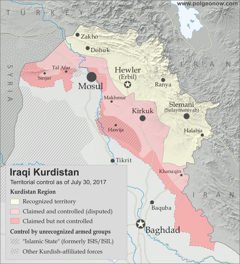
Map of Iraq and Kurdistan's place within it, published in advance of the 2017 Iraqi Kurdistan independence referendum. Includes disputed territories and territorial control as of July 30, 2017. Colorblind accessible.

October 13, 2017
Thousands of Kurdish Peshmerga troops were sent to reinforce the Kurdish-held city of Kirkuk, amid a standoff with Iraqi troops over Kurdistan’s controversial independence referendum. Kirkuk is a territory long disputed between the Kurdistan region and Iraq’s central government. Kurdistan took control of the city after it got cut off from from the rest of Iraq during the IS takeover of 2014.

The rise in tensions came after Iraqi forces took several positions near Kirkuk, including a base west of the city that had been abandoned by Kurdish fighters. An unnamed Iraqi general stated they were advancing to retake positions that were captured by the Kurds in June 2014. By nightfall, fears of an imminent battle for Kirkuk dissipated.

October 16, 2017
Iraqi government forces launched an operation to capture the province of Kirkuk and its capital from Kurdish Peshmerga forces. Government troops quickly captured several positions south of the city, including Kirkuk’s industrial district, two major oil fields and a military airbase near the city.

A Peshmerga spokesman claimed Iraqi troops “burnt houses and killed many” in an assault on the Daquq and Tuz Khurmatu areas south of the city. Two people were confirmed killed during the day in artillery shelling in Tuz Khurmatu. Later in the day, Iraqi security forces entered and seized Kirkuk city with little resistance after a surprise withdrawal by the Peshmerga. Tens of thousands of civilians also fled the city towards Kurdish-held areas.

Meanwhile, two Turkish soldiers were killed by an improvised explosive device elsewhere in northern Iraq. The Turkish military maintains a presence in western Peshmerga territory as part of efforts to combat IS, generally with the consent of Kurdistan’s government but against the will of Baghdad. Turkish forces also sometimes launch strikes on Kurdish rebels from Turkey who take shelter on the Iraqi side of the border.

Graphic of the Iraqi flag is in the public domain (source).

Kurdistan Votes to Leave Iraq: What Happens Next?

This article is part of our Referendum 2017 coverage, spotlighting controversial independence votes in two of the world’s autonomous regions: Kurdistan voted yesterday on independence from Iraq, and Catalonia will vote this Sunday on leaving Spain. 

Map of Iraq and Kurdistan's place within it, published in advance of the 2017 Iraqi Kurdistan independence referendum. Includes disputed territories and territorial control as of July 30, 2017. Colorblind accessible.

Residents of Iraqi Kurdistan voted Monday in a controversial referendum on whether to declare independence from Iraq, with preliminary results showing almost 92% in favor of separation. We’re still waiting for (hopefully) detailed official results so we can map out how different districts voted. But in the meantime, let’s answer some of the big questions:

Will Kurdistan become independent now?

The Kurdistan region’s government considers this vote official and “binding”, in contrast to an informal 2005 referendum, even though the Iraqi federal government in Baghdad considers it completely illegal. But it was never intended to trigger an automatic declaration of independence.

Instead, Kurdistan leader Masoud Barzani has promised to use a “YES” vote as leverage to negotiate independence with Iraqi government. So far, no date has been set for Kurdistan’s declaration of independence, and it could still be years away.

What if Iraq never agrees to let Kurdistan be independent?

When asked in an interview this June, Barzani said “It’s too early to say that“. But he did rule out violent means, or any end to cooperation in fighting the so-called “Islamic State” (IS; formerly ISIS/ISIL). If Kurdistan’s government eventually feels it’s reached the end of the road in negotiations with the Baghdad, it could choose to declare independence unilaterally – that is, without anyone else’s approval. But the international community rarely rewards that kind of independence declaration, and at best Kurdistan would become the next Kosovo, recognized by half the world but rejected by the other, and blocked from membership in major organizations like the UN. 

Which countries would recognize Kurdistan’s independence?

If Kurdistan successfully reaches an agreement with Baghdad before declaring independence, like South Sudan did in 2011, it will probably be recognized by almost all the world’s countries. But if it declares independence unilaterally, its prospects aren’t so good. 

Flag of Iraqi Kurdistan Unofficial Name:
• Iraqi Kurdistan (English) 
• Başûrî Kurdistan (Sorani Kurdish)
Başûrê Kurdistanê (Kurmanji Kurdish)
Kurdistān al-‘Irāq (Arabic)
Full Official Name:  
• Kurdistan Region (English)
• Herêmî Kurdistan (Sorani Kurdish)
Herêma Kurdistanê (Kurmanji Kurdish
• Iqlīm Kurdistān (Arabic)
Capital: Erbil (Hewlêr)
Status: Federal Region of Iraq

The Iraqi government and neighboring countries Iran, Turkey, and Syria all strongly opposed Kurdistan even having this referendum, and would be even more livid at an outright declaration of independence. Major world powers have been more lukewarm: The US and Germany opposed the timing of the referendum, but might be sympathetic to eventual independence, while Russia and France have declined to take sides at all.

There is one country that gave its full support to the referendum, and would be most likely to recognize an independent Kurdistan: Israel. As a country that also sees itself as the best hope for protecting a persecuted ethnic group, Israel has a lot in common with Kurdistan. Because of that, Israeli leaders would be happy to have an ally in the region who’s not friendly with Iran and doesn’t share brotherly relations with the Arab Middle Eastern countries (Kurdistan’s people are mostly Muslim, but not Arab).

But isn’t Kurdistan a great candidate for independence?

Iraqi Kurdistan is often held up as an example of an aspiring country that would actually be more stable and democratic than the existing countries in the Middle East. And that may be true: Iraqi Kurdistan has been a lot more stable lately than Iraq, Syria, or Yemen, and it’s probably more democratic than most of the countries surrounding it. But it’s not that simple: the Kurdistan Regional Government has its fair share of problems too, dominated by one political party built around a family dynasty, led by a president whose term expired two years ago, and often accused of corruption. 

Meanwhile, many outside observers worry that Kurdish independence would destabilize the region, leading to violence as neighboring countries oppose the change and Kurdish minorities in those countries become emboldened. On the other hand, many feel that the Kurds, long persecuted by other countries’ governments, deserve a country of their own regardless of the risks. And scary predictions about the future often don’t come to pass.

PolGeoNow neither supports nor opposes Kurdistan’s independence. As always, we’re just here to report what happens.

Still, the people of Kurdistan really do want independence, right?

Detailed map of territorial control in Iraq as of July 30, 2017 after the end of the Battle of Mosul, including territory held by the so-called Islamic State (ISIS, ISIL), the Baghdad government, the Kurdistan Peshmerga, and the Yezidi Sinjar Alliance (YBS and YJE). Colorblind accessible.
Full map of territorial control in Iraq (July 30, 2017)

Though 92% is surprisingly high (a poll last month found 25% planning to vote “NO”), it seems that most Kurds in Iraq do want an independent country. Although the second-largest party in Kurdistan’s parliament opposed the timing of the referendum, it supports independence in principle and decided not to the boycott the vote. 

Of course, not everyone in Kurdistan is a Kurd. The region is also home to many Turkmen, Arab, and Assyrian people (these are language-based cultural groupings; in terms of religion, Kurds, Arabs, and Turkmens are all mostly Sunni Muslims, with some Shiites and local minority religious groups, while Assyrians are mostly Christians). 

Many Arabs, who form the majority in Iraq as a whole, opposed the vote, especially in disputed territories like Kirkuk. But others supported it, having more faith in the Kurdistan government than Iraq’s. Turkmens and Assyrians were similarly split, with minority political parties representing them coming down on both sides of the debate.

Stay tuned to PolGeoNow and the PolGeoNow Twitter feed for more updates on Kurdistan, plus Catalonia’s upcoming referendum on independence from Spain! Click here to view all Referendum 2017 articles.

Graphic of the Kurdistan flag is in the public domain (source).

Referendum 2017: Iraqi Kurdistan Map

Two of the world’s autonomous regions are about to vote in controversial independence referendums. Iraqi Kurdistan decides on independence from Iraq this Monday, and on October 1 Catalonia plans to vote on leaving Spain. PolGeoNow will be covering these events with a series of articles, but in the meantime we couldn’t wait to share our new Iraqi Kurdistan map with you!

Map of Iraq and Kurdistan's place within it, published in advance of the 2017 Iraqi Kurdistan independence referendum. Includes disputed territories and territorial control as of July 30, 2017. Colorblind accessible.
Graphic by Evan Centanni and Djordje Djukic, incorporating base map by Koen Adams of onestopmap.com. All rights reserved.

Iraqi Kurdistan Independence Referendum

The Kurdistan Region of Iraq (Iraqi Kurdistan for short) is just part of the traditional homeland of the Kurds, the Middle East’s fourth-largest ethnic group after Arabs, Persians, and Turks.

Many Kurds also live in Turkey, Syria, and Iran. But Iraqi Kurdistan is where they have the most legal rights, governing themselves in what’s internationally recognized as an autonomous region within Iraq.

But all’s not well in Kurdistan-Iraq relations. Iraqi Kurds suffered through horrific violence and persecution in the 1980s and 90s, and now the region’s top politician has staked his reputation on separating Kurdistan from Iraq permanently.

Despite angry objections from Iraq’s federal government in Baghdad, as well as from neighboring countries Iran, Turkey, and Syria, the Kurdistan Regional Government (KRG) is going through with an independence vote this Monday, September 25. A “yes” vote in the referendum – which is almost guaranteed – doesn’t mean Kurdistan will immediately declare independence. But it will be seen as a serious step toward the region separating itself from Iraq once and for all.

Making matters more tense, the referendum is happening even in areas that Iraq’s federal government doesn’t consider part of the autonomous region at all –  Kurdistan has claimed these territories for years, and its military took over some of them after being cut off from the rest of Iraq by the so-called “Islamic State” (ISIS/ISIL) in 2014. But there’s not much Baghdad can do about it. The past three years have proven Kurdistan’s military to more effective than Iraq’s own, and after being left to fend for itself so long, the region is practically independent already.

Stay tuned to PolGeoNow for continuing coverage of both the Kurdistan and Catalonia referendums, and don’t forget to follow us on Twitter for more updates as events unfold!

Panama Recognizes China, Stops Recognizing Taiwan (Map)

There are newer versions of this map available. You can always find the latest version, and a list of all related articles, on our Which Countries Recognize Taiwan? page.

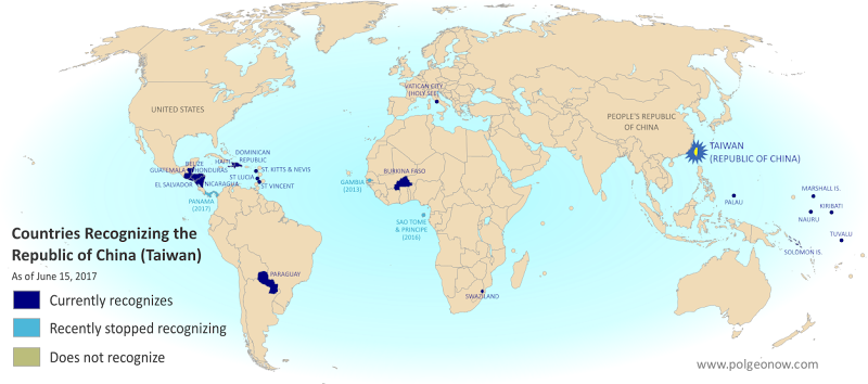
Map of who recognizes Taiwan (what countries recognize the Republic of China) in June 2017. Marks countries that have cut diplomatic ties with Taiwan (withdrawn recognition) in the last ten years: Panama, Sao Tome and Principe, and the Gambia. Also answers question: Where is Republic of China located? (Colorblind accessible)
Click to enlarge. By Evan Centanni, modified from public domain blank world map.

Article by Evan Centanni

Taiwan Loses Recognition from Panama

Flag of the Republic of China (Taiwan) Short Name (informal):  
• Taiwan (English)
• ROC (English)
• Táiwān (Chinese)
Official Name (in constitution):  
• Republic of China (English)
• Zhōnghuá Mínguó (Chinese)
Other names used officially:  
• “Republic of China (Taiwan)” (government offices)
• Chinese Taipei (international sports)
• Taiwan, Province of China (used by UN without Taiwan’s permission)   
Capital: 
Taipei (de facto)

The Central American country of Panama announced this Tuesday that it’s cutting diplomatic relations with Taiwan. Instead, it’s setting up official ties with Mainland China, endorsing the Chinese claim that Taiwan is part of China.

The island of Taiwan operates like an independent country today, but is governed under the constitution of the “Republic of China” (ROC), the government that ruled Mainland China before the communist revolution (the government that now rules the Mainland is called the People’s Republic of China).

Because the China-Taiwan dispute was originally over which side was the rightful government of China, and because the now-powerful Mainland government insists Taiwan can’t be a separate country, other countries have to choose to recognize just one or the other.

This is the first time Panama has ever recognized the People’s Republic of China, having maintained relations with the Republic of China ever since it was founded in 1912 (long before the ROC government moved to Taiwan).

Republic of China: Shrinking Recognition

Today, only 20 countries (about 10%) still have formal diplomatic relations with the Taiwan-based Republic of China government – the closest equivalent to “recognizing” Taiwan as a country. Before Panama cut ties this week, the last country to switch from Taiwan to China was São Tomé and Príncipe last December.

Only one country, the Gambia, abandoned Taiwan between 2008 and 2016, during a “diplomatic truce” initiated by Taiwan’s most Mainland-friendly president (even then, China waited until Taiwan elected a more independence-leaning president before restoring its own relations with the Gambia).

Graphic of the Republic of China (Taiwan) flag is in the public domain (source).