Map of Boko Haram/”Islamic State” Control in Nigeria: October 2015

(To see other maps in this series, view all Boko Haram updates on PolGeoNow.)
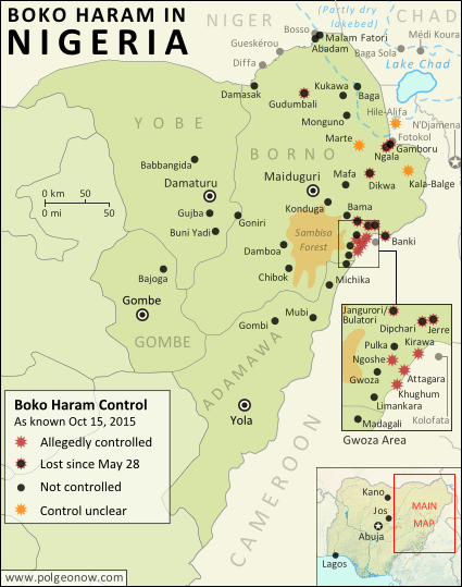
Detailed map of Boko Haram (Islamic State West Africa Province) territorial control in its war with Nigeria, marking each town reportedly under the group's control. Includes key recent locations, including Dikwa, Banki, the Sambisa Forest, and targeted areas on Lake Chad and the borders of Cameroon and Niger.
Map by Evan Centanni. All rights reserved.

(Subscribers click here to view this article in the member area) 

By Evan Centanni

The “Islamic State” in Nigeria
Northeastern Nigeria’s Boko Haram rebels, despite being pushed out of most of the territory they held last year, are still a major force in the region.

After becoming an official affiliate of Iraq and Syria’s so-called “Islamic State” (IS, a.k.a ISIS/ISIL) last March, they have now taken to calling themselves the Islamic State’s West Africa Province (ISWAP).

Status of Territorial Control
The goal of IS is to capture and hold territory, and Boko Haram still hangs on by a thread in that respect. Though the extent of their control has been blurry over the past six months (there is extremely little independent reporting from the region), military forces of Nigeria and neighboring countries have continued to announce the “recapture” of towns – an implicit acknowledgment that territory continues to be hotly contested.

Since this summer, the Nigerian government has stepped up aerial attacks against Boko Haram hideouts in the Sambisa Forest, but the result seems to have been a flood of fighters into nearby communities on border with Cameroon, while the forest remains an area of murky control.
Flag of NigeriaCountry Name:  
• Nigeria (English)*
Official Name:  
• Federal Republic of Nigeria (English)*
Capital: Abuja
*There are hundreds of local and regional languages in Nigeria, but only English has official status.

Chronology of Events
The following is a timeline of major events and changes to territorial control in northeastern Nigeria and neighboring countries since our previous update of May 28, 2015.

Note that Boko Haram launches deadly attacks on an almost daily basis across northeastern Nigeria, frequently on Cameroon’s side of the border, and occasionally in Niger and Chad as well. This timeline focuses on changes of territorial control, adding in selected items representing the biggest news and most significant cross-border incidents.

2015.06.14 Boko Haram fighters sacked the town of Babbangida, north of Yobe state capital Damataru.

2015.06.15 Boko Haram carried out a bombing with heavy casualties in N’Djamena, the capital city of Chad. An important Boko Haram leader would be captured in the city two weeks later.

2015.06.17-23 A deadly Boko Haram attack on Gueskérou, Niger was answered with a five-day long air and ground campaign by that country’s armed forces.

2015.07.01-02 Boko Haram killed almost 200 people in two days, in a wave of attacks across Borno state. As of last March, Boko Haram considers itself the West African branch of the Syria- and Iraq-based “Islamic State” (a.k.a. ISIS/ISIL). The July violence in Nigeria, targeted at non-extremist Muslims, coincided with an IS directive to increase attacks during the Muslim holy month of Ramadan.

2015.07.22 A village in the Hile-Alifa area of Cameroon was reportedly occupied by Boko Haram, two days after a brutal rebel attack on the nearby town of Kamouna.

2015.07.24 The Nigerian army said it recaptured Dikwa from Boko Haram, though the town had already been reported secured by Chadian forces in March.

2015.07.25 Boko Haram attacked the island of Médi Koura among the fragmented remains of Lake Chad, well within the borders of Chad itself. The attack would be followed by major military campaign and heavy fighting in nearby areas, as Chadian troops attempted to drive Boko Haram forces entirely out of the lake region.

2015.08.02 The Nigerian army said it rescued 178 prisoners from Boko Haram, most of them children and women. The 200 missing girls infamously kidnapped from Chibok in 2014 were not among them.

2015.08.21 An army source reported that troops had driven Boko Haram fighters out of Gudumbali.

2015.09.01 Nigerian government forces captured Gamboru-Ngala from Boko Haram. The twin towns had been secured by Chadian forces months earlier, but not protected from subsequent rebel incursions.

2015.09 In early September, Boko Haram fighters began attacking communities on the border with Cameroon after being flushed out of the Sambisa Forest by a heavy government bombing campaign. The attacks included the storming of a market in downtown Kirawa, a town known to have been under Boko Haram control in the past.

2015.09.19 A military spokesman said Nigerian troops had captured Jerre and Dipchari, on the road to Banki.

2015.09.20 A Nigerian newspaper reported that Boko Haram was operating a checkpoint on the road between Gwoza and Limankara, killing any travelers who did not have food to offer to the rebels.

Map of Boko Haram control in Nigeria in March 2015, and the multinational offensive with Cameroon, Chad, and Niger that drove the rebels back.
Multinational offensive against Boko Haram, Jan. to Mar. 2015

2015.09.22 Nigerian troops cleared Boko Haram fighters from camps in Jangurori and Bulatori, near Bama. In the process a high-level Boko Haram leader was captured.

2015.09.24 The Nigerian military said it seized Banki, on the border of Cameroon, with cooperation from the Cameroonian military. The next day, “at least 200” Boko Haram fighters allegedly surrendered to the government forces.

2015.09.23-25 Madagali, at the northern tip of Adamawa state, was reportedly abandoned by its population after three consecutive days of Boko Haram raids.

2015.10.07 The military claimed that over 100 Boko Haram fighters were killed in a failed attack on troops in Goniri, on the Borno-Yobe state line.

2014.10.08 An open letter from displaced residents to President Buhari said Boko Haram was in control of a number of villages east of Gwoza, including Ngoshe, Attagara, Kirawa, and Kughum.

2014.10.10 Dozens were killed in a Boko Haram attack on a fish market in Baga Sola, on Chad’s side of the border.

2015.10.14 The US announced it was sending 300 troops to Cameroon to assist in tracking down Boko Haram fighters.

Following this story? View all Boko Haram maps on PolGeoNow!

Timeline compiled with the help of the ACLED dataset (Raleigh, Clionadh, Andrew Linke, Håvard Hegre and Joakim Karlsen. 2010. Introducing ACLED-Armed Conflict Location and Event Data. Journal of Peace Research 47(5) 651-660.)

Graphic of the Nigerian flag is in the public domain (source).
Map of Boko Haram Control in Nigeria: March 2015 (Subscription)

The best online map of Boko Haram’s territorial control – guaranteed!

There are newer versions of this map available. To see them, view all Boko Haram updates.

Detailed map of Boko Haram's territorial control in its war with Nigeria, marking and labeling each town reportedly under the group's control in Borno, Yobe, and Adamawa states. Includes illustration of multinational campaign against the group by Nigeria, Chad, and Niger.

Download PDF:
Buy now

(Subscribe via Paypal to view all premium content online)

Research by T.H., with additional reporting by Evan Centanni

Boko Haram has now allegedly teamed up with the Islamic State, but the Nigerian rebel group has recently lost most of its territory to a multi-pronged military campaign involving Nigeria, Chad, Niger, and Cameroon.

This map report illustrates the offensive against Boko Haram and the rebel group’s remaining territorial holdings, and includes a summary and timeline of events since our previous Boko Haram map report in January.

This map report is exclusive premium content, available to paid subscribers or for separate purchase. Buy now (US$14.99)

Exclusive map report includes:

  • Map of Boko Haram’s overall area of control in Nigeria, updated to March 22, 2015.
  • Detailed map showing almost every individual town currently or previously held by Boko Haram, as well as the overall extent of rebel territorial control.
  • Illustrations of the five major military campaigns that have driven Boko Haram back over the past two months, as well as key locations in neighboring countries.
  • Summary and detailed timeline of territorial changes and major events since late January, with links to sources.

MEMBERS CLICK HERE TO PROCEED TO ARTICLE AND MAP

NOT A MEMBER YET? SUBSCRIBE NOW!

Nigeria War Update: Map of Boko Haram Control (January 2015) (Premium)

The best online map of Boko Haram’s territorial control – guaranteed!

There are newer versions of this map available. To see them, view all Nigeria updates.

Detailed map of Boko Haram's territorial control in its war with Nigeria, marking and labeling each town reportedly under the group's control in Borno, Yobe, and Adamawa states. Includes recent flashpoints such as Maiduguri, Damataru, Konduga, and Monguno, as well as sites of attacks in Cameroon.

Download PDF
Buy now

(Subscribe via Paypal to view all premium content online)

Research by T.H., with additional reporting by Evan Centanni

Since our last Boko Haram control map update in November, the rebel group has expanded its territorial control in Nigeria, connecting two of its territorial enclaves and occupying a long stretch of the country’s international border with Niger, Chad, and Cameroon.

This premium report and map detail the various changes of the past two months, including new Boko Haram conquests as well as key attacks that didn’t result in territorial gains. The map also, of course, provides an updated illustration of the full extent of Boko Haram’s territorial control.

This map and article are exclusive premium content, available only to paid members or for individual purchase. Buy now (US$9.99)

Premium report includes:

  • Map of Boko Haram’s overall area of control in Nigeria, updated to Jan. 28, 2015.
  • Detailed map showing almost every individual town or village known to be held by the group, as well as recent locations of major attacks, such as Baga, Monguno, Maiduguri, and Damataru. 
  • Also shows attacks across the border in Cameroon.
  • Summary and detailed timeline of territorial changes and major events since late November, with sources cited.

MEMBERS CLICK HERE TO PROCEED TO ARTICLE AND MAP

NOT A MEMBER YET? SUBSCRIBE NOW!

War in Nigeria: Map of Boko Haram Control (September 2014)

There are newer versions of this map available. To see them, view all Nigeria updates.

Detailed map of Boko Haram territorial control in its war with Nigeria, marking and labeling each town reportedly under the group's control in Borno, Yobe, and Adamawa states. Includes Damboa, Buni Yadi, Madagali, Gwoza, Gujba, Gulak, Bama, Gulani, Shuwa, Marte, Kukawa, Michika, Dikwa, Bularafa, Bazza, Gambaru Ngala, Buni Gari, Banki, Bara, Pulka, Bumsa, Ashgashiya, Limankara, Njibulwa and more.
Map by Evan Centanni. All rights reserved.

Premium members click here to view this article in the ad-free members area. Not a member yet? Sign up now!

Conflict tracking by T.H., with additional reporting by Evan Centanni

Boko Haram vs. Nigeria
Though it’s waged a bloody war against the Nigerian government for many years, rebel group Boko Haram rarely could claim significant territorial control until recently. Though they did take over a number of remote areas in spring of last year (see our 2013 Boko Haram control map), the militants were soon driven back into hiding by the Nigerian military.

The insurgency never went away, with Boko Haram’s bombings and other attacks, often on schools and other public places, increasing in number and lethality from 2013 into early 2014. (Also see our 2013 report for more background on Boko Haram).

Territorial Resurgence
However, this summer saw a striking change in the trajectory of Boko Haram’s rebellion. Likely inspired by the Islamic State organization in Iraq and Syria, Boko Haram initiated a new strategy of capturing and holding towns and villages. The campaign began in late July, and has gone much farther than last year’s seizure of several small towns. By early September there was talk of an imminent invasion of Maiduguri, the capital of Nigeria’s far northeastern Borno State. That hasn’t happened yet, but neither does Boko Haram seem to be abandoning its newly won territory anytime soon.

Flag of NigeriaCountry Name:  
• Nigeria*
Official Name:  
• Federal Republic of Nigeria*
Capital: Abuja
*There are hundreds of local languages in Nigeria, but only English is official.

Chronology of Events
The following is a timeline of major events and changes to territorial control since Boko Haram began seizing towns in northeastern Nigeria this summer.

2014.04.15 Boko Haram kidnaps hundreds of schoolgirls in Chibok, Borno State, gaining attention from around the world. At this time, Boko Haram is not yet known to hold any clearly-defined territory. As of September 2014, the Chibok girls are apparently still missing, and the town is said to be abandoned.

2014.07 Boko Haram erects tollgates on major routes in northern and central Borno State, where it holds rural influence.

2014.07.21 Boko Haram reportedly captures Damboa, raising its flag over the major Borno town.

2014.07.23 Boko Haram destroys a bridge between Maiduguri and Ngala, Borno State. Current control of Damboa is unclear, but there is no government presence.

2014.07.28 Apparent consensus that Boko Haram controls Damboa and the surrounding local government area

2014.08.03 Around this time, Boko Haram takes over Gujba, its first town captured in Yobe State.

2014.08.06 Boko Haram seizes the key town of Gwoza in Borno.

2014.09.10 Around this time, Boko Haram occupies the town of Ashigashia just outside Nigeria’s borders, in neighboring Cameroon.

2014.08.11 Nigerian government claims to have recaptured Damboa. A month later, the town is reportedly still deserted.

2014.08.17 Over the weekend, Boko Haram reportedly takes control of Michika in Adamawa State, but the town will be more widely reported as captured three weeks later.

2014.08.21 Boko Haram takes Buni Yadi in Yobe State.

2014.08.21 Boko Haram captures Madagali, Adawama State.

2014.08.23 Boko Haram takes over Pulka, Borno State.

2014.08.24 Media report that Boko Haram leader Abubakar Shekau has declared a “caliphate” (Islamic empire) in Gwoza, but he may only have meant that it was now ruled according to Islamic law.

2014.08.25 Boko Haram captures Ngala and Gambaru, Borno State.

2014.08.28 Boko Haram captures Dikwa and Marte, Borno State.

2014.08.29 Cameroon’s military retakes Ashigashia town from Boko Haram.

2014.09.01 Boko Haram attacks Bama, Borno State.

2014.09.02 Bara in Yobe State captured by Boko Haram.

2014.09.02 Boko Haram allegedly captures Bama, a major town in Borno, but the situation remains unclear.

2014.09.03 Boko Haram seizes Banki in Borno State and Gulani in Yobe State.

Map of Boko Haram control in Nigeria in May 2013
Boko Haram control in Nigeria, 2013 (click for free map and report).

2014.09.07 Boko Haram captures town of Gulak, Adamawa State.

2014.09.08 Boko Haram captures Michika, Adamawa State. Government claims to recapture Bama.

2014.09.10 Nigerian military claims to recapture Michika, Uba, and Gulak.

2014.09.11 Bama residents say Boko Haram controls the town, despite continued government insistence to the contrary.

2014.09.13 Unidentified Boko Haram commander reportedly captured during attempt to occupy Konduga.

2014.09.18 Catholic Church source says Boko Haram now controls 25 towns. In addition to locations already mentioned, the list includes Shuwa, Kukawa, Bularafa, Bazza, Buni Gari, Bumsa, Taltaba*, Limankara, and Njibulwa. Michika, Gulak, and Ashigashia are also still listed despite earlier claims they were retaken by government forces. A longer accounting of “31 towns and villages” adds Wulgo, Ngoshe, Attagara, Barawa*, Arbokko, Kirawa.

2014.09.19 Nigerian government begins investigating the possible death of Boko Haram leader Abubakar Shekau. The army of Cameroon also took credit for Shekau’s death, but some believe he was actually killed over a year ago, and that the recent death was of an imposter.

2014.09.26 Boko Haram again tries to capture Konduga, on the way into Borno State capital Maiduguri, but is stopped by government forces.


*PolGeoNow was unable to determine the precise geographical locations of Taltaba and Barawa. For this reason, they do not appear on the above map.

Don’t miss future updates to the map of Boko Haram control in Nigeria! Become a member now!

Graphic of the Nigerian flag is in the public domain (source).