Map of Control in Yemen’s Civil War: February 2016 (Subscription)

MEMBERS CLICK HERE TO PROCEED TO ARTICLE AND MAP

There are newer versions of this map available. To see them, view all Yemen updates.
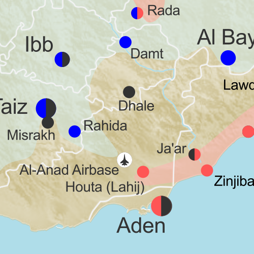
Map of territorial control in Yemen as of February 19, 2016, including territory held by the Houthi rebels and former president Saleh's forces, president-in-exile Hadi and his allies in the Saudi-led coalition and Southern Movement, Al Qaeda in the Arabian Peninsula (AQAP), and the so-called Islamic State (ISIS/ISIL). Includes recent areas of Al Qaeda takeovers and locations of other fighting, such as Shuqrah, Azzan, Habban, Ahwar, Misrakh, Fardat Nahm, and more.

Subscribe for full access to all conflict map reports!

Download PDF:
Buy now
New discounted price!

Timeline by Djordje Djukic, with additional reporting by Evan Centanni; map by Louis Martin-Vézian and Evan Centanni

Though it’s been less than three weeks since our last Yemen control map update, there have already been several changes to territorial control. Most notably, Al Qaeda in the Arabian Peninsula (AQAP) has rapidly expanded its territory, recapturing most of the towns it held from 2011 to 2012.

Meanwhile, the Saudi-led coalition supporting President Hadi has also made progress against the Houthi rebels over the past weeks.

See all this and more on the newest update to PolGeoNow’s Yemen territorial control map, which includes a timeline of changes and important events since our previous Yemen map report at the end of January.

This map and report are exclusive premium content, available to paid subscribers or for individual purchase. Download PDF (US$14.99) New discounted price!

Want to see before you buy? Check out our most recent FREE SAMPLE Yemen map report!

Exclusive map report includes:

Map of territorial control in Yemen as of February 19, 2016, including territory held by the Houthi rebels and former president Saleh's forces, president-in-exile Hadi and his allies in the Saudi-led coalition and Southern Movement, Al Qaeda in the Arabian Peninsula (AQAP), and the so-called Islamic State (ISIS/ISIL). Includes recent areas of Al Qaeda takeovers and locations of other fighting, such as Shuqrah, Azzan, Habban, Ahwar, Misrakh, Fardat Nahm, and more.
  • Up-to-date map of current territorial control in Yemen, color-coded for the pro-Hadi coalition, Houthi/Saleh forces, Al Qaeda in the Arabian Peninsula (AQAP), and “Islamic State” (ISIS/ISIL).
  • Color scheme recently updated for consistency with Syria, Iraq, and Libya map series
  • Detailed indication of town-by-town control, including provincial boundaries, all major cities, and many smaller ones
  • Markers for recent areas of Al Qaeda takeovers and locations of other fighting, such as Shuqrah, Azzan, Habban, Ahwar, Misrakh, Fardat Nahm, and more
  • Timeline of changes to the situation since January 31 2016, with links to sources

MEMBERS CLICK HERE TO PROCEED TO ARTICLE AND MAP

Not a member yet? Click here to learn more about our professional subscription service!
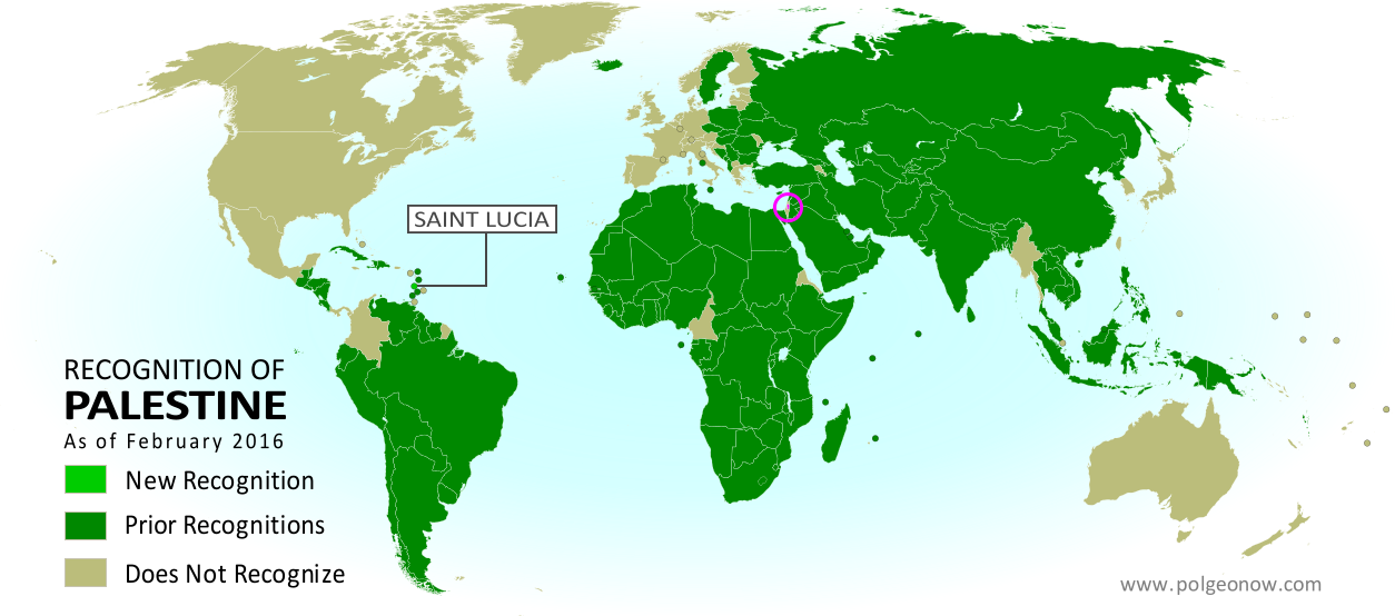
Map: Which Countries Recognize Palestine as Independent in 2016?

(Keep up with changes to Palestine’s situation: view all Palestine updates.)

Map of countries that recognize the State of Palestine as an independent country, updated for February 2016 with recent addition Saint Lucia highlighted
Click to enlarge. Palestine in magenta (circled). Map by Evan Centanni, modified from public domain graphic (source).

Subscribers click here to view this article in the ad-free members area. Not a member yet? Learn about PolGeoNow subscriptions!

Article by Evan Centanni

Disputed Country

The Palestinian Liberation Organization (PLO) declared an independent State of Palestine in 1988, and continues to pursue its recognition as a country today. Though Palestine’s claimed territories are disputed and largely occupied by Israel, it has gathered recognition from more than two-thirds of the world’s countries, and is also treated as a country by the UN General Assembly, where it’s an “Observer State” but not a member.

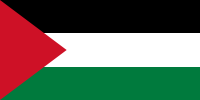
Flag of Palestine Country Name:  
• Palestine (English)
Filasṭīn (Arabic)
Official Name:  
• State of Palestine (English)
• Dawlat Filasṭin (Arabic)
Capital: 
• Jerusalem (claimed)
Ramallah (administrative)

The number of individual countries recognizing Palestine has grown gradually over the past decades. Last June we reported that 135 U.N. member states (and one observer state) officially recognized Palestine, and since September the number is now 136 (about 70% of all UN members). Palestine is also recognized by the proclaimed government of Western Sahara, another disputed country that’s not formally recognized by the UN.

Saint Lucia Recognizes Palestine

Last September, the small Caribbean island country of Saint Lucia became the latest national government to recognize Palestine as independent. The formal acknowledgement came on September 14, 2015, when the two countries’ UN representatives signed an agreement in New York to establish diplomatic relations.

Saint Lucia is now one of about half the world’s countries whose government recognizes both Palestine and Israel as independent countries. All of the independent Caribbean countries except Cuba recognize Israel, and most also recognize Palestine, with the exception of Jamaica, the Bahamas, Saint Kitts and Nevis, Barbados, and Trinidad and Tobago.

Read More:
Is Palestine Really a Country?
Palestine Recognized as a Country by the UN
Map of Countries Recognizing Kosovo

Syrian Civil War Control Map: February 2016 (Subscription)

MEMBERS CLICK HERE TO PROCEED TO ARTICLE AND MAP

There are newer versions of this map available. To see them, view all Syria updates.

Research by Djordje Djukic. Map by onestopmap.com and Evan Centanni.

Subscribe for full access to all conflict map reports!

Download PDF:
Buy now
New discounted price!

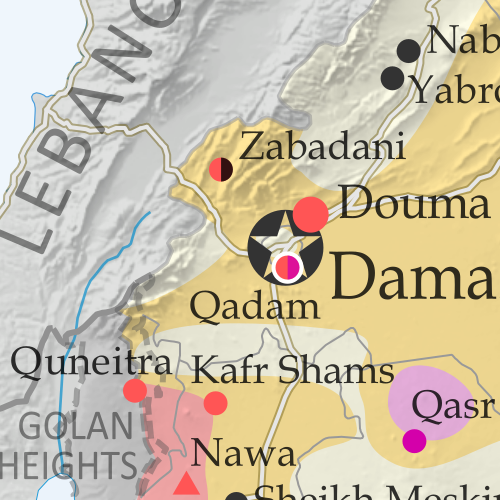
Map of fighting and territorial control in Syria's Civil War (Free Syrian Army rebels, Kurdish YPG, Syrian Democratic Forces (SDF), Al-Nusra Front, Islamic State (ISIS/ISIL), and others), updated for February 2016. Now includes terrain and major roads (highways). Highlights recent locations of conflict and territorial control changes, such as Menagh airbase, northern Aleppo, Salma, Rabia, Nubl, Baghaliya, Tishrin Dam, and more.New: Improved map now includes terrain and major roads!

As a UN-brokered truce approached, tables were beginning to turn in Syria, with the government’s Russian-backed offensive making major breakthroughs against rebel forces in Aleppo, Latakia, and elsewhere. 

Meanwhile, the so-called “Islamic State” (ISIS) continued to hold vast tracts of the country, while Kurdish-led forces gradually expanded their control in victories against ISIS and rebel fighters alike.

See all this and more on the newest update to PolGeoNow’s concise, professional Syrian Civil War control map, which includes a timeline of changes since our previous Syria map report in mid-December.

This map and report are professional subscriber content, available to paid members or for separate purchase. Download PDF (US$14.99) New discounted price!

Want to see before you buy? Check out our most recent FREE SAMPLE Syria map!

Exclusive map report includes:

Map of fighting and territorial control in Syria's Civil War (Free Syrian Army rebels, Kurdish YPG, Syrian Democratic Forces (SDF), Al-Nusra Front, Islamic State (ISIS/ISIL), and others), updated for February 2016. Now includes terrain and major roads (highways). Highlights recent locations of conflict and territorial control changes, such as Menagh airbase, northern Aleppo, Salma, Rabia, Nubl, Baghaliya, Tishrin Dam, and more.
  • New in this edition: Terrain shading and major highways included on map for geographic context!
  • Up-to-date map of current territorial control in Syria, color-coded for the Assad government, rebel groups, “Islamic State” (ISIS/ISIL) extremists, and Kurdish YPG forces. 
  • Special symbols indicate towns dominated by rebels of Al Qaeda affiliate Jabhat al-Nusra (the Nusra Front) and by multi-ethnic anti-ISIS Syrian Democratic Forces (SDF).
  • Detailed indication of city-by-city control, highlighting key towns and other locations important to current events.
  • Locations of recent fighting and military operations, including Menagh airbase, Aleppo, Salma, Rabia, Nubl, Baghaliya, Tishrin Dam, and more.
  • Detailed timeline of important events and changes to territorial control since December 9, 2015, compiled by our Syria-Iraq expert, with links to sources.

MEMBERS CLICK HERE TO PROCEED TO ARTICLE AND MAP

Not a member yet? Click here to learn more about our professional subscription service!