Kosovo Becomes an Olympic Nation

Premium members click here to view this article in the ad-free members area. Not a member yet? Subscribe now!

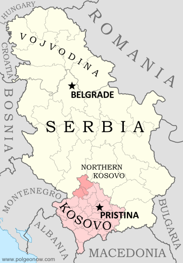
Map of Serbia, Kosovo, and North Kosovo
Kosovo controversially claims independence from Serbia (Northern Kosovo is under partial pro-Serbian control). Map by Evan Centanni, based on these two blank maps by Nord-NordWest. License: CC BY-SA

By Evan Centanni

Next Stop: Rio 2016
Disputed country Kosovo has become the 205th member of the International Olympic Committee (IOC), making it an official Olympic Nation and allowing it to field a team at the 2016 Olympics in Brazil. Its full acceptance came at an IOC meeting in Monaco on December 9, after being granted “provisional recognition” in October.

Kosovo’s admission process has been ongoing for five years, and the self-proclaimed country was denied the chance to participate in the London Olympics of 2012. However, one Kosovan athlete attended the games with the team from Albania, a neighboring country with close cultural ties to Kosovo.

Disputed Status
Located in southeastern Europe, Kosovo controversially declared independence from Serbia in 2008, while under the control of UN peacekeepers. Since then, it has been recognized as independent by over half of the world’s countries, including the US and most of the European Union. However, Russia, China and many other countries still consider it to be rightfully part of Serbia.

Flag of the Republic of KosovoCountry Name:  
• Kosovo (English, Serbian)
• Kosova (Albanian)
Official Name:  
• Republic of Kosovo (English)
Republika e Kosovës (Albanian)
Republika Kosovo (Serbian)
Capital: Pristina/Prishtina

Serbia strongly opposed Kosovo’s admission into the Olympics, arguing that Kosovan athletes had been invited to join the Serbian team. However, in the name of good sportsmanship, Serbia’s Olympic committee has declined to file a formal protest.

Rules and Precedents
Kosovo will become one of only three disputed countries allowed to send teams to the Olympics, after Taiwan (participating as “Chinese Taipei“) and Palestine. Other breakaway states, like Western Sahara, Abkhazia, and Northern Cyprus, are still shut out.

Most Olympic Nations are fully-recognized UN member countries, but the rules don’t explicitly require that. Official IOC regulations say only that every new member must be an “independent State recognised by the international community“. This has often been assumed to mean UN membership, but the IOC apparently decided it’s good enough to be recognized individually by 107 out of 193 UN member countries.

The last time the IOC admitted new members was in 2007, when Montenegro and Tuvalu both joined. Both of those countries were members of the UN prior to becoming Olympic Nations.

See Also: 
Which Countries Are (and Aren’t) in the Olympics?
Which Countries Recognized Kosovo as Independent?
 

Flag graphic by Cradel (source). License: CC BY-SA

Ukraine War Rebel Control Map: December 2014 (Premium)

There are newer versions of this map available. To see them, view all Ukraine updates.

Detailed map of pro-Russian rebel control in Ukraine's eastern provinces of Donetsk and Luhansk, claimed by the breakaway Donetsk People's Republic and Lugansk People's Republic. Updated to December 21, 2014

Download PDF
Buy now

(Subscribe via Paypal to access all premium content online)

Research by Djordje Djukic, with additional reporting by Evan Centanni

Control lines have begun to solidify in Ukraine’s civil war, with government forces on one side and the fighters of the self-proclaimed Donetsk People’s Republic, Lugansk People’s Republic, and Federation of Novorossiya on the other side. 

PolGeoNow presents our district-by-district map of control in eastern Ukraine, updated for December 2014, including a timeline of major events and changes to territorial control since our previous Ukraine map update in September.

This map report is exclusive premium content, available to paid subscribers or for individual purchase.
Buy now (US$9.99)

Premium map includes:

  • Detailed, updated map of Donetsk and Luhansk regions, showing both past and current rebel control
  • Indication of which districts and cities have had their administrations occupied by separatists
  • Timeline of changes to territorial control since September, and summary of major trends

MEMBERS CLICK HERE TO PROCEED TO ARTICLE AND MAP

NOT A MEMBER YET? SUBSCRIBE NOW!

Map: Which Countries Recognize Palestine in 2014?

(Keep up with changes to Palestine’s situation: view all Palestine updates.)

Map of countries that recognize the State of Palestine as an independent country, updated for December 2014 with recent addition Sweden highlighted
Countries recognizing the State of Palestine in green, with most recent addition highlighted. Palestine in magenta (circled). Click to enlarge. Map by Evan Centanni, modified from public domain graphic (source).

Premium members click here to view this article in the ad-free members area. Not a member yet? Subscribe now!
Article by Evan Centanni

Disputed Country
Palestine declared independence in 1988, and its government continues to pursue recognition as a country today. Though its claimed territories are disputed and largely occupied by Israel, the “State of Palestine” has gathered recognition from more than two-thirds of the world’s countries, and is also treated as a country by the U.N. General Assembly, where it is an “Observer State” but not a member.

The number of individual countries recognizing Palestine as independent has grown gradually over the past decades. A year ago we reported that 134 U.N. member states officially recognized Palestine, and as of December 2014 the number is now 135 (70% of all U.N. members). Palestine is also recognized by the proclaimed government of Western Sahara, another disputed country that’s not formally recognized by the U.N.

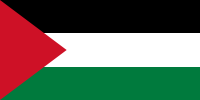
Flag of Palestine Country Name:  
• Palestine (English)
Filasṭīn (Arabic)
Official Name:  
• State of Palestine (English)
• Dawlat Filasṭin (Arabic)
Capital: 
• Jerusalem (claimed)
Ramallah (administrative)

Sweden’s Recognition of Palestine
Only one new country has endorsed Palestine’s independence in 2014, but it’s a big one. On October 30, Palestine was officially recognized by Sweden, a major European country and and member of the European Union (EU). This is a big deal because most of Western Europe does not recognize Palestine, and of the 50-60 total countries worldwide that don’t recognize, about half are in Europe.

Palestinian Recognition in Europe
Sweden is the first country to begin recognizing Palestine after becoming a member of of the EU, an organization that tends to take a centrist stance on the Israeli-Palestinian conflict. In recent months, legislatures in France, Spain, Ireland, and the UK have also voted in support of recognizing Palestine, but so far none of their governments has followed through with official recognition.

However, Sweden isn’t the only EU country that endorses Palestine’s claimed independence: Malta, Czechoslovakia, Cyprus, Hungary, Romania, Bulgaria, and Poland all recognized it in 1988, before they became EU members.* Russia, Belarus, Ukraine, Serbia, and Albania also retain recognition from 1988, but are not members of the EU. And yet, neither is Sweden the only European country to recognize Palestine since the end of the Cold War. Bosnia recognized in 1992, Montenegro in 2006, and Iceland in 2011. 

*After the breakup of Czechoslovakia, the Czech Republic and Slovakia inherited their recognition of Palestine, though the current Czech government does its best to ignore that fact, having become a very close ally of Israel. Cyprus, on the other hand, has recently reaffirmed its original position on Palestinian independence. 

Related Articles:
Is Palestine Really a Country?
Palestine Recognized as a Country by the U.N.
Map of Countries Recognizing Kosovo

Syria Civil War Map: December 2014 (Premium)

There are newer versions of this map available. To see them, view all Syria updates.

Detailed map of territorial control in Syria's Civil War (Free Syrian Army and Nusra Front rebels, Kurdish groups, ISIS/ISIL/Islamic State and others), updated to December 2014 for siege of Kobani (Ayn al-Arab), government capture of Morek, rebel capture of Nawa, and other developments.

Download PDF
Buy now

(Subscribe via Paypal to view all premium content online)

Research by T.H., with additional reporting by Evan Centanni

Our popular map of territorial control in the Syrian Civil War has been updated for December 2014, showing changes to the situation since the previous Syria map report in October. 

The map and accompanying report show largely unreported advances by the Islamic State, as well as important gains for both the government and rebels.

This map and report are exclusive premium content, available to paid subscribers or for individual purchase.
Download PDF (US$14.99)

Premium map includes:

  • Up-to-date map of current territorial control in Syria, color-coded for the Assad government, rebel groups, Islamic State (ISIS) extremists, and Kurdish self-protection forces
  • Detailed indication of city-by-city control, highlighting key towns relevant to current events
  • Recent areas of fighting, including Kobani (Ayn al-Arab), Morek, Nawa, and many others
  • Timeline of events since early October, with focus on changes to territorial control

MEMBERS CLICK HERE TO PROCEED TO ARTICLE AND MAP

NOT A MEMBER YET? SUBSCRIBE NOW!