Interactive Maps: Which Places Switched Time Zones in 2016?

This article is a spin-off from our popular yearly review of political geography events. For more on changes to countries and borders in 2016, check out our main 2016 year in review article! 

A time zone map of the world, showing all the world's standard time zones as of the beginning of 2017, with UTC offsets.
Free map of world time zones from Wikimedia Commons, up-to-date for the beginning of 2017. See the close-ups below for interactive, before-and-after illustrations of time zone changes during 2016.

Article and additional graphics work by Evan Centanni
 

Who Controls Time Zones?

The system of dividing the world into time zones is accepted all around the world, in principle. It’s an organized way of letting clocks in each part of the world hit noon around the middle of daylight hours, even if it’s midnight on the other side of the world. But surprisingly, there’s actually no international organization that determines time zones. Except for in the open ocean, where time zones are standardized by a loose agreement between fleets and ship operators, the dividing lines are set independently by each country’s government, or even by local governments below the national level.

Many governments choose one time for the whole country, putting themselves unofficially inside a bigger time zone with other countries that set their clocks to the same time. Others, especially if their territory is very wide from west to east, divide the country up into several time zones. And while most time zones are defined as being a whole number of hours different from Coordinated Universal Time (UTC; a modern version of the outdated “Greenwich Mean Time”), some choose to align their clocks more precisely with the cycles of the sun by shifting them a half hour or even a quarter hour forward or back.

Who Changed Their Time Zones in 2016?

Depending on a country’s laws, redrawing the boundaries between time zones can be as simple as a local assembly voting to reset the area’s clocks, or a president signing an order to modify the nation’s time zones. Last year, there were quite a few of these changes, which you can see by tapping on the maps below (if you’re using a touchscreen) or hovering your cursor over the maps (if you’re using a mouse).
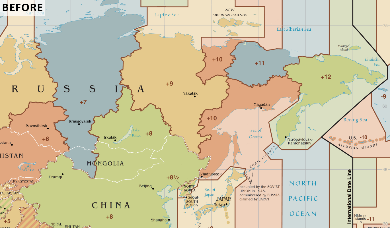
Before and after: Interactive map of time zones that changed during 2016 in Siberia and the Russian Far East
Before and After: Tap or hover your mouse over the map to see which time zones changed shape during 2016 in eastern Russia (see next map below for changes in western Russia)

Russia’s Year of Time Changes

Russia dominated the time zone news in 2016, with ten different regions of the country all moving their clocks forward an hour at different times during the year. The end result was a major redrawing of four different time zone boundaries. Russia has a history of time zone changes, with tweaks or major shifts happening every few years since the 1980s, so this wasn’t a huge surprise.

The 2016 changes started off in January, with the announcement that President Vladimir Putin had signed off on a time change for the Zabaykalsk territory of Siberia. The region would set its clocks one hour forward on March 27, moving from Irkutsk Time (UTC +8) to Yakutsk Time (UTC +9). Not long afterwards, he approved a second time change, this one for Astrakhan province in Russia’s southwest. Astrakhan would also set clocks one hour forward, on the same day as Zabaykalsk, leaving Moscow Standard Time (UTC +3) to join Samara Time (UTC +4).

Within weeks, several more changes had been announced for Russia’s March 27 time zone shift:

  • Sakhalin province in Russia’s Far East would set clocks an hour forward, switching from Vladivostok Time (UTC +10) to Srednekolymsk Time (UTC +11)
  • Western Siberia’s Altai Republic and Altai territory would both set clocks an hour forward, switching from Omsk Time (UTC +6) to Krasnoyarsk Time (UTC +7)
  • Ulyanovsk province in Western Russia would join Astrakhan in setting clocks an hour forward from Moscow Time (UTC +3) to Samara Time (UTC +4)

But that wasn’t the end of it. On April 24, less than a month after the big March changes, the far eastern Magadan province also moved an hour forward, leaving Vladivostok Time (UTC +10) to join Sakhalin and Srednekolymsk in the UTC +11 time zone, which was then renamed Magadan Time.
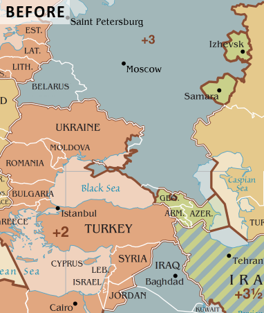
Before and after: Interactive map of time zones that changed during 2016 in west Asia and southeastern Europe
Before and After: Tap or hover to see which time zones changed shape in 2016

The next month, on May 29, yet another Russian region set its clocks forward an hour, with western Siberia’s Tomsk province joining the Altai Republic and Altai territory in moving from Omsk Time (UTC +6) to Krasnoyarsk Time (UTC +7). Then, on July 24, Siberia’s biggest city jumped on the bandwagon, with Novosibirsk province joining the neighboring Tomsk and Altai regions in setting clocks an hour forward (the previous changes had left it an hour behind most of the surrounding areas).

Before the year was done, one more Russian region had switched time zones. On December 4, Saratov province joined Astrakhan and Ulyanosk in setting its clocks forward an hour from Moscow Time (UTC +3) to Samara Time (UTC +4).

Other Countries That Changed Their Time Zones in 2016

Besides Russia, there were a few other countries that carried out time zone changes last year. Not far away from some of the changing Russian time zones, Turkey made a shift of its own. Until late 2016, Turkey’s standard time zone was UTC +2, just like every other country on the eastern Mediterranean, such as Greece, Syria, Israel, and Egypt. During the summer, Turkey would set clocks temporarily forward an hour, a common practice that’s known as daylight saving time (DST). 

But in September, Turkey’s government decided not to set clocks back to the normal time for winter anymore, leaving the country permanently in UTC +3, alongside Moscow, Saudi Arabia, and East Africa. Not to be left-behind, the self-declared Turkish Republic of Northern Cyprus quickly decided to join its sponsor country in the time zone change, leaving the island of Cyprus split awkwardly between different time zones for its northern and southern areas.

Back in 2015, Chile had done the same thing as Turkey, shifting forward an hour from UTC -4 to UTC -3 by canceling the end of daylight saving time. But in 2016 the country reversed course, reintroducing DST changes so the country’s mainland would return to UTC -4 in the winter. 

The remote Chilean territory of Easter Island, known locally as Rapa Nui, is two hours behind the rest of the country, but follows the same DST rules. So after the 2015 change, Easter Island was permanently in the UTC -5 zone, even though the seas surrounding it are loosely considered to be in UTC -7. But with Chile’s 2016 policy reversal, the island returned to UTC -6 for the winter. Meanwhile, not long after the country set clocks back an hour for the winter, southern Chile’s Magallanes region decided it didn’t like returning to the old time zone, and in December 2016 a law was passed to let it stay in UTC -3 year-round again. The law also affected Chile’s claimed territory in Antarctica, which includes a US research station.
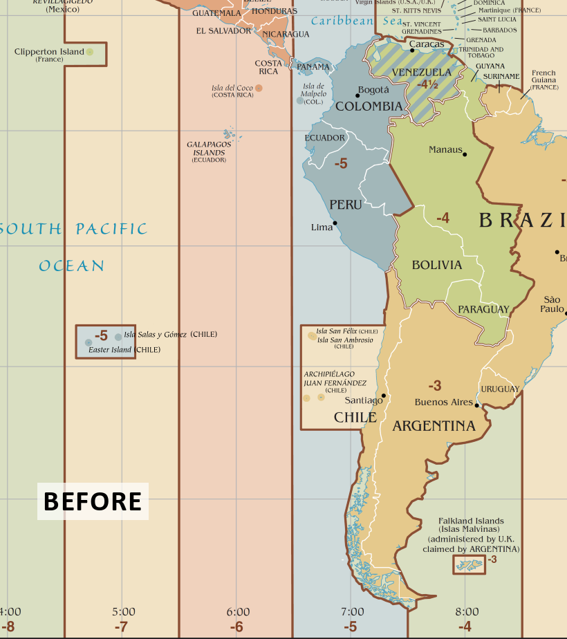
Before and after: Interactive map of time zones that changed during 2016 in South America
Before and After: Tap or hover to see which time zones changed shape in 2016

Finally, Venezuela also changed its clocks in 2016, completely erasing one of the world’s time zones off the map. Since 2007, Venezuela had been the only place in the world using a time zone of UTC -4:30 (which it also used from 1912 to 1965). 

But last April, President Nicolas Maduro announced that the country would set clocks ahead half an hour, returning to the more conventional UTC -4 time zone. The stated purpose was to counter a severe energy shortage. By lengthening evening sunlight hours, it was hoped that the country would save electricity, because people would wait an extra half hour before turning their lights on in the evening. 

Since no other place currently uses the UTC -4:30 zone, Venezuela’s change entirely deleted it from the world time zone map.

Changes to Daylight Saving Time

What the maps in this article don’t show is that many places move temporarily forward an hour in the summer for daylight saving time (DST) – and these policies change just as often as permanent time zones.

In 2016, Tonga reintroduced DST after a period without it, moving its actual time in the summer from UTC +13 temporarily to UTC +14. The UTC +14 time zone, used permanently by parts of the country of Kiribati, is the farthest-forward time zone in the world. Since Tonga is in the southern hemisphere, where summer runs from December to March, this means Tonga and Kiribati together became the first countries to enter the year 2017 on January 1. Curiously, clocks in the UTC +14 time zone show the exact same time as clocks in the UTC -10 time zone (used by Hawaii and French Polynesia), but the date is exactly one day later.

Egypt’s government also planned to reintroduce DST in 2016, after abolishing it twice in the past. But the time changes are so unpopular in Egypt that the government was pressured into canceling the move just a day before some said it would have gone into effect. Meanwhile, Azerbaijan also continued a series of flip-flops on whether to use DST, canceling it in 2016 just 10 days before clocks were set to change. Haiti did the same.

The British Caribbean territory of the Cayman Islands also canceled plans to start using DST in 2016, and the government of the disputed Palestinian territories delayed DST by a week, bringing it closer in line with the dates used by Israel.

What Time Zones Will Change in 2017?

Although an academic proposal to abolish all the world’s time zones is unlikely to happen anytime soon, there are plenty of proposed time zone changes that might come about in 2017. Countries like Namibia, Jordan, Spain, and Hungary are considering changing their time zones, while the European Union, several US states, and at least one Canadian province might abolish daylight saving time (Mongolia has already decided to get rid of DST in 2017, while Haiti has already reversed its 2016 DST cancellation).

Several US states are also debating proposals to switch time zones, either by making DST permanent or by just moving both standard time and DST. One of them, the far northwestern state of Alaska, could merge both its UTC -9 and UTC -10 time zones into the UTC -8 Pacific Time. The change would effectively shift the remote Aleutian Islands two hours forward.

Stay tuned to PolGeoNow’s Twitter feed for updates as we learn about them!

Learn More!
Country and Border Changes in 2016
Rebel Control Around the World in 2016
All PolGeoNow Articles About Time Zones
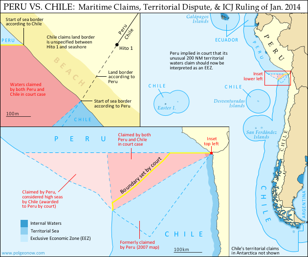
Map: Peru & Chile’s Sea Dispute Settled in Court

Two weeks ago, the International Court of Justice released a long-awaited ruling on Peru and Chile’s disputed maritime boundary. Many headlines claimed that Peru “won” the case, but in fact it was not a full victory for either country. Below is our detailed map of Peru and Chile’s seas and of the dispute, followed by an easy-to-understand summary of the case. 

Map of Chile and Peru's territorial waters and exclusive economic zones (EEZ), plus the details of their territorial dispute at sea and disagreement of the land border. Shows the results of the Jan. 27, 2014 ruling by the International Court of Justice (ICJ) settling the dispute.
Map by Evan Centanni (country coastlines and land borders from Natural Earth)

Premium members click here to view this article in the ad-free members area. Not a member yet? Subscribe now!

Article by Evan Centanni


Disputed Territory
Chile and Peru have just settled a decades-long dispute over the location of their maritime boundary (the border between their sea zones). A large wedge of sea off the countries’ coast was claimed by both sides, in part because of its high value for the fishing industry. In 2008, Peru took Chile to court over the dispute. Their disagreements would be resolved by the International Court of Justice (ICJ), a United Nations body in the Hague founded for the purpose of settling differences between U.N. member countries.

Peruvian and Chilean Waters
The international Law of the Sea entitles every coastal state to extend its territory out to 12 nautical miles (NM) from the shore, making these “territorial waters” fully part of the country but requiring that foreign ship traffic be allowed to pass through. The law also allows the country to regulate economic activity out to a distance of 200 NM, within what is called an “exclusive economic zone” (EEZ). Lakes, rivers, and bays (as well as coastal areas hemmed in by islands) are known as “internal waters,” where the country has absolute authority just like on its land territory.

Flag of PeruCountry Name:  
• Peru (English)
• Perú (Spanish)
• Piruw (Quechua, Aymara)
Official Name:  
• Republic of Peru (English)
• República del Perú (Spanish)
• Piruw Ripuwlika (Quechua)
• Piruw Suyu (Aymara)
Capital: Lima

As a country with an unusually long coastline and possession of several offshore islands, Chile has a long strip of territorial waters and a huge EEZ. But Peru is a bit of a special case: it never ratified the U.N. Convention on the Law of the Sea (UNCLOS), and instead of an EEZ proper, it claims something called a “maritime domain” out to a distance of 200 NM.

Because the Peruvian constitution claims “sovereignty” over this domain, it has always been interpreted as equivalent to other countries’ 12 NM territorial waters. However, during the court case against Chile, Peru’s government declared that its declaration of the maritime domain “is applied in a manner consistent with the maritime zones” in the UNCLOS.* This implies that Peru’s “maritime domain” is now to be considered equivalent to an EEZ rather than to territorial waters, thus curtailing any potential accusations of clearly excessive territorial claims by Peru.

*Source: ICJ judgement, p.61

The Dispute
Since the dispute began some decades ago, Chile claimed that the boundary between the two countries extended due west from the end of the land border. To Chile this meant that it could it extend its own EEZ out to 200 NM directly west from its northernmost coast, but also that the line would keep going from there, cutting off any part of Peru’s maritime domain that might wrap around the outside of Chile’s (the Chilean government noted that Chile itself had made a similar concession on its sea border with Argentina). This is not one of the recommended ways of drawing a boundary under the UNCLOS, but that would all be moot if, as Chile claimed, the two countries had already agreed to it by treaty.

Peru felt differently. It argued that the treaties cited by Chile never explicitly specified a border, and that it therefore was still entitled to negotiate one from scratch. Because Peru’s coast is oriented at an angle to Chile’s, drawing a straight line west would give Chile quite a bit of sea that was actually closer to Peru. So in an official government map from 2007, Peru instead showed the boundary running southwest at an angle of more than 50 degrees from Chile’s line.

In court however, Peru made a more modest claim, choosing an “equidistant line” as recommended in the UNCLOS. This meant carefully calculating a path for which every point would be exactly the same distance from the closest parts of the respective Peruvian and Chilean coasts. The result was a not-quite-straight line running southwest at an angle of about 30 degrees from Chile’s border claim. The area between these two lines would become the officially defined disputed zone. Another large area west of this chunk was within 200 NM of Peru’s coast, but beyond 200 NM from Chile. This zone was claimed by Peru but considered by Chile to be neutral “high seas” (a.k.a. international waters).

But where do the lines start?
In fact, Chile and Peru were not even able to agree on exactly where the maritime boundary should start. The land border between the two countries had been agreed upon in the 1929 Treaty of Lima, and precisely marked on the ground with actual physical pillars. However, the last of the pillars was not right on the shore. Known as Hito 1 (Spanish for “Marker 1”), it was placed on dry land a bit inward from the beach, to ensure that it wouldn’t be washed away.

Peru argued that the border continued, in principle, in a slight curve southwest from Hito 1, following the same circular arc that was used to place the last several border pillars. The treaty apparently wasn’t drafted with this extreme degree of accuracy in mind, and was worded in a way that suggested Hito 1 and the shoreline were the same thing. Chile used this to argue that the sea boundary should be measured along a line drawn from the pillar itself (but not starting until the line reached the seashore), and not from a point to the southwest as Peru claimed. This was taken by many to mean that Chile claimed a land border continuing west from the pillar, but in court Chile’s lawyers argued that there simply was no legally defined land boundary beyond Hito 1.

Flag of ChileCountry Name:  
• Chile (English, Spanish)
Official Name:  
• Republic of Chile (English)
• República de Chile (Spanish)
Capital: Santiago

The Judgement
After years of waiting and over a year of deliberation, the court finally released its ruling on January 27, 2014. Media headlines declared the judgement a “win” for Peru, but in fact it was a complex compromise arrived at through a step-by-step examination of each country’s claims.

The Starting Point and Land Border
The court first needed to decide where the maritime boundary should start. Although Peru argued that it was impossible for a land border to just end without reaching the coastline, the court found that before the dispute began, the two countries had consistently used Hito 1 to define where their respective waters met. This was a small win for Chile, meaning that the maritime boundaary must indeed be drawn from the marker itself rather than from the end of an arc as claimed by Peru.

However, defining the land border itself was not on the court’s agenda, so the disagreement over its course technically remains standing. The court noted that the land border does not necessarily have to end at the same place the sea border begins, meaning that Peru’s claimed land border extension could still be valid even now that it’s irrelevant to the course of the sea boundary.

The Course of the Sea Border
To examine the history of Peru and Chile’s claims, the court examined a series of declarations and treaties published by the two countries in the 1940s and 1950s. It found that both countries had indeed declared jurisdiction out to 200 NM, but that they initially didn’t have any particular border in mind. Instead, their early declarations were intended to protect their waters from foreign whaling and other exploitation, not from each other.

With each treaty they increasingly implied that there was a border running straight west from the coast, but never seemed to say it explicitly. It seemed that perhaps an informal agreement had been made and never put on paper. However, the last treaty referred clearly enough to a straight-west boundary that the court decided it was a done deal. The maritime boundary between Chile and Peru would be line running straight west from Hito 1 – a win for Chile.

But wait – it wasn’t as simple as that. Although the court agreed that Chile and Peru had fixed their straight-west border by treaty, it argued that they had never intended for it to run all the way out to 200 NM or beyond. The agreements referring to the border were only concerned with defining where local fishing boats were allowed to cast their nets, and back then these small boats wouldn’t have ventured out past about 80 NM. The court’s decision, then, was that the boundary should run straight west only to a point 80 NM from the shore – beyond that, there was no line legally agreed upon by treaty.

Beyond 80 NM, the court ruled that Peru indeed had the right to a boundary calculated from an equidistant line out to the farthest point within 200 NM of both countries’ coasts. But since this line started from the end of the 80 NM straight-west line, it ended up quite a bit farther north from Peru’s claimed boundary, giving Chile nearly half of the disputed zone. However, it was still seen as a substantial victory for Peru, since Chile had been seen as controlling the entire zone up until then.

The court also ruled that Peru was indeed entitled to any area of sea within 200 NM of its own coast but beyond 200 NM from Chile. This means that the area previously considered high seas by Chile will indeed become part of Peru’s maritime domain, and even after drawing the equidistant line, a bit of this zone still wraps around the outside of Chile’s EEZ, adding one more segment to the maritime boundary between the two countries.

Dispute Resolved
Though the course of the land border may remain a small sticking point, the sea dispute between Peru and Chile has now been settled (that is, unless the countries argue over the exact coordinates of the line, which were not explicitly named by the court). The ICJ’s ruling is binding, and both Chile and Peru have agreed to respect the court’s decision. Peru’s president Ollanta Humala said he was “pleased” with the ruling, and that he would act quickly to ensure its implementation. President Michelle Bachelet of Chile, on the other hand, called it a “painfull loss,” even while promising to “gradually” implement it.

Full Text: ICJ Judgement of 27 January 2014 – Maritime Dispute (Peru v. Chile)

Related: Map of the Falkland Islands’ Disputed Seas (Argentina vs. U.K.)

Graphics of the Peruvian flag (source) and the Chilean flag (source) are in the public domain.