Syrian Civil War Control Map: October 2015 (Subscription)

There are newer versions of this map available. To see them, view all Syria updates.

Map of fighting and territorial control in Syria's Civil War (Free Syrian Army rebels, Kurdish YPG, Al-Nusra Front, Islamic State (ISIS/ISIL), and others), updated for late October 2015. Highlights recent locations of conflict and territorial control changes, such as Kweires airbase, Kafr Nabudah, Aleppo area, Hama province towns, and more.

Subscribe for full access to all conflict map reports!

Download PDF:
Buy now

Research by Djordje Djukic, with additional reporting by Evan Centanni

A month into Russia’s military intervention in Syria, the Assad government and Iranian troops have made a number of small advances against both the rebels and the so-called “Islamic State” (formerly ISIS/ISIL).

See all this and more on the newest update to PolGeoNow’s concise, professional-quality Syrian Civil War control map, which includes a timeline of changes since our previous Syria map report last month.

This map and report are professional subscriber content, available to paid members or for separate purchase. Download PDF (US$24.99)

Want to see before you buy? Check out our most recent FREE SAMPLE Syria map!

Exclusive map report includes:

  • Up-to-date map of current territorial control in Syria, color-coded for the Assad government, rebel groups, “Islamic State” (ISIS/ISIL) extremists, and Kurdish YPG forces. Special symbol indicates rebel-held towns dominated by Al Qaeda affiliate Jabhat al-Nusra (the Nusra Front).
  • Detailed indication of city-by-city control, highlighting key towns and other locations important to current events.
  • Locations of recent fighting and military operations, including Kweires airbase, Kafr Nabudah, the southern Aleppo countryside, northern Hama province, and more.
  • Detailed timeline of important events and changes to territorial control since September 14, 2015, compiled by our Syria-Iraq expert, with links to sources.

MEMBERS CLICK HERE TO PROCEED TO ARTICLE AND MAP

Not a member yet? Click here to learn more about our professional subscription service!

Map of Boko Haram/”Islamic State” Control in Nigeria: October 2015

(To see other maps in this series, view all Boko Haram updates on PolGeoNow.)
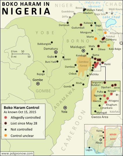
Detailed map of Boko Haram (Islamic State West Africa Province) territorial control in its war with Nigeria, marking each town reportedly under the group's control. Includes key recent locations, including Dikwa, Banki, the Sambisa Forest, and targeted areas on Lake Chad and the borders of Cameroon and Niger.
Map by Evan Centanni. All rights reserved.

(Subscribers click here to view this article in the member area) 

By Evan Centanni

The “Islamic State” in Nigeria
Northeastern Nigeria’s Boko Haram rebels, despite being pushed out of most of the territory they held last year, are still a major force in the region.

After becoming an official affiliate of Iraq and Syria’s so-called “Islamic State” (IS, a.k.a ISIS/ISIL) last March, they have now taken to calling themselves the Islamic State’s West Africa Province (ISWAP).

Status of Territorial Control
The goal of IS is to capture and hold territory, and Boko Haram still hangs on by a thread in that respect. Though the extent of their control has been blurry over the past six months (there is extremely little independent reporting from the region), military forces of Nigeria and neighboring countries have continued to announce the “recapture” of towns – an implicit acknowledgment that territory continues to be hotly contested.

Since this summer, the Nigerian government has stepped up aerial attacks against Boko Haram hideouts in the Sambisa Forest, but the result seems to have been a flood of fighters into nearby communities on border with Cameroon, while the forest remains an area of murky control.
Flag of NigeriaCountry Name:  
• Nigeria (English)*
Official Name:  
• Federal Republic of Nigeria (English)*
Capital: Abuja
*There are hundreds of local and regional languages in Nigeria, but only English has official status.

Chronology of Events
The following is a timeline of major events and changes to territorial control in northeastern Nigeria and neighboring countries since our previous update of May 28, 2015.

Note that Boko Haram launches deadly attacks on an almost daily basis across northeastern Nigeria, frequently on Cameroon’s side of the border, and occasionally in Niger and Chad as well. This timeline focuses on changes of territorial control, adding in selected items representing the biggest news and most significant cross-border incidents.

2015.06.14 Boko Haram fighters sacked the town of Babbangida, north of Yobe state capital Damataru.

2015.06.15 Boko Haram carried out a bombing with heavy casualties in N’Djamena, the capital city of Chad. An important Boko Haram leader would be captured in the city two weeks later.

2015.06.17-23 A deadly Boko Haram attack on Gueskérou, Niger was answered with a five-day long air and ground campaign by that country’s armed forces.

2015.07.01-02 Boko Haram killed almost 200 people in two days, in a wave of attacks across Borno state. As of last March, Boko Haram considers itself the West African branch of the Syria- and Iraq-based “Islamic State” (a.k.a. ISIS/ISIL). The July violence in Nigeria, targeted at non-extremist Muslims, coincided with an IS directive to increase attacks during the Muslim holy month of Ramadan.

2015.07.22 A village in the Hile-Alifa area of Cameroon was reportedly occupied by Boko Haram, two days after a brutal rebel attack on the nearby town of Kamouna.

2015.07.24 The Nigerian army said it recaptured Dikwa from Boko Haram, though the town had already been reported secured by Chadian forces in March.

2015.07.25 Boko Haram attacked the island of Médi Koura among the fragmented remains of Lake Chad, well within the borders of Chad itself. The attack would be followed by major military campaign and heavy fighting in nearby areas, as Chadian troops attempted to drive Boko Haram forces entirely out of the lake region.

2015.08.02 The Nigerian army said it rescued 178 prisoners from Boko Haram, most of them children and women. The 200 missing girls infamously kidnapped from Chibok in 2014 were not among them.

2015.08.21 An army source reported that troops had driven Boko Haram fighters out of Gudumbali.

2015.09.01 Nigerian government forces captured Gamboru-Ngala from Boko Haram. The twin towns had been secured by Chadian forces months earlier, but not protected from subsequent rebel incursions.

2015.09 In early September, Boko Haram fighters began attacking communities on the border with Cameroon after being flushed out of the Sambisa Forest by a heavy government bombing campaign. The attacks included the storming of a market in downtown Kirawa, a town known to have been under Boko Haram control in the past.

2015.09.19 A military spokesman said Nigerian troops had captured Jerre and Dipchari, on the road to Banki.

2015.09.20 A Nigerian newspaper reported that Boko Haram was operating a checkpoint on the road between Gwoza and Limankara, killing any travelers who did not have food to offer to the rebels.

Map of Boko Haram control in Nigeria in March 2015, and the multinational offensive with Cameroon, Chad, and Niger that drove the rebels back.
Multinational offensive against Boko Haram, Jan. to Mar. 2015

2015.09.22 Nigerian troops cleared Boko Haram fighters from camps in Jangurori and Bulatori, near Bama. In the process a high-level Boko Haram leader was captured.

2015.09.24 The Nigerian military said it seized Banki, on the border of Cameroon, with cooperation from the Cameroonian military. The next day, “at least 200” Boko Haram fighters allegedly surrendered to the government forces.

2015.09.23-25 Madagali, at the northern tip of Adamawa state, was reportedly abandoned by its population after three consecutive days of Boko Haram raids.

2015.10.07 The military claimed that over 100 Boko Haram fighters were killed in a failed attack on troops in Goniri, on the Borno-Yobe state line.

2014.10.08 An open letter from displaced residents to President Buhari said Boko Haram was in control of a number of villages east of Gwoza, including Ngoshe, Attagara, Kirawa, and Kughum.

2014.10.10 Dozens were killed in a Boko Haram attack on a fish market in Baga Sola, on Chad’s side of the border.

2015.10.14 The US announced it was sending 300 troops to Cameroon to assist in tracking down Boko Haram fighters.

Following this story? View all Boko Haram maps on PolGeoNow!

Timeline compiled with the help of the ACLED dataset (Raleigh, Clionadh, Andrew Linke, Håvard Hegre and Joakim Karlsen. 2010. Introducing ACLED-Armed Conflict Location and Event Data. Journal of Peace Research 47(5) 651-660.)

Graphic of the Nigerian flag is in the public domain (source).

African Union Suspends Burkina Faso, Then Reinstates it Again (Map)

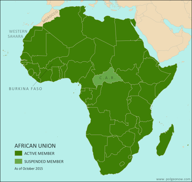
Map of the African Union, including active and suspended member countries, updated for the September 2015 suspension and reinstatement of Burkina Faso (colorblind accessible).
Map by Evan Centanni, from this blank map by Eric Gaba. License: CC BY-SA

Premium members click here to view this article in the ad-free members area. Not a member yet? Subscribe now!

Article by Evan Centanni

Coup Crisis
On September 18, Burkina Faso was suspended from the African Union (AU) by the organization’s Peace and Security Council. The action was in response to a government takeover by soldiers loyal to the country’s former president Blaise Compaore, who was pushed out in a popular uprising a year ago.

A military coup usually gets a country automatically suspended and sanctioned by the Peace and Security Council, which aims to promote constitutional rule in all AU member countries. (This pro-democracy policy has no affect on dictatorships that are already long-established.)

Resolution & Reinstatement
In a quick resolution to the crisis, Burkina Faso’s coup was over just a week after it started; the internationally-supported president was released from custody, and the coup leader stepped down apologetically after popular protests and mediation by neighboring countries. The AU Peace and Security Council, which is always in session, responded by lifting Burkina Faso’s suspension on September 26.

After Burkina Faso’s return to active membership, there is only one remaining suspended AU member: the Central African Republic (CAR). The CAR was suspended in March 2013 after a rebel takeover, followed by the installation of a weak compromise government. Planned elections probably would have gotten the CAR reinstated to the AU later this month, but they’ve been delayed after a new outbreak of violence.

Flag of the African Union (AU)Organization Name:  
• African Union (English)
• al-Āthḥād al-’Āfrīqī (Arabic)
• Union africaine (French)
• União Africana (Portuguese)
• Unión Africana (Spanish)
• Umoja wa Afrika (Swahili)
Launched: 2002 in Durban, South Africa
Headquarters: Addis Ababa, Ethiopia
Website: www.au.int

What is the African Union?
Formed launched in 2002 as a replacement for the earlier Organization of African Unity (OAU), the AU is an intergovernmental organization that works on increasing cooperation, stability, and development within the continent of Africa. The organization is headquartered in Addis Ababa, Ethiopia. (Ethiopia is the only African country that the European empires were never able to colonize, and is also the second most populous country in Africa.)

Compared to the neighboring European Union (EU), the AU is only a loose forum for cooperation between its member countries. AU members do not have an integrated economic system, union-wide laws, or shared foreign policy, though further integration is a possibility for the future.

The African Union includes every UN-recognized country in Africa except for Morocco. Morocco withdrew from the OAU in 1984, after the organization chose to admit the Sahrawi Arab Democratic Republic (SADR), a disputed country that claims ownership of the mostly Moroccan-controlled Western Sahara territory. The only other parts of Africa not represented in the AU are a few groups of offshore islands controlled by European countries, as well the small Spanish enclaves in North Africa. The breakaway Republic of Somaliland is not a member, but is considered by the AU to be part of member-state Somalia.

Low-resolution graphic of the African Union flag is displayed under fair use principles (source).