Syria Civil War Map: June 2013 (#10)

There are newer versions of this map available. To see them, view all Syria updates.

Since March, large-scale violence has continued in Syria. Despite this, no major cities have changed hands – yet there have been important changes to control of smaller towns in two different regions. Here’s the updated conflict map, plus a summary of recent territorial changes.
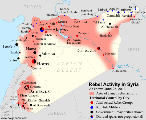
Map of rebel activity and control in Syria's Civil War (Free Syrian Army, Kurdish groups, Al-Nusra Front and others), updated for June 2013. Includes recent locations of conflict and violence, including the Qusayr, Golan Heights, Daraa, Dael, and Baida.
Activity and cities held by rebels and other groups in Syria, updated for June 2013. Map by Evan Centanni, starting from this blank map by German Wikipedia user NordNordWest. License: CC BY-SA

Golan Heights Fighting
Soon after our last update, rebel groups continued making small gains in Syria’s far southeast. In mid-March, they captured a military intelligence compound in the town of Shagara, and three days later the same group seized the town of Khan Arnabeh a bit to the north. Both towns lie close to the Golan Heights, a disputed territory controlled by Israel.

A narrow strip of land on the Syrian side of the Golan Heights ceasefire line has been demilitarized under the protection of U.N. peacekeepers since 1973, but even this area has seen fighting since late last year. Rebels in the zone briefly took control of the border crossing with Israel early this month, part of a series of events that has put the peacekeeping mission’s future in jeopardy.

Rebel Gains in Daraa
Soon after taking Khan Arnabeh, the same rebel group achieved yet another major victory: the capture of a major air defense base just east of the southern Syrian city of Daraa. Soon they and other rebel groups had effective control of all border crossings with Jordan.

By the end of the month, rebel forces were also in control of Dael, an important town north of Daraa city. It was only in May that the Syrian army began getting its foothold back outside of Daraa, seizing the town of Khirbet Gazaleh near Dael.

Flag of Syria under the current governmentCountry Name:  
• Syria (English)
• Sūriyya/Sūryā (Arabic)
Official Name:  
• Syrian Arab Republic (English)
• al-Jumhūriyyah al-‘Arabīyah  as-Sūriyyah (Arabic)
Capital: Damascus

Government Takes Qusayr
The more important change in control came early this month, when the Syrian government and allied forces captured Qusayr after a long and difficult battle. Qusayr is a strategic town between the city of Homs and the border with Lebanon, and saw prolonged fighting earlier in the war before coming under rebel control a year ago. Since Qusayr’s recapture, other nearby towns have also been seized by the government.

Hezbollah and Lebanon
In the battle for Qusayr, Syria’s army received major military support from Hezbollah, a Shiite militia from Lebanon which has long supported President Bashar al-Assad. After that victory, Hezbollah has become more overtly involved in the fighting within Syria. Meanwhile, Lebanon is being slowly dragged into its neighbor’s civil war, with one Lebanese town even coming under attack from the Syrian military two weeks ago.

Battles Continue in Major Cities
Syria’s biggest population centers continue to be centers of intense fighting as well, with Aleppo still divided between multiple groups (see a collaborative map of control) and once-rebel-dominated Homs now reportedly 80% government-controlled. At the same time, the capital city of Damascus continues to see heavy back and forth fighting in its suburbs, and in recent months rebels have even begun moving into the city itself.

Activity on the Coast
Last month, the town of Bayda near Syria’s Mediterranean coast became infamous for a brutal massacre committed by government or allied forces against Sunni civilians, some of whom had been rebel sympathizers (rebels were also accused of a sectarian massacre in a few weeks later). The Bayda massacre was reportedly a response to an attack by local rebels on a bus carrying pro-government militiamen, a rare and possibly unprecedented instance of armed rebel activity Syria’s coastal region. This area, which is the traditional homeland of President Assad’s minority Alawite sect, has been so far spared from rebel-on-army fighting, though it has been the scene of unarmed protests violently suppressed by the government.

Adjustments to the Map
Two adjustments have been made to the Syria control map in this update which do not necessarily reflect actual changes to the situation since last time. First, the city of Hama has been colored all black rather than black and red, to reflect the fact that there has recently been little evidence of significant rebel control within the city (however, back-and-forth fighting continues outside the city in Hama province).

The second adjustment is to Zabadani, in the mountains between Damascus and the border with Lebanon. This town has been contested since early in the war, sometimes falling under rebel control and other times to the government. The most recent information suggests that rebels have nearly complete control of the town itself, despite being surrounded by government forces.

Related Articles:

Graphic of the Syrian flag is in the public domain (source).
Disputed Territory: The Senkaku/Diaoyu Islands

You may have heard the news about China and Japan’s ongoing territorial dispute over a group of islands in the East China Sea. But what are the Senkaku/Diaoyu Islands, and why are they so fiercely contested? Read on for all these answers and more!

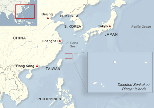
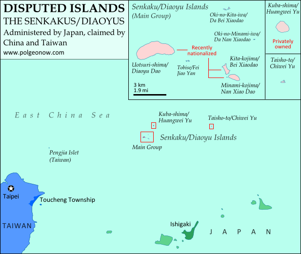
Map of the Senkaku/Diaoyu Islands, disputed between Japan, China, and Taiwan; includes location as well as detail of islands
Map of the disputed Senkaku/Diaoyu Islands (by Evan Centanni).

Article by Omar Alkhalili

About the Islands
The Senkaku/Diaoyu Islands are a collection of five small islets and three rocks in the East China Sea, all of which are uninhabited. The largest of the islands has an area of 4.32 km² and the smallest is only 0.45 km². They are located about 140 km from the nearest inhabited Japanese islands, 300 km from mainland China and 170 km from Taiwan. They are administered by Japan but claimed by both the People’s Republic of China (PRC) and Taiwan, whose government is known officially as the Republic of China (ROC).

Map of the location of the disputed Senkaku/Diaoyu Islands within Asia
Location of the disputed Senkaku/Diaoyu Islands in Asia
Public domain graphic (source)

In English, the islets have historically been referred to as the Pinnacle Islands, but are now more often called by their Japanese and Chinese names. In Japan, they are known as the Senkaku Islands, whereas in mainland China they are called the Diaoyu Islands and in Taiwan they are referred to as the Diaoyutai (Tiaoyutai) Islands. They are administered by Japan as part of Ishigaki, a municipality in Okinawa Prefecture, while the PRC and ROC both consider them part of Toucheng township in Taiwan’s Yilan County, despite the fact that the two rival governments do not recognize each other.

While it considers the islands part of Ishigaki, Japan’s central government does not allow the city to develop or survey them. Four of the islands have been privately owned since 1932, but the government bought three of them last year after renting them for some time. One of the privately owned islands is still leased to the Japanese Ministry of Defense, which has allowed the United States military to use it as a practice bombing range for aircraft.

History of Claims and Control

Territory Name:  
Senkaku-shotō (Japanese)
• Diàoyúdǎo (Mandarin – China)
• Diàoyútái (Mandarin – Taiwan)
Pinnacle Islands (English – historical) 
Claimants: 
• Japan
• China (People’s Republic of China)
• Taiwan (Republic of China)
Actual Control: Japan
Administrative Status: Part of the country
Capital: N/A (uninhabited)

Japan, mainland China and Taiwan all root their claims to the Senkakus/Diaoyus in the region’s history. China was aware of the islands’ existence since the 15th century, and the PRC and ROC claim that the islands have been part of Chinese territory since at least the 16th century. However, the Japanese government holds that when it surveyed the islands in the late 1800s, they were uninhabited and showed no signs of having been under Chinese administration.

Japan took control of the islands in 1895, and with the exception of the American occupation of Japan from 1945 to 1972, has held onto them ever since. Both Chinas now consider the islands to be part of Taiwan province, which China ceded to Japan in 1895 after the First Sino-Japanese War. However, they hold that Japan returned the rights to the islands to China by surrendering to the Allied Powers at the end of World War II. Japan insists that these islands were not part of the territory that it gave up in surrendering, arguing that they were always considered part of the Ryukyu island chain rather than Taiwan. China and Taiwan did not voice their claim to the Senkaku/Diaoyu islands until after the U.S. occupation Okinawa ended in 1972.

On top of the historical claims, various economic issues complicate the dispute. The islands’ territorial waters include rich fishing grounds and lie along the path of strategically important shipping lanes. Potential oil reserves have also been identified nearby.

Current Dispute
In recent years, tensions over the Senkaku/Diaoyu Islands have flared between Japan and both Chinese governments. After a series of incidents in 1996 that included Japanese activists installing a light house on one of the islands and the death of a Chinese activist due to drowning, there have been continued instances of Chinese activists attempting to sail to the islands, resulting in their arrest and detention.

Aerial view of two of the Senkaku/Diaoyu Islands disputed between Japan, China, and Taiwan
Aerial photo of Kita-kojima/Bei Xiaodao and Minami-kojima/Nan Xiaodao in the Senkaku/Diaoyu Islands
(Courtesy of Japan National Land Image Information (Color Aerial Photographs, Ministry of Land, Infrastructure, Transport and Tourism; source)

In 2010, an incident involving the detention of a Chinese ship crew precipitated mass protests in Chinese cities. Two years later, before the Japanese government’s purchase of three of the islands, the then Governor of Tokyo came up with his own plan to buy the islands, sparking protests in China and resulting in the detention of a group of activists from Hong Kong. Mainland China has challenged Japanese control of the islands through incursions into their territorial waters and airspace. In 2013, the mainland government announced that it plans to survey the islands in order to safeguard its maritime interests.

Recently, some progress has been made in resolving the dispute, with Japan and Taiwan arriving at an agreement allowing Taiwanese fishermen access to a large portion of the island’s surrounding waters. This agreement may create an obstacle for mainland China as its government becomes isolated in its efforts to challenge Japanese control. However, Taiwan still retains its claims to the Senkakus/Diaoyus, and there is no clear end in sight for the dispute between the three governments.

Omar Alkhalili is a contributor to Political Geography Now. He is a graduate of Ramapo College of New Jersey with a Bachelor of Arts Degree in Political Science. He can be reached at omaralkha@gmail.com.

See Also: The Eight Islands of the Senkaku/Diaoyu Group (profiles and aerial photos)

Related Articles:

Niger and Burkina Faso Resolve Territorial Dispute