Yemen Control Map & Report: September 2016 (Subscription)

SUBSCRIBERS CLICK HERE TO PROCEED TO ARTICLE AND MAP

There are newer versions of this map available. To see them, view all Yemen updates.

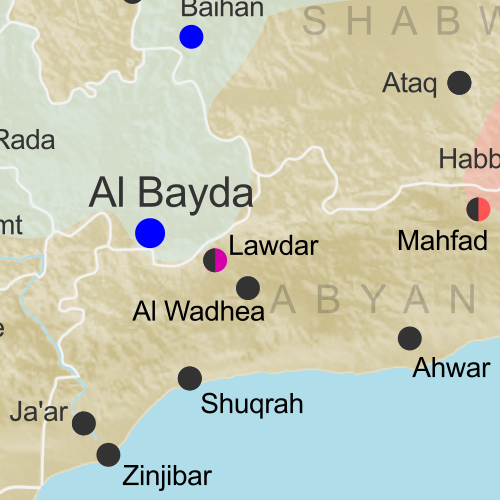
Map of territorial control in Yemen as of September 23, 2016, including territory held by the Houthi rebels and former president Saleh's forces, president-in-exile Hadi and his allies in the Saudi-led coalition and Southern Movement, Al Qaeda in the Arabian Peninsula (AQAP), and the so-called Islamic State (ISIS/ISIL). Includes recent locations of fighting, such as Taiz, Jaar, Zinjibar, Ahwar, and more.

Subscribe for full access to all conflict map reports!

Timeline by Djordje Djukic. Map by Louis Martin-Vézian, Evan Centanni, and Djordje Djukic.

Since our last Yemen control map update almost two months ago, Al Qaeda has lost a large part of its territory in Yemen, even as fighting continues between the Houthis and the Saudi-backed Hadi government.


See all this and more on the newest update to PolGeoNow’s Yemen territorial control map, which includes a timeline of changes and important events since our previous Yemen map report in early August.

This map and report are premium professional content, available to paid subscribers of the PolGeoNow Conflict Mapping Service.

Want to see before you buy? Check out our most recent FREE SAMPLE Yemen map report!

Exclusive report includes:

  • Up-to-date map of current territorial control in Yemen, color-coded for the pro-Hadi coalition, Houthi/Saleh forces, Al Qaeda in the Arabian Peninsula (AQAP), and the so-called “Islamic State” (ISIS/ISIL).
  • Color scheme now consistent with Syria, Iraq, and Libya map series
  • Detailed indication of town-by-town control, including provincial boundaries, all major cities, and many smaller ones
  • Markers for recent areas of fighting, including Taiz, Jaar, Zinjibar, Ahwar, and more
  • Timeline of changes to the situation since August 2, 2016, with links to sources

SUBSCRIBERS CLICK HERE TO PROCEED TO ARTICLE AND MAP

Not a member yet? Click here to learn more about our professional subscription service!

Can I purchase just this map?
This map and report are not available for automated purchase to non-subscribers. If you need access or republication rights for only this map report, contact service@polgeonow.com for options.

The Fall of Libya’s “Islamic State”: Sept. 2016 Control Map & Timeline (Subscription)

SUBSCRIBERS CLICK HERE TO PROCEED TO ARTICLE AND MAP

This is the second of a pair of Libya map reports, the first one chronicling the major political realignment that occurred in Libya between March and May of 2016. 

There are newer versions of this map available. To see them, view all Libya updates.

Research by Djordje Djukic. Map by onestopmap.com and Evan Centanni

Subscribe for full access to all conflict map reports!

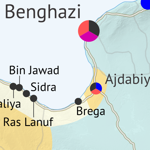
Libya control map: Shows detailed territorial control in Libya's civil war as of September 2016, including all major parties (Government of National Accord (GNA), Tobruk House of Representatives, General Haftar's Libyan National Army, Zintan militias, Petroleum Facilities Guard (PFG); Tripoli GNC government, Libya Dawn, and Libya Shield Force; Shura Council of Benghazi Revolutionaries and other hardline Islamist groups; and the so-called Islamic State (ISIS/ISIL)). Also file under: Map of Islamic State (ISIS or ISIL) control in Libya. Now includes terrain and major roads. Color blind accessible. The past four months have seen a drastic reduction in “Islamic State” (ISIS/ISIL) control in Libya, with the group now barely holding any territory in the country. Meanwhile, the struggle continues between Libya’s two rival governments, as well as other religious hardline militias.
 
See all this and more on the latest update to PolGeoNow’s concise, professional Libyan Civil War control map, which comes with a timeline of changes since our May 2016 Libya map report.

This map and report are premium professional content, available to paid subscribers of the PolGeoNow Conflict Mapping Service.

Want to see before you subscribe? Check out our most recent FREE SAMPLE Libya map!

Exclusive report includes:

  • Up-to-date map of current territorial control in Libya, color-coded for the UN-backed Government of National Accord (GNA), the rival Tobruk parliament (supported by General Haftar’s Libyan National Army), “Islamic State” (ISIS/ISIL) fighters, and other religious hardline groups. 
  • Detailed indication of city-by-city control, including key towns and other locations important to current events.
  • Locations of recent fighting and military operations, including Sirte, Ajdabiya, Abu Grain, Bin Jawad, Harawa, and more.
  • Detailed timeline of important events and changes to territorial control since May 10, 2016, with all sources cited.
  • New since last year: Major roads are marked on the map for reference

SUBSCRIBERS CLICK HERE TO PROCEED TO ARTICLE AND MAP

Not signed up yet? Click here to learn more about our professional subscription service!

Can I purchase just this map?
This map and report are not available for automated purchase to non-subscribers. If you need access or republication rights for only this map report, contact service@polgeonow.com for options.

Libya’s Political Realignment: May 2016 Control Map & Timeline

This is the first of a pair of Libya map reports, with the second spotlighting the retreat of “Islamic State” forces from May to September. The second report, with a more up-to-date map, is available to members of our conflict map subscription service. 

There are newer versions of this map available. To see them, view all Libya updates.

Libya control map: Shows detailed territorial control in Libya's civil war as of May 2016, reflecting the political realignment after UN peace deal, including all major parties (Government of National Accord (GNA), Tobruk House of Representatives, General Haftar's Libyan National Army, Zintan militias, Petroleum Facilities Guard (PFG); Tripoli GNC government, Libya Dawn, and Libya Shield Force; Shura Council of Benghazi Revolutionaries and other hardline Islamist groups; and the so-called Islamic State (ISIS/ISIL)). Also file under: Map of Islamic State (ISIS or ISIL) control in Libya. Now includes terrain and major roads. Color blind accessible.
Base map by Koen Adams of onestopmap.com, with territorial control by Evan Centanni. All rights reserved.

(Subscribers click here to view this article in the member area)

Timeline by Djordje Djukic, with additional reporting by Evan Centanni

Drastic Political Shift
Starting soon after our last Libya control map report in March, the structure of Libya’s divided control and rival governments underwent a massive realignment, with international recognition essentially switching from one side of the country to the other, and some key fighting forces switching sides as well.

Last year, the country was already divided between two rival governments, the controversial General National Congress (GNC) in the capital city of Tripoli and the more internationally-recognized House of Representatives in the eastern city of Tobruk (with forces of the so-called “Islamic State”, formerly ISIS/ISIL, holding territory in between).

In an effort to unite the two governments, a UN-backed peace deal created a new “Government of National Accord” (GNA), which last March dramatically sailed into Tripoli from Tunisia to take over the reigns. Within a few weeks, the old GNC government had yielded to GNA authority, and most of the GNC-associated Libya Dawn militias agreed to support the new government too (at least for the time being). However, the GNA failed to secure an endorsement from the legislature in Tobruk, limiting the new government’s power in the east to support from the maverick Petroleum Facilities Guard (PFG) along the central coast.

The result is that most international recognition has shifted to the new Tripoli government, whose military is largely made up of the same forces that were loyal to the controversial GNC, while Tobruk’s formerly recognized government and army are now the defiant rivals.

For the full history of the current civil war since the fall of dictator Muammar Gaddafi in 2011, including the origins of the country’s competing governments, see our detailed Libya background article and timeline from August 2015.
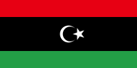
Flag of Libya (2011-present)Country Name:  
• Libya (English)
• Lībyā (Arabic)
Official Name:  
• State of Libya (English)
Dawlat Lībyā (Arabic) 
Capital: Tripoli

Timeline of Events
The following is a detailed timeline of major political events and changes to territorial control since our previous Libya control map of March 2016.

March 16-17, 2016
The European Union agreed on sanctions against three Libyan officials – including the president of the Tripoli-based General National Congress (GNC) – who were opposed to the new UN-backed unity government, the Government of National Accord (GNA). The designated prime minister of the GNA said he expected to move to Tripoli from the neighboring country of Tunisia within days.

March 31, 2016
The dissolution of the GNC government started, with its officials, under pressure from former allies, leaving Tripoli and going back to their home cities. Members of the Presidential Council of the GNA sailed into Tripoli the same day. Subsequently, 10 cities formerly under the control of the GNC pledged their support for the GNA. Following this, GNA support continued to spread further in the west and south of the country, while in the east support for the GNA remained uncertain.

However, the Petroleum Facilities Guard (PFG) under Ibrahim Jathran, in control of eastern oil ports including Sidra, Ras Lanuf, and Brega, did pledge its allegiance to the GNA.

April 5-6, 2016
The GNC-affiliated “National Salvation Government” in Tripoli disbanded and ceded authority to the Presidential Council. The next day, the State Supreme Council elected its president and first deputy. By this time, GNA Prime Minister Fayez al-Serraj was in control of Libya’s central bank and national oil company as well.

Read More: Foreign Policy magazine tells the story of the GNA’s whirlwind rise to power

April 17-19, 2016
The Tobruk-loyal “Libyan National Army” (LNA) organization captured the University of Benghazi, the Al-Hawari cement factory and two nearby cemeteries from religious hardline militias in Benghazi, as well as the Al-Quwarsha area of Benghazi’s district.

April 20, 2016
Forces of the so-called “Islamic State” (IS, formerly ISIS/ISIL) withdrew from positions on the outskirts of Derna, cementing the control of the Mujahideen Shura Council (MSC), a rival religious hardline group, over the town. The LNA also claimed to have taken control of IS’s abandoned positions.

Map of the territorial control (Assad government, Islamic State/ISIS/ISIL, rebel, SDF, and Kurdish) in the Syrian Civil War as of April 2016
Map of IS Control in Syria, April 2016
(click for free article and map)

April 27, 2016
IS ambushed a convoy reportedly consisting of GNA fighters and British and Italian soldiers. The attack reportedly left some Italian marines dead or wounded.

April 29, 2016
As of the end of April, the Tobruk-based House of Representatives, the previous internationally-recognised Libyan parliament, had not yet given its support to the new GNA government in Tripoli. Major sticking points were Tripoli’s disdain for LNA star general Khalifa Haftar, as well as a procedural requirement for the GNA government to present itself in person before the House (meanwhile, GNA leaders were still holed up in an old navy base in Tripoli despite the proclaimed support of many militias in the city).

Also by late April, the GNA had gained the loyalty of several important government ministries.

May 5, 2016
As GNA forces were preparing an offensive to recapture Sirte from IS forces, IS launched a pre-emptive attack. In the offensive, IS claimed to have captured several villages, including Abu Grain, Baghla, and Abu Najaym.

May 10, 2016
A military faction in the eastern city of Ajdabiya declared that it did not support the Tobruk-based LNA.

Timeline continued in subscriber article:
The Fall of Libya’s “Islamic State”: Sept. 2016 Control Map & Timeline

Graphic of the Libyan flag is in the public domain (source).

Iraq Control Map & Report: September 2016

There are newer versions of this map available. To see them, view all Iraq updates.

Detailed map of territorial control in Iraq as of September 5, 2016, including territory held by the so-called Islamic State (ISIS, ISIL), the Baghdad government, and the Kurdistan Peshmerga. Includes results of recent fighting around Qaiyarah (Qayyarah) south of Mosul. Color blind accessible.
Basemap by Koen Adams of onestopmap.com, with territorial control by Evan Centanni and Djordje Djukic. All rights reserved.

(Subscribers click here to view this article in the member area.)

Research and timeline by Djordje Djukic

Summary of Recent Events
After recapturing Ramadi from the so-called “Islamic State” (IS; formerly ISIS/ISIL), the Iraqi government and allies have set their sights on Mosul, the largest IS-controlled city, and until a few years ago the second largest city in Iraq (some sources say half or more of its population fled after the IS takeover in 2014). Since our last Iraq control map report at the end of June, the main change to territorial control has been the government capture of Qaiyarah, a town south of Mosul that’s still more or less surrounded by IS and Kurdish controlled ground.

See Also: Syrian Civil War Control Map: August 2016

Flag of IraqCountry Name:  
• Iraq (English, Kurdish)
• al-‘Irāq (Arabic)
Official Name:  
• Republic of Iraq (English)
• Jumhūriyyat al-‘Irāq (Arabic)
Komara Iraqê (Kurdish)
Capital: Baghdad

Timeline of Changes in Territorial Control
The following is an outline of major events since PolGeoNow’s previous Iraq map update of June 30, 2016. The abbreviation “IS” refers to the organization calling itself “the Islamic State”, also known as ISIS or ISIL. The Peshmerga is the military of Iraqi Kurdistan.

June 29-July 12, 2016
Two weeks after the military started an advance towards the Qaiyarah airbase, they took control of a village 45 kilometers from the airfield on June 29. Subsequently, on July 9, the Iraqi army captured the Qaiyarah airbase, 60 kilometers south of Mosul. Three days later, the same forces linked up with government troops which had been advancing from Makhmour since March, after they captured a village on the Tigris riverbank north of Qaiyarah.

July 3, 2016
Reports said 292 people were killed by a suicide bomber detonating an explosive-filled minibus in the Karrada district of Baghdad.

July 7, 2016
IS suicide bombers attacked a Shiite shrine in a town between Samarra and Baquba, leaving 56 people dead and more than 70 wounded. The attackers fought their way through a market before reaching the gates of the Sayyid Muhammad bin Ali al-Hadi mausoleum, where they blew themselves up.

July 9, 2016
Iraqi security forces captured two villages north of Ramadi from IS.

July 18, 2016
The Iraqi Army launched an assault on the town of Qaiyarah. Meanwhile, Iraqi security forces captured a town in the western part of Anbar province.

August 2, 2016
Iraqi security forces seized two areas south of Mosul, in the area of Qaiyarah.

August 7, 2016
IS suicide bombers attacked a village 60 kilometers south of Mosul, killing 11 people, including six soldiers.

August 14-16, 2016
Kurdish forces took control of 12 villages near Mosul. During the advances, Kurdish Peshmerga forces reached a bridge connecting Erbil, Mosul, and Kirkuk. The Kurds managed to reach the western side of the bridge, thus securing a crossing over the Grand Zab river. The crossing over the river would make it possible for Kurdish forces to eventually advance on Mosul from a new front. Meanwhile, Iraqi security forces captured four villages in the Qaiyarah area.

August 23-25, 2016
Iraqi government forces attacked the center of Qaiyarah, fully capturing the town two days later. They claimed about 250 IS fighters were killed in the battle.

August 29, 2016
Five IS attackers, including a suicide bomber, killed 15 people at a wedding in a town west of Karbala (south of Baghdad, far outside of the IS control zone).

August 30, 2016
It was revealed that before retreating from the Qaiyarah airbase, IS had almost completely destroyed the facility. This was seen as possibly hindering any future attempt by Iraqi forces to retake Mosul, since the air base was intended to be used as a staging area for any future operations against the city.

August 31, 2016
Human Rights Watch accused Sunni pro-government militias of recruiting children into their ranks.

Graphic of the Iraqi flag is in the public domain (source).