Syrian Uprising: Map Update 3

There are newer versions of this map available. To see them, view all Syria updates.

Country Name: Syria (English), Sūriyya/Sūryā (Arabic)
Official Name: Syrian Arab Republic (English),
al-Jumhūriyyah al-‘Arabīyah as-Sūriyyah (Arabic)
News Category: Divided Countries
Full Story: See Syria Divided by Armed Conflict

Map of Syria, showing control by the rebel Free Syrian Army as of April 10, 2012
Known areas of armed activity for the rebel “Free Syrian Army”, marking controlled cities and notable towns.
Many rural areas may also be under full rebel control. Unarmed protests not shown. Map is my own work,
starting from this blank map by German Wikipedia user NordNordWest. License: CC BY-SA

Syria Conflict Update
In the three weeks since our last Syria update, the Syrian military has continued its campaign to retake the northern province of Idlib from the rebel Free Syrian Army (FSA). Having retaken Idlib city earlier in the month, the government forces then targeted the province’s second largest city, recapturing Saraqib (Saraqeb) after a four-day battle ending on March 28. In an offensive which is still ongoing despite plans for a U.N.-brokered ceasefire, the Syrian military has also overrun a number of previously rebel-held towns and villages in the Idlib area, most recently taking the town of Taftanaz in an especially bloody battle this week.

Meanwhile, a new front has opened up in the north of Aleppo province, where according to some reports the rebels have controlled the city of Azaz and other towns since early March. In central Syria, the battle continues for the city of Homs, of which the FSA still controls some northern areas. The historical site of Qalaat al-Madiq (Madiq Castle) in Hama province also made news at the end of last month, as the Syrian army stormed the town after a two week siege (government-friendly media later reported that the town had been completely captured).

Useful Link: Wikipedia – Timeline of the 2011-2012 Syrian Uprising

Declaration of Independence of Azawad (English Translation)

Country Name: Azawad (English, Tuareg, French), Azawād (Arabic)
News Categories: New Countries, Breakaway States, Unrecognized States
Full Story: New Country: Azawad Declares Independence from Mali

Flag of Azawad (image by Orionist; source)

Presented here is the full text of the Declaration of Independence of Azawad, originally posted in French to the website of the National Movement for the Liberation of Azawad (MNLA) on April 6, 2012, and translated into English by Evan Centanni of Political Geography Now. The MNLA is a Tuareg-led rebel group which has recently achieved control of the northern part of Mali in West Africa. For a history of the 2012 Tuareg rebellion in Mali, view all Mali posts on Political Geography Now.

Original Document: Declaration of Independence of Azawad (French)

**********************

DECLARATION OF INDEPENDENCE OF AZAWAD
[Unofficial translation by Political Geography Now]
WE, THE PEOPLE OF AZAWAD,
By the voice of the National Movement for the Liberation of Azawad after consultation with:
  • The Executive Committee,
  • The Revolutionary Council,
  • The Advisory Council,
  • The Staff of the Liberation Army,
  • The regional bureaus
Recalling the principles of international law and the principle international legal instruments governing the right of peoples to self-determination, particularly Articles 1 and 55 of the United Nations Charter, and the relevant provisions of the international Declaration of the Rights of Indigenous Peoples;
Considering the will expressed explicitly in the letter dated 30 May, 1958, addressed to the French president by the notables, spiritual leaders of all constituent parts of AZAWAD;
Considering that in 1960, on the occasion of the granting of independence to West African peoples, France attached AZAWAD without its consent to the Malian state that France had just created;
Recalling the massacres, the atrocities and abasement, the plundering and genocide of 1963, 1990, 2006, 2010 and 2012, which targeted exclusively the people of AZAWAD up until 1 April 2012;
Recalling the inhumane conduct of Mali, which utilized the various droughts (1967, 1973, 1984, 2010, etc.) to eradicate our people by devastation even as it sought and obtained generous humanitarian support;
Considering the accumulation of more than 50 years of bad governance, of corruption and of military-political-financial collusion, threatening the existence of the people of AZAWAD and imperiling regional stability and international peace;
Considering the complete liberation of the territory of AZAWAD;
Proclaim irrevocably the INDEPENDENT STATE of AZAWAD starting from this day, Friday, 6 April, 2012.

WE DECLARE:
  • Recognition of existing borders with neighboring states, and their inviolability;
  • Full adherence to the UN Charter;
  • The firm commitment of the MNLA to create conditions for lasting peace, to introduce the institutional foundations of the state based on a democratic constitution for independent Azawad.
The Executive Committee of the MNLA invites the entire international community in a spirit of justice and peace to recognize without delay the independent state of AZAWAD.
The Executive Committee of the MNLA, until the establishment of the Authority of the Territory of AZAWAD, will continue to manage the entirety of the territory.


GAO – 2012/04/06

SECRETARY-GENERAL – MNLA

BILLAL AG ACHERIF

New Country: Azawad Declares Independence From Mali

Country Name: Azawad (English, Tuareg, French), Azawād (Arabic)
News Categories: New Countries, Breakaway States, Unrecognized States
Summary: Tuareg-led rebels in northern Mali have declared “the independent state of Azawad”, after taking control of all of the region’s major cities and military bases and advancing to near the edge of their claimed territory. Azawad is not recognized as an independent country by any U.N. members, making it an example of a so-called “breakaway state”.

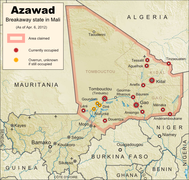
Map of the new independent state of Azawad, declared by MNLA Tuareg rebels in northern Mali. Shows claimed territory and towns controlled by the rebels group as of April 6, 2012
Map of State of Azawad, declared by the Tuareg-majority MNLA rebel group in Mali. Modified from Wikimedia map by Orionist, incorporating images by Carport and NordNordWest (source). License: CC BY-SA.

See Also: Mali Divided by Separatist Fighting; all Mali map updates

MNLA Claims Independent Azawad
The National Movement for the Liberation of Azawad (MNLA) today declared independence from Mali via a statement in French on its website. The rebels of the MNLA, mostly from the Tuareg ethnic group of the Sahara Desert, claim that the northern region of Mali, which they call Azawad, was wrongly included in that country when it declared its independence from France in 1960. There has not yet been any announcement on what form of government Azawad will have, or on which city will be its capital, but the MNLA says it is committed to democracy, to following the rules of the U.N., and to respecting the borders of other countries in the region.

Full Text: Declaration of Independence of Azawad (English Translation)

Flag of the independent state of Azawad, as claimed by the MNLA Tuareg rebel group in northern Mali
Flag of Azawad (image by Orionist; source)

The breakaway state of Azawad is not yet recognized diplomatically by any of the world’s other countries, and is unlikely to be any time soon. It joins the ranks of the various wholly or partially unrecognized states of the world, including fellow African state Somaliland, which similarly controls its whole territory despite complete lack of recognition from either the U.N. or other states. This status will likely prevent Azawad from appearing on mainstream world maps for some time to come.

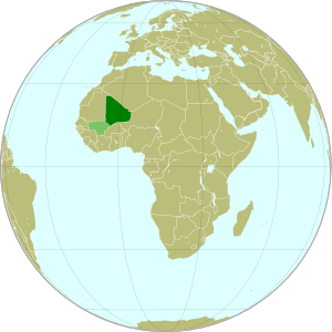
Map showing the location of the new state of Azawad in Africa, declared by the MNLA Tuareg rebel group in northern Mali
Azawad (dark green) and remainder of Mali (light green) in
Africa. Modified from this Wikimedia map (public domain).

Update on Territorial Control
Since our last map update, the Tuareg rebels of the MNLA advanced as far as the town of Douentza (according to their own claims, which have not been disputed), after which they declared a ceasefire, saying they had completed their mission to liberate Azawad. The town of Niafunké has also apparently switched hands a few times over the last few months (source in French), with its current situation unclear. The reality is that the Malian military probably no longer controls anything within the claimed territory of Azawad. Towns not shown as rebel-controlled on the map may simply not be occupied by anyone.

However, the new state of Azawad now faces a threat from another direction – the Islamist Ansar Dine militia, which fought alongside the MNLA over the last few months (with or without their approval). Ansar Dine is now attempting to install strict Sharia (Islamic law) in the cities, in opposition to the MNLA’s claimed desire for a secular state. An additional complication is that Ansar Dine in fact does not support independence for Azawad, believing instead that Sharia law should be instated throughout Mali. Ansar Dine is also a Tuareg-led group.

Seen this Mali conflict map on Wikipedia?
While Political Geography Now sometimes uses free maps from Wikipedia or other sites (after double-checking their sources), we also occasionally post our own maps to Wikipedia and Wikimedia Commons for others to use. The first version of this particular map of the Tuareg-led rebellion in Mali was created for Wikipedia by Orionist, but I have since taken charge of keeping it updated, with a bit of help from Mnmazur on Wikimedia Commons (Mnmazur is not associated with Political Geography Now).

Mali Conflict Map: Separatist Capture Timbuktu and Gao (April 2012)

Country Name: Mali (English, French, Bambara)
Official Name: Republic of Mali (English), République du Mali (French)
News Category: Divided Countries
Summary: Tuareg-led rebels in northern Mali have now completed their control of the region’s major cities, after capturing the military headquarters in Gao as well as historic Timbuktu. Meanwhile, Mali has been suspended from regional organization ECOWAS in response to the recent coup d’etat in the capital, Bamako.

Map of Tuareg rebellion in Northern Mali (Azawad), showing towns controlled by the MNLA rebel group as of April 1, 2012
Towns captured by the Tuareg-majority MNLA rebel group in Mali. Modified from Wikimedia map by Orionist, incorporating images by Carport and NordNordWest (source). License: CC BY-SA.

Full Story: Mali Divided by Separatist Fighting; all Mali map updates

Conflict Update
Again immediately following our last update, northern Mali’s National Movement for the Liberation of Azawad (MNLA), made up mostly of Saharan Tuareg people, has followed its victory in Kidal by capturing the region’s other two major cities. On March 31, the rebels took control of Gao, headquarters of the Malian military in the north, and the next day overran Timbuktu, a historic former trading post and modern tourism destination. The town of Aguelhok in the north is now also being reported as under Tuareg control, though it is unclear when it was recaptured (the rebels had previously taken and lost it again back in January).

The military government of Mali, which took over in a recent coup d’etat, has now withdrawn its forces from most of northern region, known to the Tuareg rebels as Azawad. Neighboring countries have offered military assistance only if the country returns to democracy, and have suspended Mali’s membership in the Economic Community of West African States (ECOWAS) while imposing tough sanctions. If help doesn’t come soon, the MNLA could be in the position to declare independence in the north, making Azawad Africa’s newest country.

Follow events as they develop on Political Geography Now! To see only stories about this ongoing conflict, filter posts using the Mali label.

Seen this map on Wikipedia?
While Political Geography Now sometimes uses free maps from Wikipedia or other sites (after double-checking their sources), we also occasionally post our own maps to Wikipedia and Wikimedia Commons for others to use. The first version of this particular map of the Tuareg-led rebellion in Mali was created for Wikipedia by Orionist, but I have since taken charge of keeping it updated, with a bit of help from Mnmazur on Wikimedia Commons (Mnmazur is not associated with Political Geography Now).