Map of Rebel Control in Mali: June 2015

(To see other maps in this series, view all Mali articles.)

Map of territorial control in Mali as of June 2015. Includes separatist rebel control (CMA, MNLA, MAA, HCUA) and locations of UN peacekeeper (MINUSMA) deployments, as well as the location of a brief takeover by Al Qaeda in the Islamic Maghreb (AQIM).
Map by Evan Centanni, modified from this map by Orionist, Carport, and NordNordWest. License: CC BY-SA.

Subscribers click here to view this article in the ad-free members area. Not a member yet? Subscribe now!

Article by Evan Centanni

Separatist Return to Power
At the time of our last Mali rebel control map report, separatist rebels had just allowed the Malian government to resume control of the north as part of a ceasefire agreement ahead of elections. The rebels had for a time resumed control of the region after a French-led military intervention pushed out the religiously-oriented rebel groups who had usurped the initial separatist rebellion. In July 2013, Mali’s territory was again united for the first time in over a year.

But that was two years ago now. Skirmishes between government and separatist forces continued after the elections, and by summer of 2014, towns began to fall once again under separatist control. The National Movement for the Liberation of Azawad (MNLA) and allied groups once again ruled large parts of Mali’s sparsely-populated extreme north, where they had declared an independent country in April 2012.

Today, the allied separatist forces appear to control much of the region around Kidal, and have proven capable of attacking much farther south in recent months. However, they have gradually backed down from their insistence on full independence, and peace may finally be around the corner. A new agreement offering partially-devolved powers to the north has been signed by the Malian government and two small members of the separatist alliance, with the MNLA and two other major groups saying they too will sign on June 20.
Flag of MaliCountry Name:  
• Mali (English, French, Bambara)
Official Name:  
• Republic of Mali (English)
• République du Mali (French) 
• Mali ka Fasojamana (Bambara)
Capital: Bamako

Timeline of Events
The following is a timeline of major events and changes to territorial control since July 2013.

2013.07.01 A new UN peacekeeping mission, the United Nations Multidimensional Integrated Stabilization Mission in Mali (MINUSMA), officially begins. It replaces an early, more hastily-formed multinational force composed of troops from neighboring countries.

2013.07.28 Mali holds the first round of its presidential elections.

2013.08.02 The results of the first round of elections are announced: candidates Soumaila Cisse and Ibrahim Boubacar Keita will advance to the runoff election.

2013.08.11 The runoff presidential election is held, with Keita declared the new president-elect of Mali.

2013.08-2014.05 Regular clashes continue in northern Mali between separatists, pro-government forces, and others, but no reports emerge of rebels capturing territory.

2014.05.20 The town of N’Tilit is occupied by MNLA separatists (source: ACLED).

2014.05.21 A government attempt to assert greater control over the town of Kidal results in a resounding defeat, with separatists seizing the whole city.

2014.05.22 After the capture of Kidal, the MNLA rebels claim they have also taken over Anefis, Aguelhok, Tessalit, Ménaka, Ansongo, Anderamboukane and Léré, though government officials soon deny this. A BBC correspondent “confirms” that the Malian army has withdrawn from Anefis, Aguelhok, Tessalit, and Ménaka.

Later events will suggest that Ménaka and Anefis were indeed under rebel control, but that Léré was not. The status of the other towns remains unclear (Tessalit and Aguelhok, though inside the separatist-dominated Kidal region, are also home to contingents of foreign troops).

2014.10.16 N’Tilit is taken from the MNLA by fighters of the Self-Defense Group of Imghad Tuareg and Allies (GATIA), a pro-government, Tuareg-majority militia.

2014.10.18 GATIA and allied militias capture Tessit from the MNLA, which had retreated there after its defeat in N’Tilit.

2014.10.28 At a meeting in Anefis, the three largest separatist groups in Mali’s north form a unified military command, called the Coordination of Azawad Movements (CMA). The member groups are the MNLA, the Arab Movement of the Azawad (MAA), and the High Council for the Unity of Azawad (HCUA). The HCUA is a Tuareg-majority group formed largely from former members of Ansar Dine, the group which helped the MNLA take over in 2012, but sought to turn Mali into a religious state until it was defeated during the French intervention. Two smaller groups will later join the CMA as well.

2014.12.26 The MAA, an Arab-majority member group of the CMA, is reported to be in control of Taoudenni, the largest settlement in Mali’s vast northwestern desert.

2015.01.05 Fighters from Al Qaeda in the Islamic Maghreb (AQIM) briefly capture a major Malian military base in the central town of Nampala. AQIM has no direct connection to the separatist rebels, but has benefited from chaos in the north.

2015.02.04 GATIA fighters capture Tabrichat from CMA separatist forces.

2015.04.27 MNLA forces are pushed out of Ménaka by GATIA and a pro-government faction of the MAA.

2015.05.14 After internationally-brokered talks in Algeria, CMA separatists agree in principal to a peace deal with Mali’s government, which would allow more devolution of power to the northern regions. Two smaller members of the CMA sign the agreement, but the MNLA, MAA, and HCUA say they are not yet ready to sign.

More Control Maps:
Map of Territorial Control in Iraq (May 2015)
Map of Boko Haram Control in Nigeria (May 2015)
Syrian Civil War Territorial Control Map (May 2015)

Graphic of Malian flag is in the public domain (source).
Mali Conflict Map: National Territory Reunited Ahead of Elections (July 2013)

There are newer versions of this map available. To see them, view all Mali maps. 

This is an update within our Mali conflict map series – for the original story, see Mali Map: Islamist Control & French Intervention

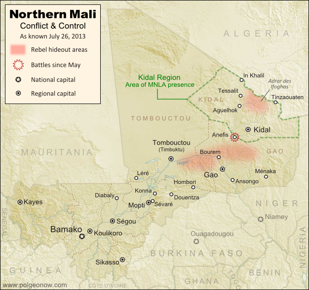
Updated map of fighting and territorial control in Mali during the 2013 French and African intervention against Islamist rebel groups MUJAO, Ansar Dine, and Al Qaeda in the Islamic Maghreb (AQIM). Reflects the situation as of July 27, 2013, including the Kidal region claimed by the Tuareg rebels of the National Movement for the Liberation of Azawad (MNLA).
Updated map of situation in Mali ahead of elections on July 28, 2013. Map by Evan Centanni, modified from Wikimedia map by Orionist, using images by Carport and NordNordWest (source). License: CC BY-SA.

Army Returns to Kidal
As shown on the previous edition of our Mali war map, January’s French intervention against religious extremists returned most of the country to government control, but left the northeastern province of Kidal in the hands of the Tuareg-dominated rebels of the National Movement for the Liberation of Azawad (MNLA). The MNLA had insisted that the Malian army not be allowed into Kidal, citing the army’s alleged abuses against Tuareg and Arab people, leading France to seek negotiations between the MNLA and Mali’s central government.

The Malian government likewise insisted that it be allowed into Kidal prior to national elections on July 28th, and the army at one point appeared poised to fight its way in by force, capturing the provincial border town of Anefis in early June. However, after two more weeks, the government and the MNLA signed a formal deal, agreeing to put off questions of autonomy for the north until after the elections. Under the agreement, Mali’s army was allowed to peacefully enter Kidal, and MNLA soldiers returned to their camps.

Flag of MaliCountry Name:  
• Mali (English, French, Bambara)
Official Name:  
• Republic of Mali (English)
• République du Mali (French) 
• Mali ka Fasojamana (Bambara)
Capital: Bamako

U.N. Peacekeeping Mission Begins
A new U.N. peacekeeping mission in Mali, called MINUSMA, officially began on July 1st. The mission replaces the international African force already in the country, a coalition of West African neighbor countries plus Chad, under U.N. command. In addition to the U.N. peacekeepers, there are also still 3,200 French troops remaining in Mali.

What About the Islamist Rebels?
Religious extremist rebel groups Ansar Dine and the Movement for Unity and Jihad in West Africa (MUJAO), which last year controlled all of northern Mali, have mostly gone into hiding since the French intervention – Ansar Dine in the Adrar des Ifoghas mountains of Kidal, and MUJAO in the area of Gao and nearby stretches of the Niger River. Al Qaeda’s local branch, AQIM, is also present.

Our last Mali war map showed continuing battles against the rebels even in the north’s major cities, but since May the fighting has mostly come to an end, with the militants avoiding rather than confronting the French army’s ongoing expeditions into the desert. The only major fighting reported since our last update was a clash between MUJAO rebels and the MNLA in Anefis, prior to the town being taken by the Malian army.

Related Articles:

Nigeria War Map: Boko Haram Loses Territory

Graphic of Malian flag is in the public domain (source).
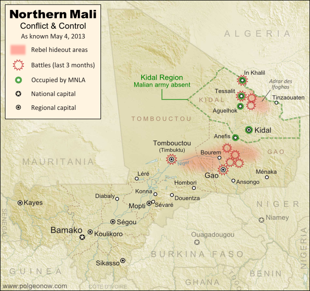
Mali Conflict Map: Hardline Rebels on the Run, Separatists Rebounding (May 2013)

There are newer versions of this map available. To see them, view all Mali maps.  

This is an update within our Mali conflict map series – for the original story, see Mali Map: Islamist Control & French Intervention.

Updated map of fighting and territorial control in Mali during the 2013 French and African intervention against Islamist rebel groups MUJAO, Ansar Dine, and Al Qaeda in the Islamic Maghreb (AQIM). Reflects the situation as of May 4, 2013, including areas occupied by Tuareg rebels of the National Movement for the Liberation of Azawad (MNLA).
Updated map of territorial control and fighting in Mali, as of May 4, 2013. Map by Evan Centanni, modified from Wikimedia map by Orionist, using images by Carport and NordNordWest (source). License: CC BY-SA.

Towns Cleared of Islamist Rebels
Since our last Mali update in February, the country’s religious extremist rebel groups have continued their retreat from the northern cities that they controlled for half a year. The military intervention by France and Mali’s neighbors has somewhat reunited the country, though with some important exceptions.

In Mali’s far northeast, French and Chadian forces have driven Ansar Dine and Al Qaeda in the Islamic Maghreb (AQIM) out of the important towns of Aguelhok and Tessalit, afterwards seeing heavy combat in the nearby mountains of the Adrar des Ifoghas, where Chad claims to have killed two key regional Al Qaeda leaders. Though many rebels are said to have fled the country, some are still holed up deep in the mountains, and have launched terrorist attacks on the regional capital of Kidal.

More information: Regular situation reports from the French army (in French)

Northern Mali’s biggest city, Gao, was secured by French forces early in the intervention, and is now patrolled by troops from Mali and other African countries. However, the Al Qaeda-offshoot rebels of the Movement for Unity and Jihad in West Africa (MUJAO), who ruled the city for months, have continued their resistance, initiating two major battles in Gao during February, and another in March. Timbuktu has faced similar attacks, which have been variously attributed to either MUJAO or AQIM.

Flag of MaliCountry Name:  
• Mali (English, French, Bambara)
Official Name:  
• Republic of Mali (English)
• République du Mali (French) 
• Mali ka Fasojamana (Bambara)
Capital: Bamako

MUJAO fighters are now based in the villages and countryside surrounding Gao, especially just across the River Niger and in the valleys to the northeast, where French soldiers have been involved in lethal confrontations with the militants. The stretch of the River Niger between Gao and Timbuktu has also seen MUJAO activity, but at least one major town along the route, Bourem, has been secured by the allied forces.

Photos: Mali Conflict Enters New Phase (The Atlantic)

Kidal, Azawad, and the MNLA
The National Movement for the Liberation of Azawad (MNLA), a secular rebel organization made up mostly of people from the Tuareg ethnic group, has sprung back to life in Mali’s far northeast. It now occupies most of the Kidal region, including the capital and key towns, cooperating with the French and Chadian armies but forbidding Malian troops from entering.

The group, which initiated the rebellion in northern Mali last year – declaring an independent country called “Azawad” before being pushed out by Ansar Dine and MUJAO – now seeks again to negotiate with the Malian government. It has ceased its explicit calls for independence, even saying it “recognizes the borders” of Mali, though it has since begun issuing official “Republic of Azawad” documents to drivers passing through Mali’s far northeast.

This second rise of the MNLA was made possible by concerns that Malian soldiers were abusing, and in some cases murdering, Tuareg civilians in the cities they had retaken. Kidal, unlike Gao and Timbuktu, actually has a Tuareg majority, and the MNLA is relatively popular there. After the extremist Ansar Dine rebels fled from Kidal ahead of the French advance, the MNLA welcomed the foreign troops, cooperating with the soldiers from France and Chad. The Malian army, apparently sensing it’s not welcome, has mostly not entered the region.

The MNLA now operates a checkpoint in Anefis, on the border of Kidal and Gao regions, and has defended itself against other rebel groups in the surrounding desert as well as in the town of In Khalil on the border of Mali and Algeria. In February, the MNLA also claimed control of Menaka in Gao region, but the town is now known to be under the control of African troops from neighboring Niger.

Northern Mali: Looking Forward
The future is not at all certain for Mali’s north, with Islamist militants still active and the MNLA calling for greater autonomy against the wishes of the Malian government. Deepening the uncertainty, France and Chad, by far the two strongest armies currently in Mali, are both beginning to withdraw their forces, not wanting to become stuck in an ongoing guerrilla war. However, there’s still hope for Mali not to descend back into chaos; the U.N. security council has authorized a peacekeeping mission to take over starting from July, which will work under the name Multidimensional Integrated Stabilization Mission in Mali (MINUSMA).

Related Articles:

Central African Republic: Map of Rebel Advance to Capital

Graphic of Malian flag is in the public domain (source).
Mali Conflict Map: French Take Kidal, Other Towns (February 2013)

There are newer versions of this map available. To see them, view all Mali maps.  

This is an update of our Mali conflict map – for the original story, see Mali Map: Islamist Control & French Intervention.

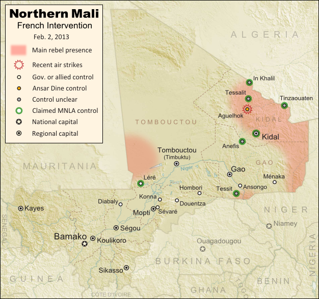
Updated map of fighting and territorial control in Mali during the January-February 2013 French intervention against the Islamist extremist rebel groups Ansar Dine and MUJAO. Reflects the situation as of February 2, when Kidal and other towns have been captured by French and African forces.
Updated map of territorial control and airstrikes in Mali, as of Feb. 2, 2013. Map by Evan Centanni, modified from Wikimedia map by Orionist, using images by Carport and NordNordWest (source). License: CC BY-SA.

French Troops Secure Kidal
After taking the two largest cities in Mali’s north over the last week, the French military by Thursday had also secured Kidal, the last of the area’s three major regional centers. The religious extremist rebels of Ansar Dine had apparently already fled the city, which was instead occupied by two moderate rebel organizations, the MIA and the MNLA, the latter of which originally took over the north last spring before being driven out by religious extremist groups.

The MNLA rebels, who were originally a Tuareg-led separatist movement (and even declared an independent country in their territory), have reemerged since the French intervention began, with an apparent willingness to negotiate for limited autonomy within Mali. If fact, they did not resist the French takeover of Kidal, saying they only refuse occupation by the Malian army itself, which they claim has long abused the Tuareg and Arab people of the far north. They also claimed control of a number of towns in the region this week, though journalists have not been able to verify these assertions.

Flag of MaliCountry Name:  
• Mali (English, French, Bambara)
Official Name:  
• Republic of Mali (English)
• République du Mali (French) 
• Mali ka Fasojamana (Bambara)
Capital: Bamako

Meanwhile, two other major towns near Gao have also fallen out of rebel hands. Ansongo was taken on Tuesday by forces from Niger and Mali, while Ménaka was occupied by allied soldiers from Chad. The Chadian contingent makes up nearly half of the African foreign supporting force in Mali, and unlike the others is not a member of the West African regional bloc ECOWAS.

With the capture of all three major northern cities, and reports that most of the Niger River region has also been secured, the first phase of the intervention in Mali is coming to an end. The victorious French and Malian presidents made a celebratory visit to Timbuktu on Saturday, declaring that French soldiers would remain in the country only long enough for African forces to take over the peacekeeping mission.

The extremist rebels have apparently fled into the desert, with Ansar Dine (or what’s left of it after its split with the MIA) believed to be hiding out in the mountains north of Kidal. The only town known to be under their control is Aguelhok, which was targeted by French airstrikes in recent days.

Besides the shrinking strongholds of Ansar Dine, several border areas appear to be under the influence of the MNLA rebels, though as mentioned before, they have not opposed the foreign intervention so far. MUJAO, the other major extremist group which had controlled towns in northern Mali, is apparently nowhere to be seen (for the moment anyway).

Original Story: Mali Map: Islamist Control & French Intervention

Further Reading: 
Islamists’ Harsh Rule Awakened Ethnic Tensions in Timbuktu
Niger agrees to host Mali-bound U.S. spy drones
Reuters Slideshow – Timbuktu Retaken

Additional Source for Map: France24 map – War in Northern Mali

Graphic of Malian flag is in the public domain (source).
Mali Conflict Map: Gao and Timbuktu Retaken (January 2013)

There are newer versions of this map available. To see them, view all Mali maps.   

This is an update of our Mali conflict map – for the original story, see Mali Map: Islamist Control & French Intervention.

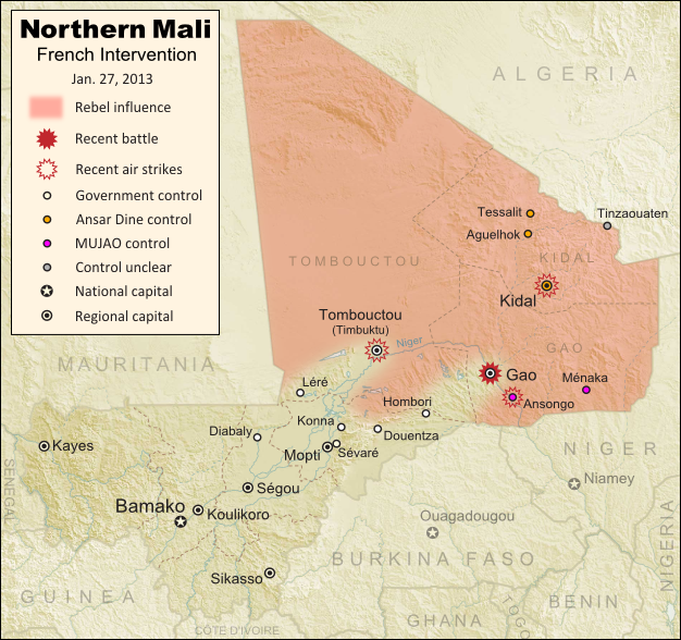
Updated map of fighting and territorial control in Mali during the January 2013 French intervention against the Islamist forces of Ansar Dine and MUJAO. Reflects the Jan. 26-27 recapture of major northern cities Gao and Timbuktu by French and Malian forces.
Updated map of territorial control and fighting in Mali, as of Jan. 27, 2013. Map by Evan Centanni, modified from Wikimedia map by Orionist, using images by Carport and NordNordWest (source). License: CC BY-SA.

French-Malian troops capture two major northern cities
Events have proceeded quickly in Mali’s ongoing war since the France’s military intervention against radical Islamist rebels began just over two weeks ago. This weekend, French and Malian troops recaptured Gao and Timbuktu, two of the three major towns seized by separatist rebels last spring and taken over by radical right-wing militias a few months later.

After taking back most of the country’s central region earlier this week (See: Mali Map Update 2: Douentza Secured by Government), the allied French-Malian forces proceeded northeast from Diabaly and Douentza. On Friday, they took the town of Hombori on the road to Gao, even as Al Qaeda linked MUJAO rebels destroyed a bridge near the border with Niger in order to obstruct a looming invasion by Nigerien and Chadian troops.

Flag of MaliCountry Name:  
• Mali (English, French, Bambara)
Official Name:  
• Republic of Mali (English)
• République du Mali (French) 
• Mali ka Fasojamana (Bambara)
Capital: Bamako

On Saturday, the French and Malian armies seized Gao itself, where they seem to have encountered a limited amount of resistance from the rebels of MUJAO. Many of the militants had already fled the major cities after weeks of French airstrikes against their positions, and on Sunday the allied troops swept quickly through Léré and all the way to Timbuktu, where they are reportedly now establishing control.

Also in the past week, a major faction of the rebel group Ansar Dine defected, forming a new organization called the Islamic Movement for the Azawad. The new faction, dominated by Malian Tuareg people, claims to renounce Islamic extremism, instead saying they want to negotiate peacefully for increased autonomy in the country’s north.

Meanwhile, the French and Malian armies are receiving increasing support from other countries. The U.S., though not directly involved in the conflict, has been providing logistical support to the French military. And several days ago, troops from the neighboring country of Burkina Faso became the first foreign African forces to be deployed alongside the Malian and French contingents (though they still aren’t on the front lines).

On a darker note, accusations have spread of ethnically-motivated murders of Tuareg and Arab civilians by the Malian military (the northern rebels are mostly Tuareg and Arab people). This comes amid the mysterious barring of foreign journalists from towns occupied by the Malian and French forces. Officials have denied any knowledge of such killings, but human rights organizations have been increasingly raising alarms over the alleged abuse.

Original Story: Mali Map: Islamist Control & French Intervention

Recommended Reading: In Mali, Diabaly residents helped repel Islamist militants

Graphic of Malian flag is in the public domain (source).
Mali Conflict Map: Douentza Secured by Government (January 2013)

There are newer versions of this map available. To see them, view all Mali maps.   

This is an update of last week’s Mali conflict map – for the full story, see Mali Map: Islamist Control & French Intervention.

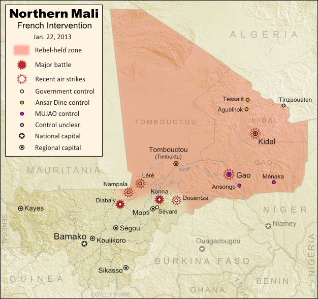
Updated map of fighting and territorial control in Mali during the January 2013 French intervention against the Islamist forces of Ansar Dine and MUJAO. Reflects the Jan. 21 recapture of central town Douentza by French and Malian forces.
Updated map of territorial control and fighting in Mali, as of Jan. 22, 2013. Map by Evan Centanni, modified from Wikimedia map by Orionist, using images by Carport and NordNordWest (source). License: CC BY-SA.

Key Central Town under French-Malian control
The ongoing French-led war against right-wing Islamic insurgents in northern Mali has achieved another victory. Douentza, probably the most important of the central Malian towns formerly held by the rebels, has now been secured by government and French forces. The allied troops reportedly found that the rebels had already left ahead of them, presumably fleeing the French airstrikes that targeted the town over the last week.

Douentza’s status had been a matter of uncertainty for some time, starting with apparently false claims of its capture by the Malian army on the eve of the French intervention. It had been held by the Movement for Unity and Jihad in West Africa (MUJAO), the more extreme of the two main rebel groups controlling territory in northern Mali (and the more closely connected to Al Qaeda).

The capture of Diabaly town has also been fully confirmed now, after a few days of confusion. It had been reported that there was fighting on the ground between French and rebel forces, but residents of the town say it was mainly airstrikes that drove the militants out.

Meanwhile, forces from both France neighboring African countries have continued to arrive in Mali to fight the rebels. French troops in the country now number over 2,000, while African troops from Nigeria, Togo, Benin, Niger, and Chad currently total about 1,000. Chadian and Nigerien troops are also amassing in Niger near the Malian border, from where they may open up a new front by crossing the border to take Gao, the region’s largest city and currently the headquarters of MUJAO.

Original Story: Mali Map: Islamist Control & French Intervention

Recommended Reading: Behind Mali’s conflict: myths, realities & unknowns (commentary from an expert in Mali)

Mali Conflict Map: Hardline Rebels Lose Two Towns (January 2013)

There are newer versions of this map available. To see them, view all Mali maps.   

This is an update of yesterday’s Mali conflict map – for the full story, see Mali Map: Islamist Control & French Intervention.

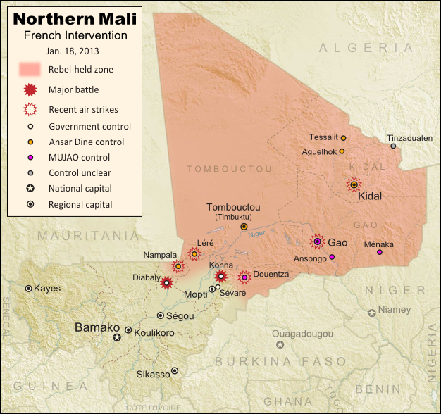
Updated map of fighting and territorial control in Mali during the January 2013 French intervention against the Islamist forces of Ansar Dine and MUJAO. Reflects the Jan. 18 recapture of Konna and Diabaly towns by French and Malian forces.
Updated map of territorial control and fighting in Mali, as of Jan. 18, 2013. Map by Evan Centanni, modified from Wikimedia map by Orionist, using images by Carport and NordNordWest (source). License: CC BY-SA.

Rebels Lose 2 Towns to French-Malian Forces

The French intervention in Mali has finally resulted in territorial gains for the government, after the two central towns of Konna and Diabaly were reportedly retaken by French and Malian troops today. Mali had incorrectly claimed the recapture of Konna earlier this week, and Diabaly was actually seized by the Islamic extremist rebels after French forces arrived. Local sources have now confirmed both towns to be under government control.

Also today, troops from a Nigerian-led West African force finally began arriving in the country (though they have not yet joined in the combat). Meanwhile, a hostage crisis continued into its third day in neighboring Algeria, where militants closely linked to Al Qaeda have taken over a natural gas field and captured its crew of international workers. By some accounts the militants have demanded an end to the French intervention in Mali, though the location of the gas field is far from Mali’s borders, and they are believed to have attacked from within Algeria.

Full Story: Mali Map: Islamist Control & French Intervention

Mali Conflict Map: France Begins Intervention Against Religious Hardline Rebels (January 2013)

There are newer versions of this map available. To see them, view all Mali maps.   

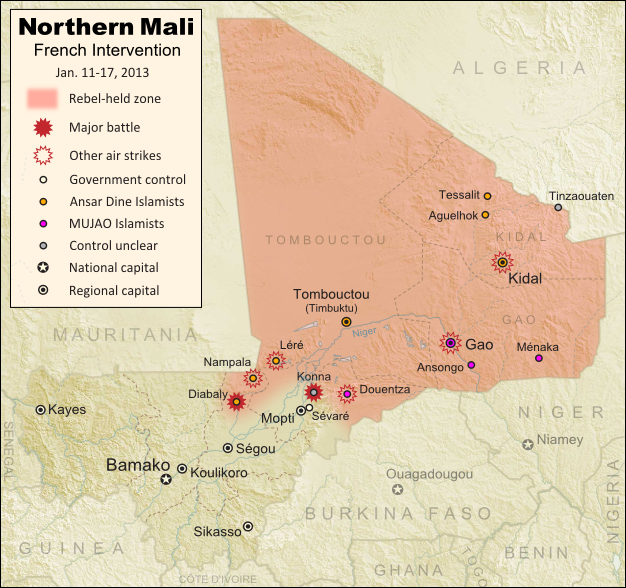
Islamic extremist militants have ruled Mali’s vast northern region almost unopposed for half a year, after driving out the secular Tuareg-majority separatists who briefly declared an independent country there last spring. But everything changed last weekend, with a new rebel offensive and surprise French military intervention that have kicked the war back into full gear. Read on for a summary of events.

Map of fighting and territorial control in Mali during the January 2013 French intervention against the Islamist forces of Ansar Dine and MUJAO
Current territorial control and fighting in Mali (including French intervention). Map by Evan Centanni, modified from Wikimedia map by Orionist, using images by Carport and NordNordWest (source). License: CC BY-SA.

Map Updates: Check our Mali channel for frequent updates to this map.

Northern Mali in Rebel Hands
The rebellion in northern Mali began as a separatist struggle led by the National Movement for the Liberation of Azawad (MNLA), a secular group of mostly Tuareg ethnicity who last spring successfully seized Mali’s north and declared independence as the State of Azawad. But their victory was soon hijacked by Ansar Dine, a hard-line Islamist militia (also led by Tuaregs) that had fought alongside them previously. Ansar Dine was then joined by MUJAO, an Al Qaeda offshoot group, who swiftly expelled the MNLA from the region. (See: Independent Azawad No More: Northern Mali in Islamist Hands)

The closely allied Ansar Dine and MUJAO remained comfortably in control of northern Mali for the next half year. Citizens accused of immorality were brutally punished under an extreme interpretation of Islamic law, and ancient historical sites were destroyed for allegedly being un-Islamic. Meanwhile, Al Qaeda in the Islamic Maghreb (AQIM), the global terror organization’s Northwest African branch, was allowed to operate freely in the region. The U.N. Security Council eventually authorized a military intervention to be led by neighboring countries, but it was not expected to begin until next September at the earliest.

Further Reading: Making Sense of Mali’s Armed Groups (guide to militias from both sides)

Flag of MaliCountry Name:  
• Mali (English, French, Bambara)
Official Name:  
• Republic of Mali (English)
• République du Mali (French) 
• Mali ka Fasojamana (Bambara)
Capital: Bamako

War Breaks Out
Everything changed last week, when Ansar Dine and MUJAO began an allied push to extend their territory southward towards Mali’s capital. On Thursday, the Malian army claimed (incorrectly) to have captured the important town of Douentza from the rebels, but in fact it was soon the Islamists who had taken new territory, the small central town of Konna.

Panic ensued as it appeared Sévaré, which hosts a critical military airport, and Mopti, a regional capital for central Mali, would be next. But the next day, the tables suddenly turned with the surprise arrival of hundreds of French troops (responding to a request from Mali’s president). At the same time, news hit that supporting forces from neighboring West African countries would be arriving within days.

Over the following night, French and Malian forces claimed to have taken Konna back from the rebels, amid a series of airstrikes against Islamist positions. However, by Monday the extremists had captured Diabaly, the nearest town yet to Mali’s capital and major population centers (though perhaps not as significant as it appears); and by Tuesday, the French government was denying that its forces had even recaptured Konna.

The situation in Mali is continuing to change by the hour (Diabaly is now reportedly surrounded by French and Malian troops, and there are unverified claims that Konna has finally been recaptured). Political Geography Now will be releasing frequent updates to the map as the conflict plays out. Stay tuned!

(To see only posts related to this conflict, you can filter the site for all Mali articles).

Note on Names:  
The acronym “MNLA” is based on the French name, and is sometimes rendered “NMLA” to match the English. 
“MUJAO” is also a French-based acronym. The English acronym is “MUJWA” (or sometimes “MOJWA”). 
Ansar Dine is pronounced “an-SAR (uhd)-DEEN” and sometimes spelled “Ansar Eddine” or “Ansar ud-Dine”. 
AQIM is also known by its French acronym “AQMI”; its Arabic actually means “Al Qaeda in the Islamic West”.

Graphic of Malian flag is in the public domain (source).
Independent Azawad No More: Northern Mali in Islamist Hands

There are newer versions of this map available. To see them, view all Mali maps.   

Since declaring the independence of Azawad in April, control by northern Mali’s MNLA rebels has been usurped by the hardline Islamists of Ansar Dine and MUJAO. The new regime, while still bitter enemies of the Malian government, does not claim independence. Presented here is a map and brief guide explaining the current situation.

Map of Islamist rebel control in northern Mali as of September 2012
Area held by Islamist rebel groups Ansar Dine and MUJWA in northern Mali. Map by Evan Centanni, modified from Wikimedia map by Orionist, using images by Carport and NordNordWest (source). License: CC BY-SA.

Separatists vs. Islamists
Last April, the Tuareg-dominated separatists of the National Movement for the Liberation of Azawad (MNLA) swept into victory in northern Mali, completing their control of the region and declaring independence as the State of Azawad. But their victory was won only with the support of Ansar Dine, an Islamist militia led by veteran Tuareg fighter Iyad Ag Ghaly. The MNLA and Ansar Dine then alternated between cooperation and conflict for months, with the Islamists grabbing ever more control of the region’s cities.

Tensions came to a head on June 26, when a second Islamist group, the Movement for Unity and Jihad in West Africa (MUJWA), violently expelled the MNLA from their capital city of Gao. By month’s end, Ansar Dine had fully pushed the MNLA out of key city Timbuktu, and two weeks later the separatists were driven from their last stronghold in the town of Ansongo. Then just this weekend, MUJWA again made news by seizing the town of Douentza from a formerly cooperative local militia.

Flag of MaliCountry Name:  
• Mali (English, French, Bambara)
Official Name:  
• Republic of Mali (English)
• République du Mali (French) 
• Mali ka Fasojamana (Bambara)
Capital: Bamako

Though northern Mali is still not controlled by the national government in Bamako, the Islamist militias do not seek independence. Instead, they pursue a vision of strict sharia law throughout Mali. Since these new rulers no longer consider Azawad a sovereign nation, its claim to independence has faded away.

Current Rebel Control
Ansar Dine and MUJWA together appear to hold all of the territory originally seized by the MNLA, with the line of control lying between the towns of Douentza and Sévaré. Bandiagara in the nearby Dogon region may have an army presence, but other towns such as Koro do not, and have seen rebel raids.

Administration is divided between the two Islamist militias, with Ansar Dine apparently controlling regional capitals Timbuktu and Kidal, and MUJWA controlling at least Gao (also a regional capital) and Douentza. Al Qaeda in the Islamic Maghreb (AQIM), a branch of the terrorist group, also maintains a strong presence in northern Mali. MUJWA is historically associated with AQIM, though Ansar Dine’s relationship to the organization is more tenuous.

Special thanks to Peter Tinti (@petertinti), who has provided invaluable commentary throughout the Mali conflict, and has repeatedly pointed me in the right direction in my research.

Note on Names:  
The acronym “MNLA” is based on the French, and is sometimes rendered “NMLA” to match the English. 
MUJWA is also known as “MOJWA” (from an alternate translation) or “MOJAO” (from the French). 
Ansar Dine is pronounced “an-SAR (uhd)-DEEN” and sometimes spelled “Ansar Eddine” or “Ansar ud-Dine”. 
AQIM is also known by its French acronym “AQMI”; its Arabic actually means “Al Qaeda in the Islamic West”.

Graphic of Malian flag is in the public domain (source).
Declaration of Independence of Azawad (English Translation)

Country Name: Azawad (English, Tuareg, French), Azawād (Arabic)
News Categories: New Countries, Breakaway States, Unrecognized States
Full Story: New Country: Azawad Declares Independence from Mali

Flag of Azawad (image by Orionist; source)

Presented here is the full text of the Declaration of Independence of Azawad, originally posted in French to the website of the National Movement for the Liberation of Azawad (MNLA) on April 6, 2012, and translated into English by Evan Centanni of Political Geography Now. The MNLA is a Tuareg-led rebel group which has recently achieved control of the northern part of Mali in West Africa. For a history of the 2012 Tuareg rebellion in Mali, view all Mali posts on Political Geography Now.

Original Document: Declaration of Independence of Azawad (French)

**********************

DECLARATION OF INDEPENDENCE OF AZAWAD
[Unofficial translation by Political Geography Now]
WE, THE PEOPLE OF AZAWAD,
By the voice of the National Movement for the Liberation of Azawad after consultation with:
  • The Executive Committee,
  • The Revolutionary Council,
  • The Advisory Council,
  • The Staff of the Liberation Army,
  • The regional bureaus
Recalling the principles of international law and the principle international legal instruments governing the right of peoples to self-determination, particularly Articles 1 and 55 of the United Nations Charter, and the relevant provisions of the international Declaration of the Rights of Indigenous Peoples;
Considering the will expressed explicitly in the letter dated 30 May, 1958, addressed to the French president by the notables, spiritual leaders of all constituent parts of AZAWAD;
Considering that in 1960, on the occasion of the granting of independence to West African peoples, France attached AZAWAD without its consent to the Malian state that France had just created;
Recalling the massacres, the atrocities and abasement, the plundering and genocide of 1963, 1990, 2006, 2010 and 2012, which targeted exclusively the people of AZAWAD up until 1 April 2012;
Recalling the inhumane conduct of Mali, which utilized the various droughts (1967, 1973, 1984, 2010, etc.) to eradicate our people by devastation even as it sought and obtained generous humanitarian support;
Considering the accumulation of more than 50 years of bad governance, of corruption and of military-political-financial collusion, threatening the existence of the people of AZAWAD and imperiling regional stability and international peace;
Considering the complete liberation of the territory of AZAWAD;
Proclaim irrevocably the INDEPENDENT STATE of AZAWAD starting from this day, Friday, 6 April, 2012.

WE DECLARE:
  • Recognition of existing borders with neighboring states, and their inviolability;
  • Full adherence to the UN Charter;
  • The firm commitment of the MNLA to create conditions for lasting peace, to introduce the institutional foundations of the state based on a democratic constitution for independent Azawad.
The Executive Committee of the MNLA invites the entire international community in a spirit of justice and peace to recognize without delay the independent state of AZAWAD.
The Executive Committee of the MNLA, until the establishment of the Authority of the Territory of AZAWAD, will continue to manage the entirety of the territory.


GAO – 2012/04/06

SECRETARY-GENERAL – MNLA

BILLAL AG ACHERIF