This is an updated edition of our FIFA member countries article. The original version, from 2014, is here.
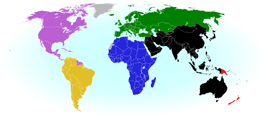 |
| The six continental confederations of national football teams associated with FIFA. Most, but not all, confederation members are individually members of FIFA as well. Map by Evan Centanni, based on work by EOZyo (source). |
Around the world, fans of association football – also known in many countries as “soccer” – are tuning in today for the beginning of the month-long FIFA World Cup in Russia. Not all the world’s countries can advance to the cup, but did they all get a shot at it? Which countries were eligible to enter the tournament, and which are excluded? Read on for our exclusive guide to the roster of FIFA national football teams…
How many FIFA national teams are there?
There are currently 211 national football teams with official FIFA membership, which is required to compete for qualification in the World Cup. FIFA members are divided into six continental confederations that preside over competitions within each region (see map above), though it’s possible to be a member of one of these confederations but not of FIFA.
The confederations are loosely based on the geographical boundaries of the world’s continents, but there are some exceptions: The Asian Football Confederation also includes Australia, Guam, and the Northern Mariana Islands (usually considered part of Oceania), while culturally Caribbean countries, including South America’s Guyana, Suriname, and French Guiana, are grouped with North and Central America. As in the Olympics, Israel is a member of the European confederation despite its location on the Asian continent. Turkey, Kazakhstan, Armenia, Azerbaijan, and Georgia are also grouped with Europe even though each one is technically located mostly in Asia.
FIFA members that aren’t independent countries
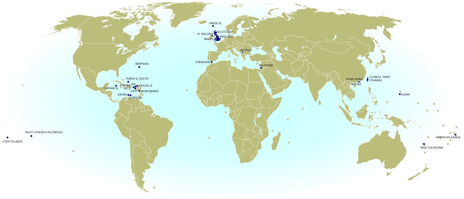
You might have noticed that 211 is more than the number of actual independent countries in the world. After all, the United Nations only recognizes 195. That’s because, much like the Olympics, FIFA used to allow dependent territories to apply for membership. Now it mostly only admits recognized independent countries, but teams that became members in the past are allowed to stay on regardless of their sovereignty status, and exemptions to the rule are possible. Today there are 19 dependent territories with FIFA-eligible national football teams:
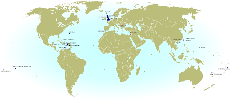 |
| Click to enlarge: FIFA members that aren’t UN member countries, including dependent territories, partially recognized states, and national subdivisions. By Evan Centanni, from public domain base map (source). |
North America & the Caribbean
 Anguilla (UK)
 Aruba (Netherlands)
 Bermuda (UK)
 British Virgin Islands (UK)
 Cayman Islands (UK)
 Curaçao (Netherlands)
 Montserrat (UK)
 Puerto Rico (US)
 Turks & Caicos Islands (UK)
 U.S. Virgin Islands (US)
Asia
 Hong Kong (China)
 Guam (US)
 Macau (China)
Europe
 Faroe Islands (Denmark)
 Gibraltar (UK)
Oceania
 American Samoa (US)
 Cook Islands (New Zealand)
 New Caledonia (France)
 Tahiti (France)
By tradition, each of the four “countries” making up the UK also has a separate team, despite not being independent:
 England
 Northern Ireland
 Scotland
 Wales
Wales
Also as in the Olympics, disputed countries Palestine, Kosovo, and Taiwan (known in international sports as “Chinese Taipei“) are included as special cases without the requirement for fully-recognized independence. In fact, Palestine is now treated as an independent country by the UN, but that wasn’t yet the case when it was first admitted to FIFA in 1998.
New FIFA national teams since 2014
No national teams have left FIFA in the four years since the 2014 World Cup in Brazil, but there are two new ones that have been added.
Europe’s disputed, self-declared Republic of Kosovo was accepted in June 2016, after the FIFA congress decided it had gathered enough recognition from the world’s countries to be considered independent – despite opposition from Serbia, which claims Kosovo as a part of it. Kosovo was also accepted into the Olympics in 2014, but still isn’t treated as an independent country by the United Nations (UN).
At the same time, FIFA also accepted Gibraltar, a British territory in southwestern Europe, as a national team. Since Gibraltar isn’t independent, and its status as a British territory is disputed by Spain, it was rejected from FIFA at first. But in early 2016, a world sports court ruled that its application had to be reconsidered, and within a few months, it was approved.
Which countries aren’t members of FIFA?
As we’ve seen, even some dependent territories are FIFA members – but there are actually a few independent countries that still aren’t:
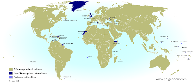 |
| Click to enlarge: FIFA non-members – countries, claimed countries, dependent territories, and any national subdivisions that participate in continental confederations but are not recognized by FIFA. Map by Evan Centanni, from public domain base map (source). |
Europe
 Monaco
 United Kingdom (UK)
 Vatican City
Oceania
 Kiribati
 Marshall Islands
 Micronesia
 Nauru
Nauru
 Palau
Palau
Tuvalu
The Marshall Islands is the only UN-recognized independent country without a national team at all. All the others do have teams (yes, even Vatican City!), but aren’t members of FIFA. That means they’re not eligible even to enter into qualifying matches for the World Cup – though Kiribati and Tuvalu do participate as associate members in the Oceania Football Confederation (OFC), which is associated with FIFA.
And even though Palestine, Taiwan, and Kosovo have managed to secure membership in FIFA, other partially-unrecognized countries haven’t. There are ten non-FIFA teams belonging to unrecognized but independently-governed countries:
 Abkhazia
 Artsakh (Nagorno-Karabakh)
 Donetsk People’s Republic
 Kosovo
 Luhansk People’s Republic
 Northern Cyprus
 Somaliland
 South Ossetia
 Transnistria
 Western Sahara
Transnistria, a self-declared republic in Eastern Europe that’s not recognized by any UN member country, first formed its own national football team in 2015, so it’s been added to the this list since the last World Cup. The less well-established Donetsk and Luhansk People’s Republics, which declared independence from Ukraine in 2014, apparently have their own national teams now as well.
CONIFA, an organization for non-FIFA football, counts almost another 30 “national” teams among its members, many of them representing separatist states or marginalized ethnic groups within FIFA member countries. You can see the full list of those here.
Several other dependent territories and remote islands have their own national teams as well, even if they’re not members of any major confederation. And ten dependent territories and country subdivisions have full or associate membership in the FIFA-connected continental confederations, even though they haven’t been accepted into FIFA itself:
Africa
 Réunion (France)
 Zanzibar (Tanzania)
North America and the Caribbean
 Bonaire (Netherlands)
French Guiana (France)
Guadeloupe (France)
Martinique (France)
Saint-Martin (France)
 Sint Maarten (Netherlands)
Asia
 Northern Mariana Islands (US)
Oceania
 Niue (New Zealand)
Which countries qualified for the 2018 FIFA World Cup in Russia?
Even if a country is an eligible FIFA member, it still has to compete in the pre-tournament qualification process before moving on to the actual World Cup. In the 2018 World Cup, for the first time ever, every single national team in FIFA registered to compete in the qualifiers (209 teams that registered on time, plus new members Kosovo and Gibraltar who were allowed to join later). Besides Kosovo and Gibraltar, Bhutan and South Sudan also tried out for the first time.
Out of the 211 eligible countries, only 32 are allowed to continue into the final World Cup tournament in Russia. Iceland and Panama have both qualified for the first time ever, while four-time champion Italy has gotten locked out for the first time since 1958. Other major players that won’t make it this year include the US, the Netherlands, Cameroon, and Chile. England is the only qualifying team not representing an independent, UN-recognized country (remember, England is just one part of the UK).
Here’s a full map of eligible and qualifying national teams in this year’s World Cup – you can find all the details on Wikipedia.
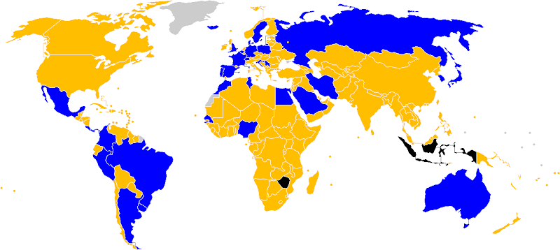 |
| Blue = countries qualifying for the 2018 FIFA World Cup; Orange = countries eliminated in the qualifying rounds; Black = countries expelled before playing any matches; Gray = countries and dependent territories that aren’t FIFA members. Map by 2Nyte and other Wikimedia Commons users (source; CC BY-SA). |
Have something to ask or say about FIFA or non-FIFA countries while you’re watching the World Cup? Tweet to us @PolGeoNow!


 Since late May, fighting between government and rebel forces in Syria has subsided, but battles against the so-called Islamic State (ISIS/ISIL) have continued in both eastern and western parts of the country.