Map: Costa Rica & Nicaragua Settle Border Dispute in Court

Conflicto Isla Portillos - mapa 2018. Map of Costa Rica and Nicaragua's post-2015 territorial dispute on Isla Portillos at the mouth of Rio San Juan, showing the judgment of the International Court of Justic (ICJ) of February 2018, based on the case filed in 2017. Includes key features such as Harbor Head Lagoon, the Nicaraguan military camp, the disputed territory along the beach, and the small water channels used to argue Nicaragua's case. Colorblind accessible.
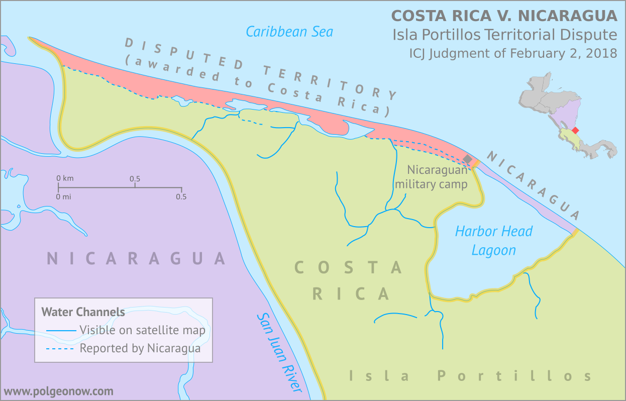
Map by Evan Centanni, based on materials submitted to the court. Contact for usage permissions.

World Court Rules on Costa Rica vs. Nicaragua

What happens when two countries draw their border along a river, then the river changes course? The world got to find out yesterday, as the UN’s International Court of Justice (ICJ) released its judgement on a border dispute between Nicaragua and Costa Rica. Though the court’s ruling was dominated by a related request to define the two countries’ borders at sea, it also involved a tiny sliver of land in a temperamental river delta.

The Isla Portillos Dispute

The disputed land territory involves a slice of coastline at the northern tip of Isla Portillos, an island located in the delta of the River San Juan de Nicaragua (Isla Portillos is sometimes considered part of the larger Calero Island). The border once ran along the river and into a lagoon before hitting the Caribbean Sea, but a hundred years of natural changes to the area’s geography messed that all up.

In this court case – the latest of several between the two countries – Nicaragua claimed that a tiny channel of water still connected the river to the lagoon, separating a narrow strip of Nicaraguan coastline from the island’s Costa Rican interior. But Costa Rica argued that the channel, if it even existed, had been artificially built by Nicaragua, and that the Nicaraguan sandbar that once did exist had long ago eroded away. In this view, a small Nicaraguan military camp on the beach – recently moved from the mouth of the lagoon to a spot slightly farther west – was an illegal occupation of Costa Rican territory.

Flag of Costa Rica (civil)Country Name:  
• Costa Rica (English, Spanish)
Official Name:  
• Republic of Costa Rica (English)
• República de Costa Rica (Spanish)
Capital: San José

Costa Rica admitted that the lagoon itself, and the piece of beach now separating it from the sea, still belonged to Nicaragua, leaving a tiny piece of Nicaraguan territory separated from the rest of the country. Even so, Costa Rica warned that Nicaragua might even lose all of that if the beach erodes away completely (international law doesn’t normally allow a country to claim a body of water without owning some piece of land next to it).

Judgement Day: Who Owns the Beach on Isla Portillos?

When it released its decision this yesterday, the ICJ agreed with Nicaragua that the status of the disputed territory hadn’t already been decided by earlier court rulings. But in the end the judges sided almost entirely with Costa Rica, agreeing that the beach between the lagoon and the mouth of the river are Costa Rican. In a decision made by a vote of fourteen to two, Nicaragua was left with just the lagoon and its short strip of beach, and was ordered to move the military camp off of Costa Rican land.

In an unusual move, the court also decided that the sea just outside of the lagoon would be Costa Rican waters. Normally, any coastline controlled by a country automatically gives it the rights to at least some of the neighboring waters, and denying that to Nicaragua might turn out to be controversial.

The Story of a Border Dispute

The tale of the Isla Portillos dispute goes back almost 200 years, involving a US president, a Confederate general, and a lot of creative geographical analysis.

Costa Rica and Nicaragua declared independence from Spain together in 1821, and went their separate ways after the Federal Republic of Central America fell apart in 1838. But from early on, they scuffled over exactly which land belonged to which country. In 1858, they set out to end the disputes by precisely defining the course of their border in the Cañas–Jerez Treaty of Limits.

That treaty set the right bank of the San Juan River as the border in the Caribbean coastal area, with the boundary ending at a spot called Punta Castilla by the river’s mouth. After bringing in US President Grover Cleveland as a mediator from 1886 to 1888 to settle remaining disputes over the treaty’s validity, plus the exact location of Punta Castilla, the border seemed to be settled once and for all.

>Only one problem: Rivers change course over time. By 1896, when the Costa Rican and Nicaraguan governments set out to actually mark their border with pillars on the ground, the end of the San Juan River had split into three separate channels, hitting the ocean kilometers apart from each other. Naturally, each country chose whichever border interpretation gave it the most land, leaving the intervening islands disputed once again.

Map of the border between Nicaragua and Costa Rica at the Caribbean mouth of the San Juan River as decided by the 1897 Alexander award, including prior claims by each country. Includes Harbor Head Lagoon, the Taura Branch of the San Juan River, and the island now known as Isla Portillos.
Click to enlarge: Map of General Alexander’s 1897 border decision, and the Nicaraguan and Costa Rican claims of the time. The largest island, cut off by the Taura Branch, is Isla Portillos. Public domain illustration (source).

Still, it was no surprise that some disputes would come up in the process of marking out the border, and that’s why they had another third-party mediator on hand.

Grover Cleveland – US president again after a break from 1888-1893 – couldn’t participate in person, so instead he sent his friend Edward Porter Alexander, an engineer and former Confederate general from the US Civil War.

General Alexander decided the border should run as close as possible to the original Punta Castilla spot, now located at the northeastern corner of Harbor Head Lagoon on the San Juan’s middle channel. Realizing the river’s course would keep changing in the future, Alexander specified that the future border should always follow the east side of the lagoon and then continue up “the first channel met” into the San Juan River proper.

The Dispute Enters the 21st Century

Alexander’s solution continued to work for about a century. But over the decades Punta Castilla was swallowed by the sea (its original location now lies about a kilometer straight out to sea from the edge of the lagoon), and by the 2000s, another problem had come up: Harbor Head Lagoon wasn’t connected to the San Juan River at all anymore. Or was it?

Nicaragua claimed it had found a tiny channel through the forest connecting the lagoon to the river even more directly than before (“the first channel met”, remember?). This left the whole northern tip of Isla Portillos, roughly from the lagoon westward, as the supposed territory of Nicaragua. The dispute came to a head in 2010, when a Nicaraguan military commander infamously used Google Maps to argue that his troops had the right to land on Isla Portillos and begin dredging operations there.

Flag of NicaraguaCountry Name:  
• Nicaragua (English, Spanish)
Official Name:  
• Republic of Nicaragua (English)
• República de Nicaragua (Spanish)
Capital: Managua

Costa Rica took Nicaragua to court at the ICJ over its actions, and in 2015 the judges agreed with Costa Rica: The newly-claimed channel wouldn’t fly, and the Nicaraguan troops would have to leave. Costa Rica took this to mean the entire island was Costa Rican, except for the lagoon, which was directly mentioned in the border treaty, and the strip of beach that now separated the lagoon from the sea. But the court made a point of not drawing exact borders, and took a pass on saying who owned the island’s narrow coastal strip.

Back to Court: The 2017-2018 Dispute

Soon, Nicaragua began arguing that a tiny piece of the original river channel still ran just behind the beach, connecting the lagoon to the present river mouth. Costa Rica insisted the strip of Nicaraguan land north of the channel had long ago eroded into the sea, and there was only a “channel” remaining behind the beach if Nicaragua had dug a new one farther back.

In 2017, Costa Rica took Nicaragua back to court over the disputed strip of coastline, and yesterday the judges again took the side of Costa Rica, by a vote of fourteen to two. They concluded that there is no more channel, and that the whole beach is Costa Rican except for the part directly between the lagoon and the Caribbean Sea – now a tiny enclave of Nicaraguan territory separated from the rest of the country.

So the dispute is resolved again, for now. But one thing’s for sure: We haven’t seen the end of changes to the area’s riverbanks and coastlines. It’s probably just a matter of time before a new variation of this centuries-old territorial dispute pops back up. Judge Awn Al-Khasawneh, who voted against awarding the land to Costa Rica, and felt the court should have come up with a more permanent solution, quoted medieval Persian poet Hafez of Shiraz in his dissenting opinion: 

“The house of hope is built on sand…”

Need ALL the details? You can find complete documentation of the court case on the ICJ website: records for the Isla Portillos case here, with the judgement and related documents here.

Crimea Joins Russia, Gives Up Independence, Becomes Disputed Territory

Premium members click here to view this article in the ad-free members area. Not a member yet? Subscribe now!

Map of the claimed Republic of Crimea, which briefly declared independence from Ukraine on Mar. 17 before being annexed by Russia
The claimed Republic of Crimea which has now joined Russia (click to see full-sized map). By Evan Centanni, based on this blank map.

By Evan Centanni

Russia Annexes Crimea
The Crimean peninsula, which declared independence from Ukraine ten days ago as the Republic of Crimea, has now been absorbed into Russia. This was part of the plan all along – the claimed Republic of Crimea had requested to join Russia at the same time that it declared independence.

Related: Complete Map of Locations Seized by Russia in Crimea (Premium)

Once Russia had recognized Crimea as an independent country, Russian president Vladimir Putin then argued all that was necessary for his country to absorb the region was a treaty between the two supposedly sovereign states. The unification treaty between Crimea and Russia was signed on Mar. 18, the day after the peninsula’s declaration of independence. The treaty went into full effect on Mar. 21 after it was ratified by both houses of the Russian parliament and formally signed into law by Putin.

See Also: Crimea Declares Independence: Is It Really a Country? 

Geographical Implications

Flag of Crimea Territory Name:  
• Crimea (English)
Krym (Russian, Ukrainian)
Qırım (Crimean Tatar)
Claimants: 
• Ukraine
• Russia
Actual Control: Russia
Status: Federal subject of Russia (Republic of Crimea)/federal city (Sevastopol)
Capital: Simferopol/Sevastopol

Crimea’s annexation by Russia brings about several simultaneous changes to the world’s political geography situation:

Besides those country-level changes, there has also been an adjustment to the subnational administrative status of Crimea. Ukraine’s Autonomous Republic of Crimea and the special municipality of Sevastopol, which united to claim independence as the Republic of Crimea, have now been separated again as divisions within the Russian Federation. The former Autonomous Republic of Crimea is now the Republic of Crimea, a federal subject of Russia, and Sevastopol is a “city of federal significance” (also a type of federal subject within the Russian Federation).

Transitioning Between Two Countries
Russia’s annexation of Crimea may look complete on paper, but changing the whole region from Ukrainian to Russian administration is going to be a major logistical headache. In addition to the issues of distributing Russian citizenship to all Crimeans and figuring out what to do with members of the Ukrainian military who are stationed there, infrastructure will be a major issue.

Crimea has no land link to the rest of Russia, so new bridges and pipelines will need to be built if the region isn’t going to remain heavily dependent on Ukraine. There will also be a major stir-up to the communications system as telephone area codes are completely replaced to fit into Russia’s system. An extra digit will also need to be added to postal codes, and clocks will be permanently set two hours forward this Sunday to switch to the same time zone as Moscow.
 

Map of Russian seizures and military actions in the Crimea region which it recently annexed from Ukraine.

Also check out our premium map report: 
Complete Map of Locations of Russian Seizures or Attacks in Crimea

More Related Articles:
Ukraine Crisis Overview Map: Occupations, Autonomy, & Invasion (Premium)
How Sharply Divided is Ukraine, Really? Honest Maps of Language and Elections

Graphic of the Crimean flag  is in the public domain (source).

Premium Map Report: Russian Control of Crimea

Map of Russian seizures and military actions in the Crimea region which it recently annexed from Ukraine.

Download PDF
buy

(Subscribe via Paypal)

After a month of low-level conflict, Russian military control of Crimea appears to be nearly complete. Here’s a complete map – to the best of our knowledge – of all locations of Russian seizures and other military actions inside and outside of the Crimea region. This map and article are exclusive premium content, available only to members and for individual purchase. Buy now (US$4.99).

Premium article includes:

  • Exclusive map of Russian seizure and attack locations inside and outside of Crimea
  • Guide to all locations on the map, with brief summary of what has happened at each
  • In-line links to sources of information

Members click here to proceed to article and map

Not a member yet? Subscribe Now!

Crimea Declares Independence: Is It Really a Country?

On Monday, two regional governments on the Crimean Peninsula controversially declared their independence from Ukraine as the new Republic of Crimea. While the declaration has been rejected by most of the world community, and Crimea hopes to swiftly unite with Russia, for now it might be considered a de facto sovereign state. Read on for details.

Map of the newly declared independent Republic of Crimea, seceding from Ukraine to join Russia (colorblind accessible).
The Republic of Crimea. Map by Evan Centanni, based on this blank map.

Premium members click here to view this article in the ad-free members area. Not a member yet? Subscribe now!

By Evan Centanni

Declaration of Independence
Following Ukraine’s revolution, the explosion of pro-Russian protests in the east, and the subsequent occupation of the Crimean peninsula by Russian forces (see our premium report, Ukraine Map: Occupations, Autonomy, & Invasion), a new independent country has been declared on the coast of the Black Sea.

The Republic of Crimea’s declaration of independence (English translation) was actually adopted on March 11, but was not to go into effect until and unless endorsed by this Sunday’s popular referendum. Yet sure enough, Crimea’s population, more than half of whom identify as Russians, apparently voted in favor of the split from Ukraine. Many minority Crimean Tatars – and possibly ethnic Ukrainians as well – planned to boycott the vote, though that still doesn’t explain the referendum’s passage by a suspiciously high 97 percent.

It’s difficult to verify whether the election was free and fair, as it was held under military occupation and against the will of Ukraine’s government, with European election observers refusing to participate in validating the outcome. Even some of the regional leaders who arranged it did not come to power legally within the Ukrainian constitution (though they claim the same of the current Ukrainian government in Kiev). Given all these issues, it may never be known whether a majority of Crimea’s people truly do want the split with Ukraine.

See Also: How Sharply Divided is Ukraine, Really? Honest Maps of Language and Elections

Union of Two Regions

Flag of CrimeaCountry Name:  
• Crimea (English)
Krym (Russian, Ukrainian)
Qırım (Crimean Tatar)
Full Name:  
• Republic of Crimea (English) 
• Respublika Krym (Russian, Ukrainian)
• Qırım Cumhuriyeti (Crimean Tatar)
Capital: Simferopol

A political geography detail left out of many reports is the fact that, under the Ukrainian constitution, Crimea is actually divided between two different regional governments. The majority of the peninsula falls under the jurisdiction of the Autonomous Republic of Crimea – a special regional administration with more power than Ukraine’s provinces but less power than a U.S. state. But another sizable chunk is governed by the special municipality of Sevastopol, a city which is not part of any Ukrainian province.

Crimea’s process of exiting Ukraine was endorsed by both the parliament of the Autonomous Republic of Crimea and the city council of Sevastopol, though as previously mentioned, both bodies are led by politicians installed under questionable circumstances during the past few weeks. By agreeing to this declaration, the active governments of the two administrative areas have effectively agreed to unite into a single independent country for now.

Joining Russia
Although the process involves declaring Crimea and independent country, the goal is actually to join Russia as an autonomous republic within that country’s federal system (once united with Russia, Sevastopol will likely return to its status as a separate municipality). Accordingly, the newly declared Republic of Crimea has already applied to join the Russian Federation (i.e. Russia), and Russian president Vladimir Putin has already signed a treaty to allow Crimea’s admission. However, the treaty will need to be ratified by Russia’s parliament before Crimea can become part of the country under Russian law.

International Recognition
The key to acceptance by a new country into the international community is diplomatic recognition from other countries. Given the way it came about, Crimea is unlikely to receive recognition from many of the world’s states. However, it has already joined the club of breakaway states with at least one recognition, after its independence was officially acknowledged by Russia. An independent Crimea has also apparently been endorsed by three other mostly-unrecognized pro-Russian breakaway states: Abkhazia, South Ossetia, and Nagorno-Karabakh.

Is Crimea a Real Country?
Though most lists of the world’s countries include only those with recognition from the United Nations, other proclaimed nations can sometimes be described as de facto (“in actual fact”) independent countries if the reality on the ground shows they aren’t part of any other country. Since Crimea is clearly no longer controlled by Ukraine and is not yet claimed by Russia, it probably could be placed in this category.

Similar cases which are often described as de facto independent countries are Northern Cyprus, which is recognized only by Turkey, and Abzhazia and South Ossetia, which are recognized only by Russia and a few others. These claimed countries may be puppet states – under the close political influence of a neighboring nation – but through history that often hasn’t stopped countries from receiving recognition and even being members of the U.N. (think of eastern Europe during the Cold War, or Iraq and Afghanistan after the U.S. invasions).

A country can be de facto independent without being established through a democratic process or within the laws of the country it’s splitting from. Though unilateral declarations of independence can be tricky to trade in for diplomatic recognition these days, many modern countries were created this way, from Croatia to Bangladesh to the United States. So the questionable circumstances surrounding Crimea’s declaration and referendum don’t actually disqualify it from being considered a country.

In fact, the Crimean declaration of independence made specific mention of Kosovo, another claimed country which declared independence after being occupied by foreign powers – in that case, NATO intervening to protect ethnic Albanians from the government of Serbia. Though Russia has been among the strongest opponents of Kosovo’s independence, supporters of Crimea’s secession from Ukraine have been quick to point to a judgment from the International Court of Justice (ICJ) which ruled that Kosovo’s declaration of independence did not violate international law.

Graphic of the flag of Crimea is in the public domain (source).

Map: Peru & Chile’s Sea Dispute Settled in Court

Two weeks ago, the International Court of Justice released a long-awaited ruling on Peru and Chile’s disputed maritime boundary. Many headlines claimed that Peru “won” the case, but in fact it was not a full victory for either country. Below is our detailed map of Peru and Chile’s seas and of the dispute, followed by an easy-to-understand summary of the case. 

Map of Chile and Peru's territorial waters and exclusive economic zones (EEZ), plus the details of their territorial dispute at sea and disagreement of the land border. Shows the results of the Jan. 27, 2014 ruling by the International Court of Justice (ICJ) settling the dispute.
Map by Evan Centanni (country coastlines and land borders from Natural Earth)

Premium members click here to view this article in the ad-free members area. Not a member yet? Subscribe now!

Article by Evan Centanni


Disputed Territory
Chile and Peru have just settled a decades-long dispute over the location of their maritime boundary (the border between their sea zones). A large wedge of sea off the countries’ coast was claimed by both sides, in part because of its high value for the fishing industry. In 2008, Peru took Chile to court over the dispute. Their disagreements would be resolved by the International Court of Justice (ICJ), a United Nations body in the Hague founded for the purpose of settling differences between U.N. member countries.

Peruvian and Chilean Waters
The international Law of the Sea entitles every coastal state to extend its territory out to 12 nautical miles (NM) from the shore, making these “territorial waters” fully part of the country but requiring that foreign ship traffic be allowed to pass through. The law also allows the country to regulate economic activity out to a distance of 200 NM, within what is called an “exclusive economic zone” (EEZ). Lakes, rivers, and bays (as well as coastal areas hemmed in by islands) are known as “internal waters,” where the country has absolute authority just like on its land territory.

Flag of PeruCountry Name:  
• Peru (English)
• Perú (Spanish)
• Piruw (Quechua, Aymara)
Official Name:  
• Republic of Peru (English)
• República del Perú (Spanish)
Piruw Ripuwlika (Quechua)
Piruw Suyu (Aymara)
Capital: Lima

As a country with an unusually long coastline and possession of several offshore islands, Chile has a long strip of territorial waters and a huge EEZ. But Peru is a bit of a special case: it never ratified the U.N. Convention on the Law of the Sea (UNCLOS), and instead of an EEZ proper, it claims something called a “maritime domain” out to a distance of 200 NM.

Because the Peruvian constitution claims “sovereignty” over this domain, it has always been interpreted as equivalent to other countries’ 12 NM territorial waters. However, during the court case against Chile, Peru’s government declared that its declaration of the maritime domain “is applied in a manner consistent with the maritime zones” in the UNCLOS.* This implies that Peru’s “maritime domain” is now to be considered equivalent to an EEZ rather than to territorial waters, thus curtailing any potential accusations of clearly excessive territorial claims by Peru.

*Source: ICJ judgement, p.61

The Dispute
Since the dispute began some decades ago, Chile claimed that the boundary between the two countries extended due west from the end of the land border. To Chile this meant that it could it extend its own EEZ out to 200 NM directly west from its northernmost coast, but also that the line would keep going from there, cutting off any part of Peru’s maritime domain that might wrap around the outside of Chile’s (the Chilean government noted that Chile itself had made a similar concession on its sea border with Argentina). This is not one of the recommended ways of drawing a boundary under the UNCLOS, but that would all be moot if, as Chile claimed, the two countries had already agreed to it by treaty.

Peru felt differently. It argued that the treaties cited by Chile never explicitly specified a border, and that it therefore was still entitled to negotiate one from scratch. Because Peru’s coast is oriented at an angle to Chile’s, drawing a straight line west would give Chile quite a bit of sea that was actually closer to Peru. So in an official government map from 2007, Peru instead showed the boundary running southwest at an angle of more than 50 degrees from Chile’s line.

In court however, Peru made a more modest claim, choosing an “equidistant line” as recommended in the UNCLOS. This meant carefully calculating a path for which every point would be exactly the same distance from the closest parts of the respective Peruvian and Chilean coasts. The result was a not-quite-straight line running southwest at an angle of about 30 degrees from Chile’s border claim. The area between these two lines would become the officially defined disputed zone. Another large area west of this chunk was within 200 NM of Peru’s coast, but beyond 200 NM from Chile. This zone was claimed by Peru but considered by Chile to be neutral “high seas” (a.k.a. international waters).

But where do the lines start?
In fact, Chile and Peru were not even able to agree on exactly where the maritime boundary should start. The land border between the two countries had been agreed upon in the 1929 Treaty of Lima, and precisely marked on the ground with actual physical pillars. However, the last of the pillars was not right on the shore. Known as Hito 1 (Spanish for “Marker 1”), it was placed on dry land a bit inward from the beach, to ensure that it wouldn’t be washed away.

Peru argued that the border continued, in principle, in a slight curve southwest from Hito 1, following the same circular arc that was used to place the last several border pillars. The treaty apparently wasn’t drafted with this extreme degree of accuracy in mind, and was worded in a way that suggested Hito 1 and the shoreline were the same thing. Chile used this to argue that the sea boundary should be measured along a line drawn from the pillar itself (but not starting until the line reached the seashore), and not from a point to the southwest as Peru claimed. This was taken by many to mean that Chile claimed a land border continuing west from the pillar, but in court Chile’s lawyers argued that there simply was no legally defined land boundary beyond Hito 1.

Flag of ChileCountry Name:  
• Chile (English, Spanish)
Official Name:  
• Republic of Chile (English)
• República de Chile (Spanish)
Capital: Santiago

The Judgement
After years of waiting and over a year of deliberation, the court finally released its ruling on January 27, 2014. Media headlines declared the judgement a “win” for Peru, but in fact it was a complex compromise arrived at through a step-by-step examination of each country’s claims.

The Starting Point and Land Border
The court first needed to decide where the maritime boundary should start. Although Peru argued that it was impossible for a land border to just end without reaching the coastline, the court found that before the dispute began, the two countries had consistently used Hito 1 to define where their respective waters met. This was a small win for Chile, meaning that the maritime boundaary must indeed be drawn from the marker itself rather than from the end of an arc as claimed by Peru.

However, defining the land border itself was not on the court’s agenda, so the disagreement over its course technically remains standing. The court noted that the land border does not necessarily have to end at the same place the sea border begins, meaning that Peru’s claimed land border extension could still be valid even now that it’s irrelevant to the course of the sea boundary.

The Course of the Sea Border
To examine the history of Peru and Chile’s claims, the court examined a series of declarations and treaties published by the two countries in the 1940s and 1950s. It found that both countries had indeed declared jurisdiction out to 200 NM, but that they initially didn’t have any particular border in mind. Instead, their early declarations were intended to protect their waters from foreign whaling and other exploitation, not from each other.

With each treaty they increasingly implied that there was a border running straight west from the coast, but never seemed to say it explicitly. It seemed that perhaps an informal agreement had been made and never put on paper. However, the last treaty referred clearly enough to a straight-west boundary that the court decided it was a done deal. The maritime boundary between Chile and Peru would be line running straight west from Hito 1 – a win for Chile.

But wait – it wasn’t as simple as that. Although the court agreed that Chile and Peru had fixed their straight-west border by treaty, it argued that they had never intended for it to run all the way out to 200 NM or beyond. The agreements referring to the border were only concerned with defining where local fishing boats were allowed to cast their nets, and back then these small boats wouldn’t have ventured out past about 80 NM. The court’s decision, then, was that the boundary should run straight west only to a point 80 NM from the shore – beyond that, there was no line legally agreed upon by treaty.

Beyond 80 NM, the court ruled that Peru indeed had the right to a boundary calculated from an equidistant line out to the farthest point within 200 NM of both countries’ coasts. But since this line started from the end of the 80 NM straight-west line, it ended up quite a bit farther north from Peru’s claimed boundary, giving Chile nearly half of the disputed zone. However, it was still seen as a substantial victory for Peru, since Chile had been seen as controlling the entire zone up until then.

The court also ruled that Peru was indeed entitled to any area of sea within 200 NM of its own coast but beyond 200 NM from Chile. This means that the area previously considered high seas by Chile will indeed become part of Peru’s maritime domain, and even after drawing the equidistant line, a bit of this zone still wraps around the outside of Chile’s EEZ, adding one more segment to the maritime boundary between the two countries.

Dispute Resolved
Though the course of the land border may remain a small sticking point, the sea dispute between Peru and Chile has now been settled (that is, unless the countries argue over the exact coordinates of the line, which were not explicitly named by the court). The ICJ’s ruling is binding, and both Chile and Peru have agreed to respect the court’s decision. Peru’s president Ollanta Humala said he was “pleased” with the ruling, and that he would act quickly to ensure its implementation. President Michelle Bachelet of Chile, on the other hand, called it a “painfull loss,” even while promising to “gradually” implement it.

Full Text: ICJ Judgement of 27 January 2014 – Maritime Dispute (Peru v. Chile)

Related: Map of the Falkland Islands’ Disputed Seas (Argentina vs. U.K.)

Graphics of the Peruvian flag (source) and the Chilean flag (source) are in the public domain.

Niger and Burkina Faso Resolve Territorial Dispute

Update: In May 2015, Niger and Burkina Faso formally agreed to implement this ICJ ruling, with the practical aspects of exchanging territories to be completed by the end of the following year.

Map of the disputed territory between Niger and Burkina Faso, which was divided between the two countries in an April 2013 ruling by the International Court of Justice
Map by Evan Centanni. Sources: ICJ, Natural Earth. Africa inset based on this map by TUBS/Wikimedia Commons (CC BY-SA).

By Evan Centanni
 
Border Dispute Settled
Last week, a territorial dispute between the West African countries of Niger and Burkina Faso was resolved peacefully with a ruling from the International Court of Justice (ICJ). Both countries’ governments agreed to respect the court’s ruling on where their border should lie, a question which had persisted ever since they both achieved independence in 1960.

In the ruling, the court drew an official border based on a careful analysis of a 1927 document establishing the pre-independence boundary between the two former French colonies, also turning to a 1960 French map which both countries had agreed to use as a secondary reference. The new border splits the disputed area between Burkina Faso and Niger, and will help put an end to confusion regarding policing and tax collection in the border area.

The ICJ, or World Court, is a part of the U.N., and is tasked mainly with arbitrating disagreements between U.N. member countries. It should not be confused with the International Criminal Court (ICC), which prosecutes individuals for war crimes. Niger and Burkina Faso had agreed by treaty to send the case of their disputed border to the ICJ for settlement, and both have expressed satisfaction with the result.

Further Reading: Full Text of ICJ ruling on Burkina Faso/Niger Frontier Dispute (PDF)

Unclaimed Land
An interesting curiosity noted in this case is that Burkina Faso and Niger’s respective border claims left a small strip of land claimed by neither country. The area, stretching between two locations referred to as the Tong-Tong and Tao astronomic markers, was left unclaimed because Burkina Faso considered the border to be a straight line running between the two markers, while Niger also respected a third marker placed a bit east of the line.

The third marker had originally been intended to lie exactly along the line between Tong-Tong and Tao, but was placed inaccurately. It is not entirely clear why Niger would choose to define its border in a way that would give it less territory than did Burkina Faso’s definition, but in any case the court discounted the third marker, giving the strip of land to Niger in the final ruling. A more famous (and still outstanding) case of a territory not claimed by any country is the Bir Tawil “triangle” between Egypt and Sudan.

Related Articles:

North Kosovo Status Changing after Serbia Deal

News Bits: October 2011

“News Bits” posts cover minor political geography events from the last few months. Although the news may be of great political relevance, these events haven’t (yet) affected major changes to the shapes, sovereignty, or political status of the world’s countries.

Yemen: Militias Take Territory From Islamists

Territory and areas of influence for rebels (blue) and Islamic
extremists (red) in Yemen. Map is my own work, starting
from this map by German Wikipedia user NordNordWest
(license: CC BY-SA). (Corrected November 20, 2011)

In Yemen’s ongoing political crisis (See: Yemen Fragments Under Uprising), some territory previously held by Islamist militants has fallen under the control of unsympathetic non-government forces, whose presence around the country seems to be expanding. The Islamists, who call themselves Ansar al-Sharia (“Partisans of Islamic Law”), have occupied the cities of Jaar, Zinjibar, and Shuqra in Abyan province for several months now, along with various smaller towns both in Abyan and in heighboring Shabwah. However, since July, many of the smaller towns have fallen into the hands of local militias, and the Yemeni government has gained ground in the Zinjibar area. Though the local militias are currently working alongside the government, it is unclear whether it may be only a temporary truce. Yemen’s opposition forces are composed of a mixture of local and kinship-based militias, army defectors, and pre-existing rebel groups, which sometimes work together but are increasingly clashing among themselves. The country’s third largest city, Taiz, is largely under the control of opposition forces, as are some parts of the capital, Sana’a. (More Yemen news on Political Geography Now)

Sudan No Longer Africa’s Largest Country
Now that the South Sudan has gained independence (See: New Country – South Sudan), the remainder of Sudan is no longer Africa’s largest country by area. Sudan’s one-time top spot was  followed by Algeria in second place and the Democratic Republic of the Congo in third. However, the secession of South Sudan  removed a substantial portion of Sudan’s territory, and the northern remainder of the country now ranks third in Africa – after Algeria and the DRC. South Sudan ranks 19th, out of a total of 54 U.N.-recognized countries in Africa. (Graphic my own work, based on this map by Wikipedia user Mangwanani. License: CC BY-SA)

Map showing most of the Cooch Behar
enclaves. By Dutch Wikipedia user
Jeroen (source). License: CC BY-SA

Wikipedia: List of African Countries and Territories

Indo-Bangladesh Treaty Defines Border, Trades Enclaves
A treaty signed last month between the governments of India and Bangladesh fully defines the border between the two countries, and provides for the trade of dozens of enclaves. The Indo-Bangladesh enclaves, also known as “chitmahals” or the “Cooch Behar enclaves” (after the district of India which most of them either belong to or are located inside), number well over 100, including patches of Indian territory within Bangladesh and patches of Bengladeshi territory within India. Their inhabitants have long suffered under abominable living conditions due to the fact that they have access neither to services from their own country (because of their isolation) nor to services from the country surrounding them (because they are not considered part of its territory). Under the new agreement, based on a 1974 deal that was never adopted, nearly all of the enclaves will be ceded to whichever country surrounds them, and inhabitants will have a choice of citizenship. The two parties also defined the border in several previously disputed or undemarcated areas. The treaty will not go into effect until it is ratified by both countries’ legislatures.

Location of Rastan within Syria. Based on this
map
by German Wikipedia user NordNordWest.
License: CC BY-SA

Syrian City Falls Briefly to Rebels
In Syria’s ongoing uprising, the city of Rastan fell under control of protester-friendly rebel forces for a few weeks last month, before ultimately being retaken by government troops. The crisis in Syria, seen as part of the so-called “Arab Spring” movement for democratic change in the Middle East, began with protests last January. By march it had escalated to widespread displays of defiance in the streets, to which the government responded by sending in tanks and soldiers. However, the resistance was mostly unarmed until army defectors began organizing against the military in September. The city of Rastan, one of several major protest centers, was taken over by anti-government forces, which were not driven out until October 1. So far there have been no more reports of Syrian cities falling under armed anti-government control, but protests and violent government crackdowns continue in full gear.