Why Brexit Matters: 5 Things That Might Change When Britain Leaves the EU

By Bryn Jansson

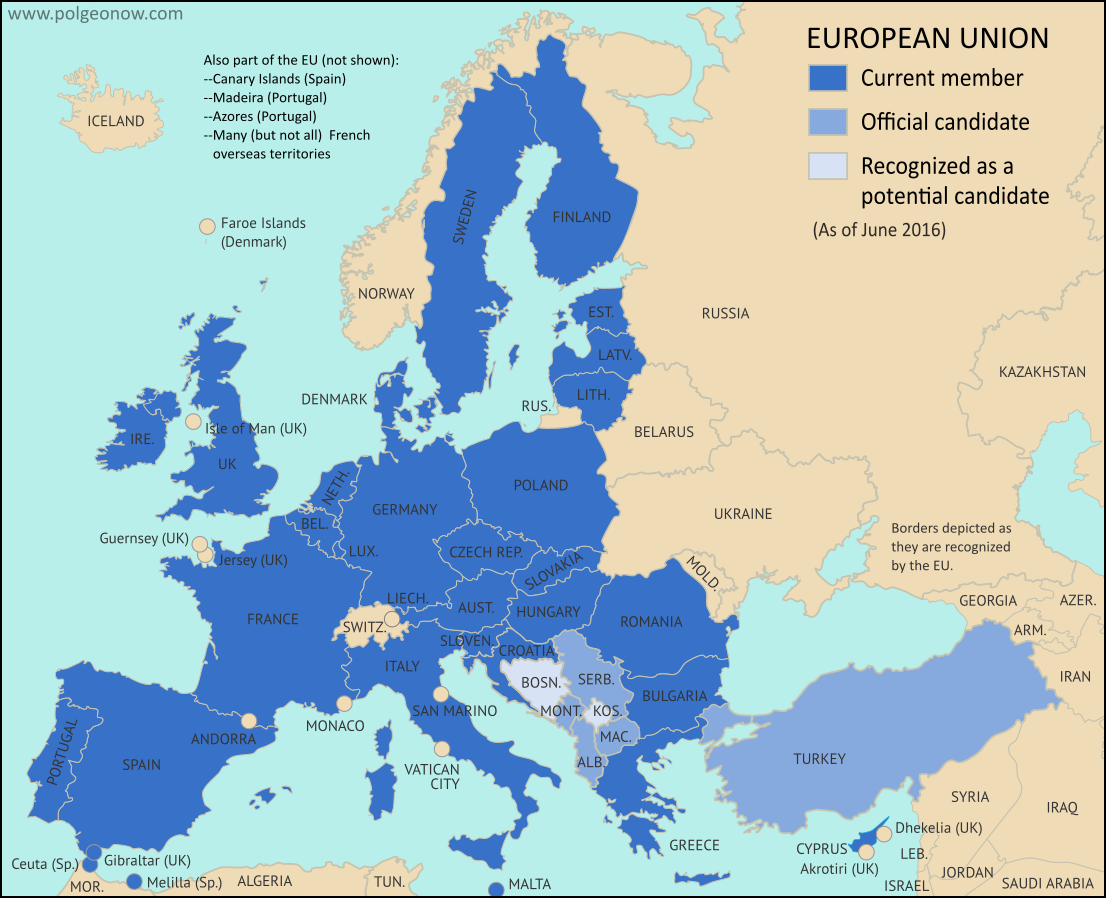
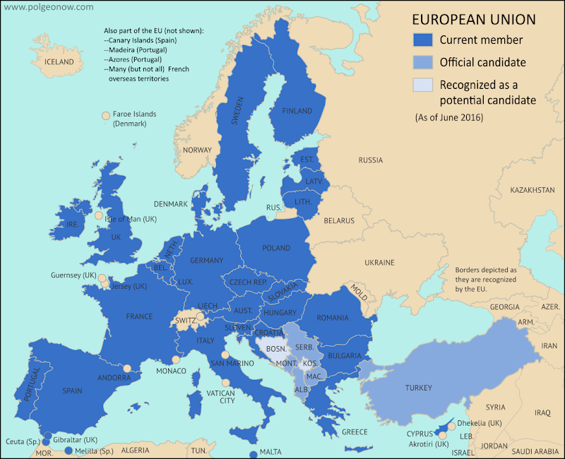
Map of the European Union, including all member countries, official candidate countries, and potential candidate countries, as 2017 (colorblind accessible).
Map of current and future EU member countries

Brexit Process Finally Begins

The United Kingdom (UK) and the European Union (EU) began formal divorce negotiations in Brussels last Monday, June 19, starting a 21-month sprint to the March 2019 Brexit deadline. (“Brexit” is short for “British Exit” from the EU, since “Britain” is another name for the UK.)

UK voters’ surprise choice to leave the EU happened exactly a year ago, on June 23, 2016 – but it didn’t automatically trigger the two-year countdown clock on exit negotiations necessary for departure under Article 50 of the EU’s Lisbon Treaty.

In fact, the referendum didn’t actually do anything, except signal to the British government that its voters wanted to leave. While all leading politicians promised to respect the results, the official process couldn’t start until the UK delivered formal notice to the EU. Theresa May, the UK prime minister who replaced David Cameron last July, wanted to make sure the British government had its priorities and negotiating positions in order before delivering the notice. After many months, she finally did that on March 29, 2017.

How Brexit Affects the UK

Now it’s time for the UK and the rest of the EU to negotiate the details of the divorce. But the UK already wasn’t part of the EU’s free-travel Schengen Area, or part of the shared-currency Eurozone. So what will actually change when the country quits?

“Hard Brexit” vs. “Soft Brexit”

Most details of the UK’s break from the EU are still unknown, but the many possibilities can be divided into two general categories: A “Soft Brexit” would allow the UK to keep some of its special economic ties to the EU, and maybe even the Single Market arrangement that lets goods, money, services, and labor move freely between member countries (the so-called “four freedoms”).

“Hard Brexit”, on the other hand, would mean a clean break from the Single Market, requiring the UK and the EU to negotiate their economic relationship from scratch. The EU insists on including the “four freedoms” as a package deal, so if the UK doesn’t want one of them, it’ll have to give up access to all of them. EU leaders fear that letting the UK pick and choose the best parts of membership might encourage other countries to do the same.

Some non-EU member countries, like Norway and Switzerland, do have partial membership in the Single Market; they generally still have to accept the “four freedoms”, but are allowed exceptions from certain market-wide regulations. They also were never in the EU to begin with, so they were able to negotiate from a stronger position.

Most of the potential changes involve the EU’s “Single Market”, a system that allows goods, money, services, and labor (people) to move around inside the EU as if it was all one country. (Because the UK isn’t part of Schengen, it’s allowed to do border checks and set its own visa policies for non-Europeans; but the Single Market guarantees that citizens of other EU countries can still move to the UK and work there.)

Here are five of the biggest areas where things might change when the Brexit is complete:

1

The Issue: Immigration

Why It Matters: Immigration was one of the driving issues behind the Leave campaign’s success in the Brexit vote last year. Then-Prime Minister David Cameron had promised to drastically reduce migration; but as long as EU law required free movement of labor for EU citizens in and out of Britain, his hands were pretty much tied.

Brexit supporters ran on a platform of regaining control over the country’s borders, promising to limit immigration to much smaller rates than British people are used to now. Since the immigration issue was one of the most visible of the campaign, it’ll be a big deal in the news during negotiations.

What Might Happen: Current Prime Minister Theresa May has consistently said Brexit must mean full control of the UK’s borders and the flow of people coming into the country. While politicians aren’t known for keeping their promises, this is one she’s been clear on for so long that it would be hard for her to break it.

In an April interview, however, May expressed openness to an “implementation period” in which businesses and governments would have time to adjust to new policies. This could include an extension of the free movement of people – though May still insisted that border and immigration policy would be under British control during that period.

2

The Issue: The Border with Ireland

Why It Matters: One of the more difficult circles to square will be the fate of the border between Ireland (an independent country) and Northern Ireland (a part of the UK). Even though the UK isn’t part of the EU’s Schengen free travel area, it has a special agreement to keep the Irish border open to travelers, and the “four freedoms” of the EU Single Market let residents easily do business on either side.

From the 1960s to the 1990s, some 3,500 people in Northern Ireland were killed in a violent conflict over whether the region should join independent Ireland or stay in the UK. The Good Friday Agreement of 1998 led to a cease-fire that’s mostly held since, probably in part because the border is “irrelevant”. But that could all change after Brexit, when the boundary might come to divide the EU Single Market from a border-controlled UK. Meanwhile, tens of thousands of jobs are threatened if cross-border economic activities get cut off.

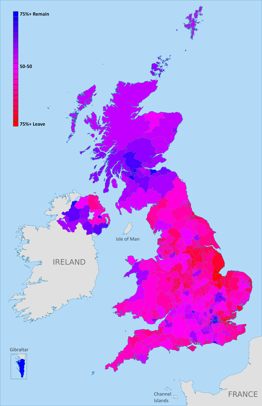
In last year’s Brexit referendum – where Irish citizens residing in the UK were allowed to vote alongside their British neighbors – Northern Ireland voted against leaving the EU, but with sharp differences from district to district.

Gibraltar and Brexit

Brexit negotiations will also decide the future of Gibraltar, a tiny UK-controlled peninsula attached to southern Spain. The territory, though not officially part of the UK, has been under British control since 1713, and some in Spain hope to use the negotiations as leverage to advance their own country’s claims to it.

The EU has promised Spain veto powers over any future trade deal involving Gibraltar, which would allow the Spanish government to “demand concessions or make the border with Gibraltar harder to cross, effectively isolating the territory.” Whether Spain will use its power that way is still unknown.

Meanwhile, the May government has insisted that British policy toward Gibraltar – which includes promises not to give the territory to Spain without its residents’ permission – will not change. (Gibraltarians voted overwhelmingly against Brexit last year, but are even more against joining Spain.)

What Might Happen: Former UK prime minister Tony Blair thinks a hard border with checkpoints and passport controls “really would be a disaster.” Fortunately, both sides have said they want to leave the border as open as possible: May has promised work for a practical solution allowing free travel between Ireland and Northern Ireland while still “protecting the integrity of the UK’s immigration system”, and the EU negotiating guidelines call for a “flexible and creative” approach. Some have suggested this could mean an open border in Ireland, with a “hard border” separating Northern Ireland from the rest of the UK.

However it turns out, you can bet PolGeoNow will be covering these developments!

3

The Issue: Citizens’ Rights

Why It Matters: Thanks to the free movement of people guaranteed by the EU, about 1.2 million British nationals live in other EU states, and 3.2 million non-British EU citizens live in the UK. Many have lived there for decades. Until now, they’ve enjoyed access to most of the same rights and privileges as their local neighbors, but Britain’s exit from the EU opens that up to debate.

If no agreement is reached, EU citizens wishing to stay in the UK would have to deal with British immigration laws, which advocacy groups say are already some of the strictest in Europe. They could also lose access to other services they have now, like health care, social security, and pensions. The same thing could also happen to UK citizens living in other EU countries, like the half-million British expats who have relocated to sunnier Spain and France

What Might Happen: Both sides generally favor allowing existing residents to stay and retain access to services, though the details will take time to hammer out. The EU wants these rights guaranteed by the European Court of Justice (ECJ), but the UK government has been clear that the ECJ will not have any jurisdiction in Britain after Brexit. Another issue is what day citizens must arrive by to be eligible under the agreement: The day of the referendum? The day Article 50 was triggered? The day an agreement is ratified? We should find out soon, since both the EU and the UK have agreed citizens’ rights is one of the first topics on the agenda.

4

The Issue: “Passporting”

Why It Matters: Confusingly, “passporting” has nothing to do with what we usually think of as a passport: the identity document that gets stamped when you enter a new country. In this case, it’s actually an authorization that allows banks and other financial institutions in one EU country to do business in the any of the others. This is a specific part of the Single Market, but it’s especially important because London’s status as Europe’s unofficial “financial capital” means there’s a huge volume of cross-border financial business between the UK and the rest of the EU. One estimate indicates that if the UK lost all EU passporting rights, it could cost almost $25 billion in annual revenue. Another says London banks may have to move close to $2 trillion, or 17 percent of the UK banking system, to EU-based locations. Yet another claims that up to 80,000 jobs in the finance sector could leave London in the next two years as banks prepare for the worst.

UK Brexit vote map: Map of election results in Britain's June 2016 referendum on leaving the European Union (EU). Continuous red-to-blue color scheme gives a more honest depiction of the similarities between different election districts. Colorblind accessible.
Map of UK Brexit vote results

What Might Happen: Only EU-based firms are eligible for passports, so unless an exception is negotiated as part of Brexit, British banks will lose that right. It won’t stop them from conducting business elsewhere, but it does mean they have to apply for a license in each individual country. Ominously for the UK, new French president Emmanuel Macron is on the record saying British financial institutions shouldn’t get a special deal. Britain’s finance industry is already expecting to lose full passporting rights, but hopes a more limited deal could allow some important services to continue.

5

The Issue: Economic Access

Why It Matters: This really is the issue of the whole negotiation process; it’s woven into all the other topics discussed above. How close and what type of an economic relationship will the UK and the EU have after Brexit is finalized?

What Might Happen: Though anything is still technically possible at this point (staying in the Single Market, getting out, keeping other agreements, or temporarily staying in while a new relationship is finalized), May’s government has been fairly clear about its plans to pull the UK out of the Single Market and renegotiate its relationship with the EU from scratch.

But since her Conservative Party lost its parliamentary majority in June’s snap elections, there’s been a push to at least keep Britain in the EU’s customs union. A customs union is a less-ambitious version of the Single Market, where member countries have a shared policy on imports from non-members, and no taxes on importing or exporting between members. It doesn’t include free movement of people, or the unified rules of business that make free movement of labor and services practical in the EU.

Only time will tell how the recent electoral losses will affect May’s negotiating positions, but the decision on whether to allow free movement of people will be the linchpin. If the UK is willing to accept this, it can get the greater economic access that Northern Ireland and London’s financial sector want. But if full control over British borders is non-negotiable, the UK will get only partial access at best.

Following this story? View all Brexit articles on PolGeoNow!
UK Votes to Quit EU: Map of How Britain Voted in the Brexit Referendum

(Subscribers click here to view this article in the members area.)

By Evan Centanni

UK Brexit vote map: Map of election results in Britain's June 2016 referendum on leaving the European Union (EU). Continuous red-to-blue color scheme gives a more honest depiction of the similarities between different election districts. Colorblind accessible.
Map of election results in the UK’s “Brexit” referendum. Modified by Evan Centanni from Wikimedia map by Mirrorme22, Nilfanion, TUBS, and Sting (CC BY-SA).

UK Votes to Quit EU
The results are in for yesterday’s referendum on UK membership in the European Union, and the winner is “Leave”. Brits voted by a margin of 52% to 48% in favor of exiting the European Union, making a “Brexit” (British exit from the EU) more or less guaranteed in the coming years. Britain will become the first member country ever to leave the EU, and the British overseas territory of Gibraltar is expected to get pulled out with it.

Learn More: Brexit: 9 Geography Facts You Should Know About the Referendum and Britain’s EU Membership

Who Voted to Stay
Voter tendencies varied a lot from place to place. Support for the “Remain” side was strong across Scotland, culturally Irish parts of Northern Ireland, the London area, and a handful of other cities in England (led by Cambridge, Oxford, and Brighton).

By far the greatest show of support for Remain was a win by 96% in Gibraltar – which isn’t even in the UK proper, but got to vote because of its unique status as a British external territory that’s in the EU.

Photo Essay: Gibraltar and the Brexit Referendum

Gold: Districts with over 50% for Remain
Blue: Districts with over 50% for Leave
Map from Wikimedia Commons (click for more info)

Who Voted to Leave
The “Leave” vote, on the other hand, was strongest in eastern England, with substantial support from all across England, Wales, and the most ethnically British parts of Northern Ireland. The vast majority of the UK’s population lives in England, and this was enough to carry the referendum.

The district with the highest support for Leave was Boston, England, where 76% of voters favored leaving the EU

England, Wales, Scotland, and Northern Ireland
Taking the UK’s “constituent countries” as wholes, England and Wales each voted 53% for Leave vs. 47% for Remain, while Scotland supported Remain by 62% to 38%, and Northern Ireland supported Remain by 56% to 44%.

Scotland was the most consistently supportive of Remain, with every district at least 50% in favor of staying in the EU. England, Wales, and Northern Ireland all had some districts that went each way, though Northern Ireland was probably the most geographically divided, with 7 districts favoring Leave, and 11 favoring Remain.

Brexit: 9 Geography Facts You Should Know About the Referendum and Britain’s EU Membership

(Subscribers click here to view this article in the members area.)

By Evan Centanni 

The European Union. Click for full map and list of members.

Today the UK is voting on whether to leave the European Union. If you’ve been paying attention to the news, you’ve probably heard about the intense debate over whether Brits should vote “Leave” or “Remain”. But if you’re like me and mainly in this for the geography trivia, here are some fun facts you might not know about the so-called “Brexit”:

1. The UK has been a member of the EU since before there was an EU

The European Economic Community (EEC), founded in 1957 for economic cooperation between democracies in Western Europe, was the predecessor of today’s European Union. The UK wasn’t a founding member of the EEC, but joined in the organization’s first wave of expansion in 1973, along with Ireland and Denmark (plus the British territory of Gibraltar and the Danish territory of Greenland). This made the UK automatically a member when the EEC and related organizations were relaunched as the more ambitious European Union in 1993.

2. Long before the UK wanted to leave the EU, France didn’t want to let it in

The UK chose not to join the European Economic Community (EEC) in 1957, but changed its mind and applied for membership a few years later. But its first two attempts to join, in 1963 and 1967, were vetoed by French President Charles de Gaulle. De Gaulle thought the UK was too different from mainland Europe, and that allowing it into the organization could only slow down the other countries’ progress. Then, just like now, leaders of Britain’s three major political parties favored membership, while British “anti-European campaigners” wanted no part of it. Still, the EEC’s other five members – Belgium, the Netherlands, Luxembourg, Italy, and West Germany – favored the UK to join, and after De Gaulle lost power in 1969, France conceded the point.

3. The UK would be the first member country ever to leave the European Union

Ever since the EEC was formed in 1957, all the way through the inauguration of the EU and up to today, no member country has ever left the organization. If Britain votes today to leave, it will be the first. But there are three territories that have historically quit the EEC/EU: (1) Algeria, considered part of France until its independence in 1962; (2) Greenland, a Danish territory, which negotiated an exit in 1985; and (3) Saint Barthélemy, a French island in the Caribbean, which opted out in 2012 after splitting with fellow French territory Guadeloupe. Since these three territories were only part of the EU through connections to their parent countries, the organization never actually lost any members.

4. Until 2009, it was arguably illegal for a member country to leave the EU

Overseas territories can more or less leave the EU at will, as long as their parent countries consent. But for member countries themselves – like the UK – the original EEC and EU charters didn’t provide a clear path for exiting the organization. For decades, it was up for debate whether countries had an unwritten right to withdrawal, or whether the treaties binding member countries to the EU were legally permanent. This could have made it a long and bitter legal battle if the UK had tried to quit Europe in earlier decades. But since 2009, with a new treaty revising the basic EU rules, member countries have a guaranteed option to negotiate an exit from the organization (though that treaty was nearly vetoed by voters in Ireland).

5. Many citizens of other countries can vote in the Brexit referendum

The UK and lots of other countries that used to be part of the British Empire (plus a couple that weren’t) are now part of an organization called the Commonwealth of Nations. There about a million voting-age citizens of other Commonwealth countries (such as Australia, India, Canada, or Nigeria) living in Britain now, and British law allows them to vote there as well. But citizens of other Commonwealth countries are only allowed to vote in the referendum if they currently live in the UK.

6. Citizens of other EU countries don’t get a vote – unless they’re from Ireland, Malta, or Cyprus

Citizens of all EU countries also have the right to live in Britain, as part of EU law. But they don’t get to vote in the EU referendum, even if they live in the UK. That is, not unless they’re from Malta, Cyprus, or Ireland. Maltese and Cypriot citizens living in the UK can vote because their countries are also part of the Commonwealth (see above). Ireland left the Commonwealth in 1949, but Northern Ireland is still part of the UK, and a special treaty gives all Irish citizens the right to vote in the referendum if they live in Northern Ireland or Great Britain (British citizens can also vote in Ireland if they move there).

7. Most residents of British overseas territories can’t vote either (except Gibraltar)

The UK still has quite a few overseas territories left over from its colonial days – mostly small islands scattered across the world’s seas. Together, they have a population of about a quarter million people, most of whom are now British citizens. But just being a UK citizen isn’t enough for you to vote in the Brexit referendum – even citizens from England aren’t eligible if they’ve been outside the UK for more than 15 years (and overseas territories aren’t technically part of the UK, even though they legally belong to it). The one exception is Gibraltar, a British territory in southern Europe, whose people have been specially granted the vote as residents of the only British overseas territory that’s inside the EU.

(Photo Essay: Gibraltar and the Brexit Referendum)

The Channel Islands and the Isle of Man, whose special status as “crown dependencies” makes them more like younger siblings of the UK than territorial possessions, aren’t part of the EU, and residents only get to vote if they’ve lived in Britain in the last 15 years.

8. The referendum isn’t technically the last word on whether Britain leaves the EU

When UK citizens go to the polls today, they’re joining in a public consultation on whether their country should quit the European Union. But even if they vote “Leave”, the UK can’t actually exit until its legislature, the Parliament, separately votes to repeal the EU treaty laws. The referendum isn’t actually legally binding, so members of parliament could vote against the will of the people if they wanted. But as BBC says, that would be considered “political suicide“, and probably wouldn’t happen – unless the parliament decides to have early elections, and legislators get replaced by new members campaigning on an anti-Brexit platform. But that’s pretty unlikely too, since two-thirds of the current parliament would have to vote to put themselves up early for re-election.

9. Even if the people vote “Leave”, it will be a long time before Britain actually leaves the EU

Though EU member countries do now have the right to leave the organization, they’re expected to negotiate with the rest of the EU over the details. The 2009 Treaty of Lisbon sets a time limit of two years, after which the exiting country doesn’t have to put up with any more, and can leave whether it’s reached an agreement or not. But many observers think the negotiations would take even more than two years, with the British government agreeing to extend the deadline to avoid a bad arrangement. So even if “Leave” takes the day, the UK will likely be part of the EU for some years to come.

Stay tuned to PolGeoNow for more on the geography of the Brexit referendum!

Learn More: 
Which Countries Are in the EU, Which Aren’t, and Which Want to Join?
What’s the difference between the EU and Europe’s Schengen free travel area?
Which countries use the euro currency? (Hint: Many EU members don’t!)

On the Ground: Gibraltar and the “Brexit” Referendum

This is the first installment of PolGeoNow’s On the Ground, a new series of exclusive photo essays on what political geography looks like in the real world. Whether it’s borders, nationalism, or other geopolitical phenomena, we’ll bring the on-the-ground situations to your screen in vivid detail.

Update 2016-06-24: Gibraltar on Thursday voted in favor of the UK staying in the European Union, by an incredible margin of  96% to 4%. However, the UK as a whole voted to leave the EU, meaning that Gibraltar can expect to get pulled out with it, against the wishes of the Gibraltarians.
 

Photo of the Gibraltar Stronger in Europe campaign office on the British territory's main street. Gibraltar's population is overwhelmingly against a so-called Brexit, or departure of the UK from the European Union.

Subscribers click here to view this article in the ad-free members area. Not a member yet? Learn about PolGeoNow subscriptions!

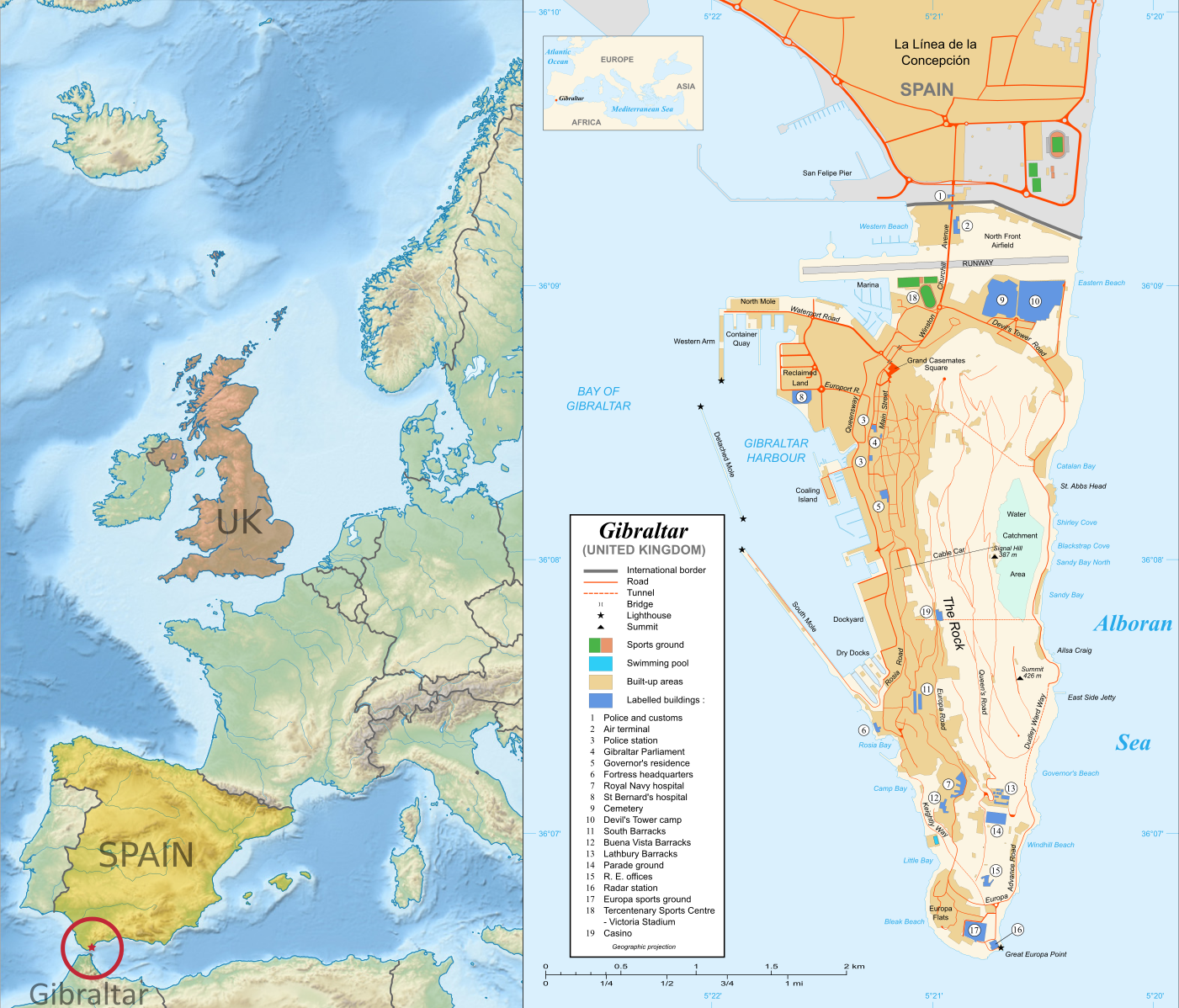
Map of Gibraltar and its location in Europe relative to the UK and Spain
Right: Map of Gibraltar by Eric Gaba (source; CC BY-SA)
Left: Gibraltar’s location in Europe (based on this Wikimedia Commons map by TUBS; CC BY-SA)

Gibraltar prepares to vote on whether UK should leave European Union
Last month, PolGeoNow’s Evan Centanni and Meihsing Kuo visited the small British territory of Gibraltar (pronounced “jih-BRALL-ter”), one month ahead of the UK’s referendum on whether to leave or remain in the European Union (EU).

Gibraltar, a tiny peninsula connected to Spain – and claimed by the Spanish government – is the only British overseas territory that’s part of the EU. It’s also the only external territory whose residents are eligible to vote in the so-called “Brexit” referendum without living in the UK proper. (“Brexit” is an abbreviation for “British exit” from the EU.)

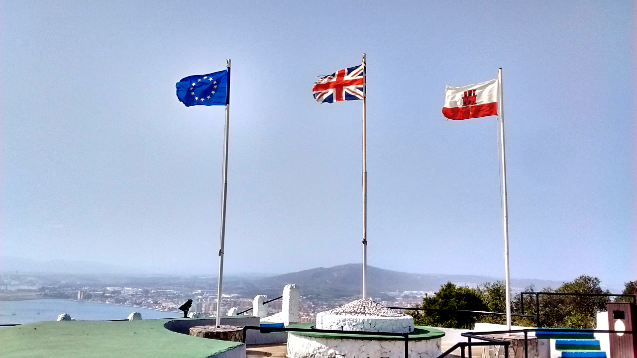
Photo of the European Union (EU), United Kingdom (UK), and Gibraltar flags flying side by side. Gibraltar is the only British territory that's also part of the EU.
Gibraltar flies the European Union flag (left), the flag of the United Kingdom (middle), and its own flag (right)

Gibraltar is a short walk from the Spanish town of La Línea, whose name means “the line” in Spanish – a reference to the line of fortifications Spain built along the border in the 18th Century, when it was still trying to capture the peninsula from Britain by force. (The town’s full name is La Línea de la Concepción, a reference the doctrine of the Immaculate Conception, a central tenet of the Spanish forces’ Roman Catholic religion. Incidentally, most Gibraltarians are also Catholic.)

Because Gibraltar and Spain are both part of the EU, residents of both are free to live or work in the other. Thousands of people live in Spain, where food and rent are cheaper, and commute to work in Gibraltar, where wages and employment are higher. Gibraltar residents also rely on the semi-open border for access to affordable goods from Spain. But that could all come grinding to a halt if the UK decides to leave the union.

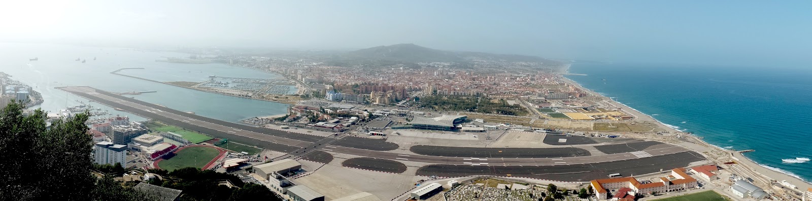
Aerial-style photo of the entire border between La Linea de la Concepcion, Spain, and the British territory of Gibraltar, as seen from atop the Rock of Gibraltar. At front and center is the Gibraltar Airport and runway.
The entire border of Spain (background) and Gibraltar (foreground), as seen from the Rock of Gibraltar. The border runs approximately along the far edge of the airport facilities. Click to see the picture at full size. (Photo by Meihsing Kuo)

Gibraltar is a special EU territory that’s outside the Customs Union and the Schengen Area, so there are still passport and customs checks at the border (though they seemed pretty lax to us). But in pre-EU days, Spain closed the border altogether as a way of protesting British control of the peninsula.

Photo of the border crossing facility between La Linea de la Concepcion, Spain, and the British territory of Gibraltar, including everyday vehicle and foot traffic.
Crossing the border from Spain into Gibraltar. In the background is the Rock of Gibraltar.

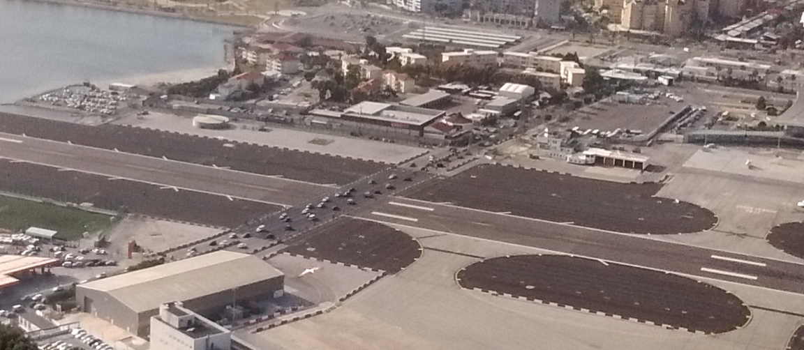
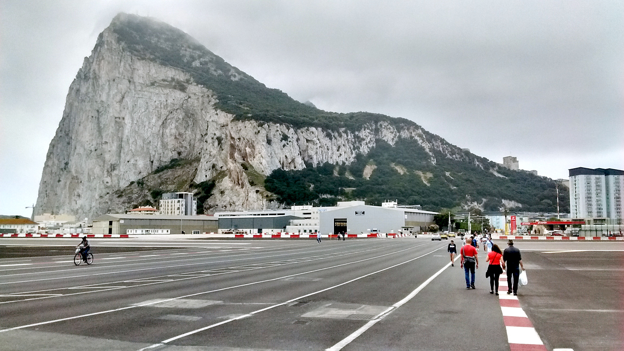
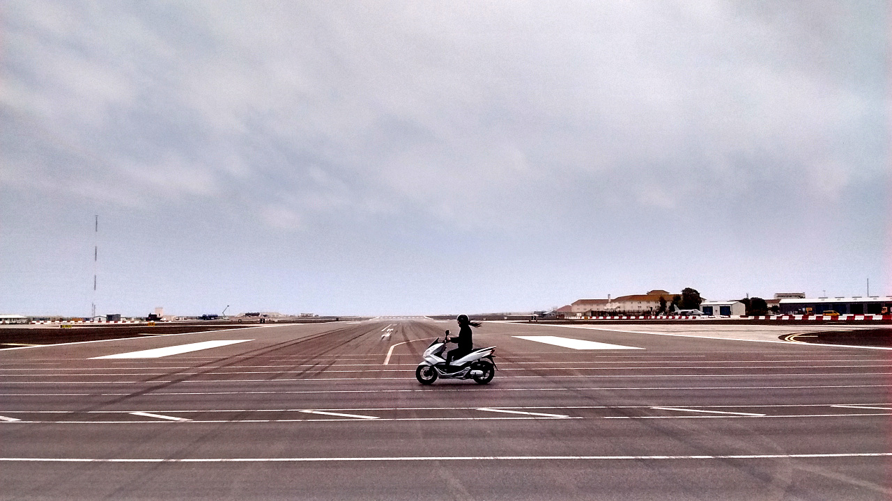
As a funny side-effect of Gibraltar’s position on a tiny peninsula, all traffic across the border has to cross the runway of the Gibraltar airport. There are only five or ten airplane takeoffs and landings each day, but each time there is one, cars and pedestrians have to wait for it to finish before they can go from Spain to Gibraltar or back. A planned traffic bypass is years overdue.

Photo of an airplane landing at the Gibraltar airport, crossing the only road that passes between Spain and the British colony, and temporarily stopping all cross-border traffic.

Photo of cars and other traffic crossing the runway of the Gibraltar airport after having waited for a plane to land. The road crossing the runway is the only land route in or out of the British territory which borders Spain.

Photo of pedestrians and a cyclist crossing the runway of the Gibraltar airport. The road crossing the runway is the only land route in or out of the British territory which borders Spain.

Photo of a motorcycle crossing the runway of the Gibraltar airport. The road crossing the runway is the only land route in or out of the British territory which borders Spain.

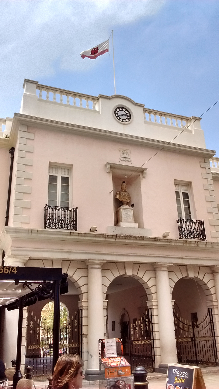
Photo of the Gibraltar Parliament building, headquarters of self-government in the highly-autonomous British territory.
The Gibraltar Parliament building

Unlike British colonies of the past, Gibraltar is almost completely self-governed by its own elected parliament. For internal matters, the Gibraltar parliament doesn’t even legally answer to the British parliament in Westminster. But although Gibraltar’s not considered part of the UK, its land officially belongs to the UK, and it can’t have its own military or international relations. That means if the UK cuts ties with the EU, Gibraltar is along for the ride.

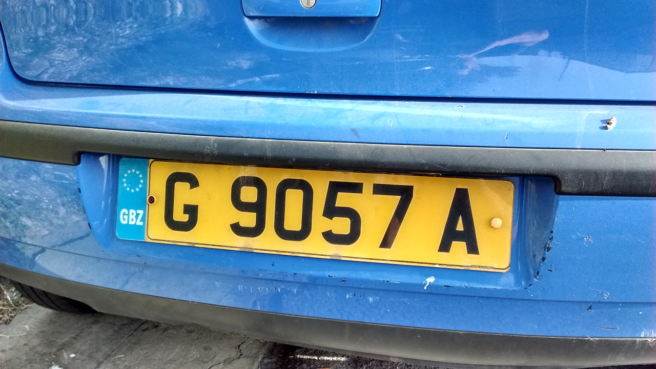
Photo of a yellow vehicle registration plate (license plate) in Gibraltar, showing the pan-European plate design and GBZ country code designation.
Gibraltar vehicle plates have their own country code – GBZ.

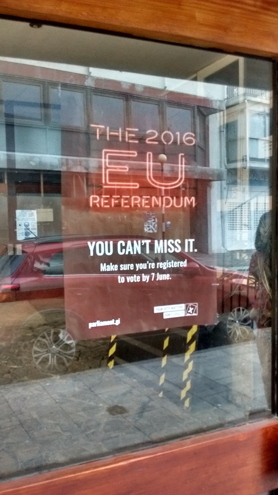
Photo of a bring-out-the-vote poster in a window in Gibraltar, posted by the territorial government to remind residents to vote in the upcoming Brexit referendum on whether Britain should leave the European Union (EU)
Gibraltar government promoting voter turnout in the “Brexit” referendum

Gibraltarians are able to vote in EU elections through a special arrangement that treats them as constituents of southwestern England, and the same arrangement will allow them to vote in the “Brexit” referendum. Though the territory’s 23,000 registered voters are just a drop in the bucket compared to the 45 million or so in the UK, this referendum might come right down to the wire, so it’s not out of the question that they could make a difference.

In any case, Gibraltarians want to be heard, even if only as justification to demand help from the UK if they do get pulled out of the EU. Because of the Gibraltar’s heavy dependence on the border, all three of the territory’s political parties are campaigning for the UK to remain in the union. And what about regular voters? A local newspaper poll found that 88% of people who planned to vote supported staying in the EU.

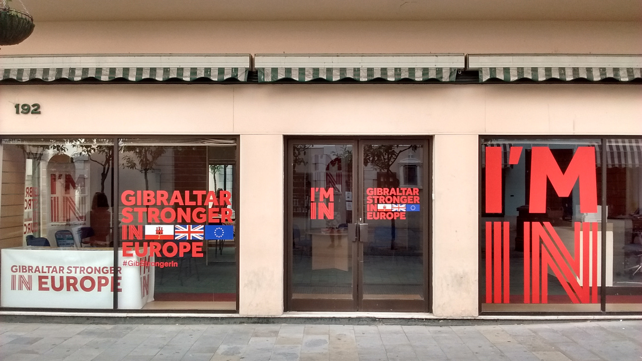
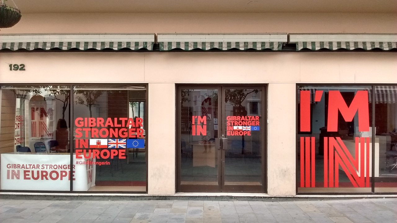
Photo of the Gibraltar Stronger in Europe campaign office on the British territory's main street. Gibraltar's population is overwhelmingly against a so-called Brexit, or departure of the UK from the European Union.
The Gibraltar chapter of Britain’s anti-Brexit “Stronger In” campaign has a prominent office on the town’s main street.

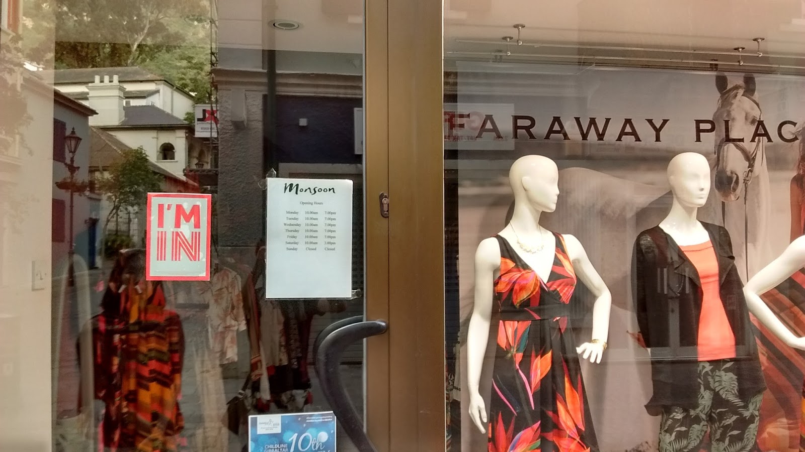
Photo of a shop window in Gibraltar, prominently displaying a sticker that reads I'm In, indicating that the business supports voting for the UK to remain in the European Union (EU) in the upcoming Brexit referendum.
Continued EU membership is uncontroversial in Gibraltar. “I’m In” stickers show many local businesses’ open support of the campaign to vote against leaving the EU.

It’s hard to say exactly what will happen to Gibraltar if the UK does choose to quit the European Union – and that uncertainty is part of what most Gibraltarians are trying to avoid. For now Gibraltar seems content to be a British territory: residents have already twice voted against joining Spain. But if they feel betrayed and abandoned by a UK that wants no part in the EU, could demands for greater autonomy or even independence be around the corner? Only time will tell.

Photos and text by Evan Centanni, except where specified otherwise. All rights reserved.

Maps of How Scotland’s Regions Really Voted

Good geographers know that maps can lie to you. Every map emphasizes some aspects of a place at the expense of others, giving it a lot of power to lead careless readers astray. Maps of Scotland’s recent independence referendum are misleading us about the reality, even if not intentionally.

Premium members click here to view this article in the ad-free members area. Not a member yet? Subscribe now!
 

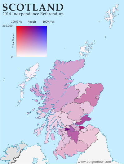
Map of results in Scotland's September 18, 2014 independence referendum. Voters were polled on whether or not to separate from the UK. Map shows relative proportion of yes and no votes for each of Scotland's council areas, using a gradient rather than contrasting colors for small differences.
Map by Evan Centanni, based on blank map by TUBS and NordNordWest (CC BY-SA)

By Evan Centanni

Misleading Maps
By now you’ve probably heard the results of Scotland’s independence referendum: voters chose “no” by a solid margin of 55% to 45%. Check out our previous article to learn more about what would have happened if Scotland had voted “yes”.

Maps like this one from the BBC and this one from Wikipedia have popped up since the results came out, showing how each of Scotland’s council areas voted. Most of the country is in red for “no”, with a few “yes” areas in green.

But if one area went 51% for “yes”, and another 51% for “no”, those two areas actually voted almost identically – yet contrasting red/green maps make us feel like they’re polar opposites (not to mention that one-in-thirty readers has trouble seeing the difference between red and green).

How the Councils Really Voted
Whether each area’s people voted just over or just under 50% in favor isn’t actually that important. What matters is how far the balance was tipped in each region. This is not the U.S. presidential election, where the final vote is actually made by delegates obligated to go by the majority in each state. All the votes across Scotland were pooled together to determine the result, so which side of the 50-yard line each area came out on has no effect .

In reality, the vote was split in every part of Scotland. No council area voted more than 58% in favor of independence or more than 68% against. The above map is designed to show how close the vote really was all across the country. Since no area came close to voting completely for independence (blue) or completely against it (red), on this map Scotland’s council areas all end up colored in purplish hues.

For Your Reference: Map of Scotland’s council areas with names labelled

Map of results in Scotland's September 18, 2014 independence referendum. Voters were polled on whether or not to separate from the UK. Map shows relative proportion of yes and no votes for each of Scotland's council areas, using a gradient rather than contrasting colors for small differences and shading to represent the total number of valid ballots case in each region as a way of normalizing for population.
Map by Evan Centanni, based on blank map by TUBS and NordNordWest (CC BY-SA)

The Glasgow metropolitan area, the main region where independence bagged more than half the vote, appears as a slightly bluish purple lump in the bottom-center, while border areas that voted “no” by a larger margin turn out purplish-red (as does Orkney, the group of islands just north of the Scottish mainland). Most of the remaining councils voted more narrowly against independence, showing up in intermediate hues.

Population Matters
In fact, the above map still hides an important factor in the results: the council areas didn’t each have the same number of votes. While turnout was high across the country (75-91%), population varies drastically from council to council. Glasgow city cast nearly 356,000 ballots, while rural Orkney had a mere 14,887.

The second map (at left) tries to show the relative importance of each area in deciding the countrywide result. Here, the same range of purple hues are made lighter or darker depending on how many total valid ballots were cast in each council area. It’s a bit more complicated to read, but the message is clear.

Flag of ScotlandCountry Name:  
• Scotland (English, Scots)
• Alba (Scottish Gaelic)
Current Status:  
Country within the United Kingdom 
Capital: Edinburgh

The outer islands’ voting populations are so small that they look white to the naked eye, with each group contributing only about five percent as many votes as the biggest city. Meanwhile, Scotland’s two major cities of Glasgow (left, bluish) and Edinburgh (right, reddish) stand out sharply with their huge numerical advantage.

The country’s number three city, Aberdeen, seems to have its votes divided between the surrounding Aberdeenshire (large, medium-shaded chunk at upper-right) and the city proper (lighter-shaded kernel along the coast). Meanwhile, the Scottish Highlands, the huge region at upper-left, are sparsely populated but carry some collective clout due to sheer size.

Maps that contrast colors on either side of the 50% mark may be a simple and attention-catching way to show election results, but they mislead us by making countries look more geographically-divided than they really are.

See Also: How Sharply Divided is Ukraine, Really? Honest Maps of Language and Elections

Scottish Independence Poll: What is Scotland, and What Will Happen if it Votes to Leave the UK?

Premium members click here to view this article in the ad-free members area. Not a member yet? Subscribe now!
 

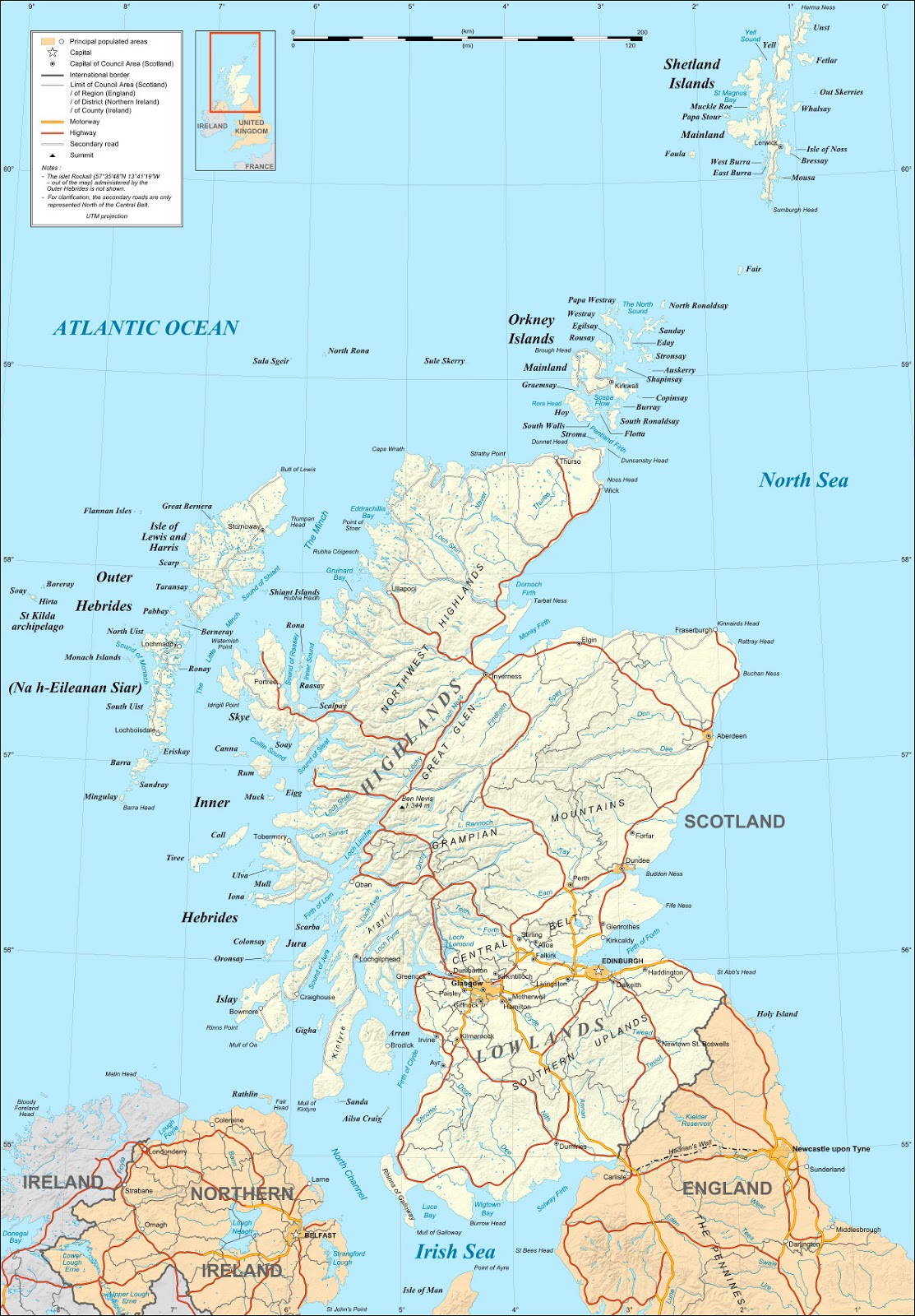
Map of Scotland. On September 18, 2014, Scotland will vote on whether to leave the UK and become an independent country.
Map of Scotland by Eric Gaba (source). License: CC BY-SA

By Evan Centanni

Scotland’s Independence Vote
On Thursday (September 18), residents of Scotland will vote in a referendum on whether to leave the United Kingdom (UK). But is Scotland a country already? What will happen if voters choose “yes” in the referendum? And what other changes would this bring to Scotland and the UK’s political geography? Read on for the answers to these questions and more!

Crash Course: History of Scotland
Scotland is the name of the northern third of Great Britain, the main island of the UK, which is shared with England to the south and Wales to the southwest. It originated as the Kingdom of Alba, an independent Celtic country that was unified around the year 900.

It remained an independent kingdom throughout the Middle Ages, gradually absorbing Anglo-Saxon culture from the south until it came to be ruled by English-speaking monarchs, who called it “Scots” or “Scotland” after the Latin name for the Gaels, the predominant Celtic people of the region.

Starting from the late 1200s, Scotland and England became enemies, and Scotland allied closely with England’s enemy France. But tensions eventually cooled, and in 1603 Scotland’s King James VI inherited the throne of England (where he became known as James I), paving the way for the two countries’ eventual unification. At first, they were still two independent countries that just happened to share the same monarch, but in 1707 their parliaments passed the Acts of Union, controversially joining them together as a single kingdom.

Flag of ScotlandCountry Name:  
• Scotland (English, Scots)
• Alba (Scottish Gaelic)
Current Status:  
Country within the United Kingdom 
Capital: Edinburgh

Then what is Scotland now? Is Scotland a country?
Since the union 300 years ago, Scotland has maintained some separation from England, especially in terms of its legal system and religious institutions. Like England and Wales (and sometimes Northern Ireland), Scotland is still called a “country” today, despite not being an independent country. After the union, the Scottish parliament was merged with the English one in London. But in 1999 Scotland was once again given its own parliament, which eventually came to be dominated by pro-independence parties.

Though Scotland and England are just considered parts of the UK in most world organizations like the UN or the European Union, they do have their own national soccer teams that compete separately in official FIFA events such as the World Cup (See: Which Countries Are (and Aren’t) Members of FIFA?).

The UK won’t just let Scotland leave, will it?
Actually, it will. True, modern countries rarely let pieces of their territory break off without a fight, and usually don’t accept the outcome even if the separatists come out victorious. And even in highly democratic Western Europe, other would-be breakaways like Catalonia face daunting legal obstacles in their quests for independence. But the UK has come a long way since the American Revolution, and since the 20th century decolonization of the British Empire it’s become relatively supportive of self-determination (the right of peoples to govern themselves).

That’s not to say London wants Scotland to go. The British government did agree to allow Scotland’s independence referendum, but is campaigning doggedly for a “no” vote. In a very rare show of unity, all three of the UK’s major political parties have joined in the “Better Together” campaign to talk Scotland out of secession. Nevertheless, the British government in London has clearly asserted that they’ll accept the results of the vote, even if the answer is “yes” to Scottish independence.

If it’s a “yes”, will Scotland become independent right away?
No, it will stay part of the UK for a little bit longer. The Scottish and British governments will need months or years to negotiate the exact terms of separation, such as “the allocation of assets and liabilities.”

Last year, Scotland’s government proposed March 24, 2016 as the date to declare independence if the referendum passes, but it’s not set in stone yet. That would be the day after the current Scottish parliament finishes its term in office, and March 24 is also the anniversary of the “Union of the Crowns,” when King James first became the monarch of both Scotland and England (see history crash course above).

What changes will the UK have to make if Scotland leaves?

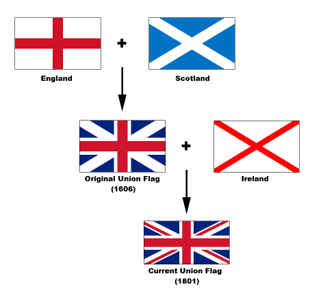
Diagram of the component flags of the UK's Union Jack flag, including the flags of Scotland, England, and Ireland. The UK will likely have to change its flag if Scotland becomes independent.
Development of the UK’s flag (source)

An independent Scotland could keep its current name and flag – ironically, it would be the UK that might have to change. The current full name of the UK is the “United Kingdom of Great Britain and Northern Ireland”, and without Scotland it would only have control over two-thirds of Great Britain.

But even if the UK decides to let that one fly, it will probably still have to change its iconic “Union Jack” flag. The blue background and diagonal white bars of that flag are actually the flag of Scotland, a design known as the St. Andrew’s Cross. Flag enthusiasts are already proposing new designs, many making a point of adding a symbol for Wales, which was left out of the current flag because it was considered part of England at the time the banner was designed.

(See also: Other countries that have changed their flags recently

Will Scotland stay in the EU, NATO, and other important organizations?
Not automatically, in most cases. It will have to re-apply as a new member country for most organizations. The United Nations will probably accept an independent Scotland as long as Britain doesn’t object, though Scotland will have to give up the veto power that the UK gets as a member of the UN Security Council. 

The European Union could be more complicated. It’s technically possible for the EU to keep an independent Scotland in the organization without making it reapply, but there’s a hot debate over whether that would really happen. Meanwhile, if Scotland applies anew to the EU, there’s a chance it could face a veto from Spain, which is determined not to let go of its own separatist region, Catalonia. On the other hand, if Scotland votes “no”on Thursday, it could still end up leaving the EU unwillingly – the British government is planning a 2017 referendum on whether the whole UK should leave the European body. Most Scottish people want to stay in the EU, but they could be outnumbered at the polls by euroskeptics to their south.

NATO membership for an independent Scotland is also uncertain. The Scottish National Party’s anti-nuclear policy could mean the end of the UK Trident program, Britain’s only active nuclear weapons system, which is based in Scotland. Though Scotland’s close relationship to other members would seem to make its entry into the alliance a sure thing, and there are many NATO member countries without nuclear weapons, some think NATO would be annoyed with an independent Scotland for essentially disarming another member, the UK.

What about the Olympics and World Cup?
As mentioned earlier, Scotland already has its own FIFA football (soccer) team, but it currently competes in the Olympics as part of Great Britain. Scottish leaders are hopeful that the country can compete independently in the 2016 Olympics in Brazil, but it could be a bit of a rush if it declares independence that same year.

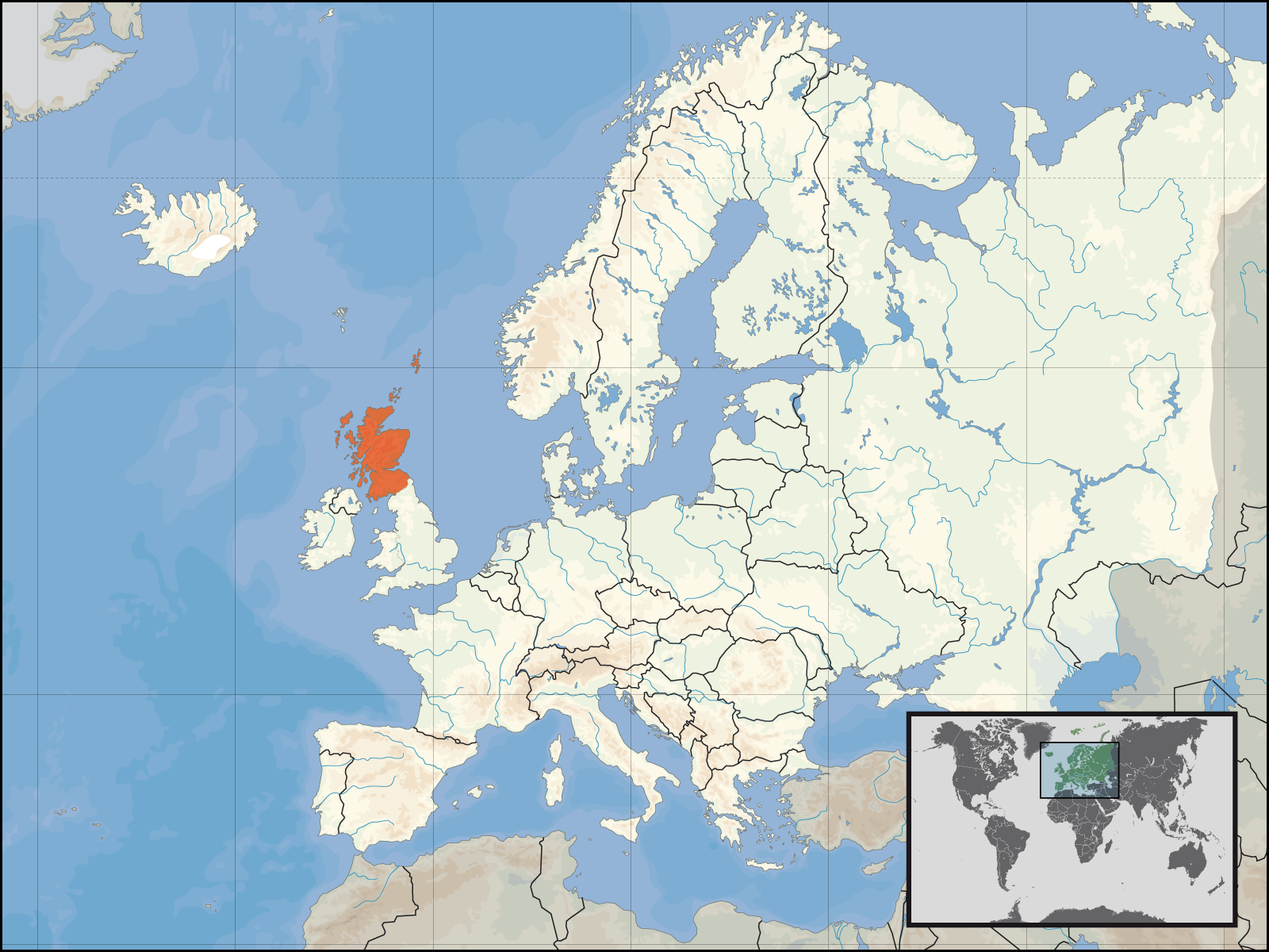
Map of an independent Scotland's location within Europe. On September 18, 2014, Scotland will vote on whether to leave the UK to become an independent country.
Scotland’s location with Europe
Map by Rab-k and David Liuzzo (source)

First, an independent Scotland would first have to prove it’s a real country by joining the UN. Probably not a big problem; in 2011, South Sudan achieved this within days of independence. But a bigger problem might be the time it takes to organize a national Olympic committee – something South Sudan still has yet to do. If Scotland doesn’t get its stuff together quick, Scottish athletes will have to compete under the UK flag one more time. (See also: Which Countries Are (and Aren’t) in the Olympics?)

But can the queen stay?
Scotland’s leader, Alex Salmond, says the independent Scotland would keep Queen Elizabeth II as its monarch, making her Queen of Scotland just as she’s also the Queen of the United Kingdom and 15 other independent countries. However, it may not be up to him: some political forces in Scotland are pushing for a separate referendum on whether to keep the queen or abolish the monarchy and become a republic.

Will all of Scotland go along with independence?
Probably, but that wasn’t always a given. Three island groups along Scotland’s fringes – Orkney, Shetland, and the Outer Hebrides – have been less enthusiastic about independence than many other parts of the country. Earlier this year, a group of islanders tried to organize a second referendum that would allow the island groups to declare their own independence or rejoin the UK if Scotland splits. That plan doesn’t seem to have caught on, but the islands’ local governments have taken advantage of the controversy to secure extra autonomy (self-rule) regardless of whether Scotland leaves the UK or not.

So, what will happen to Scotland if it votes “no”?
If the referendum fails, Scotland will stay part of the UK, probably for a long time to come, since the results will be seen as a popular rejection of separation. But that doesn’t mean nothing will change. In a bid to dissuade Scottish voters from independence, British political leaders have made strong promises that if Scotland stays in the UK, it will get much greater powers of self-government within Britain than it has now. These would include greater control over its finances, taxation, and possibly welfare, big issues in a region that usually votes for the left-of-center Labour Party, yet often finds itself stuck in a Britain ruled by the opposing Conservatives.

What will happen next? Stay tuned to PolGeoNow for more updates on Scottish independence!

Map: The Falkland Islands’ Disputed Seas

The Falkland Islands, a South Atlantic territory disputed between the U.K. and Argentina, held a status referendum this week in which 99.8% of voters defied Argentina by choosing to remain British. But it’s not just about the islands – also at stake are legal rights to the sea for hundreds of miles around.

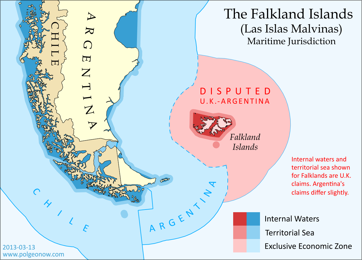
Map of maritime jurisdiction in the seas surrounding the Falkland Islands (Islas Malvinas), including territorial sea, internal waters, and exclusive economic zone (EEZ)
Zones of maritime jurisdiction around the Falkland Islands, highlighting area disputed between the U.K and Argentina. Map by Evan Centanni (country coastlines from the Natural Earth dataset). All rights reserved.

The Disputed Seas of the Falkland Islands
The Falkland Islands are administered by the U.K. as an overseas territory, but are also claimed based on historical arguments by Argentina, which calls them “las Islas Malvinas”. Both countries have signed and ratified the United Nations Convention on the Law of the Sea (UNCLOS), which defines ownership and legal rights for the waters surrounding coastal countries. According to the UNCLOS, each country is entitled to three basic zones of control in its surrounding seas:

Internal Waters
These areas normally include bays and the water between islands or between the islands and the mainland. With some exceptions, internal waters are considered legally equivalent to rivers and lakes, which means the country has total control here. Both the U.K. and Argentina claim an area of internal waters in the Falklands, though their claims are slightly different. Only the British claim is shown on the map above – the Argentine claim is a bit smaller, excluding the channel between the two main islands but stretching farther out to the most distant rocks.

Territorial Sea
The territorial sea is an area stretching up to 12 nautical miles out from the edge of the land or internal waters, which is considered sovereign territory of the state (i.e. an actual part of the country), though the “innocent passage” rule requires that foreign ships still be allowed to sail there without permission. Both the U.K. and Argentina claim a 12 nautical mile territorial sea surrounding the Falkland Islands. The two countries’ claims are slightly different because they’re drawn from the edges of the differing internal waters claims. The U.K. claim is shown on the map above (the small circle at the bottom is the territorial sea around Beauchene Island).

Flag of the Falkland Islands Territory Name:  
Falkland Islands (English)
• Islas Malvinas (Spanish)
Claimants: 
• United Kingdom (U.K.)
• Argentina
Actual Control: U.K.
Status: Overseas Territory (self-governing)
Capital: Stanley

Exclusive Economic Zone (EEZ)
Although the waters beyond the territorial sea are not considered part of the country itself, the country still has some legal rights over the surrounding ocean, up to a maximum distance of 200 nautical miles from the coast or internal waters. This is called the “exclusive economic zone”, and here countries can control the harvesting of resources, scientific research, and environmental protection. When two countries are less than 400 nautical miles apart, they have to come to an agreement about where to draw the border of their EEZs (the default is normally to draw a line halfway between the two coasts).

The Falklands are indeed less than 400 nautical miles from mainland Argentina, but the Argentine government doesn’t consider this to be a problem, because they consider both the mainland EEZ and the Falkland EEZ to be theirs. The U.K. also claims the waters around the Falklands (though it calls them a “fishery conservation zone” instead of an EEZ), but draws its line short of the halfway point between the islands and Argentina. This might be intended as a show of modesty, though Argentina isn’t flattered, since it doesn’t think the U.K. should be there in the first place.

The Continental Shelf
Beyond the end of the EEZ, countries are also allowed to claim economic rights to the seafloor (but not the water above it), if it is part of the “continental shelf”. The legal definition of this term is a bit different from the way geologists use it, but the basic idea is that if the continent or landmass extends out a ways underwater before giving way to the deep sea, the shallow area is the continental shelf.

This is limited to 350 nautical miles from the shore, as well as detailed rules defining the required depth and slope of the sea floor. But since the U.K. and Argentina both also claim South Georgia and the South Sandwich Islands (not to mention parts of Antarctica), their conflicting continental shelf claims continue southeast from the Falklands EEZ for hundreds of miles. If you’re interested in this extended disputed territory between the U.K. and Argentina, check out this excellent online map made by Durham University’s International Boundaries Research Unit.

Who Really Controls the Seas of the Falkland Islands?
Actual control of these seas follows the U.K.’s claims, since that’s the country that actually controls the islands. Argentina insists this is illegal, and even temporarily occupied the islands in 1982; but it’s unlikely control will change any time in the near future, since the U.K. insists it won’t go against the will of the islanders (most of whom are proudly British, and many of whom have bad memories of Argentina from the 1982 war).

Graphic of the Falkland Islands flag is in the public domain (source).

Feature: Queen Elizabeth’s 16 Countries

Did you know that Elizabeth II is not just the Queen of England and the UK, but of 15 other independent countries too? Read on for quick answers to all your questions about this unusual arrangement…

Map of the Commonwealth Realms - independent countries that share the British monarchy.
Map of the Commonwealth realms – independent countries which share the British monarchy. Current realms in dark blue, former realms in light blue. By Evan Centanni, modified from public domain Wikipedia map (source).

Which countries share the Queen?
Her Majesty Queen Elizabeth II is the official head of state for 16 different independent countries, known as the “Commonwealth realms” – a smaller club than the Commonwealth of Nations, many of whose members are now queenless republics. The current Commonwealth realms, in order of independence, are:

Personal flag of Queen Elizabeth II
Personal flag of Queen Elizabeth II (source) License: CC BY-SA.

 United Kingdom
 Canada
 Australia
 New Zealand
 Jamaica
 Barbados
 The Bahamas
 Grenada
 Papua New Guinea
 Solomon Islands
 Tuvalu
 Saint Lucia
 Saint Vincent and the Grenadines
 Belize
 Antigua and Barbuda
 Saint Kitts and Nevis

Just as the sun never sets in the British Empire, the monarchy never set in the realms – each one inherits the queen’s role from its time as a former British colony (with the exception of northern Papua New Guinea, which passed directly from German to Australian control before uniting with the British south in independence).

Sixteen countries – is that all?
Although the independent realms total 16, the number of “countries” with Elizabeth II as their queen actually increases to 19 when including the four “home nations” that make up the U.K.: England, Scotland, Wales, and Northern Ireland. But that’s not all – as if 16 realms weren’t enough for one woman, the Queen of England also reigns over three Crown Dependencies (Guernsey and Jersey in the Channel Islands, plus the Isle of Man) and the 14 British Overseas Territories, all of which are dependent on the U.K., but aren’t considered part of the kingdom itself. And interestingly, the Realm of New Zealand includes two associated states, the Cook Islands and Niue, which could remain royal subjects even if New Zealand itself were to fire the queen from its government.

Map of the entire reign of Queen Elizabeth II (1952-2012), marking current and former realms and territories.
Entire reign of Queen Elizabeth II (1952-2012). Current in red, former in blue (dark = sovereign realm; light = territory or dependency). Click to enlarge. Excludes Antarctic claims. By Evan Centanni, from public domain map (source).

Historically, there are about 20 more countries which were Commonwealth realms during parts of the last Century, but have since abandoned the monarchy to become republics. Still, the current list is longer than it used to be – at the time of Queen Elizabeth II’s coronation in 1952, there were only seven realms: the U.K., Australia, Canada, New Zealand, Pakistan, South Africa, and Ceylon (now Sri Lanka).


How can countries share the same monarch and still be sovereign states?
Every one of the Commonwealth realms is a fully-fledged independent country and a member of the U.N., despite sharing the same queen. So how does that work? Each country has separately and independently designated Elizabeth II (and her royal line) as its head of state, and the British parliament has no authority whatsoever over the governments of any of the other realms. In a certain legal sense, these 16 countries just happen to have chosen the same family to form their monarchy.

To show this independence, each realm calls the queen by its own national title – she is not only the the Queen of England, but the Queen of Australia, the Queen of Canada, the Queen of the Bahamas, etc. As for Her Majesty, she’s been said to be “equally at home in all of her realms”. But since she has only has one physical body, she still mainly lives in the oldest realm: the U.K. In her other countries, she’s represented on an everyday basis by appointed viceroys (the highest-level viceroys are called governors-general).

But if they’re all controlled by the same person, isn’t that like being one country?

Flag of Elizabeth II, Queen of Barbados
Flag of Elizabeth II, Queen of Barbados. See all flags of Elizabeth II. By Barryob (source). License: CC BY-SA.

Unlike in medieval personal unions, where a single monarch had power over two or more countries, the queen has next to no power in her modern realms. Although there are some decision-making powers ceremonially assigned to her, for the most part she can now only exercise them if asked to by the country’s government. Since modern constitutional monarchies require the royal family to stay out of politics, the queen serves as a symbol of a loyalty to one’s nation that transcends political differences.

Still, this must create some awkward situations now and then, right?
Absolutely – since the queen mainly acts only on the “advice” of her countries’ governments, she officially takes both sides whenever two realms disagree, and has also been found engaging in trade competition with herself. She may also be simultaneously neutral and at war when one realm is involved in an international conflict and others are not; in extreme cases, the monarch of the Commonwealth realms may even declare war against him or herself, as happened in the Indo-Pakistani War of 1947 (during the reign of King George VI).

Learn More: The Commonwealth of Nations includes a lot more than just the Realms – so what is it, exactly?