War in Libya: Map of Control in August 2015

There are newer versions of this map available. To see them, view all Libya updates.

This is the first of a series of professional Libya control maps. Secure your access to future updates: sign up now for our conflict map subscription service!
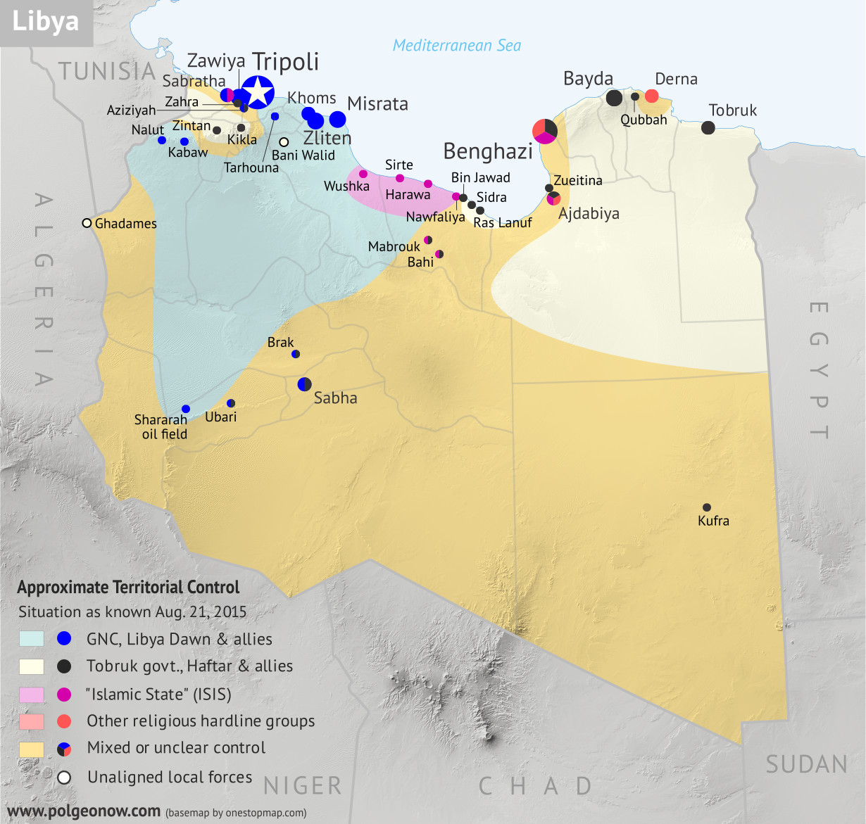
Libya control relief map: Shows detailed territorial control in Libya's civil war as of August 2015, including all major parties (Tobruk government, General Haftar's Operation Dignity forces, and Zintan militias; Tripoli GNC government, Libya Dawn, and Libya Shield Force; Shura Council of Benghazi Revolutionaries and other hardline Islamist groups; and the so-called Islamic State). Also file under: Map of Islamic State (ISIS) control in Libya.
Base map by Koen Adams of onestopmap.com, with territorial control by Evan Centanni. All rights reserved.

Subscribers click here to view this article in the ad-free members area. Not a member yet? Subscribe now! 

Background summary by Djordje Djukic; timeline by Evan Centanni and T.H.

Included in this free article:

  • Concise summary of events in Libya since the fall of Muammar Gaddafi in 2011
  • Detailed timeline of conflict, changes to territorial control, and political events since 2011, with each mentioned location illustrated on the map above
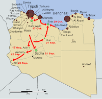
Map showing the final stage of Libya's first civil war (aka the Libyan Revolution) in 2011
The final stage of Libya’s first civil war

Historical Summary: From Revolution to Second Civil War
The Libyan Civil War started with opposition protests against the rule of Muammar Gaddafi, lasting from 15 February through 23 October 2011 and ending with the death of Gaddafi and the victory of pro-opposition forces.

Despite initial claims by opposition activist groups that 30,00050,000 people were killed, most of them civilians whose deaths were caused by Gaddafi’s forces, the estimates were afterwards reduced greatly. A later official estimate established that only 4,700 rebels and their supporters and a similar number of Gaddafi loyalists were killed. An additional 2,100 people were missing, and the number for civilian fatalities was not given, but was no longer claimed to be in the tens of thousands.

Following the end of the war, an interim government was formed in November 2011, and the first public elections took place in January of 2012. However, what followed was a country-wide breakdown of law and order as former rebel groups seized local power in individual places. Many of these groups refused to pledge allegiance to a unified military command, instead reporting to local military councils that became de facto local governments. The rival militias frequently clashed with each other over territory, while vigilante revenge killings and looting and robbery of the civilian population also took place. In addition, 7,000 people  accused of being Gaddafi supporters, mostly civilians (including women and children), remained imprisoned and were subjected to torture. A pro-Gaddafi armed group called the Green Resistance also sprung up conducting hit-and-run attacks against the former rebel groups.

Weapons proliferation also became an issue, with many former Gaddafi-era weapons stockpiles being plundered. This influx of weapons into private hands had effects ranging far beyond Libya’s borders, contributing to the strength of separatists who took over northern Mali in 2012, as well as the religious extremist fighters who soon usurped the separatist revolution. before being beaten back by a French intervention.

During this time, religious radicalism was on the rise in Libya, and on September 11, 2012, extremists attacked the US consulate in Benghazi, killing four Americans. Among the dead was the United States ambassador, Christopher Stevens, as well as two CIA agents.

On 23 December, 2013, the General National Congress (GNC), the legislative authority of Libya elected in July 2012, unilaterally extended its mandate by one year based on one interpretation of the 2011 Constitutional Declaration. Thus they refused to hold new elections that had been expected to happen in January 2014. Following this, public protests against the GNC took place, and General Khalif Haftar proclaimed the dissolution of the GNC. Discontent with the GNC stemmed from it allegedly being dominated by religious conservatives, suppression of inconvenient debates, imposition of gender segregation, and pushes for the introduction of Islamic law as the official basis for national law.

On the morning of 16 May, 2014, general Haftar’s forces attacked religious hard-line militias in and around Benghazi, ultimately sparking what some now call the Second Libyan Civil War. On 25 June, new legislative elections were held for the Council of Deputies (also known as the House of Representatives). Nationalists and liberals won the majority of the seats in the elections. However, a religious conservative block calling itself the new GNC, and made up of politicians who were on the loosing side of the elections, took advantage of support from a coalition of militias known as Libya Dawn to take control of Libya’s capital city of Tripoli. Subsesequently, the newly-elected Council of Deputies moved its seat of power to the eastern city of Tobruk and gained the backing of Haftar’s part of the Libyan National Army.

Over the following year, the GNC set up its power base in the western part of the country, controlling Tripoli, Misrata, Zliten and several other towns. The internationally-recognized Council of Deputies established itself in the east and south of the country, with its de facto capital in Tobruk and control over most of the country’s oil fields. Allied forces also controlled a string of towns in the mountains southwest of Tripoli. A force of Tuareg fighters reportedly allied with Libya Dawn took control of the southwestern sliver of Libya, while contesting the area’s largest town of Sabha with Tebu fighters aligned with the Tobruk government. Local forces took control of the former Gaddafi stronghold of Bani Walid, among unconfirmed allegations that the town’s new administration was made up of Gaddafi loyalists.

Map of the territorial control (Baghdad government, Islamic State/ISIS/ISIL, and Kurdistan peshmerga) in Iraq as of May 2015
Recent map of “Islamic State” control in Iraq, the organization’s home country

The Shura Council of Benghazi Revolutionaries, a coalition of radical religious militias, took control of the eastern Libyan town of Derna and continued contesting Benghazi with Haftar’s “Operation Dignity” forces. During this time, Libya also saw the entry of the so-called “Islamic State” (a.k.a ISIS), which also initially set itself up in Derna, but was pushed out by the Shura Council. It then took control of the north-central city of Sirte, Gaddafi’s hometown, and its surrounding area, after evicting GNC forces. Egypt and the United Arab Emirates conducted airstrikes on several occasions against both the GNC forces and IS fighters, in support of the Tobruk government, while Qatar and Turkey gave their support to the GNC.

Overall, between January 1, 2014, and July 21, 2015, one estimate said that 3,934 people had been killed in violence throughout the country. The multi-sided conflict continues today despite multiple attempts to strike a peace deal between the rival governments.

CHRONOLOGY OF EVENTS
The following is a detailed timeline of important events related to conflict, territorial control, and politics in Libya from 2011 to the present.

Part I: An Unstable Peace

2011.10.24 The former rebels of the National Transitional Council declared the Libyan Revolution complete, after defeating the forces of former national leader Muammar Gaddafi, receiving recognition from the UN as Libya’s legitimate government, and finally tracking down and killing Gaddafi himself. The civil war had lasted about eight months, resulted in thousands of deaths, and left the country in control of a patchwork of local militias.

2012.01.23-25 Local fighters took control of Bani Walid, once a Gaddafi stronghold, after a dispute with revolutionary government forces. A ceasefire deal recognized the local groups as the legitimate administration of the town.

2012.09.11 A pair of attacks in Benghazi , later attributed to the religious extremist group Ansar al-Sharia, killed the US ambassador and three other US personnel.

2012.10.24 Government forces and fighters from Misrata seized control of Bani Walid from local forces after a series of aggressions between rival militias from the two towns.

2013.06.08-15 Clashes erupted between pro-government forces and opposing groups in Benghazi.

2013.07-08  Government-appointed oil security chief Ibrahim Jathran went rogue, using his forces to seize control of the Ras Lanuf and Sidra oil export terminals while advocating for a decentralized government and eastern autonomy. At some point, the Zueitina oil terminal and Tobruk’s Hariga oil terminal also came under the control of Jathran’s rebels.

2013.10.10 Libya’s prime minister, Ali Zeidan, was briefly kidnapped, in what he afterwards called an attempted coup.

2013.10 By the end of October, Libya’s crucial oil industry had been brought nearly to a standstill, as a variety of opposition fighters and protesters from around the country blocked key infrastructure sites from operating.

2013.11.03 A collection of important officials unilaterally declared the formation of an autonomous government for eastern Libya, called Barqa in Arabic, or Cyrenaica by its traditional English name. The movement boasted the support of Ibrahim Jathran and his oil port blockade.

2013.11.21 Various militias, still operating in Tripoli since the revolution, agreed to leave the capital city and allow the government to assume control.

2014.01.18-29 During clashes in Sabha, fighters described as Gaddafi loyalists captured a military base before being driven out by government forces over a week later (ACLED).

2014.02.14 Major General Khalifa Haftar of the Libyan army declared the government “suspended” after the parliament’s religious conservative majority voted to make sharia the basis of national law, while also extending its own term another year. However, Haftar’s coup claim would be ignored by the government for the next several months. 
Flag of Libya (2011-present)Country Name:  
• Libya (English)
• Lībyā (Arabic)
Official Name:  
• State of Libya (English)
Dawlat Lībyā (Arabic) 
Capital: Tripoli (official); Tobruk (de facto HQ of UN-recognized government)

2014.03.11 Eastern separatists briefly took over the Sirte airport and a military base before government troops regained control (ACLED).

2014.03 Rebel leader Ibrahim Jathran attempted to sell a shipment of oil from one of the ports his Cyrenaican rebels controlled, only for the ship to be seized by US Navy forces near Cyprus and returned to the Libyan government. Meanwhile, the parliament ousted Prime Minister Ali Zeidan for failing to prevent the ship from leaving the rebel-held port, replacing him with Abdullah al-Thani.

2014.04.07 Jathran’s eastern rebels returned the Zueitina and Hariga (Tobruk) oil terminals to government hands as part of a political deal.

Part II: Return to War

2014.05.16-19 In what some describe as the beginning of Libya’s second civil war, rogue general Khalifa Haftar‘s “Libyan National Army” began what he called “Operation Dignity”, attacking several religiously conservative militias associated with the governing coalition in Tripoli. An attack in Benghazi was followed days later by the storming of the parliament in Tripoli. Meanwhile, a military base in the eastern city of Tobruk pledged its allegiance to Haftar’s army. In the following days, Haftar would gain the support of much of the military and about a third of the parliament.

2014.06.02 Renewed fighting broke out in Benghazi between Haftar’s forces and powerful religious militias nominally allied with the government in Tripoli. The struggle for control of the major eastern city would continue for over a year.

2014.06.03 Ahmed Maiteeq assumed the position of prime minister after a disputed parliamentary vote to oust al-Thani. Maiteeq was escorted into the office by the Libyan Central Shield, a religious conservative militia from Misrata, against the orders of al-Thani. Maiteeq would step down six days later after his election was ruled unconstitutional by Libya’s supreme court.

2014.06.25 In a UN-backed bid to de-escalate the political crisis, the parliament decided to call new elections, rather than follow through with its controversially extended term. Voter turnout was low, and the results would not be officially announced until nearly a month later.

2014.07.02 Ibrahim Jathran’s rebels returned the Ras Lanuf and Sidra oil terminals to the control of Prime Minister al-Thani’s government.

2014.07.13 With religious conservative candidates believed to have performed poorly in the June election, the Libyan Central Shield and an allied conservative militia launched “Operation Libya Dawn”, a battle for control of the Tripoli airport (held by the Haftar-alllied Zintan Brigades). The battle would continue for more than a month, while the conservative coalition would grow progressively larger, gain the support of the Muslim Brotherhood, and come to call itself “Libya Dawn” after the name of its inaugural mission.

2014.07.21 The results of the June election were announced, giving secular delegates a majority over the religiously-oriented coalition that had dominated the previous parliament.

2014.07.31 The Shura Council of Benghazi Revolutionaries, a new coalition of hardline religious militias including Ansar al-Sharia, the group linked to the 2012 US embassy attack, reportedly took control of most of Benghazi from Haftar’s forces. This came a day after Ansar al-Sharia declared Benghazi to be an “Islamic emirate” (a traditional word for a Muslim principality). The group was also said to control of the nearby town of Ajdabiya.

2014.08.04 The newly-elected parliament convened for the first time. Because of ongoing battles in Tripoli and Bengazi, the new government instead met in the far-eastern city of Tobruk, a stronghold of General Haftar. The new government would come to be permanently based out of Tobruk and nearby Bayda. The parliament would at one point be based aboard a rented ferry docked at Tobruk’s port, while the number of representatives in attendance would decline to just 115 out of 200 members by September.

2014.08.13 The new Libyan parliament voted to revoke official sponsorship from all regional militias, including both sides involved in the battle for the Tripoli airport.

2014.08.19-20 The western towns of Nalut and Kabaw, followed by Tarhouna, rejected the authority of the new eastern-based parliament, declaring their support for the Libya Dawn forces besieging Tripoli’s airport. Representatives from major western towns including Misrata, Khoms, and Zliten also expressed opposition to the new parliament.

2014.08.23 Despite enduring airstrikes of mysterious origin, Libya Dawn forces attained full control of the Tripoli airport, after more than a month of on-and-off fighting that virtually destroyed the facility. A day later, they reportedly controlled the entire city of Tripoli, where they called for the previous, conservative-dominated parliament, known as the General National Congress (GNC), to return to power.

2014.09.01 A week later, the GNC parliament had partially reconvened in Tripoli with the support of Libya Dawn, and appointed its own prime minister, Omar al-Hassi. Hassi would be a direct rival to Abdullah al-Thani, who had been once again chosen to lead by the new parliament in Tobruk. The Haftar-backed parliament in Tobruk remained the UN-recognized government of Libya, while the competing parliament in Tripoli would have the support of militias controlling much of the country.
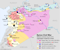
Map of the territorial control (Assad government, Islamic State/ISIS/ISIL, rebel, and Kurdish) in the Syrian Civil War as of August 2015
Map of IS Control in Syria, Aug. 2015
(click for subscriber article and map).

2014.10.06 A hardline religious militia, in control of the eastern city of Derna, pledged allegiance to the “Islamic State” group of Iraq and Syria. An “Islamic emirate” had already been declared in the town the previous month.

2014.10.29 Pro-Tobruk forces claimed to be in control of most of Benghazi, after weeks of renewed heavy fighting (ACLED).

2014.11.05-07 Libya Dawn-backed Tuareg fighters, with help from Misrata, captured the Shararah oil field in southwestern Libya from pro-Tobruk militias (ACLED).

2014.11.22 Haftar-backed fighters from the Tebu ethnic group drove Libya Dawn out of southern Libya’s Ubari region (ACLED). However, fighting would flare up again the next year between pro-Tobruk Tebu fighters and pro-Tripoli Tuareg militias.

2014.11.23 Tobruk-aligned fighters from Zintan reportedly captured the western mountain town of Kikla after more than a month of battles against other regional militias associated with Libya Dawn (ACLED).

2014.12.13 Omar al-Hassi’s Tripoli-based government backed a new Libya Dawn operation to capture the Ras Lanuf and Sidra oil terminals from Ibrahim Jathran’s militias, now allied with the al-Thani government in Tobruk.

2014.12.08-10 Forces of General Haftar’s Libyan National Army (LNA) captured two towns west of Zawiya, but Libya Dawn soon pushed them back again (ACLED).

2014.12.19 A Libya Dawn-oriented Misratan militia seized Brak airbase (but not the rest of the town), located in southern Libya (ACLED).

Part III: The War in 2015

2015.01.07 The “Islamic State” organization (IS) based in Iraq and Syria officially established a branch in Libya, after one militia in Derna declared allegiance to IS in October (ACLED).

2015.01.10 UN-backed negotiations to be held in Geneva regarding the conflict in Libya were announced to include representatives from the Tripoli parliament and the allied Libya Dawn militias as well as General Haftar’s Operation Dignity forces.

2015.01.16 Libya Dawn (GNC) declared a ceasefire with Tobruk-aligned forces in the lead-up to peace talks in Geneva the following week.

2015.01.22 Forces allied with General Haftar and the Tobruk government seized the central bank in Benghazi.

2015.01.24 Ansar al-Sharia leader Mohamed al-Zahawi was killed in Benghazi clashes.

2015.01.27 IS-affiliated gunmen attacked the Corinthia Hotel in Tripoli; fighters loyal to the GNC Tripoli government fought back against the gunmen.

2015.02.04 An oil field in Mabrouk, one of Libya’s largest, was stormed by alleged IS militants.

2015.02.08 IS-aligned fighters claimed to have captured Nawfaliya, a town near Sidra oil terminal, in fighting with Libya Dawn forces. Over the next few months, control the town would apparently go back and forth between the two groups (ACLED).

2015.02.11 UN-backed peace talks were held in Ghadames, with the aim of forming a unified government between the General National Congress of Tripoli and the Tobruk-based House of Representatives.

2015.02.11-13 Fighters claiming to be IS members moved into the city of Sirte, seizing parts of the city without resistance (ACLED).

2015.02.20 IS-affiliated militants detonated car bombs in Qubbah, in what was believed to be retaliation to airstrikes by the Egyptian military on nearby IS-controlled Derna.

2015.03.02 The Tobruk parliament appointed General Haftar the official commander of the Libyan armed forces.

2015.03.03 The Mabrouk and Bahi oil fields were reported seized by religious extremist fighters, possibly from IS.

2015.03.06 Representatives from Tobruk and Tripoli met in Morocco for another round of UN-brokered peace talks, with additional sessions planned in Algeria and Belgium.

2015.03.11 It was reported that fighters from Haftar’s pro-Tobruk army had captured several towns just south and west of Tripoli (ACLED).

2015.03.24 Islamic State militants attacked government soldiers in Sirte and Benghazi, killing fighters loyal to both the Tripoli government and the internationally recognized government in Tobruk.

2015.03.27 Libya Dawn fighters loyal to the GNC government in Tripoli reportedly withdrew from positions near Ras Lanuf and Sidra oil ports, which they had been trying to capture from the Tobruk-aligned oil security forces. They initially claimed to still be in control of nearby Bin Jawad, but the Tobruk government was soon reported to have retaken the town after Libya Dawn fighters withdrew.

2015.04.01 Libya Dawn aircraft reportedly bombed an airport in Zintan.

2015.04.05 Pro-Tobruk forces claimed control of western town of Aziziyah, after two days of clashes with Libya Dawn militias (ACLED).

2015.04.12 Unidentified militants attacked South Korea’s embassy in Tripoli.

2015.04.13 IS-affiliated militants attacked the Moroccan embassy in Tripoli.

2015.04.18 Libya Dawn forces in two suburbs of Tripoli confronted General Haftar sympathizers there.

2015.04.22 Libya Dawn militias withdrew from the town of Zahra, near Tripoli, after clashes with Haftar’s LNA forces (ACLED).

2015.05.29 IS militants seized the airport in Sirte (Ghardabiya Airbase).

2014.05.31 IS fighters reportedly took control of Hawara town near Sirte after local leaders surrendered to a week-long siege (ACLED).

2015.06.09 IS fighters captured a power station in Sirte, virtually completing their control of the town (ACLED).

2015.06.09-11 The forces of IS were pushed out of Derna after a falling-out with other hardline religious militias.

2015.07.05 Hardline militia Ansar al Sharia captured a neighborhood in Benghazi from Haftar’s Tobruk-aligned Operation Dignity forces.

2015.07.12 IS fighters captured Wushka village in a push towards Libya Dawn-dominated Misrata (ACLED).

2015.07.27 A spokesperson for the Tobruk government claimed that “all the oil fields” in Libya were under the control of his government’s military. No specific information was given on the Mabrouk and Bahi fields, which were captured by likely IS fighters in March.

2015.07.31 Shura Council forces in Derna forced IS fighters out of an area just south of Derna.

2015.08.01 Fighting was reported between the Tobruk-loyal military and IS forces in Ajdabiya (ACLED).

2015.08.08-09 Shura Council religious hardliners from Derna – reportedly with air support from the Tobruk-based military – battled with IS fighters just south of the city (ACLED).

2015.08.13 Sudanese rebels groups from that country’s Darfur region were alleged to be fighting on the side of General Haftar in Kufra (ACLED).

2015.08.10-15 A local group in Sirte, cheered on by ultraconservative religious leaders, rose up against IS control of the city, leading to several days of fighting (ACLED).

2015.08.14-15 IS forces claimed to have captured an army post in Benghazi, but were repelled the next day by Haftar’s army (ACLED).

Following this story? View all Libya maps on PolGeoNow.

Graphic of Libyan flag is in the public domain (source).
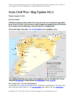
Syria Civil War Map: January 28, 2014 (#12.1) (Premium)

There are newer versions of this map available. To see them, view all Syria updates.

Map of fighting and territorial control in Syria's Civil War (Free Syrian Army rebels, Kurdish groups, Al-Nusra Front, ISIS/ISIL and others), updated to January 28, 2014. Includes recent locations of conflict between ISIS and other rebel groups, including Raqqa, Jarabulus, Manbij, Kafranbel, and others.

Download PDF
buy

(Subscribe via Paypal)

PolGeoNow presents our first premium Syria map, part of our new more frequent updates for the Syrian Civil War! Since last month a major struggle has emerged between ISIS extremists and a coalition of other rebel groups, with several key towns changing hands. See the updated map and briefing in this premium report. Buy now (US$5.99).

Members click here to proceed to article and map

NOT A MEMBER YET? SUBSCRIBE HERE!

Syria Civil War Map: December 2013 (#12)

There are newer versions of this map available. To see them, view all Syria updates.

In addition to updates on the situation, our updated Syria control map now distinguishes the territory of extremist groups ISIS and Al-Nusra from that of Free Syrian Army or mixed rebel coalitions. (To see other maps in this series, view all Syria updates.)

Tired of waiting months for Syria map updates and briefings? Subscribers to our premium member service will soon begin seeing much more frequent Syria control updates. Don’t miss out – sign up now!

Map of fighting and territorial control in Syria's Civil War (Free Syrian Army rebels, Kurdish groups, Al-Nusra Front, ISIS/ISIL and others), updated for December 2013. Includes recent locations of conflict and territorial control changes, Al-Safira, Khanaser, Maaloula, Qara, Nabek, and .
Area of fighting and territorial control in Syria’s civil war, updated for December 2013. Map by Evan Centanni, starting from this blank map by German Wikipedia user NordNordWest. License: CC BY-SA

Premium members click here to view this article in the ad-free members area. Not a member yet? Subscribe now!

Al-Nusra and the ISIS
In addition to updates on the situation since our previous Syria war map, this edition of the map also shows which cities are controlled primarily by religious extremist groups the Al-Nusra Front and the Islamic State of Iraq and Syria (ISIS) (also translated from Arabic as ISIL, the Islamic State of Iraq and the Levant). While these groups share many of their goals with the Free Syrian Army and other rebel groups fighting the Assad government, and in many cases still cooperate strategically with those groups, they are increasingly emerging as a separate bloc in the multi-sided conflict.

Though most of the rebels in Syria are Sunni Muslims, many of them hope to establish a secular democracy with representation for all Syrians. Al-Nusra and ISIS, on the other hand, base their entire organizations around a violent extremist religious ideology. Both are affiliates of Al Qaeda, and have claimed responsibility for many of the most brutal atrocities committed during the war. Unlike the Free Syrian Army (FSA) and other rebel groups operating in the country, which are apparently made up mostly of native Syrians, Al-Nusra and ISIS include large proportions of foreign fighters. In fact, ISIS is the same group once known as Al-Qaeda in Iraq, and has been part of the insurgency in that country since soon after the Iraq War began in 2003.

Flag of Syria under the current governmentCountry Name:  
• Syria (English)
• Sūriyya/Sūryā (Arabic)
Official Name:  
• Syrian Arab Republic (English)
• al-Jumhūriyyah al-‘Arabīyah  as-Sūriyyah (Arabic)
Capital: Damascus

These two groups have emerged as the most powerful and effective fighting forces in Syria, and are responsible for many of the rebel victories over the last year and beyond. And although the Syrian rebels have rarely if ever been united under a single command, Al-Nusra and ISIS have increasingly stood out not only for their radicalism, but also for their direct conflict with the Free Syrian Army and other groups, often seizing towns from the other rebels by force. Now, enough information is finally available for us to show these groups separately on the territorial control map.

Although most rebel territory in Syria is still occupied by mixed rebel coalitions or FSA affiliates, several cities and towns are now known to be primarily under ISIS and/or Al-Nusra control. ISIS’s area of control is mostly in the northwest, stretching from provincial capital Raqqah to key towns in Aleppo and Idlib provinces, and all the way to the far western rebel outpost of Salma in Latakia province. Al-Nusra, though present across most of the country, is especially known to control territory in the east, where it has held the oil town of Shadadeh for some months now. It has also recently captured the Al-Omar Oil Field, Syria’s largest. Al-Nusra has made headlines in Western countries recently by repeatedly harassing and occupying the historic Christian town of Maaloula north of Damascus.

Government Advances in the North
The largest change in territorial control since our August Syria map update has been the army’s recapture of Al-Safira, a satellite city of Aleppo which is also the location of a major chemical weapons stockpile. Rebels had captured the city early this year, but government forces took it back last month as part of a campaign to reopen the back road from Homs to Aleppo. The nearby town of Khanaser was recaptured one month earlier, after having fallen into rebel hands just after our last update in August.

Ariha, an important town in the northwestern Idlib province, was also recaptured by government forces in early September, after switching back and forth in control more than once over the course of the war.

Damascus and Surroundings
Syria’s capital city of Damascus has continued to be a focal point in the war, with rebel and government forces fighting fiercely for control of its many suburbs (map). Meanwhile, one of the most active fronts in recent weeks has been the area between Damascus and Homs, where the Syrian military and its ally Hezbollah from Lebanon have been trying hard to root rebels out from a mountainous region along the border. In addition to the Christian town of Maaloula mentioned earlier, rebel possessions in this region also include the town of Yabroud, with the government having captured Qara last month and Nabek just a week ago.

The South and East
The southern Syrian province of Daraa has continued to be a major front for fighting over the last several months, with a coalition of various rebel groups capturing the border crossing next to Daraa city in October. Meanwhile, in far northeastern Hasakah, Kurdish militias have seized the Yarabiya border crossing from a coalition of ISIS, Al-Nusra, and other groups. This is the main border crossing into Iraq from northern Syria, though the Kurdish National Council had previously set up a temporary crossing to the north. The area across this border is part of Iraq’s official autonomous Kurdistan Region.

Also in Kurdish-majority Hasakah province, this edition of the map has been adjusted to reflect the fact that the city of Al-Hasakah itself is apparently under partial Kurdish control.

Graphic of the Syrian flag is in the public domain (source).

Syria Civil War Map: August 2013 (#11)

There are newer versions of this map available. To see them, view all Syria updates.

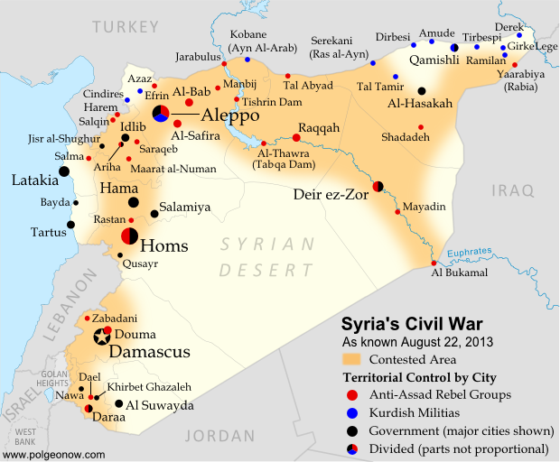
Syria’s civil war has continued to rage through the summer, with small changes in territorial control and the area of fighting. Here’s the updated conflict map, plus a summary of recent territorial changes and other developments.

Map of fighting and territorial control in Syria's Civil War (Free Syrian Army rebels, Kurdish groups, Al-Nusra Front and others), updated for August 2013. Includes recent locations of conflict and territorial control changes, including Salma (Latakia), Nawa (Daraa), and Ras al-Ayn (Hasakah).
Area of fighting and territorial control in Syria’s civil war, updated for August 2013. Map by Evan Centanni, starting from this blank map by German Wikipedia user NordNordWest. License: CC BY-SA

Latest Fronts
Over the last two months since our previous Syria war map, fighting increased in three different corners of the country. In the northwest, rebels pushed farther into the coastal province of Latakia, a stronghold of President Bashar al-Assad and his native Alawite ethnic group. The rebel forces captured and briefly held several Alawite villages in the mountains before being pushed back to their base in Salma.

Meanwhile, fighting has heated up in the already contested Daraa province of southwestern Syria. Most notably, the rebels stormed the major town of Nawa in July, before losing it to the Syrian army again this month. In the country’s opposite corner, the far northeastern province of Hasakah, Kurdish militias finally seized full control of Serekani (Arabic name: Ras al-Ayn) from religious extremist rebels who had been fighting for the town since last year. Apparently in response, the extremists have pushed farther into Kurdish territory elsewhere in the province.

Flag of Syria under the current governmentCountry Name:  
• Syria (English)
• Sūriyya/Sūryā (Arabic)
Official Name:  
• Syrian Arab Republic (English)
• al-Jumhūriyyah al-‘Arabīyah  as-Sūriyyah (Arabic)
Capital: Damascus

Fighting in Major Cities
Syria’s three largest cities have remained battlefields over the past months, with number-one metropolis Aleppo still bitterly divided between the government, the rebels, and Kurdish groups. The Syrian army has made further inroads into Homs, and now controls most but not all of the key central city.

While central Damascus remains mostly out of reach for the rebels, fierce battles have continued to be waged over the capital city’s many suburbs (see a map of rebel and government control in the city from two weeks ago).

Broad Trends
An expert quoted in a New York Times article last month estimated that Syria’s rebel groups now control 60-70% of the country’s land, but only 40% of the population, due to their greater success at controlling rural areas than holding major cities.

Meanwhile, the opposition remains as disorganized as ever, having proved unable to form a national-level interim government for the rebel-held areas. But the starkest sign of disunity between the various anti-Assad groups has been the breakout of major fighting between the secular-minded Free Syrian Army (FSA) rebels and the religious extremists of the Nusra Front and the ISIS (“Islamic State of Iraq and Syria”). The latter groups have emerged as the strongest rebel force in many areas of Syria, driving the FSA out of Raqqah city as part of their rise in power across the country’s north and east.

Small Adjustments
This edition of the map returns to showing Ariha, a major town in Syria’s northwestern province of Idlib whose status had been unclear for many months. Recent reports indicate that it is divided between rebel and government control. In central Syria, the war has now reached the previously peaceful city of Salamiya, which was shelled by rebel forces two weeks ago.

Similar Articles:
Syria Civil War Map: June 2013 (#10)
Mali Conflict Map: National Territory Reunited
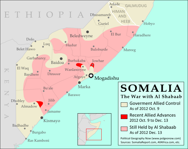
War in Somalia: Map of Al Shabaab Control

Graphic of the Syrian flag is in the public domain (source).

Egypt Suspended from African Union

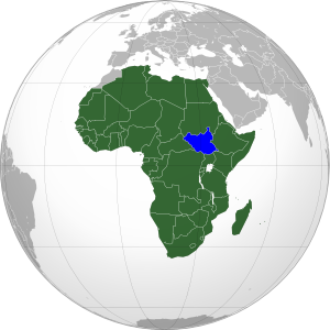
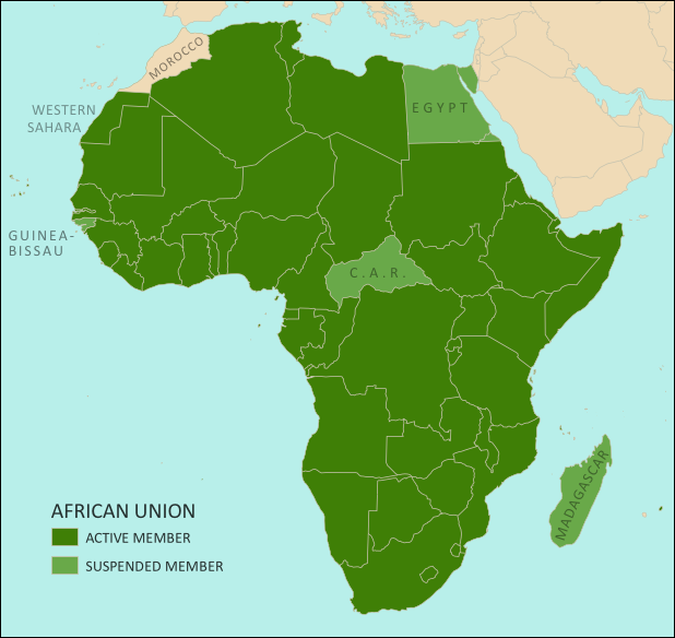
Map of the African Union, including active and suspended members, updated for the July 2013 suspension of Egypt (colorblind accessible).
The African Union. Map by Evan Centanni, from this blank map by Eric Gaba. License: CC BY-SA

Flag of the Arab Republic of Egypt Country Name:  
• Egypt (English)
Miṣr (Arabic)
Official Name:  
• Arab Republic of Egypt (English)
• Ǧumhūriyyat Miṣr al-ʿArabiyyah (Arabic)
Capital: Cairo

Article by Evan Centanni

African Union Suspends Egypt
Egypt, the third most populous country in Africa, was suspended last weekend from that continent’s regional organization, the African Union (AU). The suspension comes after months of unrest in the country, in which massive popular protests led to the military overthrow of the government last week. The suspension is being taken very seriously by the parties involved.

The AU’s Peace and Security Council typically suspends member countries when they experience coups or other breakdowns of constitutional rule. Egypt joins three other African countries which are also currently suspended for similar incidents: Madagascar, Guinea-Bissau, and the Central African Republic (CAR) (see the links for information on each country’s constitutional crisis).

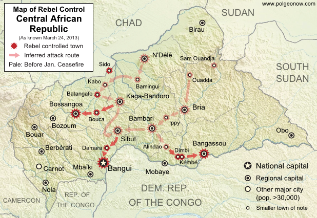
See Also: Rebel Takeover of Central African Republic (map)

What is the African Union?

Flag of the African Union (AU)Organization Name:  
• African Union (English)
• al-Āthḥād al-’Āfrīqī (Arabic)
• Union africaine (French)
• União Africana (Portuguese)
• Unión Africana (Spanish)
• Umoja wa Afrika (Swahili)  
Launched: 2002 in Durban, South Africa
Headquarters: Addis Ababba, Ethiopia
Website: www.au.int

Formed in 1999-2002 to replace the earlier Organization of African Unity (OAU), the AU is an intergovernmental organization which works on increasing cooperation, stability, and development within the continent of Africa. It has a secretariat based in Addis Ababa, Ethiopia, though many of its most important decisions are made during annual summits of the continent’s national leaders.

Every UN-recognized country in Africa is a member of the African Union except for Morocco, which withdrew from the OAU in 1984 after the organization chose to admit the partially recognized state of Western Sahara, a disputed territory which Morocco claims and largely occupies. The only other parts of Africa not represented in the AU are a few groups of offshore islands controlled by European countries, as well the small Spanish enclaves in North Africa. The breakaway Republic of Somaliland is not a member, but is considered by the AU to be part of Somalia.

Low-resolution graphic of the African Union flag is displayed under fair use principles (source).

Related Articles:

Croatia Joins EU, Leaves CEFTA

Syria Civil War Map: June 2013 (#10)

There are newer versions of this map available. To see them, view all Syria updates.

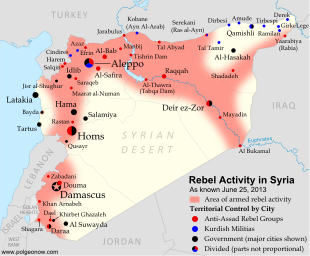
Since March, large-scale violence has continued in Syria. Despite this, no major cities have changed hands – yet there have been important changes to control of smaller towns in two different regions. Here’s the updated conflict map, plus a summary of recent territorial changes.

Map of rebel activity and control in Syria's Civil War (Free Syrian Army, Kurdish groups, Al-Nusra Front and others), updated for June 2013. Includes recent locations of conflict and violence, including the Qusayr, Golan Heights, Daraa, Dael, and Baida.
Activity and cities held by rebels and other groups in Syria, updated for June 2013. Map by Evan Centanni, starting from this blank map by German Wikipedia user NordNordWest. License: CC BY-SA

Golan Heights Fighting
Soon after our last update, rebel groups continued making small gains in Syria’s far southeast. In mid-March, they captured a military intelligence compound in the town of Shagara, and three days later the same group seized the town of Khan Arnabeh a bit to the north. Both towns lie close to the Golan Heights, a disputed territory controlled by Israel.

A narrow strip of land on the Syrian side of the Golan Heights ceasefire line has been demilitarized under the protection of U.N. peacekeepers since 1973, but even this area has seen fighting since late last year. Rebels in the zone briefly took control of the border crossing with Israel early this month, part of a series of events that has put the peacekeeping mission’s future in jeopardy.

Rebel Gains in Daraa
Soon after taking Khan Arnabeh, the same rebel group achieved yet another major victory: the capture of a major air defense base just east of the southern Syrian city of Daraa. Soon they and other rebel groups had effective control of all border crossings with Jordan.

By the end of the month, rebel forces were also in control of Dael, an important town north of Daraa city. It was only in May that the Syrian army began getting its foothold back outside of Daraa, seizing the town of Khirbet Gazaleh near Dael.

Flag of Syria under the current governmentCountry Name:  
• Syria (English)
• Sūriyya/Sūryā (Arabic)
Official Name:  
• Syrian Arab Republic (English)
• al-Jumhūriyyah al-‘Arabīyah  as-Sūriyyah (Arabic)
Capital: Damascus

Government Takes Qusayr
The more important change in control came early this month, when the Syrian government and allied forces captured Qusayr after a long and difficult battle. Qusayr is a strategic town between the city of Homs and the border with Lebanon, and saw prolonged fighting earlier in the war before coming under rebel control a year ago. Since Qusayr’s recapture, other nearby towns have also been seized by the government.

Hezbollah and Lebanon
In the battle for Qusayr, Syria’s army received major military support from Hezbollah, a Shiite militia from Lebanon which has long supported President Bashar al-Assad. After that victory, Hezbollah has become more overtly involved in the fighting within Syria. Meanwhile, Lebanon is being slowly dragged into its neighbor’s civil war, with one Lebanese town even coming under attack from the Syrian military two weeks ago.

Battles Continue in Major Cities
Syria’s biggest population centers continue to be centers of intense fighting as well, with Aleppo still divided between multiple groups (see a collaborative map of control) and once-rebel-dominated Homs now reportedly 80% government-controlled. At the same time, the capital city of Damascus continues to see heavy back and forth fighting in its suburbs, and in recent months rebels have even begun moving into the city itself.

Activity on the Coast
Last month, the town of Bayda near Syria’s Mediterranean coast became infamous for a brutal massacre committed by government or allied forces against Sunni civilians, some of whom had been rebel sympathizers (rebels were also accused of a sectarian massacre in a few weeks later). The Bayda massacre was reportedly a response to an attack by local rebels on a bus carrying pro-government militiamen, a rare and possibly unprecedented instance of armed rebel activity Syria’s coastal region. This area, which is the traditional homeland of President Assad’s minority Alawite sect, has been so far spared from rebel-on-army fighting, though it has been the scene of unarmed protests violently suppressed by the government.

Adjustments to the Map
Two adjustments have been made to the Syria control map in this update which do not necessarily reflect actual changes to the situation since last time. First, the city of Hama has been colored all black rather than black and red, to reflect the fact that there has recently been little evidence of significant rebel control within the city (however, back-and-forth fighting continues outside the city in Hama province).

The second adjustment is to Zabadani, in the mountains between Damascus and the border with Lebanon. This town has been contested since early in the war, sometimes falling under rebel control and other times to the government. The most recent information suggests that rebels have nearly complete control of the town itself, despite being surrounded by government forces.

Related Articles:

Graphic of the Syrian flag is in the public domain (source).

Syria Uprising Map: March 2013 (#9)

There are newer versions of this map available. To see them, view all Syria updates.

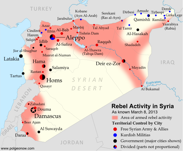
Syria’s civil war has continued to spread eastward across the country, with rebels taking two major towns over the last month. Below is the updated conflict map, plus a summary of recent territorial changes.

Map of rebel activity and control in Syria's Civil War (Free Syrian Army, Kurdish groups, Al-Nusra Front and others), updated for March 2013. Includes recent locations of conflict, including Raqqa, Al-Safira, Al-Hasakah, and Tabqa Dam.
Activity and cities held by rebels and other groups in Syria, updated for March 2013. Map by Evan Centanni, starting from this blank map by German Wikipedia user NordNordWest. License: CC BY-SA

Eastward to Raqqah
Since our last Syria map update, rebel forces have continued to move southeast from Aleppo (where fighting still rages), last month taking over the Tabqa hydroelectric dam. It was soon reported that they controlled the neighboring town of Thawrah as well. (“Tabqa” and “Thawrah” are actually two names for the same place; the latter is a more recent official name which means “revolution” in Arabic).

This week, the rebels reached Raqqah, apparently seizing nearly the whole city and capturing the provincial governor. This gives them almost complete control of an entire province, and is the first time they have held a provincial capital since losing Idlib city a year ago. It also effectively connects the two fronts of the war, with rebels now mostly in control of a stretch running all the way from Aleppo in the northwest to Al Bukamal in the southeast.

Flag of Syria under the current governmentCountry Name:  
• Syria (English)
• Sūriyya/Sūryā (Arabic)
Official Name:  
• Syrian Arab Republic (English)
• al-Jumhūriyyah al-‘Arabīyah  as-Sūriyyah (Arabic)
Capital: Damascus

Rebel and Kurdish Groups in the Northeast
Even as rebel forces moved east from Aleppo, another group struck out northwest from the Deir ez-Zor area, taking over the town of Shadadeh in Al-Hasakah province. This northeasternmost province is a major oil-producing region, but further conquests may come up against resistance from Kurdish militias, whose people form a large percentage of the population.

Indeed, Kurdish groups have continued to consolidate their power in Syria’s far northeast, seizing the town of Ramilan this week, and reportedly occupying most of Al-Hasakah’s oil fields. The Kurdish militias are not officially aligned with either side in the war, usually claiming to oppose the government, but keeping a wary eye on the rebels at the same time.

Last weekend, another battle was going on quite close to Ramilan. In what became a small international incident, rebels fought government forces for control of the northeastern border crossing to Iraq. According to some reports, the rebels gained control of Yaarabiya, the town on the Syrian side of the border; the crossing is also known as Rabia, after the town on the Iraqi side.

Fighting in Syria’s West
Also last month, rebels moved into Al-Safira, a major town just outside of Aleppo. They were soon reported to control of the streets, though fighting was ongoing against government forces just outside the town. In December, just after our last map update, there was also a major campaign near Hama, in which rebels took control of various small towns and villages north of the city, but lost several of them again within a few weeks.

The Al-Nusra Front
It is worth mentioning that rebel victories in Syria’s civil war have increasingly been attributed not to the Free Syrian Army, but to its ally the Al-Nusra Front (also known as Jabhat al-Nusra). This militant group, known for a long list of bombings as well as battles, is made up of religious fundamentalists who envision an Islamic state to replace the current Syrian government. The Al-Nusra Front has played a leading role in Al-Safira and Shadadeh in particular, succeeding partly through the skills of well-trained foreign fighters from other Arab countries like Libya, Iraq, and Saudi Arabia. It is suspected of ties with Al Qaeda.

Related Articles:

Central African Republic: Map of Rebel Advance to Capital

Graphic of Syrian flag is in the public domain (source).
Syria Uprising Map: December 2012 (#8)

There are newer versions of this map available. To see them, view all Syria updates.

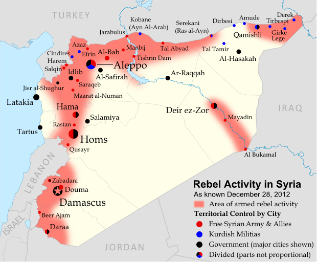
 In recent months, Syria’s rebels have continued to tip the balance of the country’s civil war toward their favor, with various local victories and a few further extensions of their territorial control. Below is the updated conflict map, plus a summary of recent territorial changes.

Map of rebel activity and control in Syria's Civil War (Free Syrian Army, Kurdish groups, and others), updated for December 2012. Includes recent locations of conflict, including Salqin, Harem, Beer Ajam, Tishrin Dam, and Ras al-Ayn.
Activity and cities held by rebels and other groups in Syria, updated for December 2012. Map by Evan Centanni, starting from this blank map by German Wikipedia user NordNordWest. License: CC BY-SA

Rebels Consolidate Control in Northwest
Soon after our last update, the rebels of the Free Syrian Army announced the capture of Salqin in the northwestern province of Idlib. This was the first step in a push to close the Syrian government’s last pocket of control along the Turkish border in Idlib – a goal reached just this Tuesday when the rebels finally stormed the loyalist border town of Harem. This leaves Idlib city and the town of Jisr al-Shughur as the Syrian army’s last major strongholds in the northern part of the province.

Flag of Syria under the current governmentCountry Name:  
• Syria (English)
• Sūriyya/Sūryā (Arabic)
Official Name:  
• Syrian Arab Republic (English)
• al-Jumhūriyyah al-‘Arabīyah  as-Sūriyyah (Arabic)
Capital: Damascus

Eastward Expansion and Rebels vs. Kurdish Militias
Meanwhile, rebel groups have extended their control further into Al-Raqqah and Al-Hasakah provinces in Syria’s northeast. On November 8th, they reached the Kurd-dominated town of Serekani (known in Arabic as Ras al-Ayn), where they pushed out what government soldiers still remained after a Kurdish takeover earlier this year.

However, this victory was followed by several weeks of clashes between the rebels and local Kurdish militias. Much of the fighting was initiated by Islamic extremist factions among the rebels, though relations are already tense enough between Kurdish groups and the Arab-dominated Free Syrian Army.

Kurdish militia units took the events in Serekani as a cue to finish ridding other Kurdish towns of government troops, some of whom had previously been allowed to remain inside their bases despite no longer controlling the towns. These efforts also resulted in one new town, Tal Tamir, falling into Kurdish hands.

Also in the country’s northeast, rebel forces overran Tishrin Dam on the Euphrates River in late November. This hydro-electric dam is an important source of energy for northern Syria, and also serves as a key crossing on the main road from Aleppo to Al-Raqqah.

Renewed Fighting in Damascus and the Golan Heights
Although the Syrian capital itself remains mostly under government control, rebel activity in the surrounding suburbs has redoubled in recent months, with neighborhoods outside the city limits believed to form a patchwork of government, rebel, and undetermined control. Douma, the next largest city in Damascus’s metropolitan area, is again a rebel stronghold.

Farther to the southwest, fighting has broken out in the Golan Heights region. Most of this disputed territory has been controlled by Israel since 1967, but a thin strip on the Syrian side is patrolled as a demilitarized zone by U.N. peacekeeping forces. However, last month Syrian rebels began establishing themselves in the zone, capturing local villages such as Beer Ajam. Government forces ignored the strip’s demilitarized status and entered with tanks to combat the rebels, leading to exchanges of fire with the Israeli military after Syrian shells flew over the international border.

Graphic of Syrian flag is in the public domain (source).
Syria Uprising Map: October 2012 (#7)

There are newer versions of this map available. To see them, view all Syria updates.

Syria’s civil war has raged on over the last two months, with neither side gaining the upper hand. Death and destruction has been enormous, and territorial changes few, though not none. Read on for the rundown.

Map of rebel activity and control in Syria's Civil War (Free Syrian Army, Kurdish groups, and others), updated for October 2012
Activity and cities held by rebels and other groups in Syria, updated for October 2012. Map by Evan Centanni, starting from this blank map by German Wikipedia user NordNordWest. License: CC BY-SA

Rebel Gains in North

Since our last Syria update in August, the broadest change to territorial control has been the rebels’ eastward expansion from Aleppo into ar-Raqqah province, a region that had previously seen little fighting. Most notably, the Tal Abyad border crossing fell out of government hands on September 19. Starting early this month, attempts by government forces to take back Tal Abyad spiraled into low-intensity border clashes between Turkish and Syrian government forces after Syrian shells began crossing into the other country.

Flag of Syria under the current governmentCountry Name:  
• Syria (English)
• Sūriyya/Sūryā (Arabic)
Official Name:  
• Syrian Arab Republic (English)
• al-Jumhūriyyah al-‘Arabīyah  as-Sūriyyah (Arabic)
Capital: Damascus

Meanwhile, as the city of Aleppo remains divided (map), rebel forces have slowly fought their way to modest gains in neighboring Idlib province. On August 12, the fighters secured a new stretch of border villages west of Armanaz, and on the 16th they seized Maarat al-Numan, a strategic town located on the highway between Damascus and Aleppo.

Southern & Eastern Regions
Fighting still rages in the Damascus area as well, and it is sometimes impossible to keep track of the constant back and forth between the government and rebels. However, as of last week Douma, the largest city outside of the capital, was reportedly under control of the Free Syrian Army. In the east, they also hold Mayadin, a major eastern town with a bridge over the Euphrates River.

Fighting has also begun to spill over into the neighboring country of Lebanon, whose current government is seen as supportive of the Syrian regime. The country is among the Middle East’s most diverse, and many groups have sided instead with Syria’s rebels.

Syria Map: Corrections & Additions
As the situation in Syria is rapidly changing, and journalists inside the country are few, it can sometimes be difficult to keep up with the changes. As a case in point, it turns out that the town of Ariha in Idlib province was taken back by the Syrian army a week before our August 2012 Syria update, though that map still indicated that it was rebel-held.

Two more towns have also been added to the map since last time: Zabadani northeast of Damascus was a key rebel stronghold early in the war before falling to the government, and since at least this August it is again largely controlled by the Free Syrian Army rebels. East of Aleppo, Manbij is one of the country’s largest rebel-administered towns, after government forces pulled out on July 19.

Graphic of Syrian flag is in the public domain (source).
Syrian Uprising Map: August 2012 (#6)

There are newer versions of this map available. To see them, view all Syria updates.

Political Geography Now presents the sixth update to our map of rebel control in Syria’s civil war. Since last month, battle has erupted in the country’s largest city, Kurds have formed a parallel government in northern towns, and more. Read on for a rundown of recent events.

Map of rebel control in Syria's Civil War (Free Syrian Army, Kurdish groups, and others), updated for August 2012
Activity and cities held by rebels and Kurdish groups in Syria, updated August 16, 2012. Map by Evan Centanni, starting from this blank map by German Wikipedia user NordNordWest. License: CC BY-SA

Battles for Damascus & Aleppo
Not long after our last Syria update, the anti-government Free Syrian Army moved into the capital city of Damascus for the first time, taking advantage of the chaos sown by their shocking assassination of the country’s defense minister and two other top security officials. But after claiming control of some neighborhoods for several days, the rebels were eventually driven back into the suburbs.

Yet even as fighters were expelled from Damascus, the Free Syrian Army began moving into Aleppo, Syria’s largest city. By the end of the month, the previously quiet northern metropolis was facing widespread rebel control in “an arc that [covered] eastern and southwestern districts”. Al Bab, one of Aleppo’s two largest satellite cities, also fell to rebel forces at the beginning of August.

Flag of Syria under the current governmentCountry Name:  
• Syria (English)
• Sūriyya/Sūryā (Arabic)
Official Name:  
• Syrian Arab Republic (English)
• al-Jumhūriyyah al-‘Arabīyah  as-Sūriyyah (Arabic)
Capital: Damascus

Rebels Capture Border Crossings
Meanwhile, the armed opposition also launched a takeover of several major crossings along the Syrian border. On the northern boundary between Syria and Turkey, rebels took over Bab Al-Hawa crossing in Idlib province and the Bab Al-Salam and Jarabulus crossings in Aleppo province (“bab” means “gate” in Arabic).

On the eastern border with Iraq, an Iraqi official at one point claimed Syrian rebels controlled all border crossings; however, they later appeared to hold only the Al Bukamal (Abu Kamal) crossing in Deir ez-Zor province.

Kurdish Control in North

Also in July, Kurds in the north began taking control of Kurdish-populated areas. Militias serving the allied Kurdish Democratic Union Party (PYD) and Kurdish National Council (KNC) have so far seized at least nine towns (full list with sources) and parts of Qamishli, as well as two districts of Aleppo city.

These groups’ goal to create a Kurdish autonomous region in the north has alarmed Turkey, which has been fighting Kurdish rebels north of the border for years. So which side of the Syrian civil war are the Kurdish groups on? For now, they oppose the government; but relations with the Arab-dominated Free Syrian Army are tense, and President al-Assad has been accused of intentionally handing over areas to the Kurdish militias in order to keep out Turkey and the other rebels. 

Country in Chaos 

Flag of Syria's Democratic Union Party (PYD), a Kurdish group which now controls many Kurd-populated towns in northern Syria
Flag of the PYD, flown in Kurdish-controlled towns (public domain)

Syria’s northern Idlib province still forms the core of rebel territory (with northern Aleppo province now added), where anti-Assad groups govern most of the countryside and hold major towns such as Saraqeb, Armanaz, and Ariha. However, Deir ez-Zor in the east is also emerging as a power center for the opposition, which now claims to control 90% of the province, including “at least half” of its main city. 

Meanwhile the Syrian National Council (SNC), an opposition umbrella group, has already established unofficial relations with many of the world’s countries, and official diplomatic relations with eight of them. Most of those only acknowledge the SNC as “a legitimate representative” of the Syrian people; but the rebels-turned-leaders of Libya go further, recognizing the Syrian opposition group as the country’s “sole legitimate government”. 

Meanwhile, the Syrian regime has been suspended from the Organization of Islamic Cooperation (OIC), a group including most of the world’s Muslim countries. In the Muslim world, international opposition to al-Assad’s Syrian government has been led by Saudi Arabia (a Sunni-majority country), while support has come mainly from Iran (a Shiite-majority country). Syria’s President Bashar al-Assad belongs to a minority Shiite sect (the Alawites), while the majority of Syrians, including most of the rebels, are Sunnis.

Graphic of Syrian flag is in the public domain (source).