
There are newer versions of this map available. To see them, view all Syria updates.
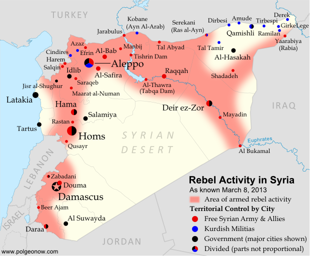
Syria’s civil war has continued to spread eastward across the country, with rebels taking two major towns over the last month. Below is the updated conflict map, plus a summary of recent territorial changes.
 |
|
Activity and cities held by rebels and other groups in Syria, updated for March 2013. Map by Evan Centanni, starting from this blank map by German Wikipedia user NordNordWest. License: CC BY-SA
|
Eastward to Raqqah
Since our last Syria map update, rebel forces have continued to move southeast from Aleppo (where fighting still rages), last month taking over the Tabqa hydroelectric dam. It was soon reported that they controlled the neighboring town of Thawrah as well. (“Tabqa” and “Thawrah” are actually two names for the same place; the latter is a more recent official name which means “revolution” in Arabic).
This week, the rebels reached Raqqah, apparently seizing nearly the whole city and capturing the provincial governor. This gives them almost complete control of an entire province, and is the first time they have held a provincial capital since losing Idlib city a year ago. It also effectively connects the two fronts of the war, with rebels now mostly in control of a stretch running all the way from Aleppo in the northwest to Al Bukamal in the southeast.
 Country Name: Country Name: • Syria (English) • Sūriyya/Sūryā (Arabic) Official Name: • Syrian Arab Republic (English) • al-Jumhūriyyah al-‘Arabīyah as-Sūriyyah (Arabic) Capital: Damascus |
Rebel and Kurdish Groups in the Northeast
Even as rebel forces moved east from Aleppo, another group struck out northwest from the Deir ez-Zor area, taking over the town of Shadadeh in Al-Hasakah province. This northeasternmost province is a major oil-producing region, but further conquests may come up against resistance from Kurdish militias, whose people form a large percentage of the population.
Indeed, Kurdish groups have continued to consolidate their power in Syria’s far northeast, seizing the town of Ramilan this week, and reportedly occupying most of Al-Hasakah’s oil fields. The Kurdish militias are not officially aligned with either side in the war, usually claiming to oppose the government, but keeping a wary eye on the rebels at the same time.
Last weekend, another battle was going on quite close to Ramilan. In what became a small international incident, rebels fought government forces for control of the northeastern border crossing to Iraq. According to some reports, the rebels gained control of Yaarabiya, the town on the Syrian side of the border; the crossing is also known as Rabia, after the town on the Iraqi side.
Fighting in Syria’s West
Also last month, rebels moved into Al-Safira, a major town just outside of Aleppo. They were soon reported to control of the streets, though fighting was ongoing against government forces just outside the town. In December, just after our last map update, there was also a major campaign near Hama, in which rebels took control of various small towns and villages north of the city, but lost several of them again within a few weeks.
The Al-Nusra Front
It is worth mentioning that rebel victories in Syria’s civil war have increasingly been attributed not to the Free Syrian Army, but to its ally the Al-Nusra Front (also known as Jabhat al-Nusra). This militant group, known for a long list of bombings as well as battles, is made up of religious fundamentalists who envision an Islamic state to replace the current Syrian government. The Al-Nusra Front has played a leading role in Al-Safira and Shadadeh in particular, succeeding partly through the skills of well-trained foreign fighters from other Arab countries like Libya, Iraq, and Saudi Arabia. It is suspected of ties with Al Qaeda.
Related Articles:
 |
 |
 |
Graphic of Syrian flag is in the public domain (source).
Can you make an animated map timeline?
Something like that but more polished?
Hi Khaled,
Thanks for the idea. We're looking into it, and might be able to post one in the near future.
Thanks for the update, Evan!
Yes please, I think will be very awesome to make a animated map timeline. Will be one of the firsts, because I didn't find others. Thanks!
You're welcome! 🙂
Here's one I made from the maps on this site: http://static.anonfiles.com/1363342984544.gif
Nice work! We're looking into the possibility of creating one with even nicer animation, or at least with consistent symbols. Stay tuned!
I searched Google specifically for this & was led here…Please compile such map ASAP & keep it updated. Many people are not willing to read every little detail about the progress (or lack of) armed parties!
Palmyra is in the news now… Can you put the name on the map?
I'll keep an eye on it for possible inclusion in the next update. Thanks.
Dael, in Daraa province, has been freed:
http://www.aljazeera.com/news/middleeast/2013/03/2013329142434763518.html
Thanks for the source!
Thanks for update, Evan. It's useful for me that live so far from Middle East, Indonesia.
You're welcome! I'm glad that people around the world can find these maps and articles useful! 🙂
Great Stuff, Evan. I like the idea of zoom maps of Damascus and Allepo. Might be easier to understand the ebb and flow of those areas.
Thanks for the compliment! I agree it would be nice to include close-up maps of Damascus and Aleppo, but it's just too difficult to get adequate information in that much detail. I don't know of any sources that are reliable, complete, and up-to-date in that regard. Some people on Wikipedia have made attempts, but I can't speak to how accurate or complete they are.
There is a close up map of the battle for Aleppo on wikipedia which is constantly updated, people are pretty good about putting their sources.
http://en.wikipedia.org/wiki/File:Battle_of_Aleppo_map.svg
I noticed that the far northeast is no longer shaded red, is that because the rebels are no longer fighting there and the Kurds are? or is it because the Kurds have the government basically pushed out and that fighting is no longer occurring?
Yes, I suppose I could use the same sources and compare it with that one. Or maybe just display or link to that actual map in the article.
The "area of activity" is very approximate, but yes – the general appearance of the situation is that the far northeast is pretty solidly under control of Kurdish militias and in some cases government forces which are not opposing them. The Kurdish groups generally don't welcome the Free Syrian Army (even if they share a hatred of Assad) or the Al-Nusra Front (which has actively attacked them in Serekani); and indeed there haven't been any recent reports of rebel activity or clashes there that I know of.
Maybe on your next map you could show this? Perhaps by shading it blue to show the Kurdish control?
That's a good idea. I'll probably do that on the next map if it seems appropriate. Thanks!
Here is another accurate map:
http://en.wikipedia.org/wiki/Cities_and_towns_during_the_Syrian_civil_war
I agree that's a pretty good map too – I check my map against that one when I'm doing an update. However, I don't trust its accuracy quite as much, since its sources don't always get cited. When I do find something interesting, I always search the news reports to double check it.
You may want to start distinguishing the different rebel groups or at the least edit the referece to "Free Syrian Army and Allies". The FSA is becoming increasingly marginalized by the expanding number of Islamist groups that in many areas are much more powerful and anything but 'allied'.
Yes some groups cooperate, but we are beginning to see a Syria that is tearing itself apart, become more fractured as this war drags on.
Extremists idiots enjoying watching their country getting destroyed… I couldn't care less but the problem is I am Lebanese and I know that once these retards finish with Syria they will come to us in Lebanon. This is what the Arab uprising is bringing to us, war, crimes, more retardness and all this shit in the name of the evil application of this religion Islam…
That's a good point. It's probably to difficult to determine (or even define) which group controls which area, but I can at least change the designation in the legend.
islam is peace. B ut peaple understand it differently
Update Qusayrn, Douma are 100% freed. Allepo and Dear AlZor are 75% freed. The FSA doesn't hold any city they don't control any government building except the ones near the Turkish border. There is a difference between being present and hiding in a city and controlling the city. The SAA however still controls all the large cities and most villages.
Al Jazeera exaggerates a lot of its news. It is a part of the conflict, keep in MIMD it is Qatar funded. The same goes to most US news channels. Are there any reliable news channels worthy of citation? maybe.Do I know any? its hard most are one sided in this conflict and the political maps are completely different in every different news source.
Sources? Qusair has changed hands – that's well documented – but not as sure about the others. Will be doing research for the updated map today and tomorrow.
The maps I've seen are actually fairly consistent, as are reports from various new agencies other than the ones directly controlled by the governments of Syria and allied countries (and even those sometimes agree on the essentials).
SAA is winning and that is a fact. I dont see how people can be on FSA side they are terrorists and buchers of innocent woman and kids.
i think the facts show on that website is not true. the ground reality is too much different against the map…this website is an american base and also manage by american .. may be funded by CIA.. i think Syrian army gain significance success against rebels from different factions around the world..insallah god help Muslims to unite and fight only against Israels and american..