Syria Uprising Map: December 2012 (#8)

There are newer versions of this map available. To see them, view all Syria updates.

 In recent months, Syria’s rebels have continued to tip the balance of the country’s civil war toward their favor, with various local victories and a few further extensions of their territorial control. Below is the updated conflict map, plus a summary of recent territorial changes.
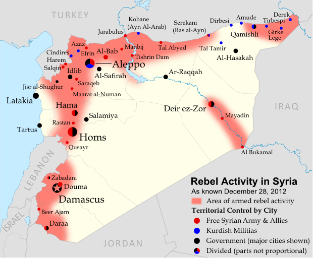
Map of rebel activity and control in Syria's Civil War (Free Syrian Army, Kurdish groups, and others), updated for December 2012. Includes recent locations of conflict, including Salqin, Harem, Beer Ajam, Tishrin Dam, and Ras al-Ayn.
Activity and cities held by rebels and other groups in Syria, updated for December 2012. Map by Evan Centanni, starting from this blank map by German Wikipedia user NordNordWest. License: CC BY-SA

Rebels Consolidate Control in Northwest
Soon after our last update, the rebels of the Free Syrian Army announced the capture of Salqin in the northwestern province of Idlib. This was the first step in a push to close the Syrian government’s last pocket of control along the Turkish border in Idlib – a goal reached just this Tuesday when the rebels finally stormed the loyalist border town of Harem. This leaves Idlib city and the town of Jisr al-Shughur as the Syrian army’s last major strongholds in the northern part of the province.

Flag of Syria under the current governmentCountry Name:  
• Syria (English)
• Sūriyya/Sūryā (Arabic)
Official Name:  
• Syrian Arab Republic (English)
• al-Jumhūriyyah al-‘Arabīyah  as-Sūriyyah (Arabic)
Capital: Damascus

Eastward Expansion and Rebels vs. Kurdish Militias
Meanwhile, rebel groups have extended their control further into Al-Raqqah and Al-Hasakah provinces in Syria’s northeast. On November 8th, they reached the Kurd-dominated town of Serekani (known in Arabic as Ras al-Ayn), where they pushed out what government soldiers still remained after a Kurdish takeover earlier this year.

However, this victory was followed by several weeks of clashes between the rebels and local Kurdish militias. Much of the fighting was initiated by Islamic extremist factions among the rebels, though relations are already tense enough between Kurdish groups and the Arab-dominated Free Syrian Army.

Kurdish militia units took the events in Serekani as a cue to finish ridding other Kurdish towns of government troops, some of whom had previously been allowed to remain inside their bases despite no longer controlling the towns. These efforts also resulted in one new town, Tal Tamir, falling into Kurdish hands.

Also in the country’s northeast, rebel forces overran Tishrin Dam on the Euphrates River in late November. This hydro-electric dam is an important source of energy for northern Syria, and also serves as a key crossing on the main road from Aleppo to Al-Raqqah.

Renewed Fighting in Damascus and the Golan Heights
Although the Syrian capital itself remains mostly under government control, rebel activity in the surrounding suburbs has redoubled in recent months, with neighborhoods outside the city limits believed to form a patchwork of government, rebel, and undetermined control. Douma, the next largest city in Damascus’s metropolitan area, is again a rebel stronghold.

Farther to the southwest, fighting has broken out in the Golan Heights region. Most of this disputed territory has been controlled by Israel since 1967, but a thin strip on the Syrian side is patrolled as a demilitarized zone by U.N. peacekeeping forces. However, last month Syrian rebels began establishing themselves in the zone, capturing local villages such as Beer Ajam. Government forces ignored the strip’s demilitarized status and entered with tanks to combat the rebels, leading to exchanges of fire with the Israeli military after Syrian shells flew over the international border.

Graphic of Syrian flag is in the public domain (source).

Kosovo Now Recogized by Half of U.N. (97/193)

Map of countries that recognize the Republic of Kosovo as an independent state, updated for December 2012 with most recent additions highlighted
Countries recognizing the Republic of Kosovo in green, with the five most recent additions to the list labelled. Kosovo in magenta. Map by Evan Centanni, modified from public domain graphic (source).

Flag of the Republic of KosovoCountry Name:  
• Kosovo (English, Serbian)
• Kosova (Albanian)
Official Name:  
Republic of Kosovo (English)
Republika e Kosovës (Albanian)
Republika Kosovo (Serbian)
Capital: Pristina/Prishtina

Kosovo Recognition Update
Since our last report on recognition of the Republic of Kosovo, five more U.N. members have endorsed independence for the disputed country in southeastern Europe. This brings the list of member countries recognizing Kosovo to 97, or just over 50% of the U.N. (there are currently 193 sovereign states in the U.N.).

One country, the Southeast Asian island state of East Timor, actually recognized Kosovo back in September, before our last report. However, we didn’t know that at the time, so it didn’t make it into that update.

The other four U.N. member countries which have granted recognition to Kosovo since last time are Burundi in West Africa, Fiji in the South Pacific, and two small Caribbean island states, Dominica and St. Kitts and Nevis. A full list of countries recognizing Kosovo, including references and dates of recognition, is available on Wikipedia.

The Republic of Kosovo seceded from Serbia in 2008, but has been blocked from U.N. membership by objections from Serbia, Russia, and other countries which see its secession as invalid. In addition to the 97 U.N. members who individually recognize Kosovo, its independence is also acknowledged by one non-U.N. member, Taiwan. For more on Kosovo’s special situation, see our first Kosovo recognition report from earlier this year.

Stay Up to Date: Check for further updates to this story by viewing all Kosovo articles on Political Geography Now. 

Flag graphic by Cradel (source). License: CC BY-SA

Somalia: Al Shabaab Map Update (Dec. 2012)

There are newer versions of this map available. To see them, view all Somalia articles on PolGeoNow.

Al Shabaab, Somalia’s local branch of Al Qaeda, has continued to gradually lose territory since government-allied forces captured its main stronghold two months ago. As a follow-up to our October feature on the two-year retreat of Al Shabaab, we now present the latest changes to the map of control in southern Somalia.

Map of Al Shabaab control in southern Somalia as of December 2012, highlighting recent advances by government and African Union troops since the capture of key port city Kismayo. Includes the December capture of Jowhar by Ugandan AU forces.
Southern Somalia: recent government-allied advances against Al Shabaab. Original map by Evan Centanni. Incorporates elements from this blank map by Eric Gaba and this locator map by TheEmirr. (license: CC BY-SA).

Slow Progress Against Al Shabaab
Somalia’s Islamic extremist militia, Al Shabaab, was greatly weakened when its biggest port and de facto capital of Kismayo was taken by government-allied African Union (AU) forces in October (See: The Retreat of Al Shabaab). However, it still controls a significant amount of territory, and the Somali and AU forces’ advance has been slow, with their first major territorial gain acheived only this past weekend.

Although our previous map suggested that Burhakaba east of Baidoa was under government-allied control at that time, it became clear soon after publication that the city was in fact still under the control of Al Shabaab. Most of the Somali/AU offensives over the last two months have centered on the goal of opening up the road from Mogadishu to Baidoa – an effort that has currently stalled about halfway between Wanlaweyne and Burhakaba.

Flag of SomaliaCountry Name:  
Somalia (English)
Soomaaliya (Somali)
• aṣ-Ṣūmāl (Arabic)
Official Name:  
Federal Republic of Somalia (English)
Jamhuuriyadda Federaalka Soomaaliya (Somali)
Jumhūriyyat aṣ-Ṣūmāl al-Fideraaliya (Arabic) 
Capital: Mogadishu

Kenyan-led AU and Somali troops also began an advance towards Jilib in the southwest (presumably along the road from Afmadow, since Jamaame hasn’t been reported captured), but have apparently not yet reached that objective either. The first major town to be taken from Al Shabaab since October is Jowhar, north of Mogadishu, which fell to Ugandan-led AU and Somali forces on Sunday.

Shifting Power Structures
In other developments, the pro-government ASWJ militia, which was among the first to make gains against Al Shabaab nearly two years ago, has formally agreed to join the Somali federal government and integrate into the national army. This means that the areas north of Al Shabaab’s territory, which have long been controlled autonomously by the ASWJ, will now theoretically fall under the jurisdiction of the national government.

In practice, much of this area is still patrolled by government-allied troops from Ethiopia, who invaded last year to push Al Shabaab back from their border, though the major cities of Baidoa and Beledweyne have since been handed over to AU peacekeepers. For a who’s-who of the many players in Somalia’s civil war, see our previous Somalia feature.

Graphic of Somali flag is in the public domain (source).

Is Palestine Really a Country?

(Keep up with changes to Palestine’s situation: view all Palestine updates.)

Palestine is now recognized as a country by both the U.N. and a majority of its members, but many  have questioned whether this new-found status reflects the truth on the ground. Is Palestine really an independent country, or is this a political fantasy concocted by supporters in the U.N.?

The Olso Accords divided the Palestinian territories into three areas of control (see article for explanation). Map by Evan Centanni. Sources: Natural Earth, B’Tselem, U.N. OCHA oPt.

What is a “sovereign state”?
By the most common definition, a “state” has to have:

  1. A government
  2. A defined territory
  3. A permanent population
  4. The ability to conduct foreign relations with other states

This definition is called the “declarative theory of statehood“, and was formalized in the Montevideo Convention of 1933. To be a “sovereign” state (i.e. an independent country), it’s also important that the government answers to no other country, and that the territory and population are actually under the government’s control.

A prospective country that fits these criteria is described by geographers as a de facto sovereign state, even if it’s not recognized by the international community (de facto is Latin for “in actual fact”).

Palestine: Sovereign State or Not?
Can Palestine be considered a real, de facto sovereign state based on the declarative theory of statehood? Let’s look at the criteria one by one:

A government that answers to no one
Palestine is represented abroad by the Palestinian Liberation Organization (PLO), and governed within its administrative area by the Palestinian National Authority (PNA), an elected government established by the PLO under the Oslo Accords. Though it faces frequent pressure and demands from Israel, the Palestinian government does not take orders from any country.

Defined territory under its control
The State of Palestine claims two territories: the West Bank and the Gaza Strip. The U.N. considers both of these regions to be occupied by Israel, but the Palestinians do control some parts of them since 1995. The Oslo II Accord temporarily designated three types of control within the West Bank (see map above):

  • Area A – Fully governed by the Palestinians, with no Israeli administration or Israeli military presence (currently 18%)
  • Area B – Shared control; Palestinian civil administration with joint Israeli-Palestinian military control (currently 21%)
  • Area CFull Israeli control, with some exceptions for Palestinian residents (currently 61%)
Flag of Palestine Country Name:  
• Palestine (English)
Filasṭīn (Arabic)
Official Name:  
• State of Palestine (English)
• Dawlat Filasṭin (Arabic)
Capital: 
• Jerusalem (claimed)
Ramallah (administrative)

The Gaza Strip is a special case: Israel withdrew from the territory in 2005, leaving it effectively part of Area A. However, a brief Palestinian civil war in 2007 left Gaza in the hands of extremist group Hamas, which currently doesn’t answer to the PLO (though it did support the campaign for U.N. observer state status). [Update: As of June 2014, Gaza and the West Bank are nominally united under a Palestinian unity government.]

Besides area C, Israel also controls all of the airspace and territorial waters associated with the West Bank and Gaza Strip. Additionally, it has completely annexed (integrated as part of the country) two sections of Area C itself: East Jerusalem, which both sides claim for their capital, and a strip of “no man’s land” which was located between Israel and the West Bank when the latter was still controlled by Jordan.

In other words, Israel controls most of Palestine’s claimed territory, but not all of it. Since many countries don’t control all of their claimed land and waters, that alone doesn’t disqualify Palestine as a state.

A permanent population
There are almost four million Palestinians living within the West Bank and the Gaza Strip, so this requirement is no problem. Even if we only count the West Bank’s Area A, the Palestinian Authority has full control  over close to one million people. By comparison, there about 40 U.N. member states with populations of less than one million.

Ability to conduct foreign relations
This requirement is also clearly fulfilled. Not only is Palestine seated as an observer state in the U.N. General Assembly, but its representatives also maintain direct diplomatic relations with 142 countries (even more than the number who recognize its independence), plus the European Union. It’s also a member or observer in various international organizations.

So what’s the answer?
Palestine has its own government (the PLO/PNA), a defined and controlled territory (Area A in the West Bank), a permanent population (one to four million Palestinians), and the ability to maintain relations with other states. So whatever we think about what should happen in the future, Palestine does seem to qualify as a de facto sovereign state at the present.