New Olympic Nation: South Sudan (Map)

Paid subscribers click here to view this article in the ad-free members area. Not a member yet? Subscribe now!

World map showing the five continental associations of National Olympic Committees. Shows all Olympic nations, and labels the two newest as of August 2015, Kosovo and South Sudan.
Map of all nations in the Olympics, and their regional associations. Two newest Olympic nations labeled.
Map by Evan Centanni, starting from this blank map and modeled after this map.

By Evan Centanni

In the Olympics at Last
Last weekend, South Sudan was officially recognized by the International Olympic Committee (IOC), the organization in charge of organizing the Olympic Games. The recently independent country, located in east-central Africa, will participate in the 2016 Olympics in Rio de Janeiro, Brazil.

See Also: Which Countries Are (and Aren’t) in the Olympics? (2014)

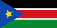
Flag of South SudanCountry Name:  
• South Sudan
Official Name:  
• Republic of South Sudan
Capital: Juba
(There are about 60 recognized national languages in South Sudan, but English is the country’s only “official working language”.)

South Sudan became independent and joined the UN in 2011, but for the last four years has been left out of the Olympics, apparently because it did not yet have a functioning national Olympic committee (NOC). But even though the country did not have an official team at the 2012 Olympics in London, one South Sudanese runner did attend those games as a specially-approved independent athlete.

The emergence of South Sudan’s NOC has come despite the country being locked in an ongoing civil war since 2013.

Other Newcomers
South Sudan is now one of 206 official Olympic nations, and the first new IOC member since disputed Kosovo was controversially admitted last December. Prior to South Sudan and Kosovo’s admissions, the newest Olympic members were Montenegro and Tuvalu, which both joined in 2007. Like South Sudan now, Montenegro was newly independent at that time.

You may also like: 
Which Countries Are (and Aren’t) in the Olympics?
Is South Sudan a member of FIFA?
All South Sudan articles on PolGeoNow

Graphic of the South Sudanese flag is in the public domain (source).

South Sudan War Map: Control at Time of January Ceasefire (Update #3) (Premium)

Map of rebel control in South Sudan's ongoing rebellion, showing situation at the time of the ceasefire of January 23, 2014

Download PDF
buy

(Subscribe via Paypal)

This is Part 1 of a double map report on territorial control in South Sudan’s ongoing rebellion, available exclusively to premium subscribers or for individual purchase. This map shows territorial control as of January 23, when the warring parties signed their ceasefire agreement (including major changes from previous update). Buy now (US$3.99).

To see the map of current control as of late February, go to Part 2.

Premium article includes:

  • Exclusive map of rebel control at the time the ceasefire was signed on January 23, 2014
  • Multiple changes to territorial control since previous update
  • Several new locations added to the map
  • Report chronicling changes to territorial control and describing the situation at the time of the ceasefire, including links to sources

Members click here to proceed to article and map

Not a member yet? Subscribe Now!

South Sudan War Map: Current Rebel Control (Update #4) (Premium)

Map of rebel control in South Sudan's ongoing rebellion, showing situation at the time of the ceasefire of January 23, 2014

Download PDF
buy

(Subscribe via Paypal)

This is Part 1 of a double map report on territorial control in South Sudan’s ongoing rebellion, available exclusively to premium subscribers or for individual purchase. This map shows current territorial control for late February 2014, including several changes since the time of the ceasefire. Buy now (US$3.99).

To see the map of control at the time of the ceasefire on January 23, see Part 1.

Premium article includes:

  • Exclusive map of current rebel control up to February 21, 2014
  • Multiple changes to territorial control since previous update
  • Several more new locations added to the map
  • Report chronicling changes to territorial control since the ceasefire, including links to sources

Members click here to proceed to article and map

Not a member yet? Subscribe Now!

South Sudan Rebellion: Map Update 2 (Premium Content)

Map of rebel control in South Sudan's ongoing rebellion, updated to Jan. 16, 2014

Download PDF
buy

(Subscribe via Paypal)

Both peace talks and fighting continue nearly two weeks after our last South Sudan update. In the meantime, there have been several changes to rebel control. The newly updated premium map and report reflect those events, as well as newly available information about other localities. Buy now (US$2.99).

Premium article includes:

  • Exclusive updated map of rebel control in South Sudan’s ongoing uprising (current as of January 16, 2014)
  • A number of new localities have been added to the map since last time
  • Report chronicling changes to territorial control since the previous map, with links to sources

Members click here to proceed to article and map

Not a member yet? Subscribe Now!

South Sudan: Rebel Control Map Update (Premium Content)

There are newer versions of this map available. To see the full list of updates, view all South Sudan articles

Map of rebel control in South Sudan's 2013-2014 political crisis, updated to Jan. 3, 2014

Download PDF
buy

(Subscribe via Paypal)

Since our first map report on rebel control in South Sudan’s political crisis, the situation has continued to develop quickly, with several cities and towns changing hands. PolGeoNow now presents an updated map and report exclusively available as premium content for purchase and to our subscribers. Buy now for only US$2.99!

Premium article includes:

  • Exclusive updated map of rebel control in South Sudan’s ongoing uprising 
  • Report chronicling changes since the previous map, with links to sources

Members click here to proceed to article and map

Not a member yet? Subscribe Now!

South Sudan Crisis: Rebel Control Map (Premium Content)

There are newer versions of this map available. To see the full list of updates, view all South Sudan articles

Report and map of rebel control in South Sudan's December 2013 political crisis; includes indications of control by state and city, including Juba, Bor, Bentiu, Malakal, and more

Download PDF
buy

After a sudden outbreak of political violence last week, the military of South Sudan has fragmented into two competing factions, with rebellious defectors capturing a large swath of the world’s newest country. PolGeoNow now presents the first map of rebel control in South Sudan’s ongoing crisis, an exclusive for premium subscribers and purchasers.

Premium article includes:

  • Exclusive, up-to-date map of rebel control by state and city in South Sudan’s ongoing uprising
  • Outline of the course of events so far, including the captures of three state capitals by rebel forces
  • Brief description of the causes and humanitarian consequences of the current conflict

Members click here to proceed to article and map

Not a member yet? Subscribe Now!

Map: Palestine Recognized by Two More Countries (134/193)

(Keep up with changes to Palestine’s situation: view all Palestine updates.)

Map of countries that recognize the State of Palestine as an independent country, updated for November 2013 with recent additions Haiti and South Sudan highlighted
Countries recognizing the State of Palestine in green, with most recent additions highlighted. Palestine in magenta (circled). Click to enlarge. Map by Evan Centanni, modified from public domain graphic (source).

By Evan Centanni

List Grows By Two
After being recognized as an Observer State by the U.N. last year to the protest of Israel, the U.S., and other Western countries, the State of Palestine is slowly continuing to receive diplomatic recognition from individual U.N. members. Last May we reported that 132 U.N. member states had officially recognized Palestine, and now the list has grown to 134 (69% of the world body’s total membership). Palestine is also recognized by the proclaimed government of disputed Western Sahara, which is not a member of the U.N.

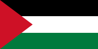
Flag of Palestine Country Name:  
• Palestine (English)
Filasṭīn (Arabic)
Official Name:  
• State of Palestine (English)
• Dawlat Filasṭin (Arabic)
Capital: 
• Jerusalem (claimed)
Ramallah (administrative)

New Recognition
The most recent country to recognize Palestine as independent is the Caribbean nation of Haiti, which did so near the end of this past September. An official ceremony was held for Haiti’s recognition at U.N. headquarters in New York, in which both Haiti and Caribbean neighbor Grenada signed agreements to establish diplomatic relations with the State of Palestine. However, Grenada has already been on the list for some time, offering its recognition a full two years ago according to the official website of Palestine’s U.N. delegation.

One More Country: Mystery Solved
As discussed in our previous Palestine recognition article, since last year the number of recognitions claimed by Palestine’s U.N. mission has been higher by one than the total number actually documented by observers. However, the confusion has now been cleared up by the publication of an official list on the delegation’s website.

This list includes one more country than previous third-party lists, recording newly independent country South Sudan as having offered its recognition on July 14, 2011, on the same day that it joined the U.N. In retrospect, this should come as no surprise, since South Sudan firmly supported Palestine’s 2011 bid for U.N. membership, and apparently did actually announce that it would grant diplomatic recognition (though that statement occurred later than the date now claimed by Palestine).

Related Articles:
Palestine Recognized as a Country by the U.N.
Is Palestine Really a Country?
Map of Countries Recognizing Kosovo

Map: Sudan & South Sudan’s Disputed Territories

Countries: South Sudan, Sudan
Official Names: Republic of South Sudan, Republic of Sudan
Summary: After South Sudan declared independence from Sudan last year, much of the border between the neighbors is still hotly disputed, with recent violent clashes around the Heglig oil field and other areas. Read on for a full list of Sudan and South Sudan’s eight major border flashpoints.

Map of the border between Sudan and South Sudan, marking selected territorial disputes and border clashes in 2012. Includes inset map of April fighting in region of Heglig oil field.
Border map of Sudan and South Sudan, showing disputed areas and fighting since the beginning of 2012. Aerial bombings and attacks by rebel groups not shown. My own work, using blank Sudan and South Sudan maps by NordNordWest / Wikipedia. License: CC BY-SA.


About the Sudan-South Sudan Border Conflict
Nearly one year after South Sudan separated from Sudan, the precise location of the border between the two countries has still not been agreed upon and demarcated (marked on the ground). An approximate border line has been drawn on the map following the route of an old internal boundary between the northern and southern regions of colonial Sudan – known as the “1956 border”, for the last date it was in effect before Sudanese independence. But its implementation is so messy that the two sides can’t even agree on how much is disputed, with Sudan claiming that 80% of the border has already been effectively agreed upon, while South Sudan says it’s only 40%. Last month, tensions boiled over into a small border war centered on Heglig, a northern-administered oil town claimed by South Sudan. Fighting spread briefly to other border areas, and many locations in the south were bombed by Sudanese planes.

Photographs: Pete Muller on the Sudan-South Sudan front lines

The following article profiles eight hotly contested or widely acknowledged disputed areas along the border between Sudan and South Sudan. (Note on spellings: Many of these place names come from Arabic or other local languages, and do not have agreed-upon English spellings. Alternate spellings are indicated in parentheses).

Heglig (Panthou)
(Also spelled Higlig or Hijlij)
The small, remote oil town of Heglig, known as Panthou to South Sudan, is apparently located on northern Sudan’s side of the 1956 border. However, older maps don’t label the town at all, and until 2003 it was administered as part of Unity State in the Southern Sudan region. Then, just after the Sudan government and the future independent South had agreed not to share oil from north of the border, the government abruptly informed the southerners that Heglig in fact belonged to the north’s Southern Kordofan state.

Further Reading: Note on Panthou/Heglig (PDF) – History and legal status
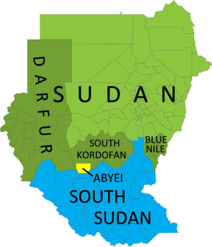
Map of current administrative areas of the former Sudan, distinguishing South Sudan, Sudan (plus areas with active rebellions), and the disputed Abyei area, which is jointly administered and policed by U.N. peacekeepers.
The former Sudan’s current administrative areas. Blue: South Sudan. Green: Sudan (darker green: states with active rebellions). Yellow: joint administration and U.N. peacekeeping force. Modified from this map by Wikimedia user Lokal_Profil (CC BY-SA 2.5).

Minds in the south weren’t changed so easily, and after two weeks of border clashes starting in late March of this year, South Sudan invaded Heglig. The southern government claimed they were only retaliating against earlier attacks by the north, but Sudan and the U.N. denounced it as an act of aggression. The South Sudanese army occupied Heglig from April 10-20, and advanced nearly as far as Kharasana (also Kersana, Karasana, Karasanah) before turning back – whether out of defeat or in order to stem international criticism is not clear. The front line has since moved back to Teshwin (also Tachiuen, Tishwin, Tashwin), an uninhabited spot on the 1956 border. Sudanese air strikes during the confrontation occurred deep within South Sudanese territory (PDF), including in Unity State’s capital of Bentiu, as well as Panakuac (also Pan Akuach, Pana Kuach), a military position on the road to Teshwin.

Video: Journalists witness Sudanese air raid

Abyei Area
Perhaps the most well known of the disputed regions along the border of the two Sudans, this region was singled out for special treatment in the 2005 agreement which led to Southern independence. Centered around the town of Abyei, the territory was to have its own referendum vote on whether to join South Sudan or remain part of the north. However, due to disagreements last year over who could to vote, the referendum failed to happen and the northern Sudanese Armed Forces (SAF) occupied the territory. Abyei is officially co-administered by the north’s South Kordofan state and the south’s Northern Bahr el Ghazal state, with security handled by a U.N. peacekeeping contingent called UNISFA; however, the part of the area north of the Bahr el Arab (Kiir) River is still occupied by the Sudanese army (PDF). South Sudan until recently maintained a police force in the area south of the river, but pulled it out two weeks ago at the demand of the U.N. Security Council (the north has defied the same order). [Update: Sudan finally withdrew its troops from Abyei on May 29.]

Kafia Kingi area
(Also spelled Kafia Kinji, Kafiya Kinji)
This is the largest of the regions disputed between Sudan and South Sudan, with its own confused history. Sudan seems to have transferred the area from the south’s Western Bahr el Ghazal state to the north’s South Darfur state in 1960 – too late to make it part of the north under the 1956 borders. However, some documents suggest it may have already been transferred by the British in the 1930’s (before 1956, making the transfer still valid today). In addition to the town of Kafia Kingi itself, the area also includes the copper mining town of Hofrat en Nahas (also Hufrat an Nuhas, Hufrat al Nahas) and the border town of Kafan Dabi (also Kafindabei, Kafn Dubai, Kafan Dibi), which was recently “recaptured” by the north.

Further Reading: Contested Borderlands: The Kafia Kingi Enclave
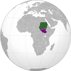
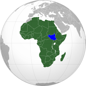
Map showing location of Sudan and South Sudan on a globe.
Location of Sudan (green) and South Sudan (purple) in Africa. Modified from this map (license: CC BY-SA).

Jau
(Also spelled Jao, Jaw)
Located right on the north-south border, this town on the frontier of Unity State and South Kordofan rose briefly to prominence after South Sudan claimed Sudan occupied their territory there last December, eventually leading to a victorious southern campaign to recapture the town in February. Rebel groups in the north simultaneously claimed credit for the victory, reinforcing Sudan’s accusation that the rebels are supported by the South Sudan government.

Bahr el Arab (Kiir) River
Called “River of the Arabs” by the north, and the Kiir River by the South, this is a locally important waterway that intersects the Abyei Area after running somewhat north of the 1956 border for a few hundred kilometers through South Darfur state. However, locals insist that the river is the real border, though it is unclear whether the South Sudan government itself actually claims the south bank. During last month’s outbreak of border warfare, fighting occurred in the riverside village of Kiir Adhem (also Kiir Adem, Kiir Adham), as well as a location known as Warguet, north of Aweil town in Northern Bahr el Ghazal state.

Kaka
This town on the White Nile river is located south of the 1956 boundary, within the state of Upper Nile. However, during the colonial era, the British allowed the town’s port to be administered by what is now Sudan’s Southern Kordofan state, and northern farmers over time established themselves in the Kaka area as well. South Sudan, however, argues that the town’s northerner administration did not make it technically a part of the north. Kaka has not been a flashpoint for fighting in recent months, but it remains on an agreed-upon list of disputed border areas. (Source: International Crisis Group report on Sudan north-south border)

Megenis Mountains
(Also Jebel Megenis, Magenis, Al-Muquinis Mountain)

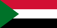
Flag of Sudan (source)

An outcropping of large hills rising several hundred meters over the surrounding plain (Google Maps), the Megenis Mountains are divided between Sudan’s White Nile and South Kordofan states and South Sudan’s Upper Nile state. Sudan claims the whole area as the traditional realm of one of its local peoples, but there are also rumors of oil lying beneath the ground, and this may be the real reason that Megenis remains on the list of territorial disputes. (Source: International Crisis Group report on Sudan north-south border)

Flag of South Sudan (source)

Jodha
(Also spelled Jordah, Goda)
This dispute arises from a history of multiple changes to the border between Renk County in the south’s Upper Nile state and Jebeleyn (or Jabalain) County in the north’s White Nile state. Although locals dispute the whole eastern half of the boundary between the two states, the governments of Sudan and South Sudan designated only a small area near the present-day border crossing of Jodha as a recognized territorial dispute. (Source: International Crisis Group report on Sudan north-south border.) During last month’s widespread border conflict, fighting broke out in the nearby town of Kuek, though some sources claimed South Sudan’s army faced an independent militia rather than the Sudanese Armed Forces.

Sources for map locations:
Situation Map: Sudan-South Sudan border areas (27 April, 2012) (PDF). U.N. Office for the Coordination of Humanitarian Affairs (OCHA).
Policy Briefing: Sudan: Defining the North-South Border. International Crisis Group.
Map of Southern Kordofan and Abyei. U.N. Cartographic Section.
South Darfur Planning Map: All Settlements. Humanitarian Information Center for Darfur.  
Sudan: Population Movement. International Federation of Red Cross and Red Crescent Societies.

South Sudan Gains Further Recognition

Country Name: South Sudan
Official Name: Republic of South Sudan
News Categories: Recognition, New Countries
Summary: Newly independent South Sudan has continued to be officially recognized by more of the world’s countries in the follow-up to its formation last July. The new state, whose sovereignty has already been acknowledged through admission to the U.N. and African Union, has also initiated a plan to move its capital from Juba to the more central location of Ramciel.

See Also: New Country: South Sudan

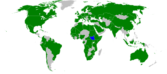
Countries which have officially stated their recognition of South Sudan’s sovereignty (green). South Sudan in blue. Modified from this Wikimedia map (public domain).

Full Story

South Sudan’s Coat of Arms (source)

The result of a peace agreement ending a long and bloody civil war, the official split between South Sudan and Sudan came on July 9th of this year. Since its declaration of independence had been pre-approved through treaty and diplomatic channels, the new Republic of South Sudan was immediately accepted onto the international stage, with dozens of countries rushing to grant it diplomatic recognition. It was welcomed into the United Nations within the week, and by the end of the month held a seat in the African Union. South Sudan has so far received formal recognition from 114 U.N. member states, as well as six non-members. However, since the country already holds a seat in the U.N. itself, and its independence was not opposed by any countries, new recognitions have since slowed due to their limited significance. Since the beginning of August, 10 more countries have recognized South Sudan, with the last newly reported recognition coming from Jamaica on October 6th. (Note: seven other states which recognized the country before August were were omitted from my last update due to lack of information.)

Wikipedia: Foreign Relations of South Sudan

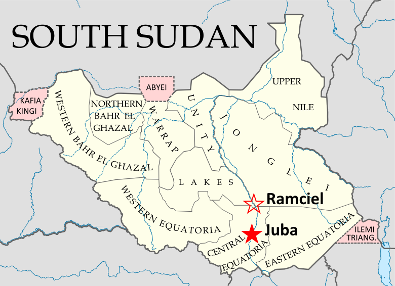
South Sudan’s states and disputed regions (pink), showing the current
capital (Juba) and the planned future capital (Ramciel). My own work,
Based on this map by NordNordWest/Wikipedia (license: CC-BY-SA).

South Sudan’s capital is currently located in the Juba, also its largest city, which is located on the White Nile river in the south of the country. However, there have long been proposals to move the capital to a more central location, and in September the government announced the official location of South Sudan’s next capital, a city which will be planned and built near the meeting point of the country’s three traditional provinces (now divided into a number of smaller states). The site is known as Ramciel, and is said to have been advocated by John Garang, southern Sudan’s leader from the civil war period, who died in a helicopter crash six years before the country achieved its official independence.

See Also: South Sudan Joins U.N.
Wikipedia: South Sudan

South Sudan Joins African Union

Country Name: South Sudan
Official Name: Republic of South Sudan
News Categories: Intergovernmental Organizations
Summary: New U.N. member South Sudan has been admitted into the African Union, the continent’s highest level intergovernmental organization. Formal recognition from individual countries is still continuing.

South Sudan (blue) in the A.U. (green). Modified from
this map by Wikimedia user Heraldry (CC BY-SA).

See Also: New Country: South Sudan

Full Story
Less than three weeks after declaring independence, the new Republic of South Sudan has been admitted into the African Union (A.U.). The A.U., which represents all of Africa’s countries except for Morocco, voted with a majority in favor of allowing South Sudan’s entrance into the organization. Membership will allow the new state to participate fully in the community of African nations, while the A.U. is soon to begin mediating talks over the remaining disputes between South Sudan and Sudan, the country from which it seceded this month. South Sudan is the 54th member of the African Union, and the first new member since Eritrea joined in 1993.

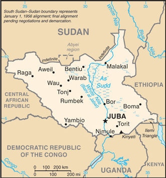
Map of South Sudan from the CIA
World Factbook
(public domain).

See Also: South Sudan Joins U.N.

In addition to A.U. and U.N. membership, South Sudan has continued to receive recognition from individual countries. Official statements of recognition for the new country have now been released by 97 U.N. members and six other sovereign states. Ninety-five U.N. member countries have not yet formally recognized South Sudan, but none have opposed it’s independence – an indication that they all intend to accept it as the world’s newest sovereign state.

Countries which have officially stated their recognition of South Sudan’s sovereignty (green). South Sudan in blue. Modified from this Wikimedia map (public domain).

Wikipedia: South Sudan, Foreign Relations of South Sudan, African Union