Somalia Control Map & Timeline – March 2018 (Subscription)

SUBSCRIBERS CLICK HERE TO PROCEED TO ARTICLE AND MAP

There are newer version of this map available. To see them, view all Somalia articles on PolGeoNow.

Map by onestopmap.com, Evan Centanni, and Djordje Djukic

Subscribe for full access to all conflict map reports!


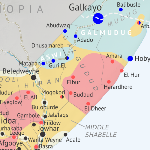
Who controls Somalia? Map (2018). With states, regions, and territorial control. Best Somalia control map online, thoroughly researched and detailed but concise. Shows territorial control by Federal Government of Somalia (FGS), Al Shabaab, so-called Islamic State (ISIS/ISIL), separatist Somaliland, and autonomous states Puntland, Galmudug, Khatumo, and the ASWJ Sufi militia. Updated to March 28, 2018. Colorblind accessible.
Since last summer, Al Qaeda’s Al Shabaab affiliate has lost some key towns in Somalia, but also had some victories – all this amid increasing US military involvement. Meanwhile, two pairs of rival governments farther north are moving towards unification.

See all this and more on the latest update to PolGeoNow’s concise, professional Somalia control map, which includes a timeline of changes since our previous Somalia map report of August 2017, with sources cited.

This map and report are premium content, available to paid subscribers of the PolGeoNow Conflict Mapping Service.

Want to see before you subscribe? Check out our most recent FREE SAMPLE Somalia map!

Exclusive map report includes:

  • Up-to-date illustration of current territorial control in Somalia, color-coded for the federal government coalition (including AMISOM peacekeepers), autonomous unionist forces, separatist Somaliland, Al Qaeda affiliate Al Shabaab, and fighters aligned to the so-called “Islamic State” (ISIS/ISIL). Areas of lawlessness and unclear control also clearly marked. Colorblind accessible.
  • Boundaries and labels for Somalia’s official regions, plus control lines for the autonomous administrations of Somaliland, Puntland, Galmudug, ASWJ, and Khatumo.
  • Detailed indication of city-by-city control, including many relevant smaller towns and villages.
  • Locations of recent fighting and other important events, including Bariire, Basra, Sablale, Torotorow, Tukaraq, and more.
  • Detailed timeline of territorial control changes and key political developments since August 25, 2017, with sources indicated. 
  • Brief summary of the conflict situation, as well as major changes to the alignment of autonomous administrations, over the past seven months.

SUBSCRIBERS CLICK HERE TO PROCEED TO ARTICLE AND MAP

Not signed up yet? Click here to learn more about our professional subscription service!

Syrian Civil War Map & Timeline: Afrin Separated from Turkey – March 2018 (Subscription)

SUBSCRIBERS CLICK HERE TO PROCEED TO ARTICLE AND MAP

There are newer versions of this map available. To see them, view all Syria updates.

Research by Djordje Djukic. Map by onestopmap.com, Evan Centanni, and Djordje Djukic

Subscribe for full access to all conflict map reports!


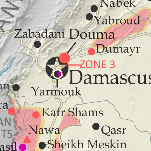
Map of Syrian Civil War (Syria control map): Fighting and territorial control in Syria in March 2018 (Free Syrian Army rebels, Kurdish YPG, Syrian Democratic Forces (SDF), Hayat Tahrir al-Sham (HTS / Al-Nusra Front), Islamic State (ISIS/ISIL), and others). Includes Russia-Turkey-Iran agreed de-escalation zones and US deconfliction zone, plus recent locations of conflict and territorial control changes, such as Afrin, the Eastern Ghouta rebel zone, and more. Colorblind accessible.
Over the past month, fighting has raged in three major flashpoints in Syria, with the Turkish invasion of Afrin, Assad’s new ground war against rebels near Damascus, and heavy infighting between rebel groups in the north.

See all this and more on the latest update to PolGeoNow’s concise, professional Syrian Civil War control map, which includes a timeline of changes since our previous Syria map report in February, with sources cited.

This map and report are premium content, available to paid subscribers of the PolGeoNow Conflict Mapping Service.

Want to see before you subscribe? Check out our most recent FREE SAMPLE Syria map!

Exclusive map report includes:

  • Up-to-date illustration of current territorial control in Syria, color-coded for the Assad government, rebel groups, “Islamic State” (ISIS/ISIL) fighters, and Kurdish/SDF forces. Colorblind accessible.
  • Markers showing the approximate locations of Russian-Turkish-Iranian “de-escalation zones” and the one known US “deconfliction zone”.
  • Special symbols indicating towns dominated by rebels of the former Al Qaeda Nusra Front (now Hayat Tahrir al-Sham or HTS) and by the US-backed Syrian Democratic Forces (SDF).
  • Detailed indication of city-by-city control, including key towns and other locations important to current events.
  • Locations of recent fighting and other important events, including Kurdish Afrin, the Eastern Ghouta rebel zone near Damascus, and more.
  • Detailed timeline of important events and changes to territorial control since February 13, 2018, compiled by our Syria-Iraq expert, with links to sources. 
  • Brief summary of current situation, as well as major changes to the configuration of territorial boundaries and de facto enclaves and exclaves.

SUBSCRIBERS CLICK HERE TO PROCEED TO ARTICLE AND MAP

Not signed up yet? Click here to learn more about our professional subscription service!

Can I purchase just this map?
This map and report are not available for automated purchase to non-subscribers. If you need access or republication rights for only this map report, contact service@polgeonow.com for options.

Gambia Rejoins the Commonwealth (Map)

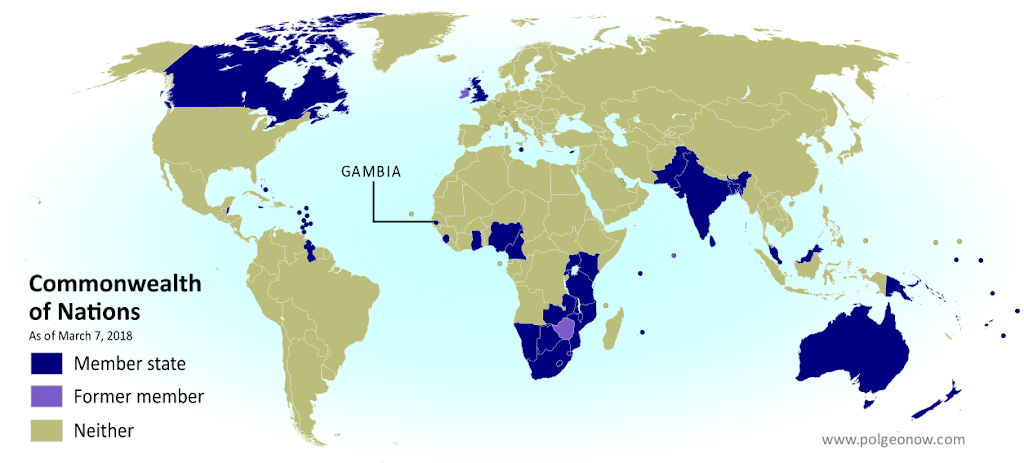
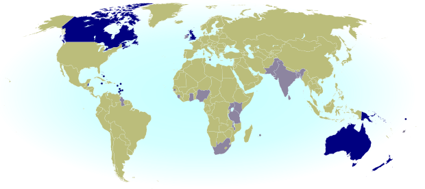
Map of the Gambia in the Commonwealth of Nations (British Commonwealth) as of 2018, color coded for former and current member countries (colorblind accessible).
Map by Evan Centanni, modified from public domain graphic. Visit our Commonwealth of Nations page to check for newer versions, or contact us for permission to use this map.

Commonwealth Readmits Gambia as Member

Last month the Republic of the Gambia was accepted back into the Commonwealth of Nations, a club of countries that were formerly part of the British Empire. The tiny West African country left the organization in 2013 under pressure from other members to improve its democracy and human rights record.

Flag of the Gambia Country Name:  
• The Gambia
Official Name:  
• Republic of the Gambia
Capital: Banjul

See Also: Gambia Withdraws from the Commonwealth (2014 article)

But since eccentric leader Yahyeh Jammeh was forced to step down last year after losing an election, new Gambian president Adama Barrow has made a point of reversing his predecessor’s more controversial policies. This has included undoing the country’s 2015 name change, canceling its withdrawal from the International Criminal Court, and now rejoining the Commonwealth.

Unanimous Decision

The Gambia’s readmission into the Commonwealth took effect on February 8, 2018, after its application was approved unanimously by the leaders of the other member countries. The move to re-apply had likewise been approved unanimously by the country’s own National Assembly.

Sometimes called the “British Commonwealth”, the Commonwealth of Nations is mainly a forum for cooperation between countries that were once parts of the British Empire (though it has also admitted other countries in the past). But any association it has with British colonialism is mostly symbolic –  Queen Elizabeth II is the formal “Head of the Commonwealth”, but within the organization itself, all members are equal and decisions are made by consensus.

Learn More: What is the Commonwealth of Nations, and what does it do?

Why Did Gambia Rejoin the Commonwealth?

In contrast to the country’s unceremonious departure in 2013, the Gambia’s reasons for rejoining the Commonwealth are pretty clear.

In a press release, the Gambian government explained that it feels exclusion from the Commonwealth was a loss for the country, shutting it out from cooperation on things like health and education while denying it the opportunity to punch above its weight on the international stage. The statement specifically mentioned the need for the tiny coastal country to have a voice on climate change issues, and also on how richer countries try to help poorer countries.

In a separate interview, Gambia’s foreign minister mentioned that membership will also help Gambia build its judicial system, allow it to participate in the Commonwealth Games (a major world sporting event), and make it easier for its citizens to live in other Commonwealth countries. When “Commonwealth citizenship” was stripped from the Gambia in 2015, Gambians living abroad lost the right to vote in the UK and some other Commonwealth countries, among many other privileges.

Flag of the Commonwealth of NationsOrganization Name:  
• Commonwealth of Nations
Founded: 1931 and 1949 in London, UK
Headquarters: London, UK
Website: thecommonwealth.org/

Commonwealth Members

The Commonwealth of Nations now has 53 members, making up about a quarter of all the world’s countries. The number today is the same as after the Gambia first left, since the Gambia’s readmission is offset by the Maldives quitting the group in 2016. Participation in the Commonwealth is completely voluntary, and any member country can leave or reapply at will.

With the Gambia back in, there are now just three ex-Commonwealth countries in the world: Ireland left when it broke ties with the UK in 1949, and Zimbabwe exited in 2003 after a year of suspension over democracy issues.

It’s a common misconception that all the Commonwealth countries recognize the queen of England as their monarch. The countries that do share Queen Elizabeth II are called the “Commonwealth Realms“, but most Commonwealth countries don’t have a king or queen at all, and a few have their own separate monarchs. Elizabeth II’s current position as Head of the Commonwealth is separate from her role as the queen of the Realms, gives her no authority over member countries, and won’t be automatically inherited by her successor.

See Also: Queen Elizabeth’s 16 Countries: The Commonwealth Realms

Interested in the Commonwealth? You can always find the latest map and related articles on our Commonwealth of Nations page.


Low-resolution graphic of the Commonwealth flag is displayed under fair use principles (source). Flag of the Gambia is in the public domain (source).

What Are the Commonwealth Countries? Map of the Commonwealth of Nations

This map and explainer will be updated whenever there’s a change in Commonwealth membership, including suspensions and reinstatements. You can find articles on each change by scrolling to the bottom of this page, or by viewing all Commonwealth articles on PolGeoNow.
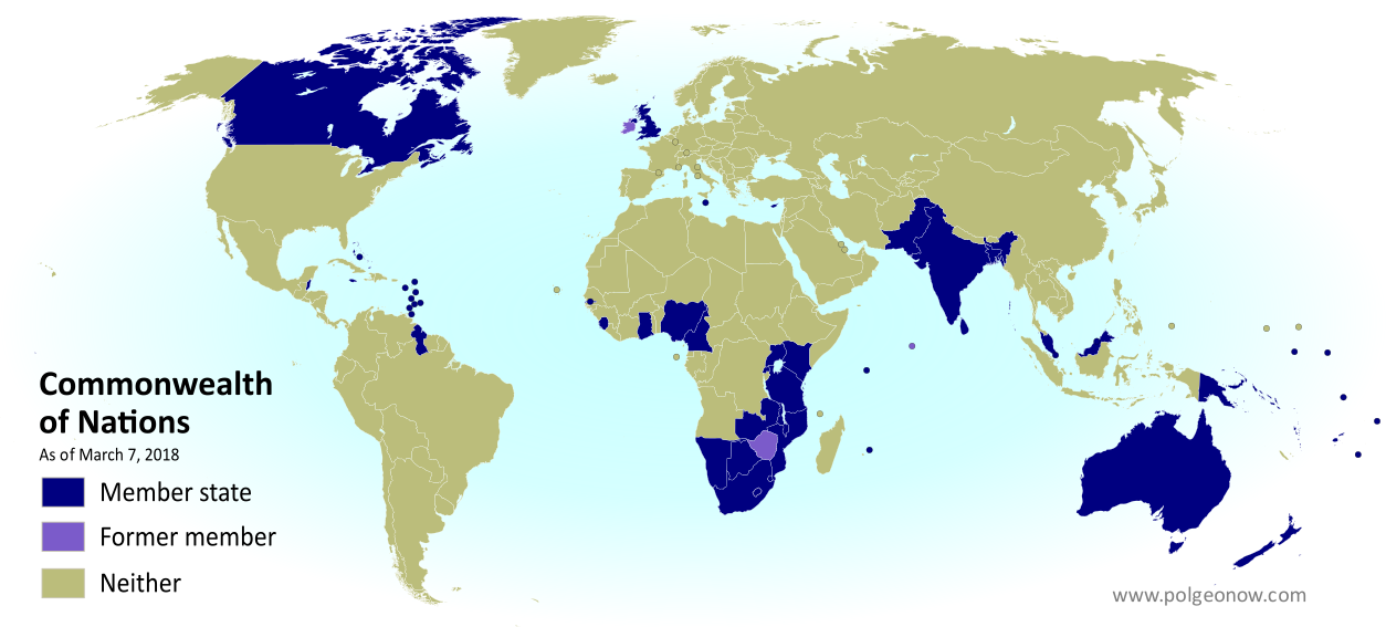
The Commonwealth: Who belongs to it? Map of current and former member countries of the Commonwealth of Nations (British Commonwealth) as of March 2018 (colorblind accessible).
Map by Evan Centanni, modified from public domain graphic. Contact us for permission to use this map.

(Subscribers click here to view this article in the members area.)

What is the Commonwealth of Nations?

The Commonwealth of Nations – formerly the “British Commonwealth”, but now usually just called “the Commonwealth” – is a loose association of countries that grew out of the British Empire as its colonies transitioned into independent countries during the 20th Century. It more or less took its modern form in 1949, but its history goes back at least to 1926, when the most Westernized colonies of the British Empire were transitioning towards independence. It’s mostly a casual forum for cooperation between countries that used to be British colonies or dependencies (though some other countries have joined), and it has a charter promoting values like world peace, democracy, and human rights.
Flag of the Commonwealth of NationsOrganization Name:  
• Commonwealth of Nations
Founded: 1931 and 1949 in London, UK
Headquarters: London, UK
Website: thecommonwealth.org/

What does the Commonwealth Do?

Unlike the European Union, World Trade Organization, and many other prominent intergovernmental organizations, the Commonwealth isn’t built around any kind of trade agreement or economic treaty, though its member countries do tend to favor trading with each other. Instead, it’s mostly a framework for promoting democracy and human rights, raising money for economic development, and nurturing cultural ties between its member countries.

Commonwealth-wide organizations coordinate international cooperation on education, professional development, and most famously sports: The Olympics-style Commonwealth Games are held every four years as a symbol of friendship between countries with historical ties to each other.

How Many Countries are in the Commonwealth?

Today there are 53 Commonwealth nations – about a quarter of all the world’s countries – all of them independent countries that also have membership in the UN. Participation in the Commonwealth is completely voluntary, and a member country can leave or reapply whenever it wants.

In the history of the Commonwealth, six countries have quit the organization, and one country, Fiji, was pushed out in 1987 over a military coup. Ireland, a member from the organization’s beginning, became the first to leave when it broke ties with the British monarchy and became a republic in 1949. At the time, the Commonwealth was still only for semi-independent “Dominions” sharing the British Queen or King.

South Africa then left in 1961 over the apartheid controversy, and Pakistan quit in 1972 when the Commonwealth recognized Bangladesh’s secession. Three more countries – Zimbabwe, the Gambia, and the Maldives – have withdrawn over the past fifteen years after being accused of disrespecting democracy or human rights. Fiji, South Africa, Pakistan, and the Gambia have all since rejoined.

Another four former members countries are gone from the Commonwealth simply because they don’t exist anymore: In 1949, semi-independent Newfoundland merged with Canada; in 1963, Malaya merged with Singapore, Sarawak, and North Borneo to form Malaysia (with Singapore splitting off again two years later and joining the Commonwealth separately); and in 1964 Tanganyika and Zanzibar merged to form Tanzania. All the new countries that resulted from those mergers are now Commonwealth members themselves.

See Also: BBC timeline of Commonwealth history (1926-2014)

Which Commonwealth countries is the queen head of? Map of current and former Commonwealth Realms - independent countries that share the British monarchy.
Map of the Commonwealth Realms: independent countries that share Queen Elizabeth II as their head of state

The Commonwealth and the Queen

It’s a common misconception that all Commonwealth countries recognize the British Queen as their leader. Although Queen Elizabeth II is the official “Head of the Commonwealth” for now, most member countries don’t recognize any king or queen in their own constitutions, and a few have their own separate monarchs.

Still, 16 of the 53 Commonwealth countries do recognize the queen as their official leader, despite having fully independent governments. These countries are a subset of the Commonwealth known as the “Commonwealth Realms“.

Learn More: Which Commonwealth countries is the queen head of?

Commonwealth News on Political Geography Now

Political Geography Now brings you ongoing coverage of all changes to Commonwealth membership, including withdrawals, admissions, suspensions, and reinstatements. News articles about these changes, as well as other features related to the Commonwealth, are listed here:
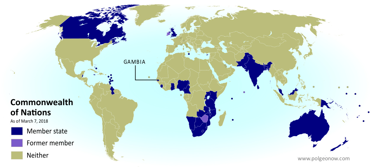
Map of the Gambia in the Commonwealth of Nations (British Commonwealth) as of 2018, color coded for former and current member countries (colorblind accessible).Gambia Rejoins the Commonwealth
Under a new government, Gambia rejoined the Commonwealth in February 2018, four years after leaving.

Full map and article
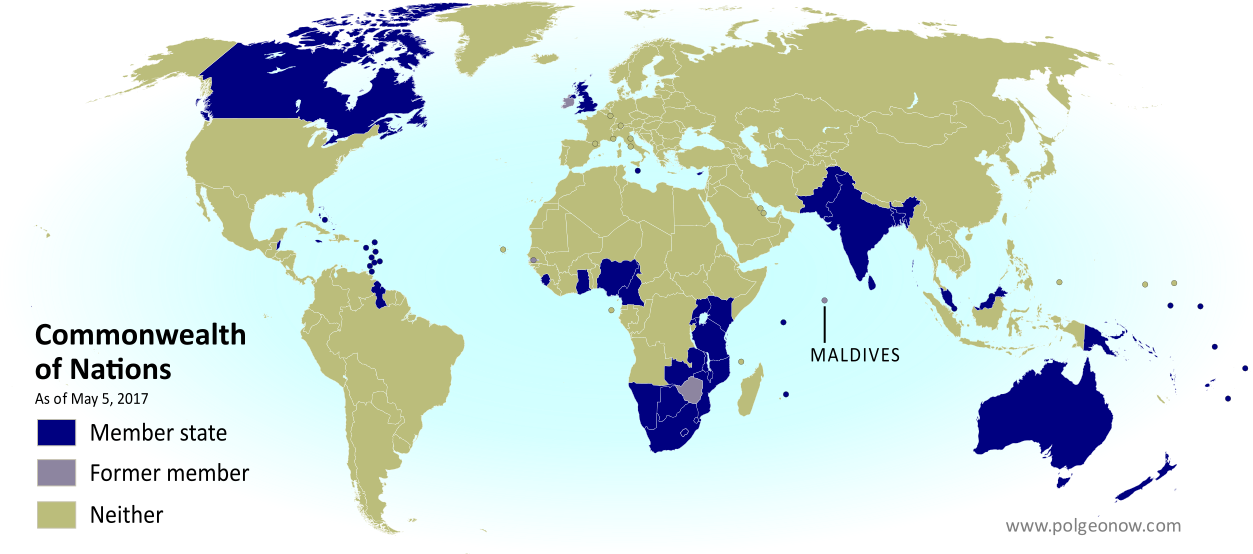
Map of current and former member countries of the Commonwealth of Nations (British Commonwealth) as of May 2017, showing where the Maldives are on the world map after the country left the organization (colorblind accessible).Maldives Withdraws from the Commonwealth
The small Indian Ocean country of the Maldives chose to exit the Commonwealth in October 2016 after being threatened with suspension.

Full map and article
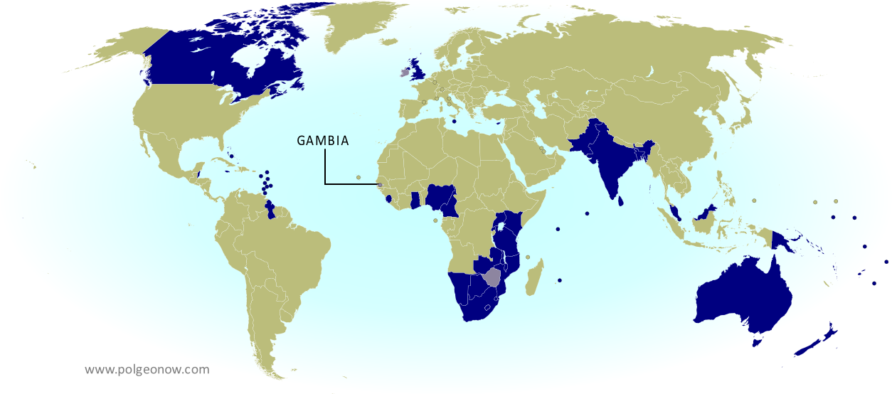
Map of current and former member countries of the Commonwealth of Nations (British Commonwealth) as of 2014, marking the Gambia, which withdrew from the organization in 2013 (colorblind accessible).Gambia Withdraws from the Commonwealth
In October 2013, the eccentric ruler of the Gambia, a tiny country in West Africa, withdrew unexpectedly from the Commonwealth, complaining of “neo-colonialism”.

Full map and article
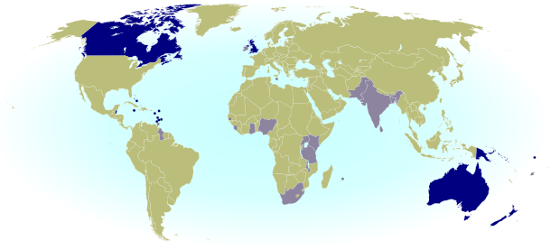
Which Commonwealth countries is the queen head of? Map of current and former Commonwealth Realms - independent countries that share the British monarchy.Queen Elizabeth’s 16 Countries: The Commonwealth Realms
How can 16 of the Commonwealth countries all share the same queen, but still be independent? Which countries are they? Find all the answers in this popular PolGeoNow feature!

Full map and article


Graphic of the Commonwealth flag is displayed under fair use principles (source).