Central African Republic: Towns Retaken by Government-allied Forces (September 2013)

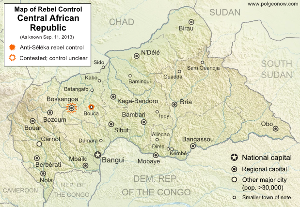
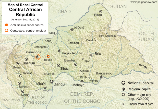
Map of control in the Central African Republic's anti-Seleka counter-rebellion, including towns of Bouca and Bossangoa
Counter-rebels briefly captured at least one Central African Republic town in September (click for full map and article). Map by Evan Centanni from this map by Wikimedia user Keitsist. License: CC BY-SA

Territory Nominally Reunited
Two weeks ago, Political Geography Now reported on rebel control in the Central African Republic’s new counter-rebellion. Since then, the towns of Bouca and Bossangoa have reportedly both been recaptured by forces belonging to Séléka, the former rebel coalition whose leader is now the president of the Central African Republic.

However, as outrage grows over vicious violence against civilians which has continued since Séléka’s campaign to take over the Central African Republic earlier this year, the new President Michel Djotodia has little actual control over the country.

One another analyst says that “law and order stops outside the presidential palace” in Bangui, and the AFP reported earlier this month that “A large number of [Séléka] fighters answer only to their direct leaders, who have carved out personal fiefdoms in the wake of the rebellion”. This raises serious questions regarding President Djotodia’s claims that he is now dissolving and outlawing the Séléka organization.

More information: Rebel Control Map: Central African Republic’s Counter-Rebellion

To see Séléka’s rise to power illustrated in rebel-control maps, view all Central African Republic articles.

Bangsamoro Republik? Philippine Separatists Seize Territory (map)

Zamboanga City in the southwestern Philippines came under rebel attack last week, with insurgents seizing and occupying several neighborhoods. Because the fighters are from a rebel group that declared independence in August, their newfound territorial control might technically be considered the birth of a new breakaway state. Details and discussion below!

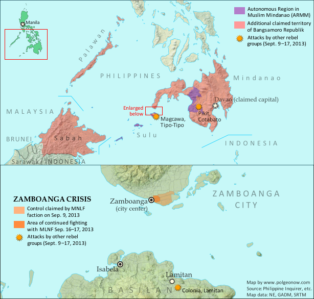
Map of territory in the Philippines and Malaysia claimed by the Bangsamoro Republik, plus territorial control by the Moro National Liberation Front (MNFL) as part of the Zamboanga crisis.
Claims and territorial control of the MNLF rebels/Bangsamoro Republik. Map by Evan Centanni.

Moro Rebellion
The southern Philippines is home to a long-running rebellion in the name of self-rule for the Moro people. The Moros are distinguished from other ethnic groups in the Philippines by their history as subjects of the Muslim kingdoms called sultanates, which ruled the southwestern islands until the late 1800s. Moro people today are typically Muslims, whereas the majority of Filipinos are Catholic.

Resistance to outside control of the southern Philippines goes back at least to the Moro Rebellion against U.S. occupation 100 years ago; but the modern insurgency began with Nur Misuari’s founding of the Moro National Liberation Front (MNLF) in 1969. After 20 years of fighting between the MNLF and the Philippine government, an agreement created the Autonomous Region of Muslim Mindanao (ARMM), and in 1996 the MNLF declared an end to the war. After that, a Moro-led insurgency continued, but at the hands of another group, the Moro Islamic Liberation Front (MILF).

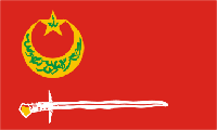
Flag of the Bangsamoro Republik and the Moro National Liberation Front (MNLF) rebels in the PhilippinesCountry Name:  
• Bangsamoro Republik
Official Name:  
• United Federated States of Bangsamoro Republik (UFSBR)
Capital: Davao City (claimed)

Bangsamoro Republik
Today the ARMM’s self-rule provisions still haven’t been fully implemented, and with the Philippine government in the process of arranging a separate peace agreement with the MILF, some MNLF members have become disillusioned with their own deal. Last month, a faction of the MNLF joined the organization’s original founder, Nur Misuari, in declaring an independent country called the Bangsamoro Republik.

“Bangsamoro” is a traditional name for the homeland of the Moro people, and the declaration of independence claimed the Mindanao, Sulu, and Palawan regions of the Philippines for the new country. Though the founders of the republic are Muslims, they’re not Islamists: the MNLF says Bangsamoro will be inclusive of all ethnic groups and religions in the region. But for all its talk of independence in August, the Bangsamoro Republik didn’t actually control any territory at all – until this week.

Battle for Zamboanga
Two weekends ago, unarmed MNLF members began arriving in the city of Zamboanga, outside the boundaries of the ARMM, for a planned demonstration against the Philippine government. But when armed fighters started landing in boats that Sunday night and Monday morning, allegedly with plans to raise the Bangsamoro flag in the city’s main square, they were engaged by the national military. The MNLF fighters, said to be from Misuari’s pro-independence faction, soon claimed to have seized seven neighborhoods of Zamboanga City from the government (though official statements put the number at only six).

The situation has since escalated into a drawn-out standoff, with the army reluctant to charge into the rebel-controlled areas for fear of harming civilians, who the rebels have taken hostage as human shields. But the Philippine military has gained some ground. By Sunday, the government claimed the rebels only remained in two neighborhoods, though fighting reportedly continued in at least three. On Monday the government announced that it had taken back 70% of the area the rebels controlled a week before. However, by Tuesday evening the story had changed, and officials were again acknowledging rebel control in pockets of five or six neighborhoods.

A Real Breakaway State?
Rebel control of these few neighborhoods might technically be considered the birth of the Bangsamoro Republik as a real breakaway state. The republic still isn’t recognized by any other countries, but since it now has both a declaration of independence and a territory under the control of its forces, it may qualify as a de facto sovereign state like Somaliland or Transnistria. In fact, Wikipedia editors have already added it to the encyclopedia’s list of sovereign states.

However, it seems unlikely the standoff will develop into any kind of long-term occupation under a rebel administration. What’s more, it’s actually not completely clear who the fighters are representing. As expected, leaders of MNLF factions other than Misuari’s, including the government of the ARMM, have condemned or distanced themselves from the attacks. But more surprising are claims by the mayor of Zamboanga City that Misuari himself, who led the declaration of independence, has denied sanctioning the attacks. Whether this is correct remains to be seen; other Philippine government and military figures continue to believe that Misuari is responsible. The leader of the rebel forces on the ground is Habier Malik, an MNLF commander with close ties to Misuari.

Claims to Malaysian Borneo

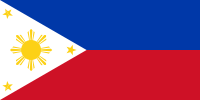
Flag of the PhilippinesCountry Name:  
• Philippines (English)
• Pilipinas (Filipino)
Official Name:  
• Republic of the Philippines (English)
• Republika ng Pilipinas (Filipino)
Capital: Manila

The MNLF’s website claims that the Bangsamoro breakaway state is to include not only regions of the Philippines, but also the Malaysian state of Sabah. Sabah was historically part of the Sultanate of Sulu, a Muslim kingdom based in the southwestern Philippines, and earlier this year was the scene of clashes with rebel forces claiming to represent the sultanate’s surviving royal family. Jamalul Kiram III, the leading contender for the throne of Sulu, argues that Sabah was only rented to Malaysia, and should still belong to his kingdom (and by extension to the Philippines).

Kiram’s position on the Bangsamoro Republik is that the breakaway state has no claim to Sabah, but that its declaration of independence is otherwise valid – however, he won’t support the creation of the state by military force. Meanwhile, Nur Misuari’s legal counsel has been quoted saying that even the neighboring Malaysian state of Sarawak is claimed by the Bangsamoro Republik. But this claim has not been confirmed by Misuari himself, and appears not to be supported by information on the MNLF’s website.

Basilan and Cotabato Attacks
Last week two additional battles began in Basilan province, an island located just across a narrow strait from Zamboanga. The attackers are also Moro fighters, but their actions are apparently not connected to the siege of Zamboanga – they might just be taking advantage of the distraction. Though some of the militants attacking Basilan’s Lamitan City are said to be members of the MNLF, most of them appear to be from Abu Sayyaf, a more extreme group known for its attacks on civilians and ties to international terrorist organization Al Qaeda.

Also last week, a separate attack was carried out in Cotabato province by the Bangsamoro Islamic Freedom Fighters (BIFF), another rebel group with no direct relation to the declared Bangsamoro Republik. Unlike the Bansamoro Republik’s MNLF rebels, both Abu Sayyaf and BIFF want to implement Islamic law  in the Moro homeland.

Followup article: Philippine Rebels Defeated

Related Articles
Is Palestine Really a Country?
New Country: Azawad Declares Independence from Mali
Rebel Control Map: Central African Republic’s Counter-Rebellion 

Graphic of the Bangsamoro Republik flag by Jaume Ollé/Wikimedia (CC BY-SA; source). Graphic of the flag of the Philippines is in the public domain (source).

Rebel Control Map: Central African Republic’s Counter-Rebellion (September 2013)

Map of 2013 counter-rebellion in the Central African Republic, showing current control by anti-Séléka (possibly pro-Bozizé) rebels as known on September 11, 2013.
Little sooner than Séléka rebel leader was sworn in as president, a new counter-rebellion has sprung up in the Central African Republic. Map by Evan Centanni from this map by Wikimedia user Keitsist. License: CC BY-SA

Previously: Séléka Coalition Takes Control of Central African Republic (Map of Rebel Advance)

Rebellion and Counter-Rebellion
Starting last December, a rebel coalition called Séléka swept across the Central African Republic from the north, capturing much of the country by January (see our first map of rebel control in the CAR). After a short-lived attempt at peace, Séléka renewed its campaign, capturing the capital and forcing President François Bozizé to flee the country. Rebel leader Michel Djotodia declared himself president, and Séléka has remained the major power in the country despite outbreaks of violence and general chaos.

Flag of the Central African RepublicCountry Name:  
• Central African Republic (English)
• Centrafrique (French)
• Bêafrîka (Sango)
Official Name:  
• Central African Republic (English)
• République centrafricaine (French)
• Ködörösêse tî Bêafrîka (Sango)
Capital: Bangui

Djotodia consolidated his power with an official presidential inauguration last month, but the conflict has proven to be far from settled. This Monday, heavy fighting broke out near Bossangoa, a city in the northwest, with anti-Séléka rebels reportedly taking over six unspecified towns in the area. Djotodia’s government said Bouca was one of the captured towns, while blaming the uprising on supporters of former president Bozizé.

The area is indeed Bozizé’s home region, though the rebels may not all be his supporters. A newspaper from Ghana reported that the rebels called themselves Anti-Balaka, which it translated as “Anti-Machete”. The same report also indicated that Bossangoa itself had fallen under rebel control, though other sources only state that fighting is ongoing in the surrounding villages as the city is being abandoned by fleeing civilians.

Stay tuned to Political Geography Now’s Central African Republic channel for updated maps of this evolving situation!

Related:
Syrian Civil War Control Map
Map of Nigeria’s War on Boko Haram
War in Somalia: Map of Al Shabaab Control

Graphic of the flag of the Central African Republic is in the public domain (source).

Lies Your World Map Told You: 5 Ways You’re Being Misled

Unfortunately, most world political maps aren’t telling you the whole story. The idea that Earth’s land is cleanly divvied up into nation-states – one country for each of the world’s peoples – is more an imaginative ideal than a reality. Read on to learn about five ways your map is lying to you about borders, territories, and even the roster of the world’s countries.
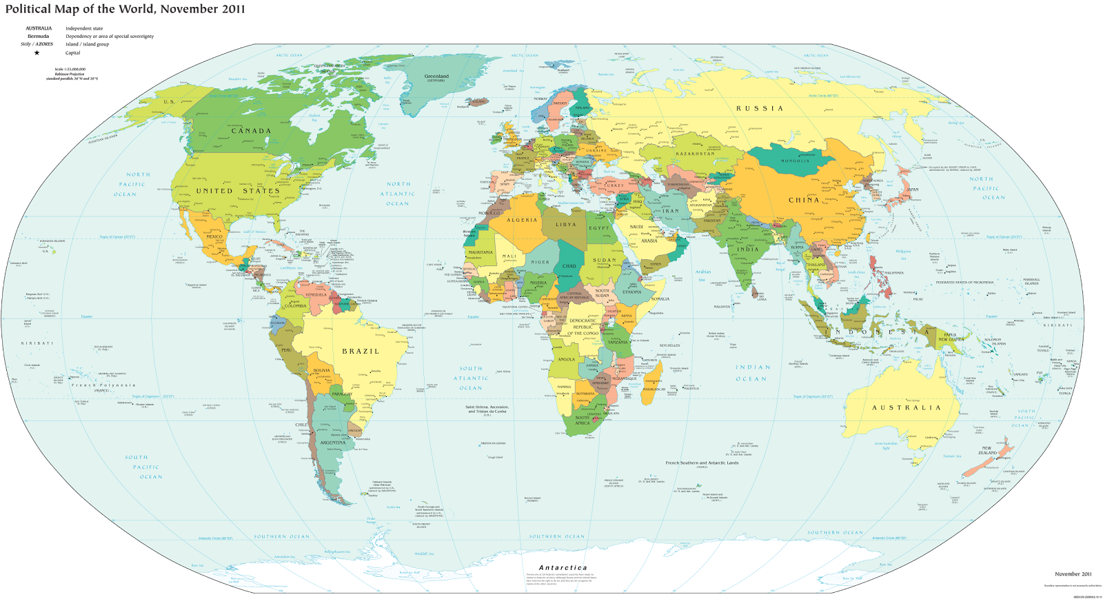
Map of the world's countries according to the U.S. Central Intelligence Agency
The lines and coloring on this map are hiding major truths about the world’s countries.
(Source: U.S. CIA; public domain)

1) Missing Countries
When choosing what counts as a country, most world maps go by either the official list from their own country or the member/observer roster from the United Nations. Just one problem: there are about ten countries which have declared and enforced their independence, but aren’t recognized by the U.N. or most of the world’s governments. These states may have close ties to a neighbor country, but most of them aren’t at all controlled by the country they’re supposed to be part of.

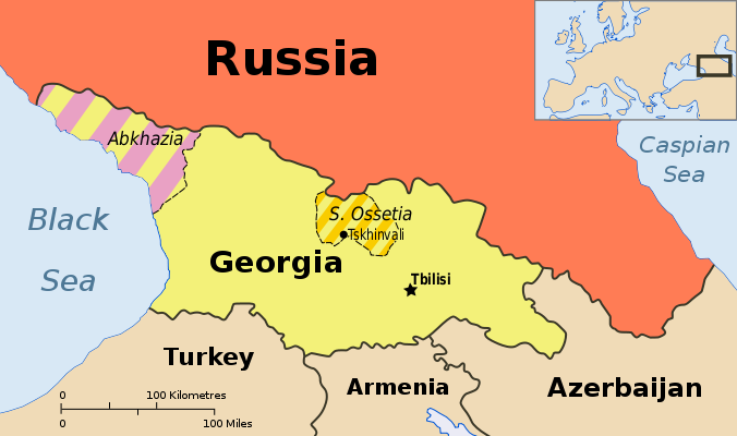
Map showing Abkhazia and South Ossetia, two breakaway states claimed by Georgia.
Abkhazia and South Ossetia operate as independent countries, but are claimed by Georgia and only recognized by a few countries. Map by Ssolbergj (CC BY-SA).

There are some high-profile special cases that warrant at least a note on many maps. Taiwan’s government formally claims to represent non-communist China, though it acts more like a separate country. Palestine, another disputed state, is now recognized as a U.N. observer country despite being forced to share control of its territory with Israel.

Western Sahara‘s status is considered unresolved by the U.N., and a small piece is effectively independent; meanwhile, Northern Cyprus is recognized only by its patron country, Turkey. The self-proclaimed Republic of Kosovo is now recognized by half of the U.N.’s members but not by the U.N. itself.

Other countries escape entirely from all but the most careful of political maps, being misleadingly merged into the countries that claim their territories: Abkhazia and South Ossetia into Georgia, Nagorno-Karabakh into Azerbaijan, and Transnistria into Moldova. These four breakaway states are sponsored by neighboring countries, but the most left out of all is Somaliland, which receives no major support or recognition from anyone, despite managing its affairs completely independently from Somalia.

Unrecognized Countries: More Articles and Maps

2) Incomplete Control
Drawing lines around a country on the map might imply that its government controls all the land within those lines. But that’s often not the case in reality. Even setting aside foreign military occupations like the recent U.S. interventions in Iraq and Afghanistan, many countries’ governments don’t control their whole territories. Aside from the cases of breakaway states as described earlier, this mainly occurs in war zones where rebel groups are actively vying for control of all or part of the country.

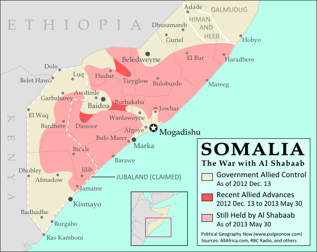
Map of government and Al Shabaab control in Somalia's ongoing civil war
Large parts of Somalia are controlled by Al Shabaab extremists. Click for map attribution info (CC BY-SA).

Somalia is probably the most infamous for this. Its U.N.-recognized government controls around half the country at best, and a few years ago controlled nothing but a part of the capital city! The rest is divided between the religious extremist Al Shabaab and various autonomous states which keep their own counsel on whether to cooperate with the government.

The territories of Mali, Nigeria, the Central African Republic, Libya, and Ivory Coast have all only recently been reunited (either under the former government or under the rebels), and Syria is the current model of a state falling apart through violence. Other countries with rebels firmly controlling parts of their territory are Yemen, the Democratic Republic of the Congo, and Myanmar/Burma.

Divided Countries: More Articles and Maps

3) Undefined Borders

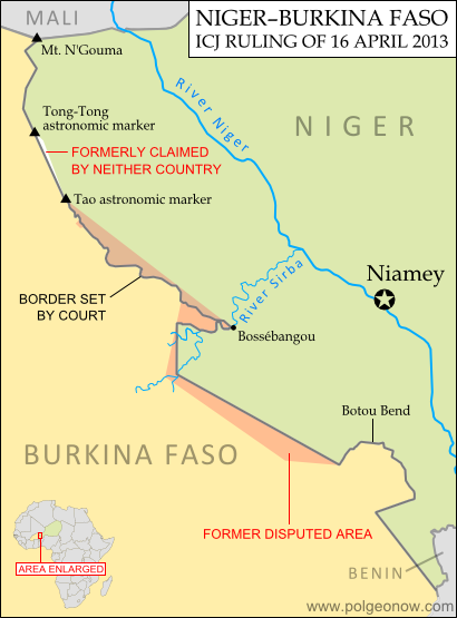
Map of the border dispute recently resolved between Niger and Burkina Faso
Niger and Burkina Faso recently resolved an unclear border situation. Map by Evan Centanni (click for details; CC BY-SA).

Another thing political maps imply is that borders at least have strictly defined locations in principle, even if they’re usually invisible on the ground. If they weren’t well-defined, they wouldn’t all be drawn with solid lines on the map, right? Wrong. Many countries have borders that have never been precisely defined by treaties, a process called “delimitation”.

Even fewer have been actually “demarcated”, or marked on the ground. In fact, undefined borders are such a big issue among the relatively young countries of Africa that the African Union operates an official border program to encourage the ongoing delimitation of national boundaries.

The fudge factor in national borders isn’t always big enough to make a difference to where they’re drawn on the world map – but their fuzziness can sometimes have major effects on international relations. An undefined border is a ripe environment for the birth of territorial disputes when neighboring countries have different ideas of where the border should run.

Sometimes these disputes are only low-level disagreements, such as the one recently resolved between Niger and Burkina Faso; but in other places like the border between Sudan and South Sudan, they can escalate into bloody conflicts.

Undefined Borders: More Articles and Maps

4) Disputed Territories
Your world map may label a few well-known territorial disputes, caused either by vague borders or conflicts over island groups. You might then reasonably conclude that disagreements over who owns a place, though they do happen, are relatively few and far between. Unfortunately, your conclusion would be incorrect. There are far more disputed territories in the world than you’ve probably ever imagined.

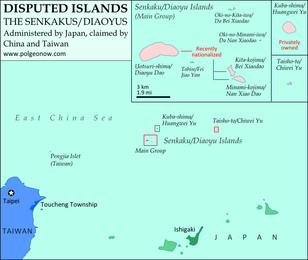
Map of the Senkaku/Diaoyu Islands, controlled by Japan but claimed by China and Taiwan
Map of the Senkaku/Diaoyu Islands, disputed between Japan, China, and Taiwan (map by Evan Centanni).

The most bizarre disputes range from high-profile cases, such as the five-way feud over the Spratly Islands, to quieter anomalies like Bir Tawil between Sudan and Egypt, both of whom claim it belongs to the other.

You may have heard of those, but did you know that (at least on paper) Mongolia is claimed by Taiwan? Or that more than half of Guyana is claimed by Venezuela? What about the several territories disputed between the U.S. and Canada? And those are just the land disputes – wait until you hear about the oceans!

Disputed Territories: More Articles and Maps

5) Territorial Seas
One thing completely left off of most maps is ownership of the sea. The occasional border lines you see across straits on your map are just showing who owns the islands on either side, not who owns the sea in between. The uninterrupted expanse of blue on most maps then might imply that the seas are the domain of no country. This is true for parts of the open ocean far from any coastline – but closer in, countries can and do exercise territorial rights over their neighboring seas. According to international best practices, a country is entitled to extend its territory up to 12 nautical miles (NM) out from its coastline, regulate economic activity out to 200 NM, and sometimes control seafloor oil and mineral exploration out to much further.
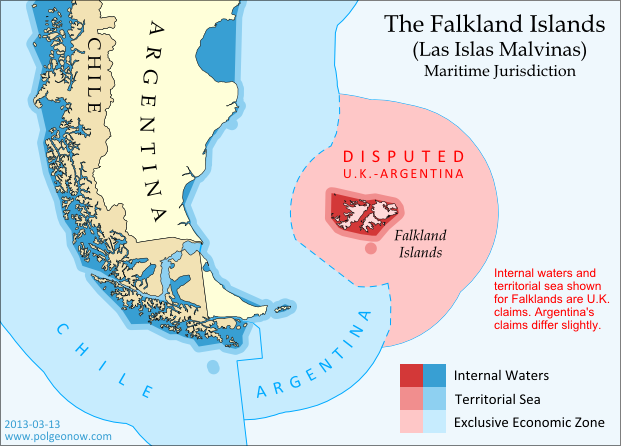
Map of territorial seas and exclusive economic zones (EEZ) around the Falkland Islands (Malvinas), controlled by the U.K. but claimed by Argentina
Both the land and the seas of the Falkland Islands are disputed between the U.K. and Argentina. Map by Evan Centanni (click for details; CC BY-SA).

But the divvying up of the world’s seas is still an ongoing process, and there are probably even more maritime disputes than land-based ones. Some countries, like Peru and Ecuador, refuse to recognize the 12 NM limit, claiming sovereign territory out to a full 200 NM. In even more cases, neighboring countries just can’t agree on where to draw the border between their respective territorial seas.

International law does provide guidance on how to divide it up, but for now many countries make claims far beyond what seems reasonable, apparently hoping they have something extra to give away in future negotiations. The most extreme claims, like China’s infamous “Nine-dotted Line” around most of the South China Sea, don’t seem to follow much legal logic at all.

Maritime Jurisdiction: More Articles and Maps

So next time you find yourself looking at a political map of the world, remember to be critical and take those borders with a grain of salt!

Other Articles You Might Like:
5 Countries You’ve Never Heard Of (by Their Native Names) 
How Many Countries Are There in the World?
Parade of Nations: Which Countries Are (and Aren’t) in the Olympics?