Taiwan Loses “Recognition” from El Salvador (Map)

You can always find the latest version of this map, and a list of all related articles, on our Which Countries Recognize Taiwan? page.
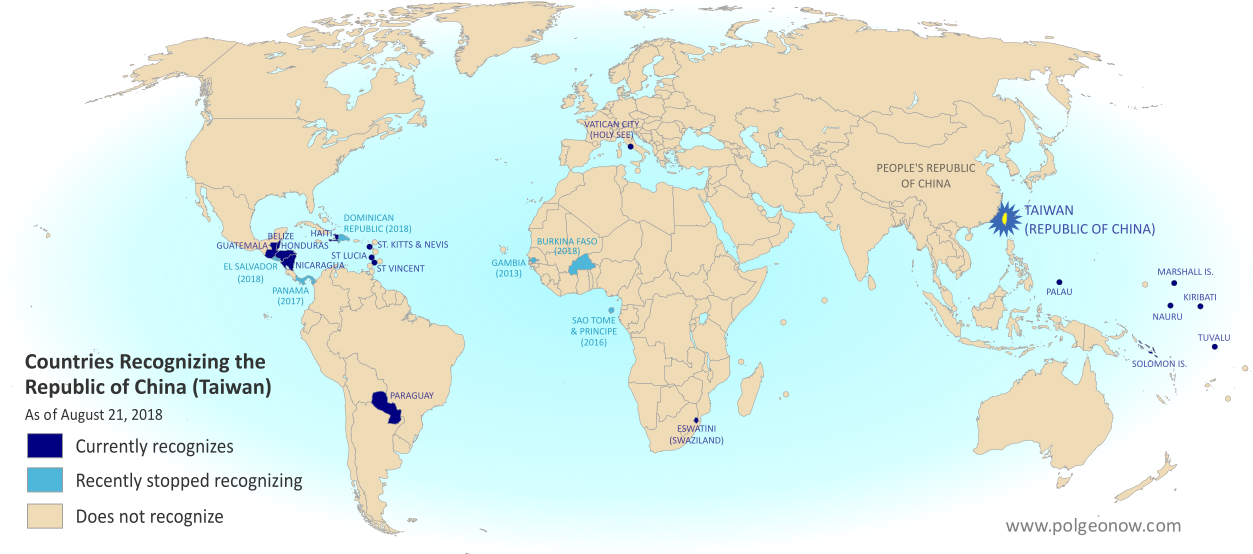
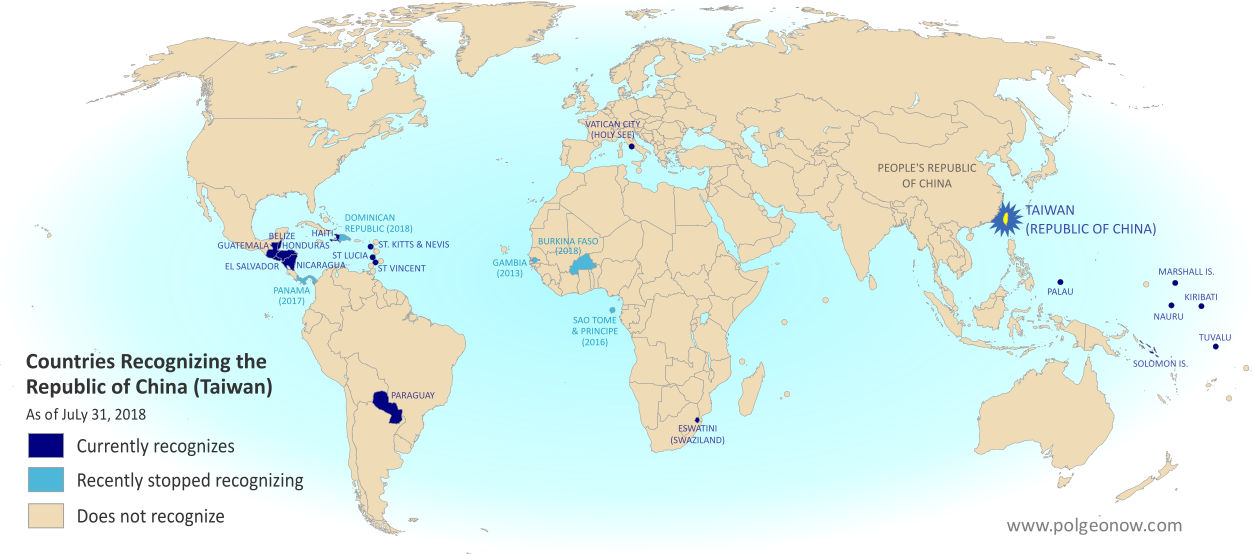
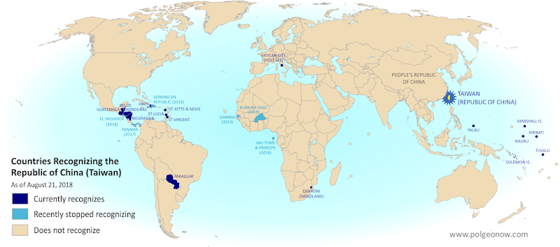
Map of who recognizes Taiwan (what countries recognize the Republic of China) in August 2018. Marks countries that have cut diplomatic ties with Taiwan (withdrawn recognition) in the last ten years: El Salvador, Burkina Faso, the Dominican Republic, Panama, Sao Tome and Principe, and the Gambia. Also answers question: Where is Republic of China located? (Colorblind accessible)
Click to enlarge. By Evan Centanni, modified from public domain blank world map.
Contact us for permission to use this map.

Article by Evan Centanni

El Salvador Drops Taiwan

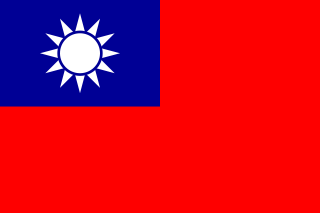
Flag of the Republic of China (Taiwan) Short Name (informal):  
• Taiwan (English)
• ROC (English)
• Táiwān (Chinese)
Official Name (in constitution):  
• Republic of China (English)
• Zhōnghuá Mínguó (Chinese)
Other names used officially:  
• “Republic of China (Taiwan)” (government offices)
• Chinese Taipei (international sports)
• Taiwan, Province of China (used by UN without Taiwan’s input)   
Capital: 
Taipei (de facto)
Claimed by: People’s Republic of China 

Disputed Taiwan lost its official endorsement from the Republic of El Salvador today. The small but densely-populated Central American country is cutting ties with Taiwan’s government in favor of setting up relations with Mainland China, becoming the latest to endorse the Mainland’s claim that Taiwan is part of China.

In a novel twist, reports said Taiwan’s government “pre-emptively” cut ties with El Salvador just hours before the Salvadoran government publicly announced the switch. But the move was still based on a decision by El Salvador, which Taiwan officials said had been holding talks on the possibility since June.

Is Taiwan a Country?

The islands of Taiwan operate like an independent country today, but are governed under the constitution of the “Republic of China” (ROC), the government that ruled Mainland China before the country’s communist revolution (the administration that now rules the Mainland is called the People’s Republic of China, or PRC).

Since 1991, Taiwan’s government has sought recognition separate from Mainland China in the UN, without challenging the PRC’s right to the Mainland. But because the Mainland government insists Taiwan can’t be separate, it cuts ties with any countries that set up relations with Taiwan, even if they want to stay friends with China too.

“Economic Reasons”

El Salvador’s government is calling its shift away from Taiwan the only reasonable choice in a world where China is one of the most powerful economies, saying that it will bring more opportunities in the future. El Salvador has never before had diplomatic relations with the PRC. Alluding to the fact that the ROC no longer governs most of China, a Salvadoran spokesman was quoted as saying, “El Salvador can’t turn its back on international reality.”

Taiwan’s government, on the other hand, described more specific motivations. The disputed country’s foreign minister accused El Salvador’s president of asking Taiwan to fund his re-election campaign, and said the Salvadoran government had also backing for an expensive port construction project that would have left both countries in debt. (Some speculate that if China steps in to fund the port, it could eventually host the first Chinese military base in the Americas.)

Though Taiwan’s dwindling list of diplomatic contacts may not be a critical threat to its self-governing status, these changes are not merely symbolic. Even aside form the economic ramifications for El Salvador, many average people on both sides may be affected. For example, Salvadoran students in Taiwan are about to see their studies cut short, being forced to either transfer to Mainland China or return home.

Learn More: What Exactly is Taiwan, and Do Countries Really “Recognize” It?

Republic of China: Shrinking Recognition

Today, only 17 countries in the world (about 9%) still have formal diplomatic relations with the Taiwan-based “Republic of China” government – the closest equivalent to officially “recognizing” Taiwan as a country. That includes 16 United Nations (UN) member countries plus UN observer state Vatican City.

El Salvador is the fifth country to drop Taiwan since the current ROC president, whose platform involves resisting Mainland Chinese influence, took office in 2016. Before El Salvador, the last four countries to switch to China were the Dominican Republic and Burkina Faso this May, Panama in June 2017, and São Tomé and Príncipe in December 2016.

Only one country, the Gambia, abandoned Taiwan between 2008 and 2016, during a “diplomatic truce” initiated by Taiwan’s most Mainland-friendly president (even then, the PRC waited until Taiwan elected its current president before restoring its own relations with the Gambia).

Graphic of the Republic of China (Taiwan) flag is in the public domain (source).

Map: Which Countries “Recognize” Taiwan?

This map and explainer will be updated whenever there’s a change to the list of Taiwan’s “diplomatic allies”. You can find articles on each change by scrolling to the bottom of this page, or by viewing all Taiwan articles on PolGeoNow.

Map of who recognizes Taiwan (what countries recognize the Republic of China) in August 2018. Marks countries that have cut diplomatic ties with Taiwan (withdrawn recognition) in the last ten years: El Salvador, Burkina Faso, the Dominican Republic, Panama, Sao Tome and Principe, and the Gambia. Also answers question: Where is Republic of China located? (Colorblind accessible)
Click to enlarge. By Evan Centanni, modified from public domain blank world map.
Contact us for permission to use this map.

Is Taiwan a Country?

At PolGeoNow we frequently report on self-proclaimed, unrecognized or partially-recognized countries – but Taiwan is a special case. It operates like an independent country today, but has never formally declared independence. Instead, Taiwan and its surrounding islands govern themselves as the “Republic of China” (ROC), under a constitution brought there by a former government of the Chinese mainland.

Flag of the Republic of China (Taiwan) Short Name (informal):  
• Taiwan (English)
• ROC (English)
• Táiwān (Chinese)
Official Name (in constitution):  
• Republic of China (English)
• Zhōnghuá Mínguó (Chinese)
Other names used officially:  
• “Republic of China (Taiwan)” (government offices)
• Chinese Taipei (international sports)
• Taiwan, Province of China (used by UN without Taiwan’s input)   
Capital: 
Taipei (de facto)
Claimed by: People’s Republic of China

Taiwan (ROC) vs. Mainland China (PRC)

Taiwan’s ROC government stands in contrast to the People’s Republic of China (PRC), which took the Mainland from the ROC in the Chinese Communist Revolution of the 1940s. The PRC government in Bejing never managed to take over Taiwan, but still insists that it will someday, saying the island is an inseparable part of China. It maintains delicate, semi-official relations with the ROC government in Taipei, but fiercely opposes any move toward formal Taiwanese independence.

Taiwan’s ROC government also claimed ownership of all China at one time, when it was ruled under martial law by Chiang Kai-shek‘s Chinese Nationalist Party (Kuomintang, or KMT). But with democracy now in place, and fewer and fewer Taiwanese people thinking of themselves as Chinese, recent administrations have backed off from those claims.

In fact, many of Taiwan’s politicians support increased acknowledgement of independence, but so far no administration has been willing to risk war with Mainland China by issuing a full-on independence declaration.

Who “Recognizes” Taiwan?

Until the 1970s, the Taiwan’s ROC government held onto China’s seat in the United Nations (UN), and was considered China’s rightful government by the majority of the world’s countries. But after the UN General Assembly deposed it and replaced it with the PRC in 1971, the tables turned quickly.

Today, only 17 countries in the world (about 9%) still have formal diplomatic relations with the Taiwan-based ROC government, including 16 UN member countries plus UN observer state Vatican City. All of them are marked on the map above, along with all countries that have cut diplomatic ties with the ROC within the last ten years.
 
Now, recognizing a government doesn’t technically have the same legal meaning as recognizing a country. Officially, everyone recognizes China as a country, but they disagree over whether the ROC or PRC administration is China’s government. That means that when we talk about countries “recognizing” Taiwan, it’s not technically the same thing as when countries recognize Kosovo or Palestine.

To illustrate that point: A country that recognizes Kosovo as a country independent from Serbia normally continues to recognize Serbia as a country too. But in the case of China and Taiwan, countries are forced to pick one or the other. Because the Mainland government insists Taiwan can’t be separate, it cuts ties with any countries that set up relations with Taiwan, even if they want to stay friends with China too.

Still, saying that a country with diplomatic ties to the ROC “recognizes Taiwan” is a useful practical analogy, since Taiwan now strives to be something more like a self-declared country than a rival government of China. In fact, after 1991 Taiwan’s government requested a seat separate from Mainland China in the UN, accepting the PRC’s right to rule the Mainland even while making sure not to declare outright independence.

North and South Korea have an arrangement just like that, both technically claiming to be governments of Korea while still allowing each other to have separate recognition and UN seats. But because the PRC sees Taiwan its subordinate, not its equal, it has blocked any similar deal from happening.

Taiwan Recognition News on PolGeoNow

Since 2017, PolGeoNow has been bringing you ongoing coverage of all events effecting the recognition of Taiwan. News articles about these changes are listed here:

Map of who recognizes Taiwan (what countries recognize the Republic of China) in August 2018. Marks countries that have cut diplomatic ties with Taiwan (withdrawn recognition) in the last ten years: El Salvador, Burkina Faso, the Dominican Republic, Panama, Sao Tome and Principe, and the Gambia. Also answers question: Where is Republic of China located? (Colorblind accessible)El Salvador Switches Recognition from Taiwan to China
Taiwan and El Salvador cut ties in August 2018, amid accusations of unreasonable Salvadoran financial demands.

Full map and article

Map of who recognizes Taiwan (what countries recognize the Republic of China) in June 2018. Marks countries that have cut diplomatic ties with Taiwan (withdrawn recognition) in the last ten years: Burkina Faso, the Dominican Republic, Panama, Sao Tome and Principe, and the Gambia. Also answers question: Where is Republic of China located? (Colorblind accessible)Taiwan Loses Dominican Republic, Burkina Faso Recognition
In May 2018, two more countries cut ties with Taiwan in favor of relations with Mainland China, both under financial pressure.

Full map and article

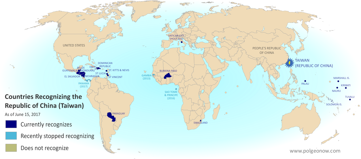
Map of who recognizes Taiwan (what countries recognize the Republic of China) in June 2017. Marks countries that have cut diplomatic ties with Taiwan (withdrawn recognition) in the last ten years: Panama, Sao Tome and Principe, and the Gambia. Also answers question: Where is Republic of China located? (Colorblind accessible)Panama Recognizes China, Stops Recognizing Taiwan
In 2017, the Central American republic of Panama became the second country to cut ties with Taiwan since an eight-year “diplomatic truce” between the ROC and PRC ended in 2016.

Full map and article


Graphic of the Commonwealth flag is displayed under fair use principles (source).

Taiwan Loses Recognition from Dominican Republic, Burkina Faso (Map)

You can always find the latest version of this map, and a list of all related articles, on our Which Countries Recognize Taiwan? page.

Map of who recognizes Taiwan (what countries recognize the Republic of China) in July 2018. Marks countries that have cut diplomatic ties with Taiwan (withdrawn recognition) in the last ten years: Burkina Faso, the Dominican Republic, Panama, Sao Tome and Principe, and the Gambia. Also answers question: Where is Republic of China located? (Colorblind accessible)
Click to enlarge. By Evan Centanni, modified from public domain blank world map.

Article by Evan Centanni

Dominican Republic, Burkina Faso Drop Taiwan

Flag of the Republic of China (Taiwan) Short Name (informal):  
• Taiwan (English)
• ROC (English)
• Táiwān (Chinese)
Official Name (in constitution):  
• Republic of China (English)
• Zhōnghuá Mínguó (Chinese)
Other names used officially:  
• “Republic of China (Taiwan)” (government offices)
• Chinese Taipei (international sports)
• Taiwan, Province of China (used by UN without Taiwan’s input)   
Capital: 
Taipei (de facto)
Claimed by: People’s Republic of China 

This past May, disputed Taiwan lost its official endorsements from both the Dominican Republic in the Caribbean, and Burkina Faso in West Africa. The two countries have cut ties with Taiwan in favor of setting up official relations with Mainland China, endorsing the Mainland’s claim that Taiwan is part of China.

The islands of Taiwan operate like an independent country today, but are governed under the constitution of the “Republic of China” (ROC), the government that ruled Mainland China before the country’s communist revolution (the administration that now rules the Mainland is called the People’s Republic of China, or PRC).

Since 1991, Taiwan’s government has sought recognition separate from Mainland China in the UN, without challenging the PRC’s right to the Mainland. But because the Mainland government insists Taiwan can’t be separate, it cuts ties with any countries that set up relations with Taiwan, even if they want to stay friends with China too.

The Dominican Republic announced it was cutting ties with Taiwan on May 1, 2018, saying the reason was “history and socioeconomic reality”. This reality allegedly includes the equivalent of $3.1 billion US dollars in investments and loans from China, though the Dominican government only mentioned future tourism opportunities as an example.

Burkina Faso followed on May 24, even though it had just co-sponsored Taiwan’s bid to become an observer at World Health Organization (WHO) meetings. The Burkinabe government also cited “socio-economic challenges” and the “evolution of the world” as the reasons for its switch.

Learn More: What Exactly is Taiwan, and Do Countries Really “Recognize” It?

Republic of China: Shrinking Recognition

Today, only 18 countries in the world (about 9%) still have formal diplomatic relations with the Taiwan-based “Republic of China” government – the closest equivalent to officially “recognizing” Taiwan as a country. Before the Dominican Republic and Burkina Faso cut ties in May, the last two countries to drop Taiwan in favor of the PRC were Panama in June 2017 and São Tomé and Príncipe in December 2016.

Only one country, the Gambia, abandoned Taiwan between 2008 and 2016, during a “diplomatic truce” initiated by Taiwan’s most Mainland-friendly president (even then, the PRC waited until Taiwan elected a more independence-leaning president before restoring its own relations with the Gambia).

Taiwan’s last remaining “diplomatic ally” in Africa is tiny Eswatini (Swaziland), whose king recently promised not to follow Burkina Faso in switching to the PRC. Supporters of a separate Taiwan worry their next loss might be the Holy See, government of the Catholic Church’s independent Vatican City in Rome. The Vatican has recently been working to patch up its bad relationship with the Mainland Chinese government.

Learn More: What’s the difference between Vatican City and the Holy See?

Graphic of the Republic of China (Taiwan) flag is in the public domain (source).

Panama Recognizes China, Stops Recognizing Taiwan (Map)

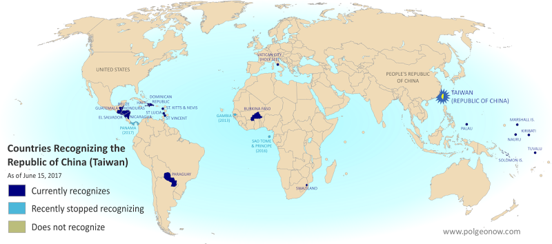
There are newer versions of this map available. You can always find the latest version, and a list of all related articles, on our Which Countries Recognize Taiwan? page.

Map of who recognizes Taiwan (what countries recognize the Republic of China) in June 2017. Marks countries that have cut diplomatic ties with Taiwan (withdrawn recognition) in the last ten years: Panama, Sao Tome and Principe, and the Gambia. Also answers question: Where is Republic of China located? (Colorblind accessible)
Click to enlarge. By Evan Centanni, modified from public domain blank world map.

Article by Evan Centanni

Taiwan Loses Recognition from Panama

Flag of the Republic of China (Taiwan) Short Name (informal):  
• Taiwan (English)
• ROC (English)
• Táiwān (Chinese)
Official Name (in constitution):  
• Republic of China (English)
• Zhōnghuá Mínguó (Chinese)
Other names used officially:  
• “Republic of China (Taiwan)” (government offices)
• Chinese Taipei (international sports)
• Taiwan, Province of China (used by UN without Taiwan’s permission)   
Capital: 
Taipei (de facto)

The Central American country of Panama announced this Tuesday that it’s cutting diplomatic relations with Taiwan. Instead, it’s setting up official ties with Mainland China, endorsing the Chinese claim that Taiwan is part of China.

The island of Taiwan operates like an independent country today, but is governed under the constitution of the “Republic of China” (ROC), the government that ruled Mainland China before the communist revolution (the government that now rules the Mainland is called the People’s Republic of China).

Because the China-Taiwan dispute was originally over which side was the rightful government of China, and because the now-powerful Mainland government insists Taiwan can’t be a separate country, other countries have to choose to recognize just one or the other.

This is the first time Panama has ever recognized the People’s Republic of China, having maintained relations with the Republic of China ever since it was founded in 1912 (long before the ROC government moved to Taiwan).

Republic of China: Shrinking Recognition

Today, only 20 countries (about 10%) still have formal diplomatic relations with the Taiwan-based Republic of China government – the closest equivalent to “recognizing” Taiwan as a country. Before Panama cut ties this week, the last country to switch from Taiwan to China was São Tomé and Príncipe last December.

Only one country, the Gambia, abandoned Taiwan between 2008 and 2016, during a “diplomatic truce” initiated by Taiwan’s most Mainland-friendly president (even then, China waited until Taiwan elected a more independence-leaning president before restoring its own relations with the Gambia).

Graphic of the Republic of China (Taiwan) flag is in the public domain (source).
Japan-China Dispute: The Eight Islands of the Senkaku/Diaoyu Group (Aerial Photos)

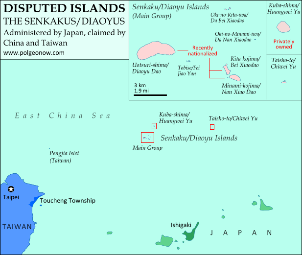
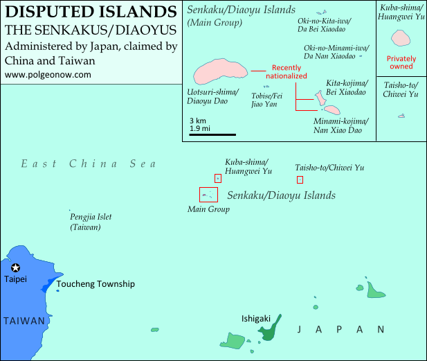
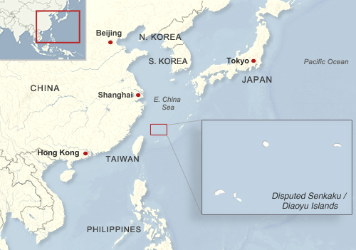
Map of the Senkaku/Diaoyu Islands, disputed between Japan, China, and Taiwan; includes location as well as detail of islands
Map of the disputed Senkaku/Diaoyu Islands (by Evan Centanni). Click to view at full size.

Article by Evan Centanni

The Senkaku/Diaoyu Islands
A recent feature on Political Geography Now introduced the history and status of the Senkaku/Diaoyu Islands, a disputed territory controlled by Japan but claimed by China and Taiwan. The article included an original map which showed the isles’ configuration and precise location within the East China Sea (click on the map at right to see it at full size). But if you’re like me, you may be wondering “just how small are these islands, and what do they really look like?”

Luckily for you and me, aerial photographs of many places in Japan have been released by the Japanese government and uploaded with English labels to Wikimedia Commons. Included in the collection are shots of each of the disputed isles, known as the Senkaku Islands to the Japanese, the Diaoyu Islands to the Chinese, and the Diaoyutai Isands to the Taiwanese. Here are the photos and a brief profile of each island:

Aerial photo of Uotsuri-shima (魚釣島)/Diàoyúdǎo (钓鱼岛)/Diàoyútái (釣魚臺), the largest of the Senkaku/Diaoyu islands disputed between Japan, China, and Taiwan

Japanese: Uotsuri-shima (魚釣島)
Chinese (China): Diàoyúdǎo (钓鱼岛)
Chinese (Taiwan): Diàoyútái (釣魚臺)
Area: 4.32 km2 (1.67 mi2)
Highest Point: 383 m (1,257 ft.)
The largest isle in the disputed archipelago, Uotsori has been a center of historical activity in the Senkaku/Diaoyu Islands. It was the site of a Japanese fish-processing plant from about 1900-1940, when it hosted 200 workers. Since then it has been uninhabited, but was visited by a Japanese academic-governmental delegation for four weeks in 1979.

The island was one of four sold to the Kurihara family in the 1970s. The Japanese government rented the island from 2002, before finally buying it from the family last year. Though the island is no longer inhabited by humans, it is home to a population of domestic goats and albatross, as well as a species of mole found nowhere else on earth. Once called “Peaks Island” by the British, the current name means “Fishing Island” in both Japanese and Chinese (the name used by Taiwan is literally “Fishing Platform”). (photo source)

Aerial photo of Kita-kojima (北小島)/Běi Xiǎodǎo (北小島/北小岛) and Minami-kojima (南小島)/Nán Xiǎodǎo (南小島/南小岛), two major parts of the Senkaku/Diaoyu Islands disputed between Japan, China, and Taiwan

Japanese: Kita-kojima (北小島)
Chinese: Běi Xiǎodǎo (北小島/北小岛)
Area: 0.33 km2 (0.13 mi2)
Highest Point: 135 m (443 ft.)

Japanese: Minami-kojima (南小島)
Chinese: Nán Xiǎodǎo (南小島/南小岛)
Area: 0.46 km2 (0.18 mi2)
Highest Point: 149 m (489 ft.)
These are the only other major islands in the main cluster of the Senkakus. Like Uotsuri, they were sold to the Kurihara family in the 1970s, rented by the Japanese government from 2002, and bought by the government in 2012. The islands’ names are written the same in both Japanese and Chinese, and mean “Northern Little Island” and “Southern Little Island” respectively. (photo source

Aerial photo of Oki-no-Kita-iwa (沖の北岩)/Běiyǔ (北屿)/Chōng Běiyán (沖北岩)/Dà Běi Xiǎodǎo (大北小島)/Běiyán (北岩), group of rocks which form part of the Senkaku/Diaoyu Islands disputed between Japan, China, and Taiwan

Japanese: Oki-no-Kita-iwa (沖の北岩)
Chinese (China): Běiyǔ (北屿)
Chinese (Taiwan): Chōng Běiyán (沖北岩)
Other Chinese Names: Dà Běi Xiǎodǎo (大北小島), Běiyán (北岩)
Area: 0.02 km2 (0.01 mi2)
Highest Point: 28 m (92 ft.)
This is actually a small group of islets located in the northeast of the Senkaku Islands’ main cluster. It consists mainly of barren rocks, and has apparently never been privately owned. The Japanese and various Chinese names are variations on “Northern Islet” or “Northern Rock”; yet one name, Dà Běi Xiǎodǎo, means “Big Northern Little Island”, seeming ironically to imply that it outsizes the much larger Běi Xiǎodǎo (Kita-kojima). (photo source

Aerial photo of Oki-no-Minami-iwa (沖の南岩)/Nányǔ (南屿)/Chōng Nányán (沖南岩)/Dà Nán Xiǎodǎo (大南小島)/Nányán (南岩), group of rocks which form part of the Senkaku/Diaoyu Islands disputed between Japan, China, and Taiwan

Japanese: Oki-no-Minami-iwa (沖の南岩)
Chinese (China): Nányǔ (南屿)
Chinese (Taiwan): Chōng Nányán (沖南岩)
Other Chinese Names: Nán Běi Xiǎodǎo (大南小島), Nányán (南岩)
Area: 0.005 km2 (0.002 mi2)
Highest Point: 13 m (43 ft.)
Located at the eastern edge of the main cluster of the Senkaku Islands, this another barren rock which has apparently never been privately owned. Its names in Japanese and Chinese present it as the southern counterpart to Oki-no-Kita-iwa. (photo source)

Aerial photo of Tobise (飛瀬)/Fēiyǔ (飞屿)/Fēilài (飛瀨)/Fēiyán (飛岩)/Fēijiāoyán (飛礁岩), a reef which forms part of the Senkaku/Diaoyu Islands disputed between Japan, China, and Taiwan

Japanese: Tobise (飛瀬)
Chinese (China): Fēiyǔ (飞屿)
Chinese (Taiwan): Fēilài (飛瀨)
Other Chinese Names: Fēiyán (飛岩), Fēijiāoyán (飛礁岩)
Area: 0.0008 km2 (0.0003 mi2)
Highest Point: 2 m (7 ft.)
Tobise is a cluster of rocks located just southeast of Uotsuri, the biggest island of the Senkakus. Although the area of shallow water surrounding it gives it a larger profile on some maps, according to the Taiwan government’s measurements it is the smallest of the eight major named isles of the Senkaku/Diaoyu Islands. It is also the lowest, protruding little farther above the water than the height of a person. Its Japanese and Chinese names all translate to something like “flying shoals” or “flying reef”. (photo source)

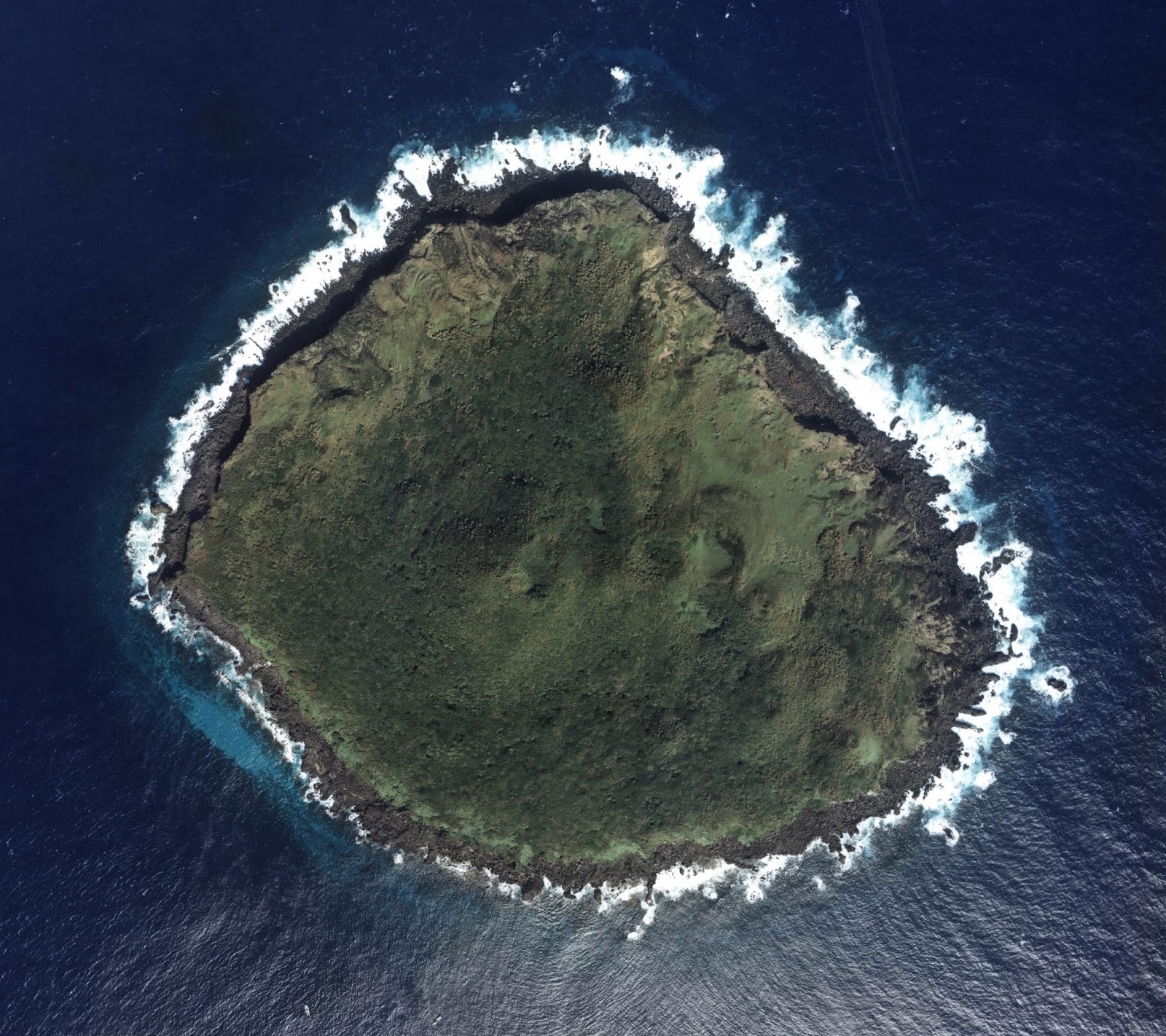
Aerial photo of Kuba-shima (久場島)/Huángwěiyǔ (黃尾嶼/黄尾屿), one of the Senkaku/Diaoyu Islands disputed between Japan, China, and Taiwan

Japanese: Kuba-shima (久場島)
Chinese: Huángwěiyǔ (黃尾嶼/黄尾屿)
Area: 1.08 km2 (0.42 mi2)
Highest Point: 117 m (384 ft.) Kuba is the second largest of the Senkaku Islands, located to the north of the main cluster. In the 1970s, it was sold to the Kurihara family along with the three major islands of the main group, but was owned by the sister of the man who the other three belonged to. Today it is still owned by the family, but rented by Japan’s Ministry of Defense. The Japanese in turn allow the U.S. military to use it as a practice bombing range for aircraft. “Kuba” is a Japanese surname, and the Chinese name means “Yellow-tail Islet”. (photo source)

Aerial photo of Taishō-to (大正島)/Chìwěiyǔ (赤尾嶼/赤尾屿), one of the Senkaku/Diaoyu Islands disputed between Japan, China, and Taiwan

Japanese: Taishō-to (大正島)
Chinese: Chìwěiyǔ (赤尾嶼/赤尾屿)
Area: 0.06 km2 (0.02 mi2)
Highest Point: 75 m (246 ft.)
Taisho is the most distant of the Senkaku/Diaoyu Islands, located over 100 km (60 mi) to the east of the main group. A relatively high island for its size, it has been continuously owned by the Japanese government since Japan formally took possession of the islands in 1895. In Japanese, the island is probably named after Emperor Taishō, the Emperor of Japan at the time when the Senkakus were annexed and developed. The Chinese name means “Red-tail Islet”. (photo source)

(Photos from Wikimedia Commons, based on National Land Image Information (Color Aerial Photographs), Ministry of Land, Infrastructure, Transport and Tourism of Japan. Used under terms of copyright.)

Related Articles:

Niger and Burkina Faso Resolve Territorial Dispute

Disputed Territory: The Senkaku/Diaoyu Islands

You may have heard the news about China and Japan’s ongoing territorial dispute over a group of islands in the East China Sea. But what are the Senkaku/Diaoyu Islands, and why are they so fiercely contested? Read on for all these answers and more!

Map of the Senkaku/Diaoyu Islands, disputed between Japan, China, and Taiwan; includes location as well as detail of islands
Map of the disputed Senkaku/Diaoyu Islands (by Evan Centanni).

Article by Omar Alkhalili

About the Islands
The Senkaku/Diaoyu Islands are a collection of five small islets and three rocks in the East China Sea, all of which are uninhabited. The largest of the islands has an area of 4.32 km² and the smallest is only 0.45 km². They are located about 140 km from the nearest inhabited Japanese islands, 300 km from mainland China and 170 km from Taiwan. They are administered by Japan but claimed by both the People’s Republic of China (PRC) and Taiwan, whose government is known officially as the Republic of China (ROC).

Map of the location of the disputed Senkaku/Diaoyu Islands within Asia
Location of the disputed Senkaku/Diaoyu Islands in Asia
Public domain graphic (source)

In English, the islets have historically been referred to as the Pinnacle Islands, but are now more often called by their Japanese and Chinese names. In Japan, they are known as the Senkaku Islands, whereas in mainland China they are called the Diaoyu Islands and in Taiwan they are referred to as the Diaoyutai (Tiaoyutai) Islands. They are administered by Japan as part of Ishigaki, a municipality in Okinawa Prefecture, while the PRC and ROC both consider them part of Toucheng township in Taiwan’s Yilan County, despite the fact that the two rival governments do not recognize each other.

While it considers the islands part of Ishigaki, Japan’s central government does not allow the city to develop or survey them. Four of the islands have been privately owned since 1932, but the government bought three of them last year after renting them for some time. One of the privately owned islands is still leased to the Japanese Ministry of Defense, which has allowed the United States military to use it as a practice bombing range for aircraft.

History of Claims and Control

Territory Name:  
Senkaku-shotō (Japanese)
• Diàoyúdǎo (Mandarin – China)
• Diàoyútái (Mandarin – Taiwan)
Pinnacle Islands (English – historical) 
Claimants: 
• Japan
• China (People’s Republic of China)
• Taiwan (Republic of China)
Actual Control: Japan
Administrative Status: Part of the country
Capital: N/A (uninhabited)

Japan, mainland China and Taiwan all root their claims to the Senkakus/Diaoyus in the region’s history. China was aware of the islands’ existence since the 15th century, and the PRC and ROC claim that the islands have been part of Chinese territory since at least the 16th century. However, the Japanese government holds that when it surveyed the islands in the late 1800s, they were uninhabited and showed no signs of having been under Chinese administration.

Japan took control of the islands in 1895, and with the exception of the American occupation of Japan from 1945 to 1972, has held onto them ever since. Both Chinas now consider the islands to be part of Taiwan province, which China ceded to Japan in 1895 after the First Sino-Japanese War. However, they hold that Japan returned the rights to the islands to China by surrendering to the Allied Powers at the end of World War II. Japan insists that these islands were not part of the territory that it gave up in surrendering, arguing that they were always considered part of the Ryukyu island chain rather than Taiwan. China and Taiwan did not voice their claim to the Senkaku/Diaoyu islands until after the U.S. occupation Okinawa ended in 1972.

On top of the historical claims, various economic issues complicate the dispute. The islands’ territorial waters include rich fishing grounds and lie along the path of strategically important shipping lanes. Potential oil reserves have also been identified nearby.

Current Dispute
In recent years, tensions over the Senkaku/Diaoyu Islands have flared between Japan and both Chinese governments. After a series of incidents in 1996 that included Japanese activists installing a light house on one of the islands and the death of a Chinese activist due to drowning, there have been continued instances of Chinese activists attempting to sail to the islands, resulting in their arrest and detention.

Aerial view of two of the Senkaku/Diaoyu Islands disputed between Japan, China, and Taiwan
Aerial photo of Kita-kojima/Bei Xiaodao and Minami-kojima/Nan Xiaodao in the Senkaku/Diaoyu Islands
(Courtesy of Japan National Land Image Information (Color Aerial Photographs, Ministry of Land, Infrastructure, Transport and Tourism; source)

In 2010, an incident involving the detention of a Chinese ship crew precipitated mass protests in Chinese cities. Two years later, before the Japanese government’s purchase of three of the islands, the then Governor of Tokyo came up with his own plan to buy the islands, sparking protests in China and resulting in the detention of a group of activists from Hong Kong. Mainland China has challenged Japanese control of the islands through incursions into their territorial waters and airspace. In 2013, the mainland government announced that it plans to survey the islands in order to safeguard its maritime interests.

Recently, some progress has been made in resolving the dispute, with Japan and Taiwan arriving at an agreement allowing Taiwanese fishermen access to a large portion of the island’s surrounding waters. This agreement may create an obstacle for mainland China as its government becomes isolated in its efforts to challenge Japanese control. However, Taiwan still retains its claims to the Senkakus/Diaoyus, and there is no clear end in sight for the dispute between the three governments.

Omar Alkhalili is a contributor to Political Geography Now. He is a graduate of Ramapo College of New Jersey with a Bachelor of Arts Degree in Political Science. He can be reached at omaralkha@gmail.com.

See Also: The Eight Islands of the Senkaku/Diaoyu Group (profiles and aerial photos)

Related Articles:

Niger and Burkina Faso Resolve Territorial Dispute

Partner Project: Range of Taiwan’s Missiles

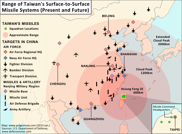
Map of Taiwan's missile capabilities, created for Taiwan in Perspective (https://michalthim.wordpress.com)
Click to see at full size on Taiwan in Perspective blog.
Map by Evan Centanni (all rights reserved).

Michal Thim from Taiwan in Perspective recently asked Political Geography Now to help him make a map depicting Taiwan’s current and future missile capabilities in its standoff with China. For anyone who’s interested, here’s the finished product (click on the map to see it at full size on Michal’s site). The main sources for the missile information was this article from Defense News, and the locations of China’s military assets come from the U.S. Department of Defense’s 2012 annual report on China.

If you want to learn more about the complex political situation in Taiwan, Wikipedia has a decent outline of the basics. Political Geography Now also hopes to publish maps and articles covering Taiwan in the future.