Libyan Civil War Map & Timeline – July 2018

To see more maps in this series, view all Libya articles.

Libya: Who controls what? A concise, professional map of of who controls Libya now (July 2018). Shows detailed territorial control in the Libyan Civil War as of July 19, 2018, including all major parties (Government of National Accord (GNA); Tobruk House of Representatives, General Haftar's Libyan National Army (LNA), and allies; Tuareg and Toubou (Tebu) militias in the south; the so-called Islamic State (ISIS/ISIL); and other groups such as the National Salvation Government(NSG) and religious hardline groups). Includes terrain and major roads. Colorblind accessible.
Base map by Koen Adams of onestopmap.com, with territorial control by Evan Centanni. All rights reserved.

(Subscribers click here to view this article on the member site)

Timeline by Djordje Djukic

Libya: Who Controls What?

Ten months after our previous Libya control map and report, the country remains divided between two major rival governments and several smaller groups, but there have been a few changes to their areas of control. This is the first free edition of our map that also shows the territories of the Toubou and Tuareg militias in Libya’s south, which align on and off with the country’s two major governments.

(Toubou and Tuareg are two non-Arab ethnic groups residing in southern Libya and neighboring parts of the Sahara Desert – the armed coalitions shown on the maps are formed by and for members of those peoples, but not all Toubou and Tuareg people are affiliated with them.)

Maybe the biggest change to Libya’s political geography situation since last year has been the Toubou militias’ realignment. Until this May, they were loosely allied with the eastern government’s “Libyan National Army” (LNA), but after the LNA began supporting their opponents in the city of Sabha, they turned against the eastern government and have leaned more towards the western government in Tripoli.

Also, just last month, the LNA eliminated an enclave of rival control in eastern city of Derna, which had been controlled by an independent armed group often accused of having ties to Al Qaeda.

For a full explanation of Libya’s rival governments and major armed groups, including the history of the current civil war since the fall of Muammar Gaddafi in 2011, see our detailed Libya background article and timeline from August 2015. You can see subsequent updates from 2015 to present by viewing all Libya articles.

Flag of Libya (2011-present)Country Name:  
• Libya (English)
• Lībyā (Arabic)
Official Name:  
• State of Libya (English)
Dawlat Lībyā (Arabic) 
Capital: Tripoli

Timeline of Events

The following is a detailed timeline of major political events and changes to territorial control since our previous Libya map report of September 20, 2017.

September 21 – October 6, 2017
Clashes resumed between two opposing groups in Sabratha, west of Tripoli, after negotiations collapsed. The fighting pitted a group called the Anti-ISIS Operations Room (AIOR) and its allies on one side, against the Anas al-Dabbashi brigade, which had been called major facilitator of migrant smuggling, but recently said it had reached a deal with the UN-backed Government of National Accord (GNA) in Tripoli to stop boats from leaving to Europe across the Mediterranean sea.

The al-Dabbashi brigade said it was targeted by opponents who wanted to continue smuggling, while the AIOR claimed its rivals were “jihadists”. Some reports said the fighting came as a result of an Italian-backed deal to fund militias as police forces against migrants. On 23 September, the AOIR captured the downtown Qamar Hotel, while on 28 September, it seized the famous Sabratha Roman ruins, a UNESCO world heritage site. On October 6, the AOIR took full control of Sabratha.

Both the GNA and the Benghazi-based Libyan National Army (LNA) have claimed links to the AOIR and both welcomed the group’s capture of the city. The three weeks of fighting left at least 43 people dead and 340 wounded.

November 5, 2017
After holding out for four months in Benghazi, the last fighters of the religious hardline Benghazi Revolutionaries’ Shura Council (BRSC) in the city came under renewed attack from the LNA. Airstrikes were carried out against the fighters for the first time in weeks, along with a ground assault, after the LNA abandoned its attempts to starve them out. It was said only a few buildings remained under BRSC control. However, the LNA’s assault met with stiff resistance.

November 5-8, 2017
Brigades loyal to both the GNA and the LNA started a joint operation in a western district of Tripoli against alleged criminal elements, as well as a militia loyal to deceased Libyan leader Muammar Gaddafi. The district was seized three days later.

November 11, 2017
It was reported that the Sidi Akribesh neighborhood of Benghazi, the location of the BRSC holdouts, had come under control of the LNA. However, two days later, it was confirmed that fighting in the neighborhood was still continuing.

December 15, 2017
It was reported that 10 BRSC fighters and 7 LNA soldiers had been killed in fighting in Benghazi in November.

December 28-30, 2017
The LNA announced it had taken full control of Benghazi’s Sidi Akribesh neighborhood from the hardline fighters. However, the following day, it was said that clearing operations were still continuing in the area. The area was secured and the operations concluded on December 30, after five hardline fighters were killed. Overall, 17 LNA soldiers had been killed throughout December in the clashes, while another 76 had been wounded. Some reported that remaining BRSC fighters managed to retreat to Derna, the LNA denied this.

January 15, 2018
The Mitiga airport in Tripoli was shut down after a GNA-allied group repelled an attack by a rival militia. Several planes at the airport were damaged in the fighting, which left at least 20 people dead.

January 23, 2018
Twin car bombings targeting the Bayaat al-Radwan mosque in Benghazi left 35 people dead. Senior security officers were among the casualties, including Ahmed al-Feitouri, head of the LNA’s investigations and arrests unit.

February 4-March 2, 2018
Fighting erupted in the southern city of Sabha between the Sixth Brigade, composed of members of the Awlad Suleiman tribe, and Toubou militias. The Sixth Brigade had up to then supported the GNA, while the Toubous were nominally linked to the LNA. However, the GNA-loyal commander of the Sixth Brigade was eventually replaced by an LNA commander, after which eastern tribal elders tasked with mediating a truce in Sabha declared the Sixth to be a LNA unit.

The LNA then began providing support to the Sixth Brigade, which the GNA had not previously delivered, and the brigade used this to press its advantage against the Toubou militias. The walls of the historic Sabha castle were severely damaged by missile fire during the fighting.

February 24, 2018
A reconciliation agreement was reached between the Toubou and the Zawia tribe in Kufra. The two groups had previously clashed in late 2015. The agreement called for the establishment of a neutral security force in the town.

March 6, 2018
Fighting was temporarily renewed in Sabha, before the situation calmed down again.

March 15, 2018
The first LNA units from Benghazi arrived in Kufra to secure the town. The local LNA unit was mostly made up of members of the Zawia tribe, which had previously been involved in fighting against the Toubou.

April 2, 2018
Sabha’s castle was once again hit by rocket fire.

May 2, 2018
Suicide bombers loyal to the so-called “Islamic State” (IS; formerly ISIS/ISIL) attacked the High National Elections Commission in Tripoli, killing 16 people. Meanwhile, Kufra’s tribes vowed support for the LNA.

May 5, 2018
Fighting was renewed in Sabha. Overall, 18 people had been killed and 86 injured, mostly civilians, since the clashes in the city began in February.

May 7-8, 2018
The LNA launched an assault on the city of Derna, held by the allegedly religious-hardline Derna Mujahideen Shura Council (DMSC), with clashes erupting in the eastern Fatayeh district. The next day, the LNA captured a point of high ground outside Derna.

May 11, 2018
The DMSC dissolved itself and announced the creation of the Derna Protection Force (DPF), which it said would a moderate group under the command of anti-LNA Libyan army officers. The DMSC was widely considered a religious hardline group with links to Al Qaeda, but its leaders claimed this was a lie spread by the LNA’s General Haftar.

May 12-13, 2018
After a new LNA governor arrived in Sabha, he declared a ceasefire between the Sixth Brigade and the Toubou. At this point the Toubou coalition, which had been drifting away from the LNA, demanded that the new governor say whether the Sixth was an LNA unit. After he confirmed that it was, the Toubou declared war on the LNA and launched a large attack, capturing the Sabha castle.

The castle was temporarily recaptured by the Sixth Brigade before the Toubou fighters once again seized it, along with the Sixth’s headquarters, the next day. The Toubou coalition also reopened the road to northern Libya and called on the GNA to secure the city. Since the beginning of May, 31 people had been killed in the fighting in Sabha.

May 15, 2018
The DPF withdrew from the Heela district of Derna.

May 28, 2018
The LNA captured two southwestern suburbs of Derna.

May 31, 2018
It was reported that since the start of the battle for Derna, 20 LNA soldiers had been killed and 35 wounded. The LNA also estimated that more than 100 DMSC/DPF fighters had died and another 100 had surrendered.

Meanwhile, an armed group attacked and briefly captured Tamenhint Airbase, northeast of Sabha. The attack was reportedly conducted by either the Benghazi Defence Brigades (BDB), a religious hardline militia, or the Toubou militias.

June 5, 2018
The LNA reached 75 percent control of Derna.

June 9-10, 2018
The LNA advanced in Derna’s Sheiha district up to the edge of the central Al-Maghar area after multiple airstrikes. This left less than 10 square kilometers remaining under DPF control.

June 14, 2018
A UK-based Arab human rights organization reported that since the start of the battle for Derna, 17 civilians had been killed and about 30 wounded.

June 14-16, 2018
The hardline Beghazi Defense Brigades (BDB) attacked and captured the Sidra and Ras Lanuf oil ports from the LNA. The LNA conducted a counterattack two days later, reporting that at least 20 BDB fighters and 14 LNA soldiers had been killed in the two-day clashes.

June 21-25, 2018
The LNA recaptured Sidra and Ras Lanuf. However, the BDB soon launched a counterattack. The BDB, which is said to have links with Al Qaeda, was also supported by mercenaries from the neighboring country of Chad. Four days later, the LNA fully secured the two oil terminals.

June 28, 2018
The LNA assumed full control of Derna after capturing the Al-Maghar district from the DPF. LNA sources said their next target would be gangs and foreign mercenaries in the southern city of Sabha.

Following this story? View all Libya maps on PolGeoNow.

Graphic of the Libyan flag is in the public domain (source).

Map: Costa Rica & Nicaragua Settle Border Dispute in Court

Conflicto Isla Portillos - mapa 2018. Map of Costa Rica and Nicaragua's post-2015 territorial dispute on Isla Portillos at the mouth of Rio San Juan, showing the judgment of the International Court of Justic (ICJ) of February 2018, based on the case filed in 2017. Includes key features such as Harbor Head Lagoon, the Nicaraguan military camp, the disputed territory along the beach, and the small water channels used to argue Nicaragua's case. Colorblind accessible.
Map by Evan Centanni, based on materials submitted to the court. Contact for usage permissions.

World Court Rules on Costa Rica vs. Nicaragua

What happens when two countries draw their border along a river, then the river changes course? The world got to find out yesterday, as the UN’s International Court of Justice (ICJ) released its judgement on a border dispute between Nicaragua and Costa Rica. Though the court’s ruling was dominated by a related request to define the two countries’ borders at sea, it also involved a tiny sliver of land in a temperamental river delta.

The Isla Portillos Dispute

The disputed land territory involves a slice of coastline at the northern tip of Isla Portillos, an island located in the delta of the River San Juan de Nicaragua (Isla Portillos is sometimes considered part of the larger Calero Island). The border once ran along the river and into a lagoon before hitting the Caribbean Sea, but a hundred years of natural changes to the area’s geography messed that all up.

In this court case – the latest of several between the two countries – Nicaragua claimed that a tiny channel of water still connected the river to the lagoon, separating a narrow strip of Nicaraguan coastline from the island’s Costa Rican interior. But Costa Rica argued that the channel, if it even existed, had been artificially built by Nicaragua, and that the Nicaraguan sandbar that once did exist had long ago eroded away. In this view, a small Nicaraguan military camp on the beach – recently moved from the mouth of the lagoon to a spot slightly farther west – was an illegal occupation of Costa Rican territory.

Flag of Costa Rica (civil)Country Name:  
• Costa Rica (English, Spanish)
Official Name:  
• Republic of Costa Rica (English)
• República de Costa Rica (Spanish)
Capital: San José

Costa Rica admitted that the lagoon itself, and the piece of beach now separating it from the sea, still belonged to Nicaragua, leaving a tiny piece of Nicaraguan territory separated from the rest of the country. Even so, Costa Rica warned that Nicaragua might even lose all of that if the beach erodes away completely (international law doesn’t normally allow a country to claim a body of water without owning some piece of land next to it).

Judgement Day: Who Owns the Beach on Isla Portillos?

When it released its decision this yesterday, the ICJ agreed with Nicaragua that the status of the disputed territory hadn’t already been decided by earlier court rulings. But in the end the judges sided almost entirely with Costa Rica, agreeing that the beach between the lagoon and the mouth of the river are Costa Rican. In a decision made by a vote of fourteen to two, Nicaragua was left with just the lagoon and its short strip of beach, and was ordered to move the military camp off of Costa Rican land.

In an unusual move, the court also decided that the sea just outside of the lagoon would be Costa Rican waters. Normally, any coastline controlled by a country automatically gives it the rights to at least some of the neighboring waters, and denying that to Nicaragua might turn out to be controversial.

The Story of a Border Dispute

The tale of the Isla Portillos dispute goes back almost 200 years, involving a US president, a Confederate general, and a lot of creative geographical analysis.

Costa Rica and Nicaragua declared independence from Spain together in 1821, and went their separate ways after the Federal Republic of Central America fell apart in 1838. But from early on, they scuffled over exactly which land belonged to which country. In 1858, they set out to end the disputes by precisely defining the course of their border in the Cañas–Jerez Treaty of Limits.

That treaty set the right bank of the San Juan River as the border in the Caribbean coastal area, with the boundary ending at a spot called Punta Castilla by the river’s mouth. After bringing in US President Grover Cleveland as a mediator from 1886 to 1888 to settle remaining disputes over the treaty’s validity, plus the exact location of Punta Castilla, the border seemed to be settled once and for all.

>Only one problem: Rivers change course over time. By 1896, when the Costa Rican and Nicaraguan governments set out to actually mark their border with pillars on the ground, the end of the San Juan River had split into three separate channels, hitting the ocean kilometers apart from each other. Naturally, each country chose whichever border interpretation gave it the most land, leaving the intervening islands disputed once again.

Map of the border between Nicaragua and Costa Rica at the Caribbean mouth of the San Juan River as decided by the 1897 Alexander award, including prior claims by each country. Includes Harbor Head Lagoon, the Taura Branch of the San Juan River, and the island now known as Isla Portillos.
Click to enlarge: Map of General Alexander’s 1897 border decision, and the Nicaraguan and Costa Rican claims of the time. The largest island, cut off by the Taura Branch, is Isla Portillos. Public domain illustration (source).

Still, it was no surprise that some disputes would come up in the process of marking out the border, and that’s why they had another third-party mediator on hand.

Grover Cleveland – US president again after a break from 1888-1893 – couldn’t participate in person, so instead he sent his friend Edward Porter Alexander, an engineer and former Confederate general from the US Civil War.

General Alexander decided the border should run as close as possible to the original Punta Castilla spot, now located at the northeastern corner of Harbor Head Lagoon on the San Juan’s middle channel. Realizing the river’s course would keep changing in the future, Alexander specified that the future border should always follow the east side of the lagoon and then continue up “the first channel met” into the San Juan River proper.

The Dispute Enters the 21st Century

Alexander’s solution continued to work for about a century. But over the decades Punta Castilla was swallowed by the sea (its original location now lies about a kilometer straight out to sea from the edge of the lagoon), and by the 2000s, another problem had come up: Harbor Head Lagoon wasn’t connected to the San Juan River at all anymore. Or was it?

Nicaragua claimed it had found a tiny channel through the forest connecting the lagoon to the river even more directly than before (“the first channel met”, remember?). This left the whole northern tip of Isla Portillos, roughly from the lagoon westward, as the supposed territory of Nicaragua. The dispute came to a head in 2010, when a Nicaraguan military commander infamously used Google Maps to argue that his troops had the right to land on Isla Portillos and begin dredging operations there.

Flag of NicaraguaCountry Name:  
• Nicaragua (English, Spanish)
Official Name:  
• Republic of Nicaragua (English)
• República de Nicaragua (Spanish)
Capital: Managua

Costa Rica took Nicaragua to court at the ICJ over its actions, and in 2015 the judges agreed with Costa Rica: The newly-claimed channel wouldn’t fly, and the Nicaraguan troops would have to leave. Costa Rica took this to mean the entire island was Costa Rican, except for the lagoon, which was directly mentioned in the border treaty, and the strip of beach that now separated the lagoon from the sea. But the court made a point of not drawing exact borders, and took a pass on saying who owned the island’s narrow coastal strip.

Back to Court: The 2017-2018 Dispute

Soon, Nicaragua began arguing that a tiny piece of the original river channel still ran just behind the beach, connecting the lagoon to the present river mouth. Costa Rica insisted the strip of Nicaraguan land north of the channel had long ago eroded into the sea, and there was only a “channel” remaining behind the beach if Nicaragua had dug a new one farther back.

In 2017, Costa Rica took Nicaragua back to court over the disputed strip of coastline, and yesterday the judges again took the side of Costa Rica, by a vote of fourteen to two. They concluded that there is no more channel, and that the whole beach is Costa Rican except for the part directly between the lagoon and the Caribbean Sea – now a tiny enclave of Nicaraguan territory separated from the rest of the country.

So the dispute is resolved again, for now. But one thing’s for sure: We haven’t seen the end of changes to the area’s riverbanks and coastlines. It’s probably just a matter of time before a new variation of this centuries-old territorial dispute pops back up. Judge Awn Al-Khasawneh, who voted against awarding the land to Costa Rica, and felt the court should have come up with a more permanent solution, quoted medieval Persian poet Hafez of Shiraz in his dissenting opinion: 

“The house of hope is built on sand…”

Need ALL the details? You can find complete documentation of the court case on the ICJ website: records for the Isla Portillos case here, with the judgement and related documents here.

Yemen Control Map & Report – January 2018

There are newer versions of this map available. To see them, view all Yemen articles on PolGeoNow. 

This is the first edition of our newly-redesigned Yemen control map, which has been optimized to match our maps of control in Syria, Iraq, Libya, and Somalia.

Map of what is happening in Yemen as of January 6, 2018, including territorial control for the unrecognized Houthi government and former president Saleh's forces, president-in-exile Hadi and his allies in the Saudi-led coalition and Southern Movement, Al Qaeda in the Arabian Peninsula (AQAP), and the so-called Islamic State (ISIS/ISIL). Includes recent locations of fighting, including Mudiyah, Khoukha, Hays, Khab Al Sha'af, and more. Colorblind accessible.
Map by Evan Centanni and Djordje Djukic, from base map by Koen Adams of onestopmap.com. All rights reserved.

(Subscribers click here to view this article in the member area)

Timeline by Djordje Djukic, with additional reporting by Evan Centanni

Yemen: Who Controls What?
As we enter 2018, Yemen continues to be divided between two rival governments – the Saudi-backed administration of President Abdrabbuh Mansour Hadi, and the allegedly Iran-backed “Houthi” group that controls the capital – even while remote areas remain within the sphere of Al Qaeda in the Arabian Peninsula (AQAP). The so-called “Islamic State” (IS; formerly ISIS/ISIL) is not believed to control any towns, but is probably still present in the rural border areas between Bayda and Abyan provinces, near Lawdar.

Since our previous Yemen map report four months ago, the pro-Hadi coalition has made modest progress against both the Houthis and AQAP, though the Houthis remain firmly entrenched in their core area of control. Meanwhile, the alliance between the Houthi organization and forces loyal to former president Ali Abdullah Saleh disintegrated over the past several months. The conflict between the one-time allies culminated in open battles that brought the southern Sana’a area briefly outside of Houthi military control, ending with the death of Saleh and the rapid defeat of his faction.

Flag of YemenCountry Name:  
• Yemen (English)
• Al-Yaman (Arabic)
Official Name:  
• Republic of Yemen (English)
al-Jumhūriyyah al-Yamaniyyah (Arabic) 
Capital:  
Sana’a (official)
Aden (seat of internationally-recognized government)

Chronology of Events
The following is a timeline of major events and changes to territorial control since PolGeoNow’s previous Yemen control map report of August 21, 2017.

August 23-24, 2017
A rift emerged in the Houthi-Saleh alliance, with the Houthis accusing their ally Ali Abdullah Saleh, Yemen’s former president, of conducting secret negotiations with the United Arab Emirates (UAE), a member of the Saudi-led coalition supporting the rival Hadi government in Aden.

The Houthis also denounced Saleh’s description of them as a “militia”, the same term Saudi Arabia uses to challenge their legitimacy. Saleh rebuked the Houthi government on television after it called his party traitors, urging them to “hold back your crazy people”, while also appealing for calm among his supporters.

The next day, a pro-Saleh rally was held in the capital, Sana’a.

August 25, 2017
A US military helicopter crashed off the coast of Yemen. All five crewmembers were rescued.

August 26, 2017
Clashes erupted in Sana’a between Houthi and Saleh supporters at a Houthi checkpoint near Saleh’s media office and the home of his son. Two Houthi fighters and a pro-Saleh colonel were killed.

August 28, 2017
Pro-Hadi forces captured a mountain northeast of Sa’dah and west of Al Baqqa border crossing. They had previously seized it early in 2017, but since lost it.

September 1, 2017
Seven pro-Hadi soldiers were killed and 11 wounded when the Houthis shelled their camp in Marib province during Eid prayers.

September 10, 2017
Pro-Hadi sources claimed 145 Houthi fighters had been killed in fighting since the start of the month.

September 11, 2017
A pilot from the UAE died when his plane crashed due to a technical failure. Another Emirati soldier also died of wounds received earlier in the conflict. Over 100 Emirati soldiers had died in the conflict by this point.

September 13, 2017
A Saudi pilot died when his plane crashed due to a technical failure during an operation against Al Qaeda fighters in the Abyan region.

September 14, 2017
Pro-Hadi forces captured the Wadhea district of Abyan from Al Qaeda after pushing the group out from several villages.

September 19, 2017
Pro-Hadi security forces conducted a raid against Al Qaeda in Mudiyah district of Abyan province. Later, it was reported that security forces had managed to capture the district, which had been a stronghold of Al Qaeda in the Arabian Peninsula (AQAP).

September 21, 2017
The Houthis staged a rally in Sana’a for the third anniversary of their takeover of the capital.

September 24, 2017
While speaking at the 72nd United Nations General Assembly in New York, Yemen’s Saudi-backed president, Abdrabbuh Mansour Hadi, stated that a military solution was more likely for Yemen’s civil war than a political one.

September 27, 2017
In a recorded speech broadcast on his TV station, Saleh attacked Saudi Arabia and said he would obstruct the return of Hadi to power, a move the pro-Hadi Gulf News reported was made under pressure from his Houthi allies. Meanwhile, Sudanese Lieutenant General Mohammed Hamdan Hamidati, commander of the Sudanese Army Rapid Support Forces, reported that 412 Sudanese soldiers, including 14 officers, had been killed so far in the conflict in Yemen. The general also stated that the Sudanese military had participated in fighting against the Houthis on 40 different fronts.

October 1, 2017
Houthi forces shot down a US surveillance drone in western Yemen.

October 2, 2017
The death toll from an ongoing cholera outbreak in Yemen reached 2,134.

October 9, 2017
Al Qaeda fighters who had withdrawn from Azzan in August were said to be hiding in an area about 80 kilometers (50 miles) to the west of the town.

October 14, 2017
Aidarus al-Zoubaidi, a former governor of Aden and current leader of the separatist Southern Movement, announced that an independence referendum was to be held for the separation of southern Yemen from the north. Al-Zoubaidi had previously been sacked from his governor position by President Hadi, and in May 2017 subsequently announced the formation of a new council composed of senior tribal, military, and political figures seeking secession for the south. The formation of the council was rejected by Hadi. Yemeni fighters of the Southern Movement have fought alongside pro-Hadi forces against the Houthis through much of the war, and have allegedly received political and financial support from the UAE.

October 16, 2017
About 50 fighters belonging to the so-called “Islamic State” organization (IS; formerly ISIS/ISIL) were killed in US airstrikes on two training camps in Bayda province.

October 17, 2017
Two UAE pilots were killed when their military aircraft crashed 110 kilometers (70 miles) north of Sana’a.

October 29, 2017
Three members of the Iranian Revolutionary Guard Corps (IRGC) were reportedly killed in Yemen while assisting the Houthis.

October 30, 2017
Pro-Hadi forces captured the Al Qaeda stronghold of Mahfad in Abyan province and secured the highway between Aden and Azzan.

October 30 – November 1, 2017
More than 100 fighters on both sides were killed in fighting east of Sana’a, in the Nihm area, during which pro-Hadi forces claimed to have advanced, while the Houthis stated they were holding onto their positions. Additionally, more than 80 fighters on both sides died during clashes in the area of Taiz where, according to pro-Hadi sources, the internationally-backed government regained positions on a mountain that had been taken by the Houthis earlier in the week.

November 1, 2017
A Saudi-led coalition airstrike on a hotel in the north of the country left 29 people dead, including children. Meanwhile, the UN put the total death toll from the Yemen conflict at more than 8,670, of whom 60% were civilians. In addition, another 2,184 people had reportedly died due to the cholera outbreak caused by the war. In contrast, the UN previously estimated in January 2017 that at least 10,000 people had already been killed in the conflict at that point.

November 4, 2017
The Houthis launched a ballistic missile towards the Saudi capital, Riyadh, with the city’s international airport as its main target. The missile was intercepted and destroyed, with debris landing inside the airport.

November 5-6, 2017
Two IS suicide bombers attacked the Hadi government’s security headquarters in Aden, as well as the building hosting the criminal investigations unit, after which other fighters seized the latter building and took hostages. The hostage crisis continued until the following day, with two more suicide bombers triggering their explosives as security forces attempted to retake the building. In the end, 29 members of the security forces and six civilians were left dead.

November 6-11, 2017
The Saudi-led coalition shut down air, land, and sea routes into Yemen following the Houthi ballistic missile attack on Riyadh. Saudi Arabia asserted that blockade was necessary to stop Iran from sending additional weapons to the Houthis. Three days later, a senior UN official warned that Yemen faced the world’s largest famine in decades, “with millions of victims”, if the coalition’s blockade was not lifted. The same day, the coalition opened the Wadiah border crossing with Yemen, partly easing the blockade (the Hadi-administered port of Aden had also been re-opened the previous day). On November 11, the coalition announced it would allow the resumption of international commercial flights to Yemen.

November 7, 2017
Coalition airstrikes against a village in the northwestern province of Hajjah left 50 people dead, including civilians. Meanwhile, pro-Hadi forces reportedly captured four positions in the province of Taiz.

November 12, 2017
Pro-Hadi forces reportedly seized several positions southeast of Taiz from the Houthis, as well as others northwest of Houta.

November 14, 2017
An IS suicide bomber attacked a security post in Aden, killing eight security forces members and two civilians.

November 13-17, 2017
The Saudi-led coalition won control of an airport in eastern Yemen’s Mahra province through negotiations with local authorities, after initially being rebuffed by a Yemeni army brigade stationed there. The coalition is reportedly in control of Ghaydah town, while local authorities still control several ports in the province.
November 22, 2018
The Saudi-led coalition announced that it would further ease the blockade by allowing aid shipments to enter via the Houthi-held Hudaydah port and Sana’a airport. 

November 29 – December 3, 2017
Houthi and pro-Saleh forces clashed with each other in the capital city of Sana’a, with pro-Saleh fighters securing the southern part of the city, specifically the Hadda district. The city’s northern part remained under Houthi control. Saleh then declared that a “new page” would be turned with the Saudi-led coalition if it stopped its attacks on Yemen and lifted the blockade of the country. The Houthis called Saleh’s overture to the Saudis “a coup”, while the coalition praised him. The Guardian described the fighting as the disintegration of the Houthi-Saleh alliance.

On December 3, the Saudi-led coalition conducted airstrikes in Sana’a in support of Saleh loyalists. Meanwhile, an airstrike in the province of Sa’dah left 12 civilians dead. At this point, the Houthis claimed to have secured control over most of Sana’a, something that Saleh loyalists denied. The Houthis also said they had seized the city of Dhamar south of Sana’a from pro-Saleh forces.

December 4, 2017
Former president Ali Abdullah Saleh was killed, along with the assistant secretary-general of his party, Yasser al-Awadi. They died in an RPG and gun attack by Houthi fighters on their armored vehicle. According to one report, they were killed outside Sana’a, while another report said they died in the eastern province of Marib while Saleh was attempting to flee to Saudi Arabia.

December 5, 2017
Following the death of Saleh, the Houthis moved to tighten their grip on Sana’a, setting up new checkpoints and reportedly arresting Saleh supporters. Overall, it was reported that the pro-Saleh uprising in the capital had been crushed. By this point, the death toll from the fighting in Sana’a had reached 234. Also among the dead was General Tareq Mohammed Abdullah Saleh, Saleh’s nephew and commander of the Saleh loyalists. He reportedly had died in the same attack that killed Saleh.

December 7, 2017
Pro-Hadi forces captured the Khoukha district, site of a small port south of Hudaydah.

December 9-10, 2017
Pro-Hadi forces captured the Hays district, just inland from Khoukha, after which they entered a third district of Hudaydah province and reportedly seized it the following day. However, it was reported on the same day that the Houthis had cut off the road between Mukha (Mocha) and Khoukha, forcing pro-Hadi troops to retreat from Hays.

December 15, 2017
Pro-Hadi forces captured the Usaylan district of Shabwa province, on the eastern front with the Houthis, after which fighting moved to the outskirts of Baihan. Later, some pro-Hadi sources claimed their forces captured the Baihan district, while others reported they had seized several areas but that the district was still contested. It was subsequently confirmed that the town of Baihan had been captured by pro-Hadi forces.

December 20, 2017
For a second time, the Houthis launched a ballistic missile towards the Saudi capital Riyadh, with the main target being the royal Yamama Palace. The missile was intercepted and destroyed.

December 25, 2017
Pro-Hadi forces reportedly pushed into Bayda province and claimed to have captured two districts there.

December 28, 2017
A top UN official reported that the Saudi-led coalition had killed 109 civilians in airstrikes over the previous ten days, including 54 at a market and 14 members of one family. The coalition denied this, asserting that the official’s information was not credible, and accusing him of siding with the Houthis.

December 31, 2017
Pro-Hadi troops reportedly captured most of the Khab Al Sha’af district, the largest in Jawf province. Meanwhile, fighting was ongoing in the two districts of Bayda province that pro-Hadi forces had earlier claimed to have seized.

January 3, 2018
Fighting took place in the agricultural areas of Hays at the town’s entrances. Meanwhile, a Houthi attack on pro-Hadi positions in the coastal areas of Hudaydah was repelled.

January 5, 2018
The chief of staff of Yemen’s pro-Hadi army was injured in a land mine explosion in the Khab Al Sha’af area of Jawf province, while state-run media claimed that government fighters with Saudi air support had captured a mountain north of Al Hazm. The same day, Houthi forces fired another ballistic missile, this time at a military camp on the Saudi side of the border in the city of Najran. Houthi media claimed the missile hit its target, while Saudi Arabia claimed to have intercepted the missile in mid-air.

What happens next? Check for updates to this map by viewing all Yemen reports on PolGeoNow!

[Editor’s note: The timeline entry for November 13-17, 2017 was added on January 8, 2018.]

Graphic of the Yemeni flag is in the public domain (source).

Explainer: Is Jerusalem the Capital of Israel or Not?

Detailed map of administrative control in Israel and the Palestinian territories (West Bank and Gaza Strip), including official and de facto capitals. Cities: Jerusalem, Ramallah, Gaza, Tel Aviv. Colorblind accessible.
Map by Evan Centanni. All rights reserved.

US recognizes Jerusalem as capital of Israel

This Wednesday, the United States government announced a new policy of recognizing Jerusalem as the capital of Israel. US president Donald Trump said the declaration’s purpose was to “acknowledge the obvious”, while also revealing plans to eventually move the US embassy in Israel to Jerusalem. These decisions were extremely controversial, to say the least. But why? We’ll break it down for you:

So, what’s the big deal?

Israeli law says the city of Jerusalem is the country’s capital. But even Israel’s closest ally, the US, has never officially accepted  the city’s capital status. Almost every other country in the world has done the same: In fact, no country in the world has a proper embassy in Jerusalem. So the new move by the US is a major change of policy, and one that runs contrary to an established world consensus.

But is Jerusalem not the capital of Israel?

A country’s capital is usually, but not always, defined as the city where its government is headquartered. And it’s true that Jerusalem is both the official capital of Israel under the country’s laws, plus the seat of the country’s government, including the legislature, the prime minister, and the Supreme Court. So in that sense Jerusalem is indeed the capital of Israel, for practical purposes at the very least. But that doesn’t mean other countries consider its status legally valid…

So why not recognize Jerusalem as Israel’s capital?

Territory Name:  
• Jerusalem (English)
Yerushalayim (Hebrew)
al-Quds (Arabic)
Claimants: 
• Israel
• Palestine (east Jerusalem only)
Actual Control: Israel
Status: 
• Municipality in Israel (actual governance)
Sub-district in Palestine (claimed; east Jerusalem only)
Part of Jerusalem corpus separatum (claimed by much of international community)

It’s rare for countries to dispute the status of each other’s capitals. The sticking point here is that Arab people in the neighboring West Bank and Gaza Strip territories also claim Jerusalem as the capital of their self-declared State of Palestine.

Just making a competing claim isn’t enough to inspire a worldwide boycott. But the thing is, the United Nations (UN) plan that first endorsed an independent Israel also said Jerusalem should be neutral ground between the Jewish country (now called Israel) and an Arab country (now called Palestine, though “Palestine” was originally a culturally-neutral name for the whole area).

The idea was that Jerusalem and the surrounding area, including the Christian holy city of Bethlehem, would be an internationally-governed neutral zone known as a “corpus separatum” (Latin for “separated body”). But Israel’s 1948-1949 war of independence left western Jerusalem under Israeli control, and since the Six-Day War of 1967, Israel has controlled the whole area. Many think the neutral Jerusalem plan is as good as dead now, but many countries still support it in principile, even treating it as the official legal situation for diplomatic purposes.

Even if they do think neutral Jerusalem is a pipe dream, most countries still support a future where Arabs will get their independent Palestine alongside Israel, and that usually means Jerusalem would at least get divided up between the two countries. In fact, US president Trump made a point of acknowledging that possibility even as he controversially recognized the city as Israel’s capital.

Flag of Israel Country Name:  
• Israel (English)
Yisra’el (Hebrew)
ʼIsrāʼīl (Arabic)
Full Declared Name:  
• State of Israel (English) 
• Medinat Yisra’el (Hebrew)
Dawlat ʼIsrāʼīl (Arabic)
Capital: 
• Jerusalem (functioning but disputed)

Which other countries recognize Jerusalem as Israel’s capital?

It’s difficult to make a full list of countries that recognize Jerusalem’s capital status, because there’s no official register for them to record their positions in. Instead, we’re stuck with looking at what their governments say, and trying to figure out what exactly they mean. 

Maybe the only two countries that seem to unconditionally accept Jerusalem’s role as Israel’s capital are Vanuatu, which reportedly recognized it earlier this year, and disputed Taiwan, which isn’t even recognized as a country itself by most of the world. The Philippines has suggested it might move its embassy to Jerusalem, but doesn’t seem to have made a formal statement of recognition.

Czechia (the Czech Republic) declared the day after Trump’s speech that it recognizes West Jerusalem, but not the whole city, as the capital of Israel. Similarly, Russia’s government has said it thinks East Jerusalem should become Palestine’s capital, and “in this context we view West Jerusalem as the capital of Israel”. This was reported in some media as a recognition, but Russia’s government declared that this week’s US announcement “defies common sense“, so it seems unlikely that’s what they meant.

Other countries have kept their statements vague or neutral, neither recognizing nor rejecting Jerusalem’s claimed capital status.

Then where are all these countries’ embassies, if they’re not in Jerusalem?

Most countries, formerly including the US, don’t recognize any particular city as being the capital of Israel. But all of their embassies are located in the city of Tel Aviv or its suburbs. In the early 1970s, there were 16 countries that did have their embassies in Jerusalem, but most of them left in 1980 after Israel claimed the city’s disputed eastern half as part of its capital. By 2006, there were no more left. 

Even the US embassy is still in Tel Aviv for now, but President Trump says he plans to move it to Jerusalem eventually, maybe after another six months. If he does, it could be the first international embassy to return to Jerusalem, though several more countries might jump on the bandwagon.

Flag of Palestine Claimed Country Name:  
• Palestine (English)
Filasṭīn (Arabic)
Full Declared Name:  
• State of Palestine (English)
• Dawlat Filasṭin (Arabic)
Capital: 
• Jerusalem (claimed; not controlled)
Ramallah (administrative; Fatah faction)
• Gaza City (administrative; Hamas faction)

Most countries’ representative offices to Palestine, on the other hand, are located near the Palestinian government headquarters in the West Bank city of Ramallah, or else in the coastal town of Gaza (ruled by a separate faction of the Palestinian government). In general, these offices aren’t called “embassies” – either because the countries don’t fully recognize Palestine as a country, or because they do recognize it but think the real embassies should be in Jerusalem.

But I thought some countries do have offices in Jerusalem

Yes, they do – ten countries, including the US, have “consulates-general” in Jerusalem. Usually a consulate-general is a regional office that serves under a national embassy, but these are special ones. The consulates-general in Jerusalem are officially representatives to the neutral “corpus separatum” area, not representatives to Israel. 

Because of that, they actually don’t answer to their countries’ embassies in Tel Aviv, instead reporting directly to their national governments. Despite their officially neutral status, most of them also serve as their countries’ representative offices to the Palestinian government in the West Bank.

At least Israel and the Jewish people must be happy about this, right?

Yes and no. Israel’s conservative government enthusiastically supported the US recognition of Jerusalem as its capital, and many Israelis are celebrating. But some think it would have been better to wait until the Israeli-Palestinian conflict is resolved, and others don’t think it should be a big deal. Some of the biggest Jewish groups in the US also approved of the decision, but a big portion also disapproved. Many Palestinians, including Arab Christians, were furious with the symbolic gesture. This may or may not include Arab citizens of Israel, most of whom consider themselves Israelis but disagree with aspects of the country’s governance.

Iraq Control Map & Timeline: Government Takes Kirkuk from Kurdistan – October 2017

There are newer versions of this map available. To see them, view all Iraq updates.

Detailed map of territorial control in Iraq as of October 16, 2017 after the recapture of Hawija and Tal Afar and government seizure of Kirkuk. including territory held by the so-called Islamic State (ISIS, ISIL), the Baghdad government, the Kurdistan Peshmerga, and the Yezidi Sinjar Alliance (YBS and YJE). Colorblind accessible.
Basemap by Koen Adams of onestopmap.com, with territorial control by Evan Centanni and Djordje Djukic. All rights reserved.

(Subscribers click here to view this article in the member area)

Timeline by Djordje Djukic

Summary of Events
Since our previous Iraq control map update in late July, there have been big changes to territorial control in Iraq, all involving expansions of control for the Iraqi military and its close allies (mainly police and Iran-backed militias): The so-called “Islamic State” (IS; formerly ISIS/ISIL) has been driven out of its Tal Afar and Hawija enclaves, and the disputed city of Kirkuk has been retaken from Kurdish forces in response to the controversial Kurdistan independence referendum. Iraqi government forces have also begun to chip away at the remaining swath of IS territory in the countryside of Anbar province, capturing the town of Anah on the road to the Syrian border.

In addition to the elimination of the fully-surrounded IS enclaves in Tal Afar and Hawija, the government recapture of those two areas also means that, for the first time since at least 2014, Iraqi Kurdistan doesn’t share any “borders” with IS territory.

See Also: Syrian Civil War Control Map – September 2017

Flag of IraqCountry Name:  
• Iraq (English, Kurdish)
• al-‘Irāq (Arabic)
Official Name:  
• Republic of Iraq (English)
• Jumhūriyyat al-‘Irāq (Arabic)
Komara Iraqê (Kurdish)
Capital: Baghdad

Timeline of Changes in Territorial Control
The following is an outline of territorial control changes and other major events since PolGeoNow’s previous Iraq map update of July 30, 2017. The abbreviation “IS” refers to the organization calling itself the “Islamic State”, also known as ISIS or ISIL. The Peshmerga are the military forces of self-governed Iraqi Kurdistan.

August 7, 2017
The pro-government Iraqi Shiite militia known as the Popular Mobilization Units (PMU) was attacked by IS close to the border with Syria in the Akashat area. Between 40 and 68 Shiite militiamen were killed in the attack. The militia accused the US-led coalition of hitting its positions with artillery bombardment from across the border. The coalition denied this.

August 15, 2017
The Iraqi military began conducting airstrikes against IS positions in the Tal Afar area, one of two remaining IS-controlled enclaves bordering Kurdistan Peshmerga territory, in preparation for a ground assault.

August 15-17, 2017
A Kurdish delegation to Baghdad refused to postpone Iraqi Kurdistan’s independence referendum, planned for September 25, as it met with Iraq’s Prime Minister and the embassies of the United States, Iran, and Turkey. The next day, the Turkish Foreign Minister and a presidential spokesman voiced strong opposition to the planned referendum, with the minister warning that the move could lead to civil war. On August 17, the Kurdish delegation said Kurdistan could delay the vote on independence “for a short time” if the Iraqi government, under an internationally-backed framework, promised to set another date for the referendum. Later, a senior Kurdish official said the region would consider the possibility of a postponement in return for financial and political concessions from the Iraqi government.

August 20-23, 2017
The Iraqi military launched a ground offensive against IS-held Tal Afar, capturing several villages east, southwest, and northwest of the town. Overall, 10 villages were reported seized by a combination of Iraqi Army, police, and PMU units on the first day of the offensive. On August 22, Iraqi forces breached Tal Afar’s city limits from the south and east, capturing three neighborhoods and more than 70 percent of a fourth one by the next day. By this time, government forces had also taken control of 15 villages around the town.

August 25, 2017
Iraqi forces reached Tal Afar’s city center.

August 27, 2017
Iraqi government troops captured Tal Afar, with IS fighters pushed out to a small town 11 kilometers northwest of the city, where they were making their last stand.

August 30-31, 2017
Fighting in the town near Tal Afar was reported to be “multiple times worse” than the battle for Mosul, as Iraqi forces faced fierce IS resistance in house-by-house fighting. The next day, the Iraqi Prime Minister declared victory over IS in Tal Afar and the whole of Ninewa (Nineveh) province, although pockets of IS resistance remained in the town. Overall, 115 Iraqi soldiers were killed and 679 wounded during the Tal Afar offensive, while Iraq claimed 2,000 IS fighters were killed. In contrast, the US reported only 1,000 to 1,200 IS fighters killed.

September 14, 2017
Some 84 people were killed and 93 wounded, including at least seven Iranian pilgrims, in a double IS attack on a restaurant and a security checkpoint near Nasiriyah in Iraq’s south. The three or four attackers, who were all also killed, were reportedly dressed as pro-government Shiite militiamen.

September 16, 2017

Control in Syria, late September 2017

The Iraqi military launched an operation against IS in the Akashat area, near the southern part of the Syrian border. Soon afterwards, the region was secured.

September 19-21, 2017
The Iraqi military launched an operation towards IS-held Anah in Anbar province. Two days later, security forces captured Anah.

September 21, 2017
The Iraqi Army attacked the Hawija pocket of IS territory, the last remaining IS enclave bordering Kurdish-held territory, capturing 11 villages.

September 23-24, 2017
Iraqi forces captured two more villages in the Hawija district, including Zawiyah. The next day, the first phase of the Hawija offensive was declared concluded.

September 25-27, 2017
Iraqi Kurdistan voted in a controversial referendum on independence from Iraq. The results were announced two days later, with 92.7% voting in favor of independence. Some 72% percent of the Kurdish region’s 8.4 million strong population voted. The region’s government did not immediately declare independence, promising instead to begin negotiations with Iraq’s central government in Baghdad.

In response to the vote, Baghdad threatened to close Kurdish airspace, while Turkey was considering shutting down its border with the region and imposing a trade ban. The Iraqi Prime Minister appeared to rule out military action, even though some Iraqi leaders warned of this, particularly in regards to Kirkuk, and Iraq’s parliament approved the use of force as part of a resolution condemning the referendum.

Kurdistan Referendum Coverage: For more information, check out PolGeoNow’s article on the results and consequences of the Kurdistan referendum, and follow us on Twitter for news on how the situation is continuing to play out.

September 29-October 3, 2017
Iraqi security forces launched the second phase of their offensive in the Hawija area, quickly capturing 70 square kilometers of territory west of Hawija town. By October 2, 45 villages were captured, and on the same day, Iraqi security forces seized another five villages and an airbase in a new assault. More areas were captured on October 3.

October 4-6, 2017
The final assault on Hawija was launched, with Iraqi security forces entering the town’s outskirts. The next day, Iraqi troops captured Hawija, though fighting continued in a pocket of IS territory north and east of the town. It was reported that over the previous three or four days, 1,000 IS fighters had surrendered in the area. On October 6, Iraqi security forces cleared the whole Hawija district of IS and linked up with nearby Kurdish Peshmerga forces after capturing the last 20 villages in the area.

Map of Iraq and Kurdistan's place within it, published in advance of the 2017 Iraqi Kurdistan independence referendum. Includes disputed territories and territorial control as of July 30, 2017. Colorblind accessible.

October 13, 2017
Thousands of Kurdish Peshmerga troops were sent to reinforce the Kurdish-held city of Kirkuk, amid a standoff with Iraqi troops over Kurdistan’s controversial independence referendum. Kirkuk is a territory long disputed between the Kurdistan region and Iraq’s central government. Kurdistan took control of the city after it got cut off from from the rest of Iraq during the IS takeover of 2014.

The rise in tensions came after Iraqi forces took several positions near Kirkuk, including a base west of the city that had been abandoned by Kurdish fighters. An unnamed Iraqi general stated they were advancing to retake positions that were captured by the Kurds in June 2014. By nightfall, fears of an imminent battle for Kirkuk dissipated.

October 16, 2017
Iraqi government forces launched an operation to capture the province of Kirkuk and its capital from Kurdish Peshmerga forces. Government troops quickly captured several positions south of the city, including Kirkuk’s industrial district, two major oil fields and a military airbase near the city.

A Peshmerga spokesman claimed Iraqi troops “burnt houses and killed many” in an assault on the Daquq and Tuz Khurmatu areas south of the city. Two people were confirmed killed during the day in artillery shelling in Tuz Khurmatu. Later in the day, Iraqi security forces entered and seized Kirkuk city with little resistance after a surprise withdrawal by the Peshmerga. Tens of thousands of civilians also fled the city towards Kurdish-held areas.

Meanwhile, two Turkish soldiers were killed by an improvised explosive device elsewhere in northern Iraq. The Turkish military maintains a presence in western Peshmerga territory as part of efforts to combat IS, generally with the consent of Kurdistan’s government but against the will of Baghdad. Turkish forces also sometimes launch strikes on Kurdish rebels from Turkey who take shelter on the Iraqi side of the border.

Graphic of the Iraqi flag is in the public domain (source).

Catalonia Referendum: Detailed Results in 5 Maps

This map report is part of our Referendum 2017 coverage, spotlighting controversial independence votes in two of the world’s autonomous regions: Kurdistan voted for independence from Iraq last month, and Catalonia tried to vote on leaving Spain on Oct. 1. Now we’ve mapped out Catalonia’s results in detail based on data from the regional government.
 

Catalan referendum 2017 map: Detailed, municipality-level map of results in Catalonia's disputed October 2017 referendum on independence from Spain, showing proportion of YES votes in favor of independence in each municipality. Boundaries of comarques (comarcas) shown. Labels cities of Barcelona, Tarragona, Lleida, and Girona. Colorblind accessible.

Controversial Independence Vote

On October 1, Spain’s autonomous region of Catalonia tried to hold a referendum on independence from Spain. After Spanish courts ruled the vote illegal, Spanish national police attempted to prevent voting, and the result was that voting was disrupted in many areas and not organized properly in most others. Still, Catalan government data states that some 42% of the region’s residents came out to vote anyway, and of those who did, about 90% voted in favor of secession. Though Catalonia’s president had promised to declare independence within 48 hours of a YES victory, so far he’s delayed doing so.

Important Note: Because Catalonia’s government encouraged voters to evade police disruptions by voting outside of their home municipalities if necessary, many smaller towns registered more votes than their total number of residents. That also means these maps should be seen more as a picture of people who voted in each municipality than of people who live in that municipality.

Municipalities are grouped by the thicker lines into county-like comarques. You can find the names of the comarques on this reference map.

Which parts of Catalonia supported independence the most, and least?

The above map shows how pro-independence voting varied between Catalonia’s 948 municipalities. Though Spanish police or other opponents managed to shut down some polling stations (shown in gray), most municipalities registered large proportions of ballots answering YES to the question, “Do you want Catalonia to become an independent state in the form of a republic?” In fact, no municipality’s votes came in with less than 64% in favor of independence.

Rural areas tended to register higher proportions of YES votes than urban areas, with concentrations of NO votes clustered in two key areas: (1) the suburbs of Barcelona, Catalonia’s largest city and most diverse area, and (2) the Aran Valley at Catalonia’s northwestern tip, an isolated area separated from the rest of Catalonia by the Pyrenees Mountains, where people traditionally speak a language called Aranese instead of Catalan. These larger patterns support the common wisdom that support for Catalan independence comes mainly from people who speak the Catalan language.

There were ten municipalities where YES to independence received a whole 100% of the vote. Meanwhile, the two towns standing out in bright red, for low proportions of YES votes, are Borredà in the north and Palau-solità i Plegamans in the south. Here are the municipalities with the highest and lowest proportions of votes for independence:

Highest Proportion of YES Votes

  1. La Pobla de Lillet (100%)
  2. Vilamaniscle (100%)
  3. Bell-lloc d’Urgell (100%)
  4. Cabó (100%)
  5. Cava (100%)
  6. Guimerà (100%)
  7. Linyola (100%)
  8. Montoliu de Segarra (100%)
  9. Sant Guim de la Plana (100%)
  10. Sidamon (100%)
Lowest Proportion of YES Votes

  1. Borredà (64%)
  2. Palau-solità i Plegamans (70%)
  3. Badia del Vallès (74%)
  4. Bausen – Aran Valley (77%)
  5. La Llagosta (77%)
  6. Santa Coloma de Gramenet (79%)
  7. Barberà del Vallès (79%)
  8. Viladecans (78%)
  9. Esplugues de Llobregat (78%)
  10. El Prat de Llobregat (81%)
Catalan referendum 2017 map: Detailed, municipality-level map of reported voter turnout in Catalonia's disputed October 2017 referendum on independence from Spain. Labels cities of Barcelona, Tarragona, Lleida, and Girona. Boundaries of comarques (comarcas) shown. Colorblind accessible.

Where in Catalonia was voter turnout highest, and lowest?

As seen in the yellow-shaded map above, voter turnout varied across Catalonia’s municipalities, ranging from zero turnout where polling stations were shut down, all the way up to…well, over 700%. Though some opponents of the referendum have jumped on these figures as evidence of election fraud, turnout of over 100% was actually expected in many municipalities because of the unusual structure of the referendum. Anticipating police interference, Catalonia’s government allowed people to vote at any polling station where they were able to, even outside their home municipality. As such, voter turnouts over 100% neither prove nor disprove accusations of vote rigging or multiple voting by pro-independence activists.

There were 13 municipalities where voting never occurred at all, shown in pure white on the above map. According to the Catalan government, these are municipalities where “voting was not possible because of police action,” though it’s not clear how much effort was really made to hold the vote in the Aran Valley at Catalonia’s northern tip, where support for independence is reportedly very low.

Municipalities with no voting: 

  1. Callús (central Catalonia)
  2. Castellgalí (central Catalonia)
  3. Granera (central Catalonia)
  4. Estaràs (central Catalonia)
  5. Forès (central Catalonia)
  6. Sant Cebrià de Vallalta (E. of Barcelona)
  7. Garrigàs (E. of Girona)
  8. Sant Miquel de Fluvià (E. of Girona)
  9. La Tallada d’Empordà (E. of Girona)
  10. Arres (Aran Valley)
  11. Es Bòrdes (Aran Valley)
  12. Bossòst (Aran Valley)
  13. Canejan (Aran Valley)

As with high proportions of YES votes in the previous map, areas of low voter turnout are clustered around urban areas and the Aran Valley, though in this case stretch out more uniformly across much of the coast, and are just as prevalent in the Tarragona area as in Barcelona. Meanwhile, high turnout was the norm across much of Catalonia’s rural interior. Here are the municipalities with the highest and lowest turnout, other than those where polling places were closed:

Highest Reported Voter Turnout

  1. La Quar (793%)
  2. La Nou de Berguedà (521%)
  3. Cabanabona (402%)
  4. Gisclareny (378%)
  5. Urús (366%)
Lowest Reported Voter Turnout

  1. Sant Carles de la Ràpita (3%)
  2. La Pobla de Lillet (3%)
  3. Montoliu de Segarra (4%)
  4. Sant Andreu de la Barca (15%)
  5. Mont-roig del Camp (16%)

Note that some of the municipalities with over 100% turnout are located near towns where voting was completely shut down. This could be the result of people blocked from voting traveling to nearby municipalities to cast their ballots. Of course, the magnitude of an effect like that might vary depending of whether neighboring municipalities have comparatively large or small populations to begin with. Which brings us to our next map…

Catalan referendum 2017 map: Detailed, municipality-level map of eligible voter population at the time of Catalonia's October 2017 disputed referendum on independence from Spain. Labels cities of Barcelona, Tarragona, Lleida, and Girona. Boundaries of comarques (comarcas) shown. Colorblind accessible.

How many voters live in Catalonia’s municipalities?

Voter turnout is calculated by dividing the total number of ballots cast by the number of eligible voters who live in an area. And as seen in this map, the reported eligible voting population of Catalonia’s municipalities varies immensely, from as few as 25 people in tiny Sant Jaume de Frontanyà to as many as 1.14 million in Barcelona proper.

Comparing with the previous maps, we can see that both low voter turnout and low proportions of votes for independence generally correlate to highly populated areas, while high turnout and high rates of YES votes correlate with less-populated areas (the city of Girona is a notable exception, with a high population and relatively low voter turnout, but a very high proportion of support for independence).

It’s also clear that municipalities reporting voter turnout over 100% are mostly low-population areas. In fact, nearly all of them reported eligible voter populations of under 500 people. Notable exceptions – and the only ones with voter populations over 1,000 – are Polinyà (5,910 people / 173% turnout), Palau-solità i Plegamans (10,891 people / 142% turnout), and Sant Quirze del Vallès (14,531 people / 109% turnout). These three municipalities are visible in the yellow voter turnout map as the three over-100% turnout areas closest to Barcelona, all located near each other on the edges of the highly-populated metropolitan area.

This is consistent with the hypothesis that turnout over 100% was due mainly to voters flooding out of high-population areas and into low-population areas to cast their ballots. And in fact, a close examination of the maps shows that nearly all of the over-100% turnout municipalities directly border other municipalities with lower turnout (or no voting at all) and significantly higher populations.

Of course, low turnout across Catalonia as a whole begs the question, if we include people who didn’t leave home, what proportion of Catalans actually cast ballots for independence?

Catalan referendum 2017 map: Detailed, municipality-level map of results in Catalonia's disputed October 2017 referendum on independence from Spain, showing per capita YES votes in favor of independence as a proportion of total eligible voter population in each municipality. Boundaries of comarques (comarcas) shown. Labels cities of Barcelona, Tarragona, Lleida, and Girona. Colorblind accessible.

How many of each municipality’s people actually voted for independence?

This map, a kind of special hybrid between the YES/NO map and the voter turnout map, shows YES votes as a proportion of each municipality’s total eligible voters, rather than of valid ballots cast. If every voter had cast ballots within their home municipality, you could think of it as showing the minimum actual support for independence in each area, as if non-participants in the referendum had all voted NO. Of course, we shouldn’t assume that all non-voters are against independence – even determined pro-independence voters were sometimes prevented by police from casting ballots – but it’s likely that quite a lot of opponents sat this out, and we certainly can’t assume the opposite.

Yet as we’ve seen above, the movement of voters to other municipalities makes the situation more complicated: We can’t really determine how many people supported independence in a municipality that was flooded with 400% voter turnout from other regions, to say the least.

Still, major differences from the results map at the beginning of the article reveal some interesting patterns. For one thing, it’s clear from this map that we can’t assume a majority of Catalans actually support independence: In the highly-populated areas along the coast and around major cities, the total number of YES votes for independence was often much less than half the total number of eligible voters. Even many of the rural central municipalities show proportions not much over half, if that.

In fact, many geographical areas lost in the dark blue YES votes of the first map come out looking decidedly lukewarm about independence here, including the the area near Catalonia’s northeastern border with coastal France, as well as clumps along the boundaries of the Spanish regions of Aragon to the west and Valencia to the south. And that’s not to mention a smattering of new red spots peppered across Catalonia’s rural interior.

But while we’re on the topic of the many Catalans who don’t support independence, let’s look at one last map…

Catalan referendum 2017 map: Detailed, municipality-level map of results in Catalonia's disputed October 2017 referendum on independence from Spain, showing proportion of blank votes in each municipality. Boundaries of comarques (comarcas) shown. Labels cities of Barcelona, Tarragona, Lleida, and Girona. Colorblind accessible.

Where in Catalonia did people cast blank ballots?

During the lead-up to Catalonia’s attempted referendum, it was well-documented that many Catalans – including the mayor of Barcelona – strongly supported having a vote even though they opposed independence. Polls earlier this year put support for independence at just under 50%, while support for holding a referendum was over 70%. So it stands to reason that many anti-independence residents still made an effort to get out and vote NO.

But what about undecided voters, who neither supported nor opposed independence but felt strongly about their right to vote on it? These people may have been largely responsible for the referendum’s many reported blank votes – ballots cast without marking either the YES or the NO option on independence. And rates of blank voting varied significantly between municipalities.

In our earlier article on larger-scale referendum results, we reported that the greater Barcelona region had a much higher rate of blank votes than other regions, averaging 2.6% compared to between 1.2% and 1.6% for other regions. That’s hard to see on the municipalities map, probably because high rates of blank votes in the Barcelona region were concentrated in just a few very high-population areas (recall that the city of Barcelona, which registered just over 3% blank votes, has a population of over one million).

Variation in blank voting rates across central Catalonia don’t seem to match up with any patterns from the other maps, and may be just statistical noise related to the very small populations of many rural municipalities. Tellingly, the three municipalities colored in darkest purple, for very high rates of blank votes, all have eligible voter populations of less than 150 people, with just three to six total blank ballots cast in each one. If just one person chose not to vote blank in these municipalities, the rate would see a major drop.

It seems the main takeaway is that blank voting was a phenomenon mainly in Barcelona, more than in any other part of Catalonia. Perhaps this was a reaction to violent police crackdowns that took place in the city, or just part of the capital’s specific political culture. Interestingly, Barcelona proper also had a relatively high rate of support for independence among participating voters compared to neighboring suburbs. Meanwhile, the cities of Lleida and Girona had rates of blank votes similar to the neighboring countryside, despite registering less overall support for independence.

Learn More: What is Catalonia, and why would it want independence?

Stay tuned to PolGeoNow and the PolGeoNow Twitter feed for more updates on Catalonia’s push for independence, plus new developments around the Kurdistan referendum in Iraq. Click here to view all Referendum 2017 articles.

Updated! Catalonia Referendum Results Maps: How Did Each Region Vote?

Updated! This article’s maps and text have been updated with final results released by the Catalan government. See below for more details. We also now have an article with detailed results maps broken down by municipality.

This map report is part of our Referendum 2017 coverage, spotlighting controversial independence votes in two of the world’s autonomous regions: Kurdistan voted for independence from Iraq last week, and Catalonia voted to leave Spain this weekend. Now detailed results are available, and we’re working on getting them mapped out.

2017 Catalonia independence referendum results map. This map shows support for independence by region (vegueria) in the October 1 Catalan vote on independence from Spain. Colorblind accessible. 2017 Catalonia independence referendum voter turnout map. This map shows voter turnout by region (vegueria) in the October 1 Catalan vote on independence from Spain. Colorblind accessible.
Maps by Evan Centanni, starting from blank map by Vinals and Rwxrwxrwx. License: CC BY-SA

Catalonia Independence Vote (Updated)

Detailed, final results are now available for Catalonia’s controversial referendum on independence from Spain. The vote was widely disrupted by the Spanish police after courts ruled it illegal, resulting in massive irregularities that will make it hard for outsiders to accept as a proper democratic referendum. Still, some 43% of eligible Catalan voters reportedly made it out to cast ballots, meaning there’s plenty of reported data to look at.

These maps, originally published two days ago based on preliminary results and estimates of voter turnout, have now been updated with the final data from the Catalan government. The final results showed no change in support for independence significant enough to effect our map. However, we decided to re-do the map using the Catalan government’s official method of calculating the percentage, which excludes spoiled ballots from the total votes (the original map included these so-called “null votes” in the total votes when calculating the percentage of YES votes). This method results in slightly higher figures for all regions. We also changed the color of the region labels, because they were hurting our eyes.

The voter turnout map, originally based on estimates of eligible voters drawn from 2015 election data, has also been updated with official figures. The only two changes: Tarragona had a slightly lower voter turnout rate than we estimated, and Lleida had a somewhat higher turnout than our estimate. Click here to compare the original maps with the new versions.

Who voted for independence?

Support for independence among those managed to vote was very high, with 90% of valid votes and 89% of total ballots cast. This is unlikely to represent the actual proportion of the Catalan population that supports independence, since polls earlier this year showed the region split roughly half and half over the question. On the other hand, about three-quarters of Catalans supported the idea of at least voting on it, and after the Spanish government’s heavy-handed crackdown, it’s likely that independence has only gotten more popular.

One proposed flag for an independent Catalonia
Catalonian independence flag.  
(Graphic by Huhsunqu. CC BY-SA; source)

As seen on the left-hand map above, independence received the highest percentage of votes in Girona and the rural Catalunya Central – the referendum passed by nearly 95% in both areas. Meanwhile, in Barcelona, Catalonia’s capital and largest city, support was significantly lower, but still reached about 88% among those who voted. Barcelona is a large, diverse city, and many residents may be immigrants from other parts of Spain who don’t buy into the idea of Catalonia as a separate country.

How many people showed up to vote?

The Catalan government’s official voter turnout figures have been a matter of some controversy, since the referendum was carried out without access to the official Spanish voter rolls, amid police attempts to confiscate the regional government’s own records. In addition, to avoid the police crackdown on polling stations, residents were encouraged to vote anywhere in Catalonia that they could, even though they would normally have to go to a polling station in the municipality where they were registered. This resulted in some municipalities’ total ballot counts being higher than their actual population of eligible voters – fueling accusations of fraud by the referendum’s opponents.

Catalonia independence referendum 2017: Scatter plot showing estimated voter turnout vs. percentage of votes for independence by region (vegueria). The results show that voter turnout was positively correlated with support for independence: Regions with higher turnout also had a higher proportion of YES votes on independence from Spain.

But that doesn’t stop us from doing an analysis of the claimed data. As seen on the right-hand map above, turnout was highest in Catalunya Central, and lowest in Tarragona and Barcelona – the same two regions that had the lowest support for independence.

And in fact, when we graphed out voter turnout versus YES votes, there does appear to be a correlation: In general, the higher voter turnout was in a given region, the more people there voted for independence (and vice versa).

Maybe this should be no surprise: It’s likely that many opponents of Catalan independence didn’t feel motivated to defy the Spanish government by voting. After all, the police were taking the opponents’ side by trying to shut down the vote and prevent independence. So you might indeed expect that people in pro-independence places would have come out to vote in bigger numbers, while people in less separatist areas would stay home.

Interestingly though, the less-separatist, low-turnout Barcelona region also had by far the highest rate of blank votes. Some 33,000 people, or 2.3% of participating voters in the metro area, didn’t write anything on their ballots – that’s compared to 1.2% to 1.6% for other areas. Given the major police efforts to block people in Barcelona from voting, it’s hard to imagine that truly unenthusiastic voters would have made it to the ballot boxes. But these blank votes could represent people who wanted defy the police crackdown by voting out of principle, even if they were undecided about actual independence.

Want to see the picture in more detail? Check out our new article with municipality-level results maps for the Catalan referendum!

Learn More: What is Catalonia, and why would it want independence?

Stay tuned to PolGeoNow and the PolGeoNow Twitter feed for more updates on Catalonia’s independence vote, plus new developments around the Kurdistan referendum in Iraq. Click here to view all Referendum 2017 articles


Graphic of current Catalan flag by Wikimedia Commons user Martorell (License: CC BY-SA; source).

Referendum 2017: Iraqi Kurdistan Map

Two of the world’s autonomous regions are about to vote in controversial independence referendums. Iraqi Kurdistan decides on independence from Iraq this Monday, and on October 1 Catalonia plans to vote on leaving Spain. PolGeoNow will be covering these events with a series of articles, but in the meantime we couldn’t wait to share our new Iraqi Kurdistan map with you!

Map of Iraq and Kurdistan's place within it, published in advance of the 2017 Iraqi Kurdistan independence referendum. Includes disputed territories and territorial control as of July 30, 2017. Colorblind accessible.
Graphic by Evan Centanni and Djordje Djukic, incorporating base map by Koen Adams of onestopmap.com. All rights reserved.

Iraqi Kurdistan Independence Referendum

The Kurdistan Region of Iraq (Iraqi Kurdistan for short) is just part of the traditional homeland of the Kurds, the Middle East’s fourth-largest ethnic group after Arabs, Persians, and Turks.

Many Kurds also live in Turkey, Syria, and Iran. But Iraqi Kurdistan is where they have the most legal rights, governing themselves in what’s internationally recognized as an autonomous region within Iraq.

But all’s not well in Kurdistan-Iraq relations. Iraqi Kurds suffered through horrific violence and persecution in the 1980s and 90s, and now the region’s top politician has staked his reputation on separating Kurdistan from Iraq permanently.

Despite angry objections from Iraq’s federal government in Baghdad, as well as from neighboring countries Iran, Turkey, and Syria, the Kurdistan Regional Government (KRG) is going through with an independence vote this Monday, September 25. A “yes” vote in the referendum – which is almost guaranteed – doesn’t mean Kurdistan will immediately declare independence. But it will be seen as a serious step toward the region separating itself from Iraq once and for all.

Making matters more tense, the referendum is happening even in areas that Iraq’s federal government doesn’t consider part of the autonomous region at all –  Kurdistan has claimed these territories for years, and its military took over some of them after being cut off from the rest of Iraq by the so-called “Islamic State” (ISIS/ISIL) in 2014. But there’s not much Baghdad can do about it. The past three years have proven Kurdistan’s military to more effective than Iraq’s own, and after being left to fend for itself so long, the region is practically independent already.

Stay tuned to PolGeoNow for continuing coverage of both the Kurdistan and Catalonia referendums, and don’t forget to follow us on Twitter for more updates as events unfold!

Somalia Control Map & Timeline – August 2017

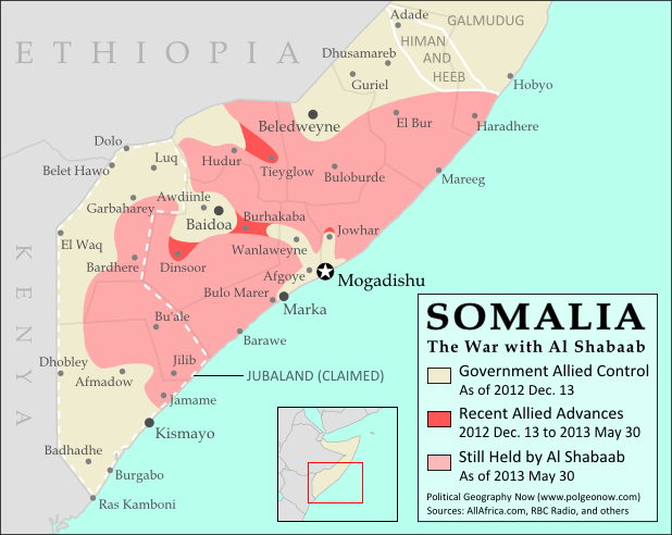
This is the first in our new series of Somalia control maps, which includes regular updates for members of our conflict map subscription service

There are newer version of this map available. To see them, view all Somalia articles on PolGeoNow.

Who controls Somalia? Map (2017). With states, regions, and territorial control. Best Somalia control map online, thoroughly researched and detailed but concise. Shows territorial control by Federal Government of Somalia (FGS), Al Shabaab, so-called Islamic State (ISIS/ISIL), separatist Somaliland, and autonomous states Puntland, Galmudug, Khatumo, and the ASWJ Sufi militia. Updated to of August 25, 2017. Colorblind accessible.
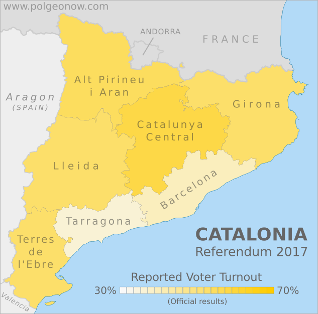
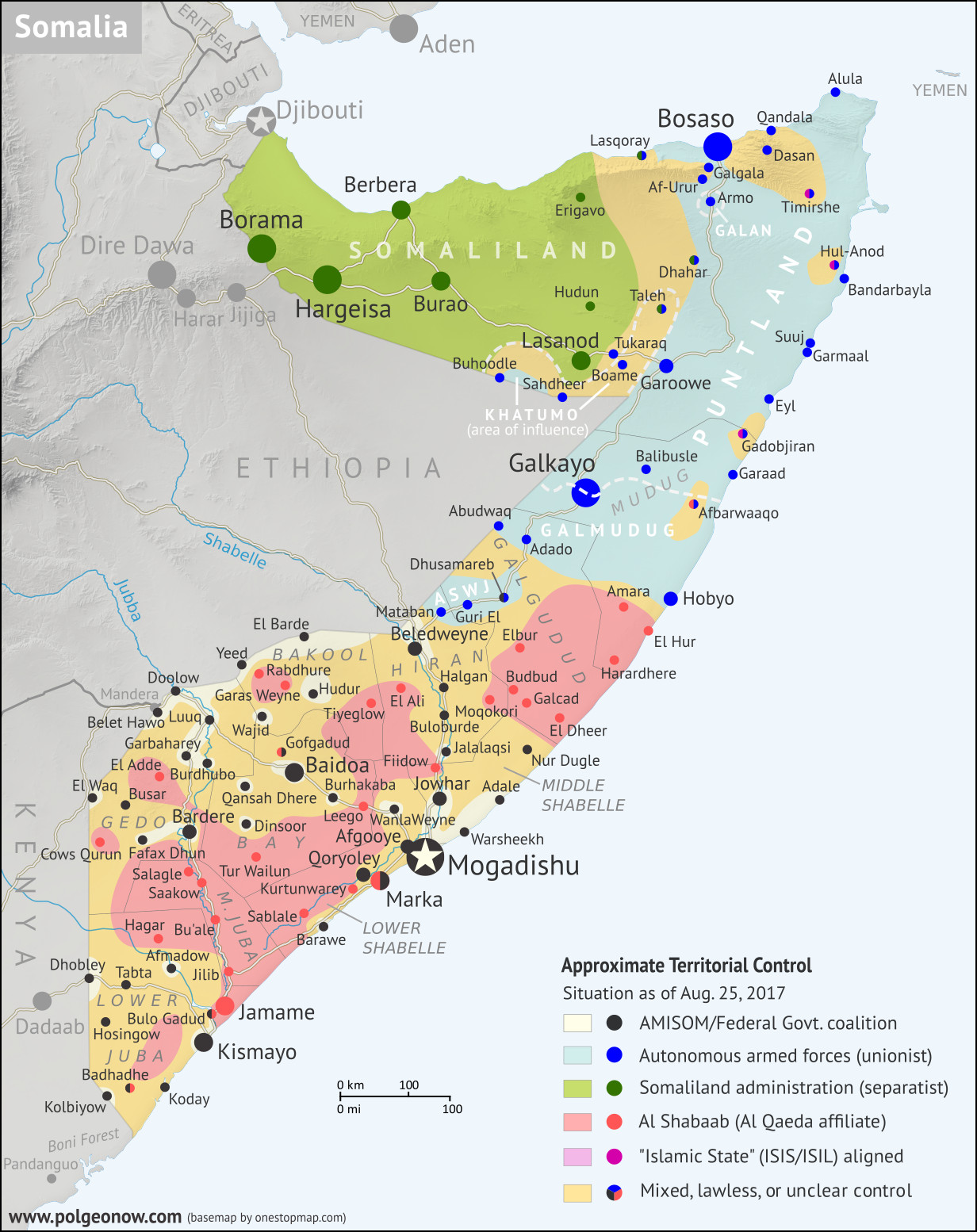
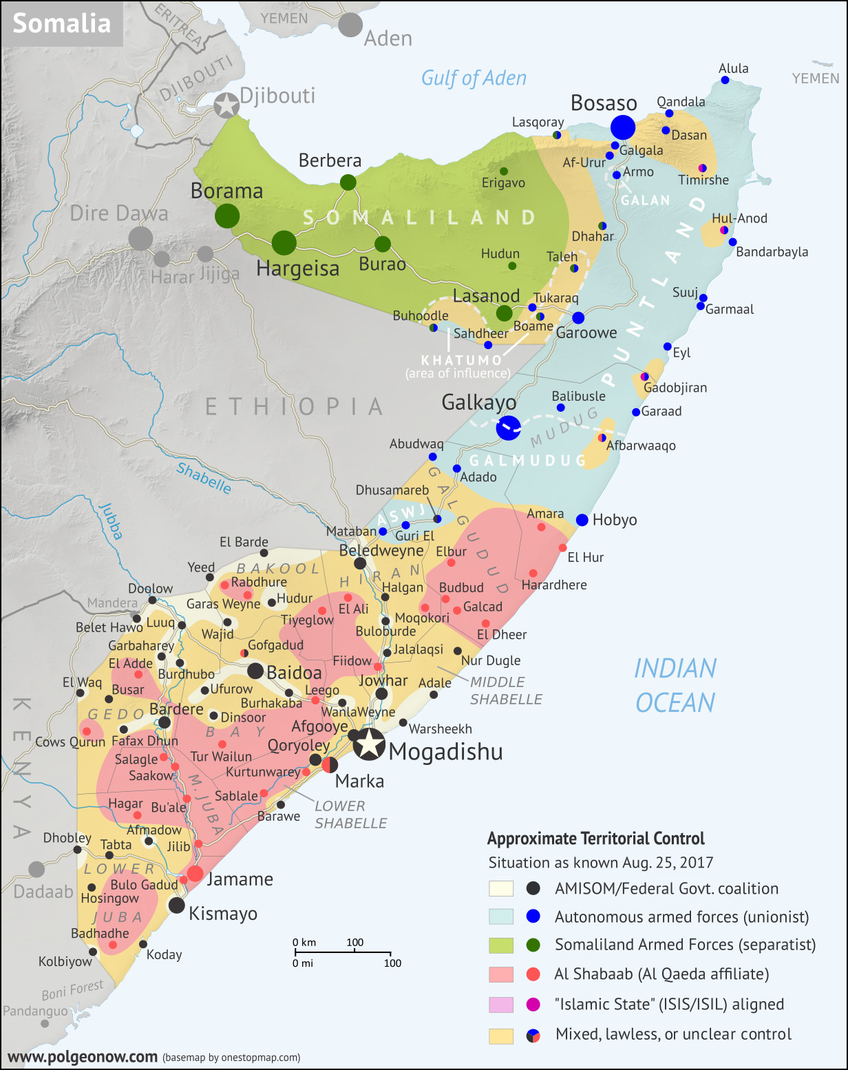
Base map by Koen Adams of onestopmap.com, with territorial control by Djordje Djukic and Evan Centanni. (This graphic has been slightly revised based on newer information. You can see the original version here.)
Contact us for permission to use this map.

(Subscribers click here to view this article in the member area)

Timeline by Djordje Djukic, with additional reporting by Evan Centanni

Mapping Somalia: Who Controls What?

Of all the world’s countries, Somalia is probably the most complex in terms of actual territorial control, and also one of the most constantly-changing. Despite that, good control maps for Somalia are hard to find, with major news outlets using simple, hastily-drawn maps (if any), while crowdsourced mapping projects on sites like Wikipedia suffer from a lack of contributors, infrequent updates, and unclear methods. That’s why Political Geography Now set out to create the best-designed, most thoroughly-researched Somalia control map online.

This map, which will be regularly updated for members of our conflict map subscription service, has been more than half a year in the making, with careful effort put into balancing detail with clear and concise design. For towns shown on the map, the timeline below links to sources for almost all control changes since the end of our previous Somalia map series in 2013.

Behind the scenes, we’re also tracking numerous smaller towns, villages, and rural areas, and using this information to illustrate areas of control on the map. Details and hints on control outside major towns (and even on real situations in the cities) have been painstakingly scoured from various local newspapers, government-researched reports, aid organization documents, and the amazingly-detailed ACLED conflict database.

Flag of SomaliaCountry Name:  
• Somalia (English)
• Soomaaliya (Somali)
• aṣ-Ṣūmāl (Arabic)
Official Name:  
• Federal Republic of Somalia (English)
• Jamhuuriyadda Federaalka Soomaaliya (Somali)
• Jumhūriyyat aṣ-Ṣūmāl al-Fideraaliya (Arabic)
Capital: Mogadishu

Why So Little Government Control?

Forces serving the Federal Government of Somalia – mainly the African Union Mission in Somalia (AMISOM) and the less-powerful Somali National Army – now control most of the major towns and cities in south and central Somalia. Pro-government press releases, and some third-party maps, often extend this to imply that the federal government controls most of Somalia’s south.

However, candid assessments from people on the ground, supported by detailed analysis of local journalism, consistently tell a different story: that the Al Qaeda-affiliated Al Shabaab rebels have free rein right up to the outskirts of major cities, and still rule supreme over many remote villages.

Labeling all these sparsely-populated rural areas as “Al Shabaab controlled” might be an exaggeration, since the group likely doesn’t actively patrol or administer every one of them, and is unlikely to stand its ground when well-armed pro-government forces pass through.

But the pro-government alliance clearly isn’t asserting control there either, so we’ve concluded that “mixed, lawless, or unclear control” (golden yellow on the map) is the most accurate way to label these areas. In more isolated areas where pro-government forces dare tread only as part of a major military offensive, Al Shabaab might be considered more properly in control, and we’ve marked these in red according to our best estimates.

Similar areas of mixed control exist between autonomous administrations in northern and central Somalia, and in turn between them and pockets of Al Shabaab and “Islamic State” (IS) activity. Uncertainty also plays a role, with even some larger towns switching hands frequently, or news media failing to report on smaller territorial changes. We believe that being honest about uncertainty increases the quality of our mapping, so we’ve chosen to apply the yellow shading in any area that we don’t have substantial reason to believe is truly administered or secured by a particular group.

Mogadishu and Marka: Government or Al Shabaab?

Two large cities are of particular note: In Mogadishu, the national capital, Al Shabaab regularly proves that it’s able to easily infiltrate the city and launch devastating attacks. But because the city has a mostly-unopposed civilian administration run by the Federal Government of Somalia, and because pro-government forces are clearly the dominant military force, we’ve still marked it on the map as government-controlled (black).

Meanwhile, the southern port city of Marka (Merca) is also usually claimed as a government-controlled town. An AMISOM contingent is stationed on the outskirts and makes shows of force within the city center, often after well-publicized (alleged) takeovers by Al Shabaab. However, a December 2016 Danish government report – based on interviews with the leader of a humanitarian organization in Somalia and other local sources – concluded that control of the city was in fact “disputed and uncertain”, even describing it as “a mix between Al Shabaab control and a vacuum of power.” We believe this situation justifies marking it with mixed/unclear control on the map.

Timeline of Events in Somalia (2013-2017)

Map of Al Shabaab control in southern Somalia in May 2013, highlighting advances by government and African Union troops since December 2012. Also marks claimed territory of Jubaland state.
Free map: Al Shabaab control in May 2013

The following is a timeline of of major political events, changes to territorial control, and mass violence in Somalia since the last installment of our previous Somalia control map series on May 30, 2013. Sources are provided as in-line links.

June 17, 2013
Somali government and African Union Mission in Somalia (AMISOM) troops captured four towns in Qoryoley district and one other of the Lower Shabelle region, plus El Ali and three other villages near Beledweyne, from Al Shabaab.

June 19, 2013
Al Shabaab fighters attacked a UN office in Mogadishu, leaving at least 15 people dead, including four foreign and four local security workers plus seven of the group’s own fighters. Two of the foreigners worked for South African state weapons firm Denel, while the UK was looking into reports that three British nationals had died.

June 20, 2013
Infighting broke out between two factions of Al Shabaab, one led by top leader Ahmed Godane and the other by American-born Abu Mansoor Al-Amriki.

June 28-30, 2013
Al Shabaab’s spiritual leader, Sheik Hassan Dahir Aweys, left Al Shabaab territory after the infighting and sought refuge, along with his militia, in the Galmudug area. Two days later, he was arrested in Mogadishu by security forces as he flew in for negotiations with government officials. Meanwhile, two days of fighting between rival militias in Kismayo left at least 71 civilians dead and over 300 injured.

July 4, 2013
The warlord Colonel Barre Adan Shire stated he would retake Kismayo after his forces had been pushed out of the city by a militia supported by Kenyan troops the previous month.

July 23, 2013
Ethiopia announced it was withdrawing its forces from Baidoa, handing control of the major city to AMISOM.

August 5, 2013
The self-declared autonomous Puntland state announced it was cutting ties with the Federal Government of Somalia in Mogadishu, citing disagreements over power-sharing.

August 27, 2013
In a bid to end clashes between rival militias in Kismayo and surrounding regions, the Mogadishu government and a Kenya-backed militia signed a deal to create an autonomous “Interim Jubba Administration” in the country’s southwest. This federally-sanctioned government would replace the militia’s unilaterally-declared “Jubaland State” (however, “Jubaland” would continue to be used as an informal name for the Interim Jubba Administration).

September 12, 2013
Abu Mansoor Al-Amriki was killed in the Bay region when a large group of Al Shabaab fighters attacked his smaller group. A Briton was also killed in the infighting, while an Egyptian from Al-Amriki’s group was captured.

September 21-24, 2013
Al Shabaab fighters conducted an attack on the Westgate Shopping Mall in Kenya’s capital city of Nairobi. A four-day siege ensued during which the four attackers killed 67 people, including 19 foreigners. All of the attackers also died. Four of the foreigners were British.

January 1, 2014
Hundreds of Ethiopian troops arrived in Baidoa, the capital of Bay region, establishing new military bases in preparation for operations against Al Shabaab. Ethiopian troops already in Somalia were set to join AMISOM in 2014. Meanwhile three bombs, one possibly a suicide bombing, targeted the Jazira hotel in Mogadishu, leaving 11 people dead and 17 wounded.

January 10, 2014
A small team of US military advisors were confirmed to be present in Somalia for the first time since the US military ended its previous deployment in the country in 1993. The 1993 withdrawal came in the wake of the infamous “Black Hawk Down” incident, when 18 US soldiers were killed after the downing of two military helicopters amid heavy street fighting between US forces and a Somali militia.

January 22, 2014
Some 4,395 Ethiopian soldiers in Somalia were formally integrated into AMISOM.

February 3, 2014
An isolated pocket of Al Shabaab-loyal fighters attacked the town of Galgala in Puntland after being targeted by Puntland security forces in the surrounding areas.

February 7, 2014
Government forces destroyed an Al Shabaab outpost in a town 50 kilometers north of Afmadow, in the country’s southwest.

February 21, 2014
Al Shabaab fighters attacked Villa Somalia, the official residential palace and main workplace of the President of Somalia in Mogadishu. Fourteen people were killed in the attack, including nine Al Shabaab members and five soldiers or officials. One of the dead was General Nur Shirbow.

March 5-9, 2014
Ethiopian troops from AMISOM seized the town of Rabdhure, in the Bakool region, from Al Shabaab. Two days later, Somali and Ethiopian forces captured the town of Hudur, the provincial capital of the Bakool region. They also took control of nearby Wajid district on March 9, as well as Burdhubo district in the neighboring Gedo region.

March 6, 2013
The Jubaland administration denounced the proposed inclusion of its three regions – Gedo, Middle Juba, and Lower Juba – into a new autonomous “South West State” alongside Bay, Bakool, and Lower Shabelle regions. The idea to include the three regions in the new state, leading to armed confrontations between factions supporting and opposing it, would eventually be dropped, after being rejected by both the Somalia’s federal government and the UN.

March 13, 2014
Government and AMISOM troops captured the town of Buloburde, in the central Somalia’s Hiran region, as well as a town 90 kilometers from Beledweyne. Several other towns in the Bay and Bakool regions were also confirmed captured.

March 16, 2014
Somali and AMISOM forces captured the coastal town of Warsheekh, 90 kilometers northwest of Mogadishu in the Middle Shabelle region.

March 18, 2014
A car bomb exploded at a hotel in Buloburde where AU and Somali officers were staying. This was followed by five hours of gunfire. Twelve soldiers were killed and 20 wounded in the attack.

March 22, 2014
Somali and AMISOM forces seized the town of Qoryoley in the Lower Shabelle region.

March 25-29, 2014
Somali and AMISOM forces captured Elbur (Ceelbuur) town in the Galgudud region and Moqokori in the Hiran region from Al Shabaab.

April 15-18, 2014
Forces of breakaway Somaliland seized the town of Taleh, where representatives of self-declared Khatumo state were holding a government meeting, before withdrawing three days later. The town would still to be contested between Somaliland, Khatumo, and Puntland after a year.

May 9, 2014
Somalia’s President Hassan Sheikh Mohamud declared that the first stage of the campaign to seize all areas of the country from Al Shabaab had been completed, with three million people and nine large towns coming under government control, although the campaign had not met all of its targets. He also accused Al Shabaab of trying to create food shortages and turn locals against the state in the government-captured areas.

May 31-June 5, 2014
Somali and AMISOM forces reported they had captured more than half a dozen villages in the Hiran and Bakool regions, including two on the road between Beledweyne and Buloburde, as well as Garas Weyne and Rabdhure near the Ethiopian border (Rabdhure had already been reported captured three months earlier).

June 23, 2014
Two rival administrations of the proposed South West State reportedly signed a deal to merge and create the federally-supported Interim South West Administration (ISWA), dropping claims to the Gedo, Middle Juba, and Lower Juba regions disputed by Jubaland State. However, the leader of the faction advocating the inclusion of the Jubaland regions soon denied having been represented at the meeting, and disagreements between the factions would remain for months.

June 26, 2014
It was confirmed Buloburde had been under an Al Shabaab siege ever since government forces captured it in March. Due to all roads leading to the town being blocked by the group’s fighters, the only means of resupply was by air.

July 30-31, 2014
The Federal Government of Somalia officially approved the formation of a new federal “Central Regions State”, which would merge the self-declared Regional State of Galmudug with the Administration of Himan and Heeb (another self-declared state, centered on Adado town) and Ahlu Sunna Waljama’a (ASWJ), an anti-Shabaab religious militia controlling some towns in the region.

The next day, the government of neighboring Puntland state announced it was withdrawing its support of the federal government in protest of the decision, which it called “unconstitutional”. A major concern was that the new state’s mandate to administer Galgudud and Mudug regions would include Puntland-controlled parts of northern Mudug.

It was unclear whether Puntland had ever actually restored ties with the Mogadishu government since suspending them in August 2013.

August 6, 2014
The administration of Himan and Heeb formally signed on to become part of the new Central Regions State announced a week earlier.

August 8 – October 1, 2014
The autonomous state of Puntland fought an ultimately-successful two-month campaign to expel an Al Shabaab-loyal militia from strongholds in the mountains around Galgala.

August 16-October 28, 2014
A new Somali-AMISOM offensive was launched in the central regions of Somalia, code-named Operation Indian Ocean. Among areas captured by October 28 were Barawe in Lower Shabelle, Tieyglow in Bakool, and Adale in Middle Shabelle, as well as numerous other villages. In addition, the pro-government forces took control of Koday, south of Kismayo, one of the last remaining natural seaports controlled by Al Shabaab, as well as a nearby inland town.

August 27, 2014
The former warlord Colonel Barre Adan Shire agreed to join the ongoing Jubaland peace process. His militia had been pushed out of Kismayo by forces loyal to the President of Jubaland administration Sheikh Ahmed Mohamed Islam.

September 1, 2014
A US drone strike killed the leader of Al Shabaab, Ahmed Abdi Godane.

September 30, 2014
Puntland military reinforcements arrived to Dhahar in the disputed area between Somaliland and Puntland, after clashing with Somaliland-loyal militias five days before.

October 14, 2014
Puntland state agreed to restore relations with the Federal Government of Somalia after three days of negotiations with international diplomats in attendance. The two sides agreed to a new framework for moving forward with federalism, and the federal government in Mogadishu agreed that the newly-approved “Central Regions State” would not include any areas of Mudug region currently controlled by Puntland.

November 7, 2014
The new South West State was officially established with federal support, to include the Bay, Bakool, and Lower Shabelle regions. Barawe was chosen as its official capital.

December 15, 2014
Federal government troops in Galgudud region seized Guri El town from the Sufa group, an ASWJ faction opposed to joining the Central Regions State. The group had gradually taken control of the town over the past month.

December 17, 2014
After more power-sharing talks, the leader of the rival South West administration that claimed six regions – Bay, Bakool, Lower Shabelle, Lower Juba, Middle Juba, and Gedo – agreed to join the federally-approved three-region Interim South West Administration (ISWA), which considers the latter three regions to be part of neighboring Jubaland State.

October-December 2014
Al Shabaab fighters fleeing defeats in southern Somalia and Puntland reportedly regrouped in the southern part of Galgudud region, tightening their grip on an area they had controlled since 2007.

December 25, 2014
An Al Shabaab attack on an AMISOM base in Mogadishu left 14 people dead, including eight Al Shabaab fighters, five AU peacekeepers, and a foreign contractor.

February 10, 2015
The Sufa faction of the ASWJ militia recaptured Guri El town from government troops who had seized it in December 2014.

February 20, 2015
A car bomb and a suicide attack against the Central Hotel in Mogadishu, frequented by politicians, left between 11 and 25 people dead.

March 6, 2015
The Somali foreign minister and ASWJ signed a temporary peace agreement ending four months of fighting with ASWJ militia forces in Galgudud region. Under the ceasefire, government-affiliated troops would withdraw to Dhusamareb and ASWJ fighters to Guri El.

March 27-28, 2015
Al Shabaab fighters attacked the Makka al-Mukarama hotel in Mogadishu, leading to a siege that ended early the next day. At least 20 people were killed and another 28 wounded. All five attackers were also among the dead, as well as the Somali ambassador to Geneva. Fifty people were rescued by security forces, including the Somali Ambassador to Germany.

April 2, 2015
Al Shabaab fighters attacked the Garissa University College in Garissa, Kenya (southwest of Dadaab), killing 148 people. The siege at the university lasted nearly 15 hours. Four of the attackers also died when they were cornered by security forces and blew themselves up, while a fifth attacker was arrested. It was the worst terrorist attack in Kenya since the US embassy bombing in 1998.

April 14, 2015
Al Shabaab fighters attacked the Ministry of Higher Education and Ministry of Petroleum and Resources building in Mogadishu. The attack also included a suicide bomber. Seventeen people were killed, including 8 civilians, 7 Al Shabaab members, and two soldiers.

April 20, 2015
A suicide bomber attacked a UN vehicle in Garowe, the capital of Puntland state, leaving between 7 and 10 people dead, including four UN staffers.

June 1, 2015
Al Shabaab fighters reportedly took over a village in the Mandera area of Kenya, near the Somalian and Ethiopian borders.

June 2, 2015
Media reported that about 50 people had been killed in days of clashes between local Somali militias and Ethiopian paramilitary fighters along the Somali-Ethiopian border.

June 26, 2015
Al Shabaab fighters attacked and captured an AMISOM military base in Leego, near Mogadishu. Between 50 and 70 Burundian soldiers were killed, while another 20 Burundian soldiers and 40 Somali civilians were missing and feared kidnapped. The base had been manned by about 100 Burundian soldiers total. The attack began with a suicide bombing at the base’s entrance, after which dozens of fighters stormed the facility. As many as 50 bodies were later seen, some decapitated, and most of them in military uniforms. Two days later, Somali and AMISOM troops retook the base.

July 1-3, 2015
Somali government and AMISOM forces withdrew from Qoryoley and a nearby town in the Lower Shabelle region. Two days later, local government and civilian sources confirmed them to be under Al Shabaab control, although AMISOM denied its withdrawal.

April-July 2015
A conference was held in Adado to form a government for the new Central Regions State, which during the course of talks would become known as the Interim Galmudug Administration (“Galmudug” is a combination of the names of the state’s two constituent regions, Galgudud and Mudug, a name also used by the self-declared state previously occupying much of the area). The delegates elected a parliament, president, and vice president, and adopted a state constitution that allegedly claimed jurisdiction over the entire Mudug region, despite federal government promises to recognize neighboring Puntland state’s authority over the region’s north. The constitution was reportedly revised on July 29 to withdraw any claims over northern Mudug.

As part of the process of merging into the new Galmudug state, the outgoing Himan and Heeb administration handed over command of its military forces to Somalia’s federal police in Adado. The ASWJ militia, on the other hand, withdrew from the conference in protest of an alleged lack of representation, despite the federal government’s efforts to appease the group by declaring Dhusamareb the capital of Galmudug state instead of Adado.

Just before the previously pro-Galmudug leadership of ASWJ withdrew from the conference, the group’s anti-Galmudug Sufa faction had seized the city of Dhusamareb from pro-federal forces in a surprise attack.

July 19-23, 2015
Somali and AMISOM forces launched “Operation Jubba Corridor”, taking over strings of small towns from Al Shabaab west of Bardere in Gedo region and south and west of Baidoa in Bay region. The operation culminated in the capture of two major towns, Bardere in Gedo and Dinsoor in Bay, along with three areas near Hudur, including Garas Weyne.

July 26, 2015
A suicide car bomber attacked the Jazeera Palace Hotel in Mogadishu, which hosts diplomats and top government officials, leaving 12 people dead.

August 9, 2015
“Regional leaders, politicians, and elders” gathered in Jowhar signed an agreement to form a new federally-approved state from the Hiran and Middle Shabelle regions. The proposed state was initially called “Hiran and Middle Shabelle Regional State”.

August 2015
Some ASWJ factions reportedly chose to rejoin the Interim Galmudug Administration.

September 1, 2015
Al Shabaab fighters attacked and captured another AMISOM military base, this one located near Marka and Qoryoley. The base was quickly recaptured. Between 19 and 21 Ugandan soldiers were officially confirmed killed, between 19 and 27 wounded, and one missing. This was the highest number of Ugandan soldiers killed in a single battle in the war. According to AMISOM sources, between 45 and 100 Al Shabaab fighters were killed and over 60 wounded. Al Shabaab itself claimed between 50 and 70 soldiers had died. The attack came on the one-year anniversary of the death of Al Shabaab’s leader, Ahmed Abdi Godane.

September 7-9, 2015
Galmudug state security forces took over the town of Abudwaq from the ASWJ militia after a two-day battle.

September 17-18, 2015
Al Shabaab fighters again captured the same AMISOM military base they attacked at the beginning of the month after AU forces unexpectedly vacated the base. The next day, the fighters briefly seized a Somali military base farther southwest of Mogadishu, before it was quickly recaptured. Between 9 and 13 soldiers were killed.

October 13, 2015
Galmudug state forces recaptured Amara village in the southern Mudug region from Al Shabaab, after reportedly losing it two weeks earlier. Meanwhile, Somali and AMISOM forces captured a village in the Lower Shabelle region.

October 31, 2015
Al Shabaab fighters stormed the Sahafi Hotel in Mogadishu. Security forces managed to retake the building after fierce fighting. At least 15 people were killed, including at least one member of parliament and the general who led the 2011 offensive that drove Al Shabaab out of Mogadishu. The attack also involved two car bombs.

October-December 2015
Al Shabaab faced a political crisis as, under pressure to switch its allegiance from Al Qaeda to the so-called “Islamic State” (IS; formerly ISIS/ISIL), some of its fighters defied their leaders to join IS. The group’s Al Qaeda-loyal leadership in southwestern Somalia cracked down harshly on pro-IS fighters, while in the mountains of Puntland, discussions led to powerful leader Abdulkadir Mumin pledging allegiance to IS. Fighters operating inside of Kenya were reportedly also divided, with northern groups operating around Mandera switching allegiance to IS, while groups operating in the southern Boni Forest area remained loyal to Al Qaeda.

Free map: “Islamic State” (IS) control in Syria in early 2016

Meanwhile, fighting repeatedly flared up in Galkayo between two autonomous states: Puntland, which controls the northern part of the city, and Galmudug, which controls the southern part. And Kenya, hoping to stop cross-border attacks by Al Shabaab, announced it had begun constructing a 700 km wall along the border with Somalia.

November 13, 2015
Al Shabaab took over Fiidow town, north of Mogadishu, after AMISOM troops vacated the area.

November 26, 2015
A former unit of Al Shabaab now loyal to IS reportedly clashed with Puntland security forces in the mountains around Galgala.

November 30, 2015
Local reports said Al Shabaab fighters seized control of another village inside Kenya.

December 9-11, 2015
An Islamic State (IS) affiliated faction of fighters captured a village in Lower Jubba, about 12 km from Dhobley near the Kenyan border. Jubaland security forces recaptured the village two days later.

December 24, 2015
Al Qaeda-loyal Al Shabaab factions clashed with pro-IS followers of Abdulkadir Mumin in Timirshe village of Puntland state. Afterwards, Mumin’s group reportedly retreated to the former pirate town of Hul-Anod.

December 25, 2015
Three districts along the Ethiopian border of Bakool region declared they were leaving South West state to form a new “Upper Bakool” state. The president of Puntland announced support for the breakaway administration, and after two weeks reconciliation talks were announced between Upper Bakool and the administration of South West State. However, the Upper Bakool project, with its official capital in El Barde, was apparently still moving forward as of several months later.

January 15, 2016
Some 300 Al Shabaab fighters attacked and captured an AMISOM military base at El Adde, in southwestern Somalia’s Gedo region. The attack was swift and began with a suicide truck bombing at the gate, followed by an assault by hundreds of fighters. Many soldiers were killed while they were still sleeping. It marked a potential turning point for Al Shabaab. Between 141 and 150 Kenyan soldiers were killed in the attack, while 11 more were captured, out of 200 soldiers stationed at the base. The base’s commander was also among the dead. Twelve civilians also died. The battle was described as a “tactical disaster” for Kenya and the worst military defeat in Kenya’s history. Due to this, the Kenyan military went to extreme lengths to conceal the extent of its losses and not provide any official casualty figures. All of the figures came from either the United Nations or investigative journalists. The base was recaptured five days later, while the Al Shabaab commander who organized the attack would die in an airstrike on January 21.

January 15, 2016
Military forces of Somaliland attacked a base operated by Khatumo state forces in the town of Sahdheer. The result of the battle was unclear.

January 21, 2016
Al Shabaab fighters attacked a seaside restaurant in Mogadishu, after which a siege ensued that ended in the death of more than 20 people.

January 26, 2016
Kenyan forces withdrew from their bases at Badhadhe and El Adde. Both were subsequently captured by Al Shabaab.

February 2, 2016
A suicide bomber blew himself up on a passenger plane as it set off from Mogadishu. The explosion left a hole in one side of the airliner, but there were no other fatalities and the plane returned to the airport.

February 5-8, 2016
Al Shabaab fighters reportedly occupied the major port city of Marka (Merca) after AMISOM forces “re-adjusted their positions”. However, the peacekeeping force claimed it was still in control of the city. Three days later, reports said government and AMISOM forces had resumed control of the city without resistance.

February 26, 2016
Al Shabaab fighters attacked the SYL hotel and a public garden in Mogadishu, leaving at least 10 people dead and 25 wounded. Four attackers also died.

February 28, 2016
Two suicide bombers in Baidoa killed at least 30 people and wounded 40. The targets were a busy junction and a nearby restaurant.

March 2, 2016
The ASWJ militia retained control of Dhusamareb town after fighting with what one news outlet described as a “renegade general” of the federal government’s army.

March 14-24, 2016
Apparent Al Shabab fighters overran the coastal town of Garaad (Garacad) in Puntland state after reportedly setting off from Harardhere, but they had withdrawn by the next day. Fighters also were reported landing farther north at Garmaal village, as well as in Gadobjiran and Bandarbayla. Puntland security forces reportedly confronted and defeated the fighters in several days of clashes around Suuj, with confrontations and rumored negotiations also reported from Gadobjiran and Bandarbayla.

It was widely suspected that the fighters landing along the Puntland coast were Al Shabaab defectors attempting to join Abdulkadir Mumin’s “Islamic State” (IS) unit in Hul-Anod, possibly even staging an intentional distraction for Puntland’s security forces as the faction’s leaders traveled directly to that town.

By March 24th, Puntland forces claimed to have killed 167 Al Shabaab fighters and captured 100 in fighting around Suuj and Garaad, while Galmudug state forces said they apprehended fleeing fighters in the Hobyo and Galkayo areas.

March 23, 2016
Al Shabaab reportedly captured Afbarwaaqo village in Galmudug state.

April 29, 2016
Somali and AMISOM troops based in Budbud captured the nearby Galcad area from Al Shabaab.

April 30, 2016
Somali and AMISOM forces seized Nur Dugle and two other locations in Middle Shabelle region from Al Shabaab.

May 2, 2016
Human Rights Watch reported that the ASWJ militia was still in control of both Dhusamareb and Guri El. Dhusamareb is also home to an AMISOM base staffed by Ethiopian soldiers.

June 1-2, 2016
Al Shabaab fighters stormed the Ambassador Hotel in Mogadishu, leaving at least 13 people dead and 40 wounded. Three attackers were also killed. Two Somali lawmakers were among the dead.

June 23, 2016
Abdismad Mohamed Galan, the fired former mayor of Bosaso, Puntland state’s largest city, reportedly formed an armed rebel group with the goal of deposing the state’s president. Galan’s group then occupied Armo and other towns along the main road between Bosaso and the state capital of Garowe. Galan would apparently still be in control of Armo a year later, despite Puntland’s attempts at using both force and diplomacy to dislodge his forces.

June 25, 2016
Al Shabaab fighters, including a suicide bomber, stormed the Naso Hablod hotel in Mogadishu, leaving at least 15 people dead and 25 wounded.

July 11, 2016
For the second time in six months, Al Shabaab captured the port city of Marka after government and AMISOM troops withdrew. Several hours earlier, Al Shabaab temporarily overran a Somali government military base 40 km west of Mogadishu.

July 17-18, 2016
Al Shabaab briefly captured Qoryoley, near Marka, before it was retaken by Somali and AMISOM forces the following morning.

July 18, 2016
AMISOM reasserted control of Marka. Meanwhile, in the north, a Puntland-aligned former pirate leader clashed with the military of breakaway Somaliland in the town of Dhahar.

August 7, 2016
Somalia delayed its presidential election from August to the end of October.

August 11, 2016
Over 200 soldiers of the self-declared Khatumo state reportedly surrendered to the Somaliland military at a location 54 km from Buhoodle, as Khatumo’s leader announced peace talks between the two administrations.

August 15, 2016
Somali and AMISOM forces in Gedo region captured four areas south of Bardere from Al Shabaab.

September 16, 2016
Al Shabaab seized the town of El Waq near the Kenyan border, before it was recaptured by Somali forces by the end of the day.

September 27, 2016
The US government said an airstrike it conducted in the Galmudug area left nine Al Shabaab fighters dead, while according to the Somali government 22 civilians and soldiers were killed instead. The Galmudug state government accused rival Puntland of tricking the US military into striking its territory, and Al Shabaab denied having any personnel in the area.

=Meanwhile, Somalia’s presidential election was again delayed from October to November, while parliamentary elections were delayed until October 23.

October 7, 2016
As of early October, Al Shabaab forces in southern Somalia were still in control of the towns of Jilib (described as their “capital”), Jamame, Bu’ale, Saakow, Badhadhe, Hagar, and Salagle.

October 17, 2016
Government forces recaptured a town on the road from Afgooye to Marka after it was briefly taken over by Al Shabaab.

October 17, 2016
Lengthy negotiations to form the Hiran and Shabelle federal state, which came to be known as “Hirshabelle”, concluded with the election of a president and vice president for the state’s interim administration, based in Jowhar. Meanwhile, an opposing political group was preparing to form a separate “Hiran State” with its capital in Buloburde.

October 18, 2016
Al Shabaab fighters attacked a police station and several military bases in Afgooye, leaving 10 soldiers and civilians dead. The fighters eventually withdrew and government forces secured the town.

October 26, 2016

Free map: “Islamic State” (IS) control in Iraq, September 2016

Abdulkadir Mumin’s IS-loyal fighters captured the port town of Qandala in Puntland.

Meanwhile, Al Shabaab captured the town of Tieyglow in Bakool region after non-AMISOM Ethiopian forces withdrew citing “lack of support” from the international community. This reportedly brought the number of areas seized by Al Shabaab following the July 2016 withdrawals by international forces to eight. The other areas retaken by Al Shabaab were Rabdhure, Garas Weyne, and a town between Rabdhure and Wajid in the Bakool region; Budbud and Galcad in the Galgudud region; and Moqokori, El Ali, and Halgan in the Hiran region.

November 7, 2016
Four of the six federal states of Somalia completed their election of members for the new upper house of the Somali Federal Parliament. However, the elections for the more important lower house, which were supposed to take place between October 23 and November 10, had still not begun.

November 12, 2016
The autonomous Puntland and Galmudug states agreed on a ceasefire to end clashes in the divided city of Galkayo, after talks mediated by the Somali federal government and attended by UN, European Union, and African Union representatives. However, fighting would continue to flare up into December.

November 22, 2016
Al Shabaab fighters reportedly attacked a village on the outskirts of Garissa, Kenya (southwest of Dadaab).

November 24, 2016
Elections for the lower house of the Somali Federal Parliament reached the halfway mark.

November 26, 2016
A car bomb exploded at a market in Mogadishu, killing at least 20 people.

November 30, 2016
Somalia’s presidential election, which was supposed to take place on November 30, was delayed for a third time to the following month.

December 2, 2016
The Kenyan government announced that its stalled Somali border wall project had resumed construction, with three kilometers of a planned 30 km fence completed near Mandera.

December 7, 2016
Puntland forces recaptured Qandala port from IS.

December 11, 2016
A suicide bomber attacked Mogadishu’s port, Somalia’s biggest, killing at least 29 people.

December 18, 2016
Somali officials accused AMISOM peacekeepers of killing 11 civilians in two separate incidents, one of which left a mother, three children and a baby dead.

Meanwhile, Puntland security forces drove IS-loyal fighters out of a town 30 km south of Qandala, where they had been staging a new military build-up after withdrawing from Qandala itself.

December 27, 2016
A new Somali parliament was inaugurated, an accomplishment welcomed by the Secretary-General of the United Nations. The country’s presidential election, on the other hand, was again delayed until January.

December 28, 2016
Al Shabaab once again reportedly captured Moqokori town in the Hiran region without resistance after Somali and AMISOM forces abandoned it. Reporting in October had already listed the town as one of those retaken by Al Shabaab after widespread withdrawals of government-allied forces.

January 8, 2017
Al Shabaab recaptured the Bulo Gadud district, near Kismayo, after losing several villages in the area the previous week.

January 23-24, 2017
Al Shabaab temporarily captured large parts of the town of Afgooye, near Mogadishu, before its attack was repelled. The next day, a bomb planted by the group exploded at a base on the southern side of Afgooye, killing seven policemen.

January 24, 2017
Jubaland forces, supported by AMISOM, captured the Al Shabaab stronghold of Badhadhe in the Lower Jubba region. However, within hours, Al Shabaab had retaken the town.

January 25, 2017
Al Shabaab fighters attacked the Dayah Hotel in Mogadishu, leaving 28 people dead and either 43 or 51 wounded.

January 27, 2017
Al Shabaab attacked a Kenyan military base at Kolbiyow on the Somali-Kenyan border. During the ensuing fighting, the group claimed at least 66 Kenyan soldiers were killed. The Kenyan military denied this, instead saying that 9 soldiers and 2 Kenyan policemen were killed, while also claiming that more than 70 Al Shabaab fighters died. Al Shabaab additionally claimed it had overrun the base and taken control of the surrounding area, which the Kenyan military also denied.

February 5, 2017
Two Kenyan families who had lost their relatives in the attack on the Kolbiyow military base the previous month urged their government to withdraw its military from Somalia. The latest reports put the Kenyan military death toll from the base attack at 21.

February 8, 2017
Fighters loyal to IS attacked a hotel in Bosaso city of Puntland state.

February 9, 2017
Mohamed Abdullahi Farmajo was chosen as president by Somalia’s MPs in a vote held in an aircraft hangar at the heavily guarded Mogadishu airport.

February 11, 2017
It was announced that the pro-government ASWJ militia would be integrated into the Somali National Army “soon after the elections”, due to the group’s good relations with newly-elected President Farmajo.

Free map: “Houthi” and Al Qaeda control in Yemen, December 2016

February 13, 2017
The breakaway region of Somaliland agreed to allow the United Arab Emirates (UAE) to build a military base in the port town of Berbera. The base would be used to fight forces of the unrecognized “Houthi” government in Yemen.

February 19, 2017
A suicide car bombing at a market in Mogadishu killed 39 people and wounded around 50.

February 21-23, 2017
Al Shabaab captured two towns from Galmudug state forces in the southern part of the Mudug region: El Hur on the coast and Amara farther inland.

February 26, 2017
Dozens of soldiers in the autonomous state of Puntland briefly staged a mutiny by seizing the parliament compound in the state capital of Garowe, but withdrew to their barracks after a request by one of the region’s most respected clan elders. The soldiers were protesting delayed payment of their salaries as well as poor working conditions.

February 27, 2017
Somalia’s president requested that Saudi Arabia persuade the UAE not to build a military base in Somaliland.

March 2, 2017
In one of the deadliest assaults on Al Shabaab, AMISOM and Somali forces attacked one of the group’s camps 31 km northwest of Afmadow, killing at least 57 Al Shabaab members.

March 11, 2017
Al Shabaab briefly captured a military base eight kilometers southwest of Mogadishu, before its fighters were pushed back in fighting that left four dead on both sides.

March 13, 2017
Two suicide bombing attacks killed nine people in Mogadishu near a hotel and a military base.

Meanwhile, after five years without any major piracy incidents of the Somali coast, pirates hijacked an oil tanker named Aris 13 and anchored it in the town of Alula. The eight Sri Lankan crewmembers were also abducted. The ship was carrying fuel from Djibouti to Mogadishu.

March 16, 2017
Pirates released the hijacked oil tanker Aris 13 after being confronted by Puntland security forces and engaging in negotiations.

April 3, 2017
Government-allied Ethiopian troops abandoned Elbur town in the Galgudud region, with Al Shabaab taking control of it soon after.

April 10, 2017
A suicide car-bombing in Mogadishu left 15 people dead. The target of the attack was Somalia’s new army chief, who survived. The attack was said to be in response to the new president’s declaration of war against Al Shabaab. In the period between April 5 and 7, several other attacks in the capital had together killed 29 people.

April 14, 2017
It was announced that the US would be sending dozens of soldiers to Somalia to provide logistical training to Somalia’s army. This would be the first time the US sends such a large deployment of troops to Somalia since the US military pulled out of the country in 1993 following the disastrous “Black Hawk Down” incident.

April 15-16, 2017
IS-loyal fighters briefly took over Dasan village in Puntland, near Qandala, before withdrawing the next morning.

April 21, 2017
It was reported that 52 Al Shabaab fighters were killed by Kenyan forces in an attack on their camp in the Badhadhe area of Lower Juba. Later reports said more than 100 fighters in Gedo region were killed by US airstrikes in El Adde and an area near El Waq.

April 24, 2017
Al Shabaab withdrew from the town of Halgan, on the road from Beledweyne to Buloburde.

April 25, 2017
Federal government-brokered talks to integrate the ASWJ militia into Galmudug state ended without an agreement.

May 5, 2017
It was reported that a US servicemember was killed in action, and another two wounded, during a raid against Al Shabaab 64 kilometers west of Mogadishu. US forces were said to be conducting an advise-and-assist mission with Somali government troops. The death represented the first time a US servicemember had been killed in combat in Somalia since 1993.

May 9, 2017
Al Shabaab captured the town of Gofgadud, about 30 kilometers north of Baidoa, following clashes that left 17 Somali soldiers dead. The town had apparently been reported taken by Al Shabaab on four separate occasions in 2016, often after underpaid troops vacated the area. However, some of the reports may refer instead to another village, Gofgadud Shabelow, about 25km southwest of Baidoa.

May 27, 2017
AMISOM and Somali government forces reportedly moved back into Gofgadud.

June 8, 2017
Al Shabaab overran the Af-towns Urur army base in the Puntland region, killing up to 70 people, including both soldiers and civilians, while at least 40 soldiers were wounded. The organization claimed to have captured the base and surrounding town, though the area was apparently back in control of the Puntland government the next week.

June 11, 2017
Targeting Al Shabaab, the United States conducted its first airstrike in Somalia under the Trump administration.

June 14, 2017
The town of Balibusle in Puntland state was attacked by an allegedly Galmudug-affiliated militia.

June 14-15, 2017
An Al Shabaab attack on a popular restaurant in Mogadishu left 31 people dead and nearly 40 wounded. The attack started with a car bombing, followed by an all-night siege in which five attackers posing as soldiers took over the restaurant and held hostages. All of the attackers were eventually killed and a number of hostages were rescued, including foreign citizens.

June 17, 2017
The self-declared states of Khatumo and Somaliland reached a peace agreement, which Somaliland media characterized as a deal for Khatumo to be absorbed into Somaliland. However, the agreement would stall over the following weeks amid reports of opposition from within both the Somaliland government and the Khatumo political establishment.

June 20, 2017
A car bomb attack in Mogadishu killed at least 15 people.

July 5, 2017
Suspected Al Shabaab fighters attacked a police post in Pandanguo, Kenya, with the ensuing battle lasting for at least seven hours. The following week, the Kenyan government was reported to be responding with airstrikes in the neighboring Boni Forest.

July 6, 2017
A joint US-Somali attack on a force of about 100 Al Shabaab fighters near Kismayo left 13 of the fighters dead and 10 wounded.

July 23, 2017
The president of Hirshabelle state announced an initiative to find a new, “sensible name” for the state.

July 30, 2017
Al Shabaab ambushed AMISOM troops in the Lower Shabelle region, with the fighters claiming they had the bodies of 39 soldiers in their possession. The deputy governor of the region said government forces had carried the bodies of 23 AMISOM soldiers and a Somali soldier from the scene of the ambush. Uganda itself claimed only 12 Ugandan soldiers were killed.

August 3, 2017
Somalia’s government announced that Turkey would soon be opening a large “military training camp” in Mogadishu.

August 4, 2017
Al Shabaab captured the town of Leego, 120 kilometers from Mogadishu, after Ugandan AMISOM troops withdrew. The capture of the town effectively cut off Mogadishu from land access to Baidoa and the rest of the the Bay and Bakool regions.

August 19, 2017
AMISOM and Somali government forces captured an Al Shabaab stronghold just west of Afgooye, near Mogadishu. A week later, controversy arose after ten civilians, including three children, were reportedly killed by a US-backed raid on the same town.

August 20, 2017
The Kenyan government ordered residents of the Boni Forest area in Kenya to evacuate ahead of planned heavy airstrikes. Al Shabaab had reportedly killed 20 police officers and 10 local residents in the area over the past two months.

August 23, 2017
Tensions were reportedly high along the road from Adado to Dhusamareb, as Galmudug forces and ASWJ fighters jockeyed for control of the area. 

Stay informed: Sign up for our professional conflict mapping service for regular updates to the Somalia map and timeline!

Graphic of Somali flag is in the public domain (source).

Map: Which Schengen Borders are Closed to Passport-Free Travel in August 2017?

Last year, we explained Europe’s Schengen free travel area in plain English, then published maps of which European countries had temporarily reintroduced border controls as of March 2016, August 2016, and February 2017. Here’s an update and summary for August of 2017.

Schengen borders map showing temporary reintroduction of border controls in the Schengen Area (the European Union's border-free travel zone) as of August 2017, showing internal Schengen borders closed to passport-free travel in the period after the election of French President Emmanual Macron.
Map by Evan Centanni, from blank map by Ssolbergj. License: CC BY-SA

Article by Evan Centanni

Current Border Controls Between Schengen Countries

As anyone who’s visited Europe in recent decades knows, much of the continent is linked together as part of the “Schengen Area“, a collection of countries that don’t make travelers show any ID to cross back and forth across their borders (though this system is overseen by the European Union, the Schengen Area and the EU aren’t the same thing). But the system does allow countries to temporarily reintroduce border controls under certain circumstances.

With the spike in numbers of refugees and other immigrants arriving in Europe in the past two years, many Schengen countries have rushed to control the flow of people by using these special temporary exemptions. When we published our previous map of border controls within Schengen this past February, there were seven member countries reserving the right to perform border checks. Now there’s one fewer, and the remaining six have renewed their declarations – perhaps for the last time.

It’s important to note that the border controls shown on the map above are the maximum allowed under each country’s declaration – actual enforcement may be extensive, limited, or even absent depending on the circumstances.

Learn More: The UK already isn’t part of the Schengen Area or Eurozone, so what will change when it leaves the EU?

The 5 Schengen Countries with Negotiated Border Controls

Map of the European Union (EU) and prospective member countries
The full EU and prospective members

Amid fears that the Schengen Area’s dream of free travel was going down the drain, the foreign ministers of the EU’s member countries met up and hashed out a compromise solution last year, with five countries reducing the scope of their border controls by refocusing them on high-priority areas:

  • Germany agreed to control only its border with Austria, ruling out border controls with Switzerland, the Czech Republic, Luxembourg, Belgium, the Netherlands, and Denmark.
  • Austria agreed to control only its borders with Slovenia and Hungary, ruling out border controls with Italy, Switzerland, Liechtenstein, the Czech Republic, and Slovakia.
  • Denmark agreed to control only its border with Germany (including land crossings and ferry connections), ruling out border control for arrivals from Sweden or Norway.
  • Sweden agreed to control only crossings over the bridge from Denmark and sea arrivals along its western and southern coastline, ruling out controls for land borders with Norway and Finland or arrivals by sea along its east-central and northern coasts.
  • Norway agreed to control only arrivals in ports with ferry connections to Sweden, Denmark, and Germany, ruling out controls along its land borders with Sweden and Finland.

These border controls were extended three more months in November 2016, then another three months in February 2017. Finally, on May 11, the EU government approved one more extension – this time for six months. But this will be the final extension allowed under official Schengen rules: According to the plan, the five affected countries will have to phase out all Schengen-internal border controls by the deadline of November 11, 2017.

In fact, Sweden had already announced just before the extension that it would be ending some border checks for travelers arriving from Denmark; but the announcement said other types of checks would continue, and the country did go ahead and notify the EU that it would accept the extension to November.

France’s Border Controls Extended for the Fifth Time

Unlike most of the countries with temporary border checks, which have focused their controls on specific stretches of borders popular with refugees and other migrants, France has reserved the right to maintain controls on all its borders – except, presumably, the boundary with tiny Monaco, which for immigration control purposes is already treated like part of France.

Unlike other countries with border checks, France’s controls are justified mostly as an anti-terrorism measure, not as a way of keeping out migrants. The French border controls were first declared in 2015 and have been in place ever since then due to several extensions:

Start Date Duration Stated Reason
Nov. 13, 2015* 1 month Paris Climate Change Conference 
Dec. 14, 2015 6 months, 12 days “emergency state as introduced further to Paris attacks
May 27, 2016 2 months Euro 2016 and Tour de France
July 26, 2016 6 months “emergency state as introduced further to Nice attack
Jan. 27, 2017 5 months, 18 days “persistent terrorist threat”
July 16, 2017 3 months, 15 days “persistent terrorist threat”

*France’s November-December 2015 border controls were only for air and land borders (sea ports were excluded)

The most recent extension, posted on the EU’s Schengen website but apparently not reported in the English-language media, expires after October 31. This is probably part of newly elected President Emmanuel Macron’s plans to extend the country’s overall state of emergency, though Macron does say he believes in preserving Schengen’s free-travel principles in the long run. That attitude stands in contrast to his defeated opponent for the presidency, Marine Le Pen, who had promised to suspend all participation in Schengen while also preparing for a vote on leaving the EU.

Temporary Border Controls in Malta, Portugal, Italy, and Germany

At the time of our last Schengen border control map report, the tiny island country of Malta had also declared temporary border checks as a security precaution while the country was hosting two important political summits related to migration into Europe. Those checks lasted for just twenty days, expiring after February 9.

Since then, Portugal also announced temporary border controls, for security during a visit by the Pope (May 10-14), and Italy did the same when hosting a G7 summit (May 10-30). Germany also reserved the right to enforce controls on all its borders – not just with Austria – from May 15 to July 9 while it prepared to host the G20 financial summit.

These truly temporary suspensions of free travel are a normal part of the Schengen system, and all three countries have since let the declared controls expire.

Learn More:
Which Countries Are in the Schengen Area, and Which EU Countries Aren’t? 
Map of Temporary Schengen Border Controls in March 2016 
Map of Temporary Schengen Border Controls in August 2016 
Map of Temporary Schengen Border Controls in February 2017