
There are newer versions of this map available. To see them, view all Syria updates.
Country Name: Syria (English), Sūriyya/Sūryā (Arabic)
Official Name: Syrian Arab Republic (English),
al-Jumhūriyyah al-‘Arabīyah as-Sūriyyah (Arabic)
News Category: Divided Countries
Full Story: See Syria Divided by Armed Conflict
 |
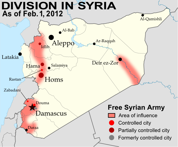
| Known areas of armed activity for the rebel “Free Syrian Army” – many rural areas may be under full rebel control. Unarmed protests not shown. Revised for control of Qalaat al-Madiq and Azaz (see article). Map is my own work, starting from this blank map by German Wikipedia user NordNordWest. License: CC BY-SA |
(Note: For further updates to this map, follow the Syria label on Political Geography Now.)
Syria Conflict Update
The last few weeks have seen territorial losses for the Free Syrian Army (FSA), as government forces have executed a series major offensives on rebel-held areas. By the end of February, Qusayr near Homs was already reportedly only under partial control of the FSA, and on March 1 the Syrian army overran the rebel stronghold district of Baba Amr in the city of Homs itself. While fighting continues in a few other districts, the capture of Baba Amr was widely seen as crucial defeat for the FSA in Homs.
Less than two weeks later, government forces successfully took the northern city of Idlib from the rebels after a three-day battle. Daraa in the south and Deir ez-Zor in the east have also seen government offensives, while shelling continues in Rastan and rebel-held areas of Hama, though territorial control of these areas has mostly not changed. Meanwhile, since our last update, significant FSA activity has been reported for apparently the first time in the areas around Aleppo and Al-Qamishli, both cities that have been relatively quiet up until now.
This map also contains a correction from the last report – the town of Zabadani near Damascus was held by the rebels through late January and early February, but was taken back by the Syrian army prior to the last map update on February 26. That map has now been updated as well. Finally, the meaning of red coloration for cities on the map has been adjusted to include cities mostly under rebel control, since it is often difficult to determine whether control is 100% complete. You can see Political Geography Now’s original report and background information on the Syrian uprising in the article entitled Syria Divided by Armed Conflict.
Revision (April 10, 2012)
Since this map was first posted, it has since been reported that Azaz and Qalaat al-Madiq were already under rebel control on March 20. The map has been revised to show this.
Useful Link: Wikipedia – Timeline of the 2011-2012 Syrian Uprising


