2013: The Year in Political Geography Changes

By Evan Centanni

Premium members click here to view this article in the ad-free members area. Not a member yet? Subscribe now!

 Although popular for maps of territorial control in conflict zones, PolGeoNow’s original mission is tracking formal changes to the world’s political geography. When new countries appear, borders change, and territorial disputes arise or are settled, you’ll hear about it here. As 2013 draws to a close, here’s our look back at the major events of the year:
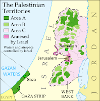
Map of the Palestinian Territories, now known in the official standard as
“State of Palestine”

Country Name Changes
This year didn’t see the creation of any new countries (unless you count the failed bid of the Bangsamoro Republik), but there were a few changes to country names. In October, the African island country of Cape Verde chose to change its official English name to “Cabo Verde”, with the long form being “Republic of Cabo Verde”. This brings it in line with the name in Portuguese, the country’s official language. Meanwhile, in January, Libya established its full name as “State of Libya,” after more than a year of going without an official long-form name. Since the 2011 revolution, the new government had been calling the country anything but Muammar Gaddafi’s preferred “Great Socialist People’s Libyan Arab Jamahiriya”.

This year the international ISO standard for country names also made two updates based on changes that actually happened in 2012: Somalia became “Federal Republic of Somalia” after its Transitional Federal Government was replaced by a permanent one, and “the Occupied Palestinian Territory” became “the State of Palestine” to reflect official U.N. usage after Palestine was upgraded to country status by the organization’s General Assembly.
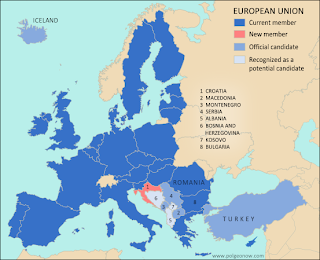
Map of the European Union, new member Croatia, and prospective future member countries
Croatia joins the European Union

See also:
All articles on country name changes 
Is Palestine Really a Country?
Somalia: The Retreat of Al Shabaab

Intergovernmental Organizations
Though the membership roster of the ever-conspicuous United Nations didn’t change this year, and the world’s more obscure intergovernmental organizations are too many to keep up with, there were some changes to the member lists of prominent world bodies. Perhaps most notably, Croatia joined the European Union (and left CEFTA), and both Laos and Tajikistan became members of the World Trade Organization.

Map of the Bolivarian Alliance for the Americas (ALBA), including new member Saint Lucia
Saint Lucia joins ALBA

Also in 2013:

See also:  All intergovernmental organization articles

Map of all countries that recognize the Republic of Kosovo as independent
Countries recognizing Kosovo

Diplomatic Recognition
The world’s partially recognized countries continued to struggle for international validation in 2013. Kosovo proved most active with eight new recognitions, bringing its total to 53% of all U.N. members. Meanwhile, Palestine has the most total recognitions for a country not in the U.N., gaining two and revealing one more in 2013 for a total of 69%. On the other hand, late in the year Taiwan lost recognition from the Gambia, bringing its number of diplomatic allies down to just 22 (11% of U.N. members).

In the messy foreign relations of Western Sahara, Haiti “withdrew” its prior recognition of the disputed state (though there are arguments this is legally invalid), while Barbados, Saint Vincent and the Grenadines, and Panama “froze” their relations. However, Honduras re-initiated its relationship with Western Sahara after allegedly withdrawing recognition in 2000. Meanwhile, South Sudan, the world’s newest country, established diplomatic relations with Benin this year, though since it’s an uncontroversial member of the U.N., all the world’s countries are already assumed  to recognize it by default.

Map of the former territorial dispute between Niger and Burkina Faso, resolved in a 2013 ruling of the International Criminal Court
Border dispute resolved

See also: All articles about diplomatic recognition

Disputed Territories
Many – probably most – of the world’s countries maintain territorial disputes with their neighbors, disagreeing over borders or claiming key regions as their own. But this year saw the resolution of two such disputes, one over the course of the border between Niger and Burkina Faso, and the other over the land surrounding Preah Vihear temple between Thailand and Cambodia.

Meanwhile, small disputes sprung up on the Guinea-Côte d’Ivoire border and between India and Myanmar, though neither has developed into a high-level international spat. Conversely, another new claim was probably all bark and no bite: upset over an existing dispute, Nicaraguan president Daniel Ortega threatened in August to “recover” an entire province of Costa Rica.

Map of the territorial seas and exclusive economic zone (EEZ) of the Falkland/Malvinas Islands disputed between the U.K. and Argentina
Seas of the Falkland Islands

No major disputed territories seem to have traded hands violently this year, but there have been some power shifts nonetheless. Though the dispute was legally resolved years ago, Nigeria only just this summer finished transferring the Bakassi Peninsula to Cameroon’s control. Meanwhile, the northern region of Kosovo, whose local government considers it part of Serbia, saw a change in status as Kosovo agreed to grant it partial autonomy. And in the hotly disputed South China Sea, China consolidated its control over the Filipino-claimed Scarborough Shoal, while also laying siege to another shoal occupied by the Philippines.
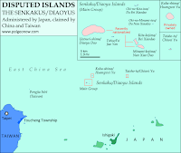
Map of the Senkaku/Diaoyu Islands, disputed between Japan and China
The Senkaku/Diaoyu Islands

However, the two highest-profile disputes this year were probably the Senkaku/Diaoyu Islands in the East China Sea and the Falkland/Malvinas Islands in the South Atlantic, though neither experienced any real change of status. The Senkaku/Diaoyus have been the scene of escalating brinkmanship between China and Japan, while the Falklands incurred the wrath of Argentina when they voted by a margin of 99.8% to remain a U.K. territory. This year PolGeoNow published a map of the Falklands’ disputed seas, a map and feature on the Senkaku/Diaoyus, and a photo-illustrated dossier on the latter group’s eight different islands.

See also: All articles on disputed territories 

Air and Seas
Though neglected by most maps, maritime and airspace claims are very important to modern international relations. No changes to claims of territorial waters and exclusive economic zones (EEZs) came to our attention this year, though Somalia did reassert a claim to extensive territorial waters in contravention of a previous agreement with Kenya, and the U.S. signed a treaty with Kiribati ironing out sea borders in the Pacific. On the other hand, control over resources on the seabed beyond EEZ limits continued to be a hot topic, with Russia, Nicaragua, Micronesia, Denmark, Angola, and Canada all filing full or partial claims with the a U.N. commission this year.

Map of the dispute between North Korea and South Korea over their maritime boundary
Korea’s sea border dispute

Somalia also made news about its airspace in 2013, final taking possession of its own skies from a U.N. caretaker body that had administered them since 1994. Breakaway state Somaliland, however, objected to Somalia’s federal government taking over the entire region’s airspace, asserting control over its own portion and refusing to let federal government aircraft land in the territory. However, the dispute was eventually resolved, with Somalia and Somaliland establishing a joint committee for air traffic control in the region.

See also: All articles on maritime borders and jurisdiction

Happy new year, and keep coming back to PolGeoNow for more changes to geography in 2014!

    South Sudan Crisis: Rebel Control Map (Premium Content)

    There are newer versions of this map available. To see the full list of updates, view all South Sudan articles

    Report and map of rebel control in South Sudan's December 2013 political crisis; includes indications of control by state and city, including Juba, Bor, Bentiu, Malakal, and more

    Download PDF
    buy

    After a sudden outbreak of political violence last week, the military of South Sudan has fragmented into two competing factions, with rebellious defectors capturing a large swath of the world’s newest country. PolGeoNow now presents the first map of rebel control in South Sudan’s ongoing crisis, an exclusive for premium subscribers and purchasers.

    Premium article includes:

    • Exclusive, up-to-date map of rebel control by state and city in South Sudan’s ongoing uprising
    • Outline of the course of events so far, including the captures of three state capitals by rebel forces
    • Brief description of the causes and humanitarian consequences of the current conflict

    Members click here to proceed to article and map

    Not a member yet? Subscribe Now!

    Syria Civil War Map: December 2013 (#12)

    There are newer versions of this map available. To see them, view all Syria updates.

    In addition to updates on the situation, our updated Syria control map now distinguishes the territory of extremist groups ISIS and Al-Nusra from that of Free Syrian Army or mixed rebel coalitions. (To see other maps in this series, view all Syria updates.)

    Tired of waiting months for Syria map updates and briefings? Subscribers to our premium member service will soon begin seeing much more frequent Syria control updates. Don’t miss out – sign up now!

    Map of fighting and territorial control in Syria's Civil War (Free Syrian Army rebels, Kurdish groups, Al-Nusra Front, ISIS/ISIL and others), updated for December 2013. Includes recent locations of conflict and territorial control changes, Al-Safira, Khanaser, Maaloula, Qara, Nabek, and .
    Area of fighting and territorial control in Syria’s civil war, updated for December 2013. Map by Evan Centanni, starting from this blank map by German Wikipedia user NordNordWest. License: CC BY-SA

    Premium members click here to view this article in the ad-free members area. Not a member yet? Subscribe now!

    Al-Nusra and the ISIS
    In addition to updates on the situation since our previous Syria war map, this edition of the map also shows which cities are controlled primarily by religious extremist groups the Al-Nusra Front and the Islamic State of Iraq and Syria (ISIS) (also translated from Arabic as ISIL, the Islamic State of Iraq and the Levant). While these groups share many of their goals with the Free Syrian Army and other rebel groups fighting the Assad government, and in many cases still cooperate strategically with those groups, they are increasingly emerging as a separate bloc in the multi-sided conflict.

    Though most of the rebels in Syria are Sunni Muslims, many of them hope to establish a secular democracy with representation for all Syrians. Al-Nusra and ISIS, on the other hand, base their entire organizations around a violent extremist religious ideology. Both are affiliates of Al Qaeda, and have claimed responsibility for many of the most brutal atrocities committed during the war. Unlike the Free Syrian Army (FSA) and other rebel groups operating in the country, which are apparently made up mostly of native Syrians, Al-Nusra and ISIS include large proportions of foreign fighters. In fact, ISIS is the same group once known as Al-Qaeda in Iraq, and has been part of the insurgency in that country since soon after the Iraq War began in 2003.

    Flag of Syria under the current governmentCountry Name:  
    • Syria (English)
    • Sūriyya/Sūryā (Arabic)
    Official Name:  
    • Syrian Arab Republic (English)
    • al-Jumhūriyyah al-‘Arabīyah  as-Sūriyyah (Arabic)
    Capital: Damascus

    These two groups have emerged as the most powerful and effective fighting forces in Syria, and are responsible for many of the rebel victories over the last year and beyond. And although the Syrian rebels have rarely if ever been united under a single command, Al-Nusra and ISIS have increasingly stood out not only for their radicalism, but also for their direct conflict with the Free Syrian Army and other groups, often seizing towns from the other rebels by force. Now, enough information is finally available for us to show these groups separately on the territorial control map.

    Although most rebel territory in Syria is still occupied by mixed rebel coalitions or FSA affiliates, several cities and towns are now known to be primarily under ISIS and/or Al-Nusra control. ISIS’s area of control is mostly in the northwest, stretching from provincial capital Raqqah to key towns in Aleppo and Idlib provinces, and all the way to the far western rebel outpost of Salma in Latakia province. Al-Nusra, though present across most of the country, is especially known to control territory in the east, where it has held the oil town of Shadadeh for some months now. It has also recently captured the Al-Omar Oil Field, Syria’s largest. Al-Nusra has made headlines in Western countries recently by repeatedly harassing and occupying the historic Christian town of Maaloula north of Damascus.

    Government Advances in the North
    The largest change in territorial control since our August Syria map update has been the army’s recapture of Al-Safira, a satellite city of Aleppo which is also the location of a major chemical weapons stockpile. Rebels had captured the city early this year, but government forces took it back last month as part of a campaign to reopen the back road from Homs to Aleppo. The nearby town of Khanaser was recaptured one month earlier, after having fallen into rebel hands just after our last update in August.

    Ariha, an important town in the northwestern Idlib province, was also recaptured by government forces in early September, after switching back and forth in control more than once over the course of the war.

    Damascus and Surroundings
    Syria’s capital city of Damascus has continued to be a focal point in the war, with rebel and government forces fighting fiercely for control of its many suburbs (map). Meanwhile, one of the most active fronts in recent weeks has been the area between Damascus and Homs, where the Syrian military and its ally Hezbollah from Lebanon have been trying hard to root rebels out from a mountainous region along the border. In addition to the Christian town of Maaloula mentioned earlier, rebel possessions in this region also include the town of Yabroud, with the government having captured Qara last month and Nabek just a week ago.

    The South and East
    The southern Syrian province of Daraa has continued to be a major front for fighting over the last several months, with a coalition of various rebel groups capturing the border crossing next to Daraa city in October. Meanwhile, in far northeastern Hasakah, Kurdish militias have seized the Yarabiya border crossing from a coalition of ISIS, Al-Nusra, and other groups. This is the main border crossing into Iraq from northern Syria, though the Kurdish National Council had previously set up a temporary crossing to the north. The area across this border is part of Iraq’s official autonomous Kurdistan Region.

    Also in Kurdish-majority Hasakah province, this edition of the map has been adjusted to reflect the fact that the city of Al-Hasakah itself is apparently under partial Kurdish control.

    Graphic of the Syrian flag is in the public domain (source).

    DR Congo War: The History of M23 Control (Map)

    [Editor’s note: This map article was published in late 2013, and was originally intended to be the first piece in PolGeoNow’s conflict map subscription service. Subscriber coverage has since refocused on other conflicts, and we’re now making this piece free for all readers.]

    From 2012 to 2013, the M23 rebels became the Democratic Republic of the Congo’s most powerful rebel group in recent history, establishing military control over a major city in country’s east. You may have heard how M23 was defeated suddenly in late 2013, but do you know what territory they controlled while they were active? Learn more with this exclusive map of M23’s territorial possessions over time, as well as a primer on the group’s short history and ultimate defeat.

    Historical M23 Control Map: Map of territory controlled by the March 23 Movement (M23) rebels in the Democratic Republic of the Congo, both at their height in late 2012 and during their retreat in 2013. Also file under: What happened to M23?
    Map by Evan Centanni (all rights reserved).

    Congo’s War with M23

    The Democratic Republic of the Congo – formerly known as Zaire – has been at war for decades. After serving as the stage for a regional conflict partly sparked by the Rwandan Genocide in the mid-1990s, as well as a follow-up war spanning officially from 1998 to 2003, the eastern DRC has become the stomping ground of dozens of rebel groups with often-shifting allegiances.

    The March 23 Movement, better known as M23, only appeared in May of 2012. However, it quickly became the most prominent of the many rebel forces operating in the region, carving out its own area of territorial control and proving a match for the Congolese army. In late 2012 it captured Goma, a city of one million and the capital of Congo’s North Kivu province. It was eventually crushed in a rapid military campaign by the army and a UN peacekeeper intervention brigade in November 2013.

    How the M23 Rebellion Started

    M23’s members were mostly Tutsis, from the same ethnic group as the current government of Rwanda, and many of them probably fought on that country’s side in the two regional wars. After the second war ended in 2003, many joined a group known as the National Congress for the Defense of the People (CNDP), which rebelled from 2006 until March 23, 2009, when it signed an agreement to be integrated into the Congolese national army. Three years after their integration, about half of the ex-CNDP members defected again, naming their new group “M23” in reference to the March 23 agreement, which they argued the national government in Kinshasa had broken.

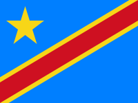
    Flag of the Democratic Republic of the Congo
    Official Country Name:  
    Democratic Republic of the Congo (English)
    République démocratique du Congo (French) 
    Short Names:  
     • Congo-Kinshasa (English, French)
     • DR Congo / DRC (English)
     • RD Congo / RDC (French)
    Capital: Kinshasa

    The Height of M23 Control

    The rebels’ territory reached its greatest extent in late 2012, when they rolled almost unopposed into the provincial capital of Goma on November 20. By this time, they already held Rutshuru, the largest town immediately north of Goma, as well as the Bunagana border crossing with Uganda.

    On the northern front, they had extended their control as far as the towns of Mabenga and Nyamilima, even briefly reaching the more distant Ugandan border town of Ishasha according to some reports. After taking Goma, they extended their control east through Sake and south along the road to South Kivu province.

    Withdrawal of Forces

    Based on the terms of an internationally brokered agreement, M23 pulled back out of Goma and Sake at the beginning of December 2012. The next several months saw little conflict with the army, though infighting among the rebels resulted in the expulsion of a faction loyal to alleged war criminal Bosco Ntaganda, who then unexpectedly turned himself in at the US embassy in Rwanda.

    By summer of 2013, fighting with the government had ramped up again. Though M23 initially had maintained positions just north of Goma, they were slowly pushed back with the help of a newly-authorized “intervention brigade” within the DRC’s UN peacekeeping mission. By the end of August the army had retaken the Goma-Rutshuru road as far as Kibati, with M23 forces retreating towards Kibumba. At some point the rebels appear to have abandoned their northern territories in Mabenga and Nyamilima as well, though it’s unclear exactly how and when that happened.

    The Defeat of M23

    Another lull in the fighting came to an end in late October 2013, when DRC and UN forces launched a series of rapid attacks on M23’s core territory. Troops advancing north from the direction of Goma quickly captured Kibumba and Rumangabo, while on the northern front the rebels were forced from Kalengera, Kiwanja, and their administrative headquarters in Rutshuru. Just five days after the fighting began, the DRC army took Bunagana on the Ugandan border, the last town under M23’s control.

    After being driven from all its towns, M23 retreated to a small triangle of territory with positions on the hills of Mbuzi, Tshanzu, and Runyoni. The army pounded the rebel positions with artillery, first taking Mbuzi before finally claiming victory at Tshanzu and Runyoni on November 5. The remaining rebels of M23 surrendered that day to the Congolese forces, ending their 20-month rebellion. Attempts were made to arrange a formal peace agreement, but the DRC government refused to sign anything that might imply recognition of M23 as a legitimate organization. Regardless, the surrender has held so far, and government and UN forces have turned their attention to the many remaining armed groups in the region.

    Photos: The Last Days of M23

    Regional Support

    Though both countries have staunchly denied it, M23 had well-documented support from Uganda and especially Rwanda, with some reports saying it even took orders directly from the Rwandan government. Rwanda has supported previous Tutsi-led rebel groups as well, often allegedly seeking to combat ethnic Hutu militants who fled to the Congo after perpetrating the Rwandan genocide of 1994. M23’s real motives were never perfectly clear, with some suggesting its primary purpose was to maintain a sphere of Rwandan control in the Congo. Likewise, its rapid retreat in October 2013 was likely connected to a loss of support from Rwanda, which had been facing increasing international pressure to end the conflict.

    Graphic of the flag of the Democratic Republic of the Congo is in the public domain (source).

    Map incorporates data from: Jarvis A., H.I. Reuter, A. Nelson, E. Guevara, 2008, Hole-filled seamless SRTM data V4, International Centre for Tropical Agriculture (CIAT), available from http://srtm.csi.cgiar.org