Iraq Control Map & Timeline: “Islamic State” Loses Last Towns – November 2017 (Subscription)

SUBSCRIBERS CLICK HERE TO PROCEED TO ARTICLE AND MAP

There are newer versions of this map available. To see them, view all Iraq updates.

Research by Djordje Djukic. Map by onestopmap.com, Evan Centanni, and Djordje Djukic

Subscribe for full access to all conflict map reports!


Detailed map of territorial control in Iraq as of November 29, 2017 after the recapture of Rawa, Qaim and government seizure of additional Kurdish-held territories. Shows territory held by the so-called Islamic State (ISIS, ISIL), the Baghdad government, the Kurdistan Peshmerga, and the Yezidi Sinjar Alliance (YBS and YJE). Colorblind accessible.
Since mid-October, government forces have recaptured the last towns in Iraq controlled by the so-called “Islamic State” (ISIS/ISIL), even while taking more territory from the Kurdistan Region in the wake of its controversial independence vote.

See all this and more on the latest update to PolGeoNow’s concise, professional map of control in Iraq’s civil war, including a timeline of changes since our previous Iraq map report of October 2017.

This map and report are premium content, available to paid subscribers of the PolGeoNow Conflict Mapping Service.

Want to see before you subscribe? Check out our most recent FREE SAMPLE Iraq map report!

Exclusive report includes:

  • Up-to-date map of current territorial control in Iraq, color-coded for the Iraqi government, “Islamic State” (ISIS/ISIL) fighters, Kurdistan’s Peshmerga forces, and Yezidi militias. Colorblind accessible.
  • Detailed indication of town-by-town control, including all major cities and many smaller ones, as well as terrain, major roads, and provincial boundaries
  • Timeline of changes to the situation since mid-October, compiled by our Iraq-Syria specialist, with links to sources

SUBSCRIBERS CLICK HERE TO PROCEED TO ARTICLE AND MAP

Not signed up yet? Click here to learn more about our professional subscription service!

Can I purchase just this map?
This map and report are not available for automated purchase to non-subscribers. If you need access or republication rights for only this map report, contact service@polgeonow.com for options.
Philippines: No More “Islamic State” Control in Marawi

Article by Evan Centanni

(Subscribers click here to view this article in the members area.)

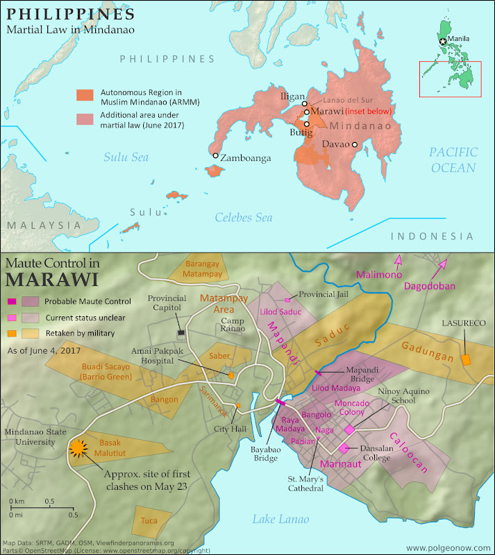
Map of so-called Islamic State (ISIS/ISIL) control in the Philippines, during the May-June 2017 crisis involving the Maute group and Abu Sayyaf takeover of Marawi Ciy, Lanao del Sur province, Mindanao. Updated to June 4, 2017, shows detailed control of Marawi by barangay. Includes map of area affected by martial law declared by President Rodrigo Duterte. Colorblind accessible.

Rebel Takeover in Southern Philippines

In early June, we published a detailed map and timeline of control in the Filipino city of Marawi, which had been partly captured by rebel fighters claiming to representing the so-called “Islamic State” (IS; formerly ISIS/ISIL). In a matter of hours, hundreds of religious hardline fighters had launched a surprise takeover of the city, led by the recently-formed Maute rebel group and Isnilon Hapilon, a leader of the radical Abu Sayyaf network and the IS’s officially designated leader for the Philippines.

The Filipino military quickly moved in to expel the fighters from Marawi, but the battle would drag on for another 5 months before the city was restored to full government control. As part of the government response, President Rodrigo Duterte declared martial law across the entire southern Philippines. For more on the history of martial law in the Philippines, and rebellions in the country’s south, see our article from June.

IS-affiliated Rebels Expelled from Marawi

The siege of Marawi City finally came to an end on October 23, exactly five months after it started, with the capture of the last rebel-held building by the Armed Forces of the Philippines. Over a thousand people had been killed in the fighting, including 165 military and police personnel, over 900 rebel fighters, and dozens of civilians. The three leaders of the insurrection, Hapilon and the two Maute brothers, were among the dead.

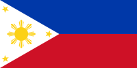
Flag of the PhilippinesCountry Name:  
• Philippines (English)
• Pilipinas (Filipino)
Official Name:  
• Republic of the Philippines (English)
• Republika ng Pilipinas (Filipino)
Capital: Manila

President Duterte’s martial law declaration remained in effect, having been extended by the legislature until the end of 2017. As of November, it was not yet clear whether the declaration would be extended again. The military hopes to continue its momentum in batting down other hardline rebel groups in the southern Philippines, such as the Bangsamoro Islamic Freedom Fighters (BIFF).

However, the region’s most prominent rebel force, the Moro Islamic Liberation Front (MILF), reportedly fought alongside government troops against the IS-inspired fighters. The MILF and the Filipino government had already been partway through implementing a drawn-out peace deal at the time the violence erupted in Marawi.

For a timeline of events in Marawi since our June 4 report, see Wikipedia’s well-sourced Battle of Marawi article (sources can be verified using the footnote citations for each timeline entry).

Want to know more? Read PolGeoNow’s in-depth June 2017 article on the rebel takeover of Marawi!

Graphic of the flag of the Philippines is in the public domain (source).

Syrian Civil War Map & Timeline: “Islamic State” Exits Last Major City – November 2017 (Subscription)

SUBSCRIBERS CLICK HERE TO PROCEED TO ARTICLE AND MAP

There are newer versions of this map available. To see them, view all Syria updates.

Research by Djordje Djukic. Map by onestopmap.com, Evan Centanni, and Djordje Djukic

Subscribe for full access to all conflict map reports!


Map of Syrian Civil War (Syria control map): Fighting and territorial control in Syria in November 2017 (Free Syrian Army rebels, Kurdish YPG, Syrian Democratic Forces (SDF), Jabhat Fateh al-Sham / Hayat Tahrir al-Sham (Al-Nusra Front), Islamic State (ISIS/ISIL), and others). Includes Russia-Turkey-Iran agreed de-escalation zones and US deconfliction zone, plus recent locations of conflict and territorial control changes, such as Deir ez-Zor, Abu Kamal (Al Bukamal), Markadeh, Quriyah, and more. Colorblind accessible.Over the past few weeks, the so-called “Islamic State” (ISIS/ISIL) has been completely driven out of its last major city, Deir ez-Zor, and now only controls a few smaller towns and the surrounding desert. Its enemies, the Russia-backed Syrian government and the US-backed Syrian Democratic Forces (SDF), are both moving in to take its place.

See all this and more on the latest update to PolGeoNow’s concise, professional Syrian Civil War control map, which includes a timeline of changes since our previous Syria map report in October, with sources cited.

This map and report are premium content, available to paid subscribers of the PolGeoNow Conflict Mapping Service.

Want to see before you subscribe? Check out our most recent FREE SAMPLE Syria map!

Exclusive map report includes:

  • Up-to-date illustration of current territorial control in Syria, color-coded for the Assad government, rebel groups, “Islamic State” (ISIS/ISIL) fighters, and Kurdish/SDF forces. Colorblind accessible.
  • Markers showing the approximate locations of Russian-Turkish-Iranian “de-escalation zones” and the one known US “deconfliction zone”.
  • Special symbols indicating towns dominated by rebels of the former Al Qaeda Nusra Front (now Hayat Tahrir al-Sham) and US-backed Syrian Democratic Forces (SDF).
  • Detailed indication of city-by-city control, including key towns and other locations important to current events.
  • Locations of recent fighting and other important events, including Deir ez-Zor, Abu Kamal (Al Bukamal), Markadeh, Quriyah, and more.
  • Detailed timeline of important events and changes to territorial control since October 26, 2017, compiled by our Syria-Iraq expert, with links to sources.

SUBSCRIBERS CLICK HERE TO PROCEED TO ARTICLE AND MAP

Not signed up yet? Click here to learn more about our professional subscription service!

Can I purchase just this map?
This map and report are not available for automated purchase to non-subscribers. If you need access or republication rights for only this map report, contact service@polgeonow.com for options.