Libya Changes Official Name

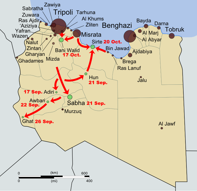
Map of rebel campaigns during the last stage of Libya's 2011 civil war
Map of the last stage of Libya’s 2011 civil war (click to see full map and original article). Map by Evan Centanni, based on public domain map from Wikipedia (source).

State of Libya
Last month, the North African country of Libya changed its official long-form name to “State of Libya” (Arabic: Dawlat Libya). This comes as part of Libya’s governmental transition following its 2011 civil war, in which a rebel coalition defeated the regime of dictator Muammar Gaddafi.

Over the last year, the country’s formal name had not been clearly defined, with the country referred to in most documents simply as “Libya”. The rebel National Transitional Council had only made a point of ceasing to use the Gaddafi-era name.

During the last decades of Gaddafi’s reign, the country was known in long form as the “Great Socialist People’s Libyan Arab Jamahiriya”. The word “jamahiriya” was coined by Gaddafi by combining the Arabic words for “republic” (jumhuriya) and “the masses” (jamahir).

The new name, “State of Libya”, voted in by the country’s General National Congress on January 8th, is intended to be temporary pending the approval of a new national constitution. However, it is entirely possible that the constitution, once drafted, could also choose to use the same name.

This marks the third year in a row that a country has changed its official name during the year’s first two months: last January, the Republic of Hungary changed its name to just “Hungary”, and in February 2011, the Republic of the Fiji Islands shortened its name to “Republic of Fiji”.

Catalonia: Europe’s Newest Nation?

Even relatively stable Europe hosts its share of geopolitical tensions: Catalonia, a major region of Spain which has long claimed a unique national identity, may now be on the path towards independence. Read on for a profile of what could become one of the world’s newest countries.

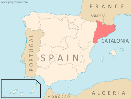
Map of Catalonia's location within Spain and relative to neighboring countries
Map by Evan Centanni, based on this map by Mutxamel. License: CC BY-SA

By Omar Alkhalili

What is Catalonia?

Catalonia is an autonomous community of Spain. It holds the official status of a nationality within the Spanish parliamentary monarchy. Regions of Spain with this status are considered to be something similar to countries within the larger Spanish nation, allowing for their own separateness from Spanish mainstream culture without actually being considered independent.

The region’s political administration consists of four provinces and extends over a large part of the historical Principality of Catalonia, which also included a piece of what is now southern France. Its capital is Barcelona, the largest city in Spain after Madrid and the sixth-largest in Europe. Catalan, Spanish, Aranese Occitan and Catalan Sign Language are all officially recognized languages.

Early in Catalonia’s history, it was ruled by Greeks, Carthaginians, the Romans, the Visigoths and the Islamic Moors. After a period of Frankish administration, the region would become a self-governing principality, ruled by the Count of Barcelona under the Crown of Aragon. It was during this time that Catalonia began producing a uniquely Catalan culture. The principality unified with the Crown of Spain but maintained self rule. During the War of the Spanish Succession, King Philip V brought an end to Catalan self-rule, incorporating it fully under the Spanish monarchy.
Flag of the autonomous community of Catalonia Region Name:  
• Catalonia (English)
• Catalunya (Catalan)
• Cataluña (Spanish)
• Catalonha (Occitan)
Official Status:  
Autonomous Community & Nationality within Spain
Capital: Barcelona

In the 20th century, Catalonia would have varying degrees of cultural independence. After the Spanish Civil War, military leader Francisco Franco banned Catalan language and culture. After World War II, Spain would see booming economic growth (the so-called the “Spanish Miracle”) with Catalonia both contributing to and benefiting from this rapid growth. With the end of Franco’s rule came the transition from dictatorship to democracy, which resulted in Catalonia being granted political, cultural and linguistic autonomy under the Spanish constitution.

The Path to Independence

Though calls for Catalan independence arguably have older origins, the formation of pro-independence political parties began early in the 20th century and continued during the oppressive rule of the Franco regime. Along with political parties, armed groups came into existence, some of which were considered by the Spanish authorities to be terrorist organizations. Terra Lliure, the Catalan Liberation Front and the Catalan Red Liberation Army were some of those organizations. By the 1990s, however, many of them had been disbanded.

One proposed flag for an independent Catalonia
A Catalonian independence flag. By Huhsunqu (CC BY-SA; source)

Decades later, the global recession hit Spain particularly hard, and the economic downturn has rejuvenated Catalan nationalist aspirations. While the Catalan national holiday of Diada de Catalunya usually draws crowds of people no larger than 50,000, 2012’s celebration brought an estimated at 1.5 million. While polling suggests that only 25.2% of Catalans wanted outright secession from Spain in 2010, a surprising 51.1% wanted the same thing in 2012. The situation is further inflamed by a dispute between Catalonia and the Spanish federal government: 19.49% of Spain’s tax revenue comes from Catalonia, but only 14.03% is reciprocated by state spending. In November of 2012, Catalans voted in an election which gave pro-independence parties the majority of seats in the Catalan government. These parties wish to hold a referendum on independence for the region.

If Catalonia was Independent

How would Catalonia fare if it were to become an independent country? The new nation would have a population of 7.5 million people, making it the 99th most populous country or territory in the world. The total land area of the country would be 32,114 km2, making it the 140th largest country or territory. The gross domestic product of the Catalonia region is US$314.4 billion, which would make it the 34th largest economy in the world if it were independent today. If it were granted membership in the European Union, the economy of Catalonia would be the bloc’s 14th largest.

Map of Catalonia's location within the European Union
Catalonia’s place in the EU. Map by Evan Centanni, from this blank map by Ssolbergj. License: CC BY-SA

Spain would be a loser in this transition in more ways than one. To begin with, it would lose approximately 16% of its population. Approximately 6.3% of Spain’s territory would be lost as well, and its GDP of US$1,494 billion would be reduced by 21%. On top of it all, the federal government would lose an important region from which significant state revenues are generated.

Other than the need to recover from economic troubles affecting all parts of Spain, there might be several issues faced by an independent Catalonia. What would be the cultural identity of this new country? Catalonia is not a homogenous region and many (46.53%) speak primarily Spanish, over Catalan and other languages. Though a majority now supports partition, a large minority of citizens do not necessarily support independence and may not react well to such a separation. Were Catalonia to become an independent state, such an important political move being supported by such a slim majority might prove to have a destabilizing effect.

Finally, the assumed admission of this new country into the European Union is just that: an assumption. Political partitions do not tend to go over smoothly, so Catalonia’s separation from Spain could foster a lot of resentment from non-Catalan Spaniards inside and outside of Catalonia. Since current EU members must all agree on the admission of new states to their union, a resentful Spain might block such an attempt at admission, which would certainly have political implications as well as possible economic effects.

Omar Alkhalili is a contributor to Political Geography Now. He is a graduate of Ramapo College of New Jersey with a Bachelor of Arts Degree in Political Science. He can be reached at omaralkha@gmail.com.

Graphic of current Catalonian flag by Wikimedia Commons user Martorell (License: CC BY-SA; source).

The Political Geography of Chocolate – A Valentine’s Day Special

Valentine’s Day is just around the corner, and if you thought you were getting a break from geography for sweets and smooching, think again! Political Geography Now presents an introduction to chocolate-based global intergovernmental organizations…

World map showing membership in chocolate-related intergovernmental organizations, the Alliance of Cocoa Producing Countries (COPAL) and the International Cocoa Organization (ICCO)
Map by Evan Centanni, starting from public domain blank world map (source).

International Chocolate Organizations
You’ve heard of the U.N., the E.U., and the WTO – but those are only some of the most well-known (i.e. boring!) global intergovernmental organizations. This Valentine’s Day, you can take a few minutes to learn about the political geography of chocolate – we’ll look at two organizations built around the global trade in cocoa beans, the raw ingredient used in making our favorite sweets.

The Alliance of Cocoa Producing Countries (COPAL)
The older of the two major chocolate-related intergovernmental organizations, COPAL is a club exclusively for countries that produce and export cocoa (and apparently have trouble with word order when forming acronyms). Founded by a core group of five countries in 1962, the organization is involved in activities such as scientific research, economic coordination, and promotion of chocolate products. Since its formation, COPAL has doubled in size, with a current total of ten member countries:

Logo of the Alliance of Cocoa Producing Countries (COPAL) Organization Name:  
• Alliance of Cocoa Producing Countries
Founded: 1962 in Abidjan, Ivory Coast
Headquarters: Lagos, Nigeria
Website: www.copal-cpa.org

Africa
 Cameroon
 Côte d’Ivoire (Ivory Coast)
 Gabon
 Ghana
 Nigeria
 São Tomé and Príncipe
 Togo

Americas
 Brazil
 Dominican Republic

Asia
 Malaysia

COPAL may be the oldest player in the world of international chocolate organizations, but it’s not the biggest…

International Cocoa Organization (ICCO)
The International Cocoa Organization, which exists peacefully alongside COPAL (and also uses a questionably-derived acronym), has a much broader geographical scope. Founded in 1973, the ICCO is structured around a series of global International Cocoa Agreements, with a mission to develop what it calls “sustainability” for the cocoa industry.

Issues the ICCO deals with include sustainable production and trade of cocoa beans, fair pay for cocoa farmers, and market transparency through the collection and disbursement of statistical data for the current “cocoa year” and beyond. The organization includes both cocoa exporting countries and cocoa importing countries, with membership closely tied to participation in the International Cocoa Agreements. If you happen to be a country, and you want to join the ICCO, there’s a nifty how to join PDF file for download from the website.

COPAL countries can also be part of the ICCO, and most are (let’s call those ones “double chocolate” countries). The ICCO is currently transitioning from the 2001 agreement to the more recent 2010 agreement as a basis for membership. Taken together, here are all the members of the ICCO, as well as countries which have signed the agreements but not yet advanced to full membership:

Logo of the International Cocoa Organization (ICCO) Organization Name:  
• International Cocoa Organization
Founded: 1973 in Geneva, Switzerland
Headquarters: London, UK
Website: www.icco.org

Africa (Exporting)
 Cameroon
 Côte d’Ivoire (Ivory Coast)
 Democratic Republic of the Congo
 Gabon
 Ghana
 Guinea
 Liberia (not yet full member)
 Nigeria (2001 agreement only)
 Sierra Leone (transitioning to 2010 agreement)
 Togo

Americas (Exporting)
 Brazil (transitioning to 2010 agreement)
 Costa Rica (not yet full member)
 Dominican Republic
 Ecuador (2001 agreement only)
 Nicaragua (2001 agreement only)
 Trinidad and Tobago (transitioning to 2010 agreement)
 Venezuela (2001 agreement only)

Asia (Exporting)
 Indonesia
 Malaysia (2001 agreement only)

Oceania (Exporting)
 Papua New Guinea (2001 agreement only)

Europe (Importing)
 European Union (27 countries)
 Russia (2001 agreement only)
 Switzerland

The Global Cocoa Trade
In fact, the worldwide cocoa industry is bigger than just these two organizations. Though all of the top cocoa-producing countries are members of the ICCO, a few smaller exporters are not. Conversely, membership doesn’t imply that a country is among the top producers – some member countries produce only a relatively small amount.

Although most of the world’s top cocoa bean importers are ICCO members, there’s one missing from the roster: the United States. Another top importer, Malaysia, has membership only as an exporting country. Outside the world of intergovernmental relations, there are also a number of non-governmental organizations dedicated to managing or influencing the global chocolate industry.

So next time you’re munching on some tasty chocolate, remember all the geography that went into its production! Yum!

(COPAL and ICCO logos are displayed without permission, based on fair use principles.)

Central African Republic Rebels Join Government (February 2013)

Map of rebel control in the Central African Republic, updated for the reported occupation of Dimbi and Kembe towns after the January 2013 ceasefire
Updated Central African Republic rebel control map. Fact-checked and modified by Evan Centanni from this map by Wikimedia user Keitsist. License: CC BY-SA

Unity Government Announced
After taking control of much of the country in December and January, rebels in the Central African Republic have been given a place in a new unity government that was announced last Sunday. The formation of this government will officially end the country’s period of division between the old administration and the “Séléka” rebel coalition.

However, it remains to be seen whether the Central African Republic will truly be reunited in terms of the facts on the ground. Insecurity and chaos has continued at reduced levels since the ceasefire of January 11, with one band of rebels even attacking two more towns during the interim (see updated map at right).

For the full story of Séléka’s lighting-fast campaign to control the country, see our previous article Central African Republic: Map of Rebel Control.

Updated Map: Central African Republic – Map of Rebel Control (March 2013)

Partner Project: Range of Taiwan’s Missiles

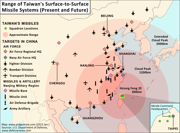
Map of Taiwan's missile capabilities, created for Taiwan in Perspective (https://michalthim.wordpress.com)
Click to see at full size on Taiwan in Perspective blog.
Map by Evan Centanni (all rights reserved).

Michal Thim from Taiwan in Perspective recently asked Political Geography Now to help him make a map depicting Taiwan’s current and future missile capabilities in its standoff with China. For anyone who’s interested, here’s the finished product (click on the map to see it at full size on Michal’s site). The main sources for the missile information was this article from Defense News, and the locations of China’s military assets come from the U.S. Department of Defense’s 2012 annual report on China.

If you want to learn more about the complex political situation in Taiwan, Wikipedia has a decent outline of the basics. Political Geography Now also hopes to publish maps and articles covering Taiwan in the future.

Mali Conflict Map: French Take Kidal, Other Towns (February 2013)

There are newer versions of this map available. To see them, view all Mali maps.  

This is an update of our Mali conflict map – for the original story, see Mali Map: Islamist Control & French Intervention.

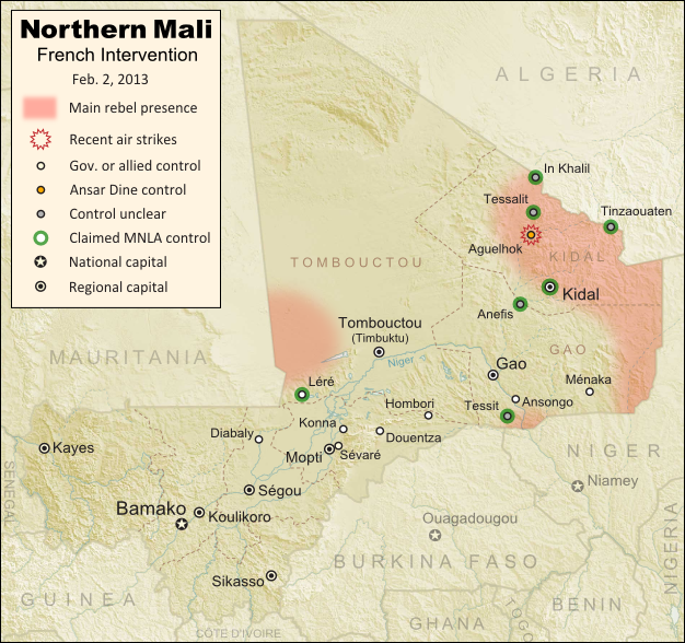
Updated map of fighting and territorial control in Mali during the January-February 2013 French intervention against the Islamist extremist rebel groups Ansar Dine and MUJAO. Reflects the situation as of February 2, when Kidal and other towns have been captured by French and African forces.
Updated map of territorial control and airstrikes in Mali, as of Feb. 2, 2013. Map by Evan Centanni, modified from Wikimedia map by Orionist, using images by Carport and NordNordWest (source). License: CC BY-SA.

French Troops Secure Kidal
After taking the two largest cities in Mali’s north over the last week, the French military by Thursday had also secured Kidal, the last of the area’s three major regional centers. The religious extremist rebels of Ansar Dine had apparently already fled the city, which was instead occupied by two moderate rebel organizations, the MIA and the MNLA, the latter of which originally took over the north last spring before being driven out by religious extremist groups.

The MNLA rebels, who were originally a Tuareg-led separatist movement (and even declared an independent country in their territory), have reemerged since the French intervention began, with an apparent willingness to negotiate for limited autonomy within Mali. If fact, they did not resist the French takeover of Kidal, saying they only refuse occupation by the Malian army itself, which they claim has long abused the Tuareg and Arab people of the far north. They also claimed control of a number of towns in the region this week, though journalists have not been able to verify these assertions.

Flag of MaliCountry Name:  
• Mali (English, French, Bambara)
Official Name:  
• Republic of Mali (English)
• République du Mali (French) 
• Mali ka Fasojamana (Bambara)
Capital: Bamako

Meanwhile, two other major towns near Gao have also fallen out of rebel hands. Ansongo was taken on Tuesday by forces from Niger and Mali, while Ménaka was occupied by allied soldiers from Chad. The Chadian contingent makes up nearly half of the African foreign supporting force in Mali, and unlike the others is not a member of the West African regional bloc ECOWAS.

With the capture of all three major northern cities, and reports that most of the Niger River region has also been secured, the first phase of the intervention in Mali is coming to an end. The victorious French and Malian presidents made a celebratory visit to Timbuktu on Saturday, declaring that French soldiers would remain in the country only long enough for African forces to take over the peacekeeping mission.

The extremist rebels have apparently fled into the desert, with Ansar Dine (or what’s left of it after its split with the MIA) believed to be hiding out in the mountains north of Kidal. The only town known to be under their control is Aguelhok, which was targeted by French airstrikes in recent days.

Besides the shrinking strongholds of Ansar Dine, several border areas appear to be under the influence of the MNLA rebels, though as mentioned before, they have not opposed the foreign intervention so far. MUJAO, the other major extremist group which had controlled towns in northern Mali, is apparently nowhere to be seen (for the moment anyway).

Original Story: Mali Map: Islamist Control & French Intervention

Further Reading: 
Islamists’ Harsh Rule Awakened Ethnic Tensions in Timbuktu
Niger agrees to host Mali-bound U.S. spy drones
Reuters Slideshow – Timbuktu Retaken

Additional Source for Map: France24 map – War in Northern Mali

Graphic of Malian flag is in the public domain (source).