African Union Reinstates Egypt and Guinea-Bissau (Map)

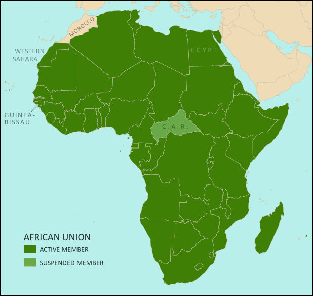
Map of the African Union, including active and suspended members, updated for the June 2014 reinstatement of Egypt and Guinea-Bissau (colorblind accessible).
The African Union as of July 2014. Map by Evan Centanni, from this blank map by Eric Gaba.
License: CC BY-SA

Premium members click here to view this article in the ad-free members area. Not a member yet? Subscribe now!

Article by Evan Centanni

Suspensions Lifted
At a meeting in June, the African Union (AU) decided to end the suspensions of Egypt and Guinea-Bissau from the regional organization. Egypt was suspended from the AU last year after its elected government was overthrown by the military. Its reinstatement comes after the events of this May, when the country held its first presidential election since the takeover. Guinea-Bissau had been suspended since a 2012 coup, and was similarly allowed back in after holding elections this April.

The AU’s Peace and Security Council typically suspends member countries when they experience coups or other breakdowns of constitutional rule. Though this is billed as a pro-democracy policy, it does not affect undemocratic governments which are already long-established. After Guinea-Bissau and Egypt’s reinstatement, there is currently only one remaining suspended AU member, the Central African Republic (CAR), which is experiencing serious turmoil in the aftermath of an aborted rebel takeover.
Flag of the African Union (AU)Organization Name:  
• African Union (English)
• al-Āthḥād al-’Āfrīqī (Arabic)
• Union africaine (French)
• União Africana (Portuguese)
• Unión Africana (Spanish)
• Umoja wa Afrika (Swahili)  
Launched: 2002 in Durban, South Africa
Headquarters: Addis Ababba, Ethiopia
Website: www.au.int

What is the African Union?
Formed in 1999-2002 to replace the earlier Organization of African Unity (OAU), the AU is an intergovernmental organization which works on increasing cooperation, stability, and development within the continent of Africa. It has a secretariat based in Addis Ababa, Ethiopia, though many of its most important decisions are made during annual summits of the continent’s national leaders.

Every UN-recognized country in Africa is a member of the African Union except for Morocco, which withdrew from the OAU in 1984 after the organization chose to admit the partially-recognized state of Western Sahara, a disputed territory which Morocco claims and largely occupies. The only other parts of Africa not represented in the AU are a few groups of offshore islands controlled by European countries, as well the small Spanish enclaves in North Africa. The breakaway Republic of Somaliland is not a member, but is considered by the AU to be part of member-state Somalia.

Low-resolution graphic of the African Union flag is displayed under fair use principles (source). Flag of Madagascar is in the public domain (source).

Map Update: Kosovo Recognized by 3 More Countries in 2014 (106/193)

Premium members click here to view this article in the ad-free members area. Not a member yet? Subscribe now!

Map of countries that recognize the Republic of Kosovo as an independent state, updated for July 2014, with most recent additions (Togo, Tonga, Lesotho) and disputed recognitions highlighted
Countries recognizing the Republic of Kosovo in green, highlighting recent additions. Disputed recognitions in yellow. Kosovo in magenta. Map by Evan Centanni, modified from public domain graphic (source).

Flag of the Republic of KosovoCountry Name:  
• Kosovo (English, Serbian)
• Kosova (Albanian)
Official Name:  
• Republic of Kosovo (English)
• Republika e Kosovës (Albanian)
• Republika Kosovo (Serbian)
Capital: Pristina/Prishtina

By Caleb Centanni

Kosovo Recognition Continues Growing
Over the last six months, three new countries have extended diplomatic recognition to the self-proclaimed Republic of Kosovo. The breakaway state, located in the Balkan Region of Southeastern Europe, is now recognized by at least 106 U.N. member nations (about 55%). Kosovo’s government claims recognition from 107 U.N. members, but one of these has been called into question (see “Disputed Recognitions” below).

The three new states which have recognized Kosovo are Tonga, in January; Lesotho, in February; and Togo, on July 2nd. Tonga is a Pacific Island state, Togo is a small country located in West Africa, and Lesotho is an enclave surrounded by South Africa. None of these countries’ governments appear to have confirmed their recognitions, with the information coming only from Kosovo’s foreign ministry. However, so far none of them has disputed Kosovo’s claims.

The Republic of Kosovo declared independence from Serbia in 2008, but has been blocked from U.N. membership by objections from Serbia, Russia, and other countries who see its secession as invalid. In addition to the 106 U.N. members recognizing Kosovo, its independence is also acknowledged by non-U.N. member Taiwan. For more on Kosovo’s special situation, see our first Kosovo recognition report, which also includes a map of Kosovo’s location relative to Serbia.

Disputed Recognitions
The African Island nation of São Tomé and Príncipe announced its recognition of Kosovo on March 13, 2012. However, on January 7, 2013, the President of the small country declared the recognition invalid on the grounds that he had not been informed of the decision. Despite this, Kosovo still maintains that the recognition is valid. Political Geography Now has chosen not to include São Tomé and Príncipe in its tallies of recognition until the dispute has been resolved.

In addition to this, Kosovo has previously claimed that two other African countries, Nigeria and Uganda, recognized its independence. However, Nigeria clearly stated in March that it did not recognize the breakaway state, and Kosovo’s foreign ministry recently included Uganda in a discussion of nations that “have not yet recognized Kosovo”, also indicating that there are only 107 U.N. members currently recognizing the country. Despite this, the ministry’s website has still not dropped Nigeria and Uganda from its list of “Countries that have recognized the Republic of Kosova”.

Stay Up to Date: Check for further news and map updates related to Kosovo’s recognition by viewing all Kosovo articles on Political Geography Now.

Related Articles:
Kosovo Recognition Map Update: October 2013
North Kosovo Status Changing After Serbia Deal
Who Recognizes Palestine in 2013?
 
Flag graphic by Cradel (source). License: CC BY-SA

War in Ukraine: Detailed Map of Rebel Control in Donetsk & Luhansk (Premium)

etailed map of rebel control in Ukraine's eastern provinces of Donetsk and Luhansk, claimed by the breakaway Donetsk People's Republic and Lugansk People's Republic. Updated to July 22, 2014

Download PDF
buy

(Subscribe via Paypal to view all premium content online)

All new, detailed map of rebel control in eastern Ukraine’s Donetsk and Luhansk regions, home to the claimed Donetsk People’s Republic, Lugansk People’s Republic, and Federation of Novorossiya. 

Since our last Ukraine update, pro-Russian rebels have captured much more territory in Donetsk and Luhansk regions, but also lost some of their early strongholds. 

This map report is exclusive premium content, available to paid subscribers or for individual purchase.
Buy now (US$9.99)

Premium map includes:

  • All new, detailed map of Donetsk and Luhansk regions, showing both past and current rebel control
  • Indication of which districts and cities have had their administrations occupied by separatists
  • Important locations of rebel military control marked
  • Article with chronology of events since April, and discussion of the meaning of “control”

MEMBERS CLICK HERE TO PROCEED TO ARTICLE AND MAP

NOT A MEMBER YET? SUBSCRIBE NOW!

Map: Yemen Joins WTO

Premium members click here to view this article in the ad-free members area. Not a member yet? Subscribe now!

Map of World Trade Organization (WTO) member and observer countries, updated for July 2014 to include new member Yemen
Member and observer states of the World Trade Organization (WTO). Map by Evan Centanni, starting from public domain blank map (license: CC BY-NC-SA).

By Caleb Centanni 

World Trade Organization Admits Yemen 

The World Trade Organization (WTO), a global organization founded in 1995 to promote the management and expansion of international trade, added Yemen as a new member in late June. This comes after the admission of four new members in 2012, and two more in early 2013.

Logo of the World Trade Organization (WTO) Organization Name:  
• World Trade Organization (English)
• Organisation mondiale du commerce (French)
• Organización Mundial del Comercio (Spanish)
Founded: 1994 in Marrakech, Morocco (commenced in 1995)
Headquarters: Geneva, Switzerland
Website: www.wto.org

Yemen, located on the southern Arabian Peninsula, was approved for membership last October at the Ninth Ministerial Conference of the WTO in Bali, Indonesia. The nation officially became a member on June 26, 2014, placing the entire peninsula under the organization’s representation. Yemen’s admission comes despite recent political turmoil in the country, including an Arab Spring uprising and rebel control of large areas of its territory. Yemen is the seventh least developed member country according to the WTO.

According to the WTO, 97.1% of the world economy now falls under the body’s jurisdiction, and this newest accession brings the organization’s membership to 160. Of the 195 UN-recognized countries in the world, 156 (exactly 80%) are members of the WTO. Another four members are not UN-recognized nations: the Chinese administered territories of Hong Kong and Macau, the European Union, and the disputed state of Taiwan, which participates under the name “Separate Customs Territory of Taiwan, Penghu, Kinmen and Matsu (Chinese Taipei)”.  

There are also 24 WTO “observers”, states that are partially included in the organization and have applied for membership (excepting the Holy See, which does not plan to apply). There are only 14 UN members which are neither members nor observers of the WTO.

WTO logo is displayed without permission, based on fair use principles (source).

Syria Civil War: Territorial Control Map #12.3 (Premium)

There are newer versions of this map available. To see them, view all Syria updates.

Detailed map of fighting and territorial control in Syria's Civil War (Free Syrian Army and Nusra Front rebels, Kurdish groups, ISIS/ISIL/Islamic State and others), updated to July 3, 2014.

Download PDF
buy

(Subscribe via Paypal to view all premium content online)

This is the Syria update you’ve been waiting for: our new map includes not only cities, but a full illustration of territorial control for each faction in the civil war. Also includes many updates to the situation since the last edition in April.

This map and article are exclusive premium content, available to paid subscribers or for individual purchase.
Buy now (US$9.99)

Premium map includes:

  • Up-to-date map of current territorial control in Syria, color-coded for the Assad government, rebel groups, ISIS/Islamic State extremists, and Kurdish self-protection forces
  • Detailed indication of city-by-city control, highlighting key towns relevant to current events
  • Includes recent areas of fighting including Deir ez-Zor, Abu Kamal, Mayadin, Khan Shaykhun, and many more
  • In-depth article summarizes changes since April, including ISIS’s declaration of an Islamic caliphate, with links to the sources of information

Members click here to proceed to article and map

Not a member yet? Subscribe Now!