Syrian Civil War Control Map & Report: November 2016

There are newer versions of this map available. To see them, view all Syria updates.
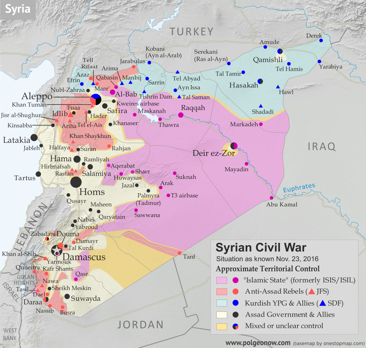
Map of fighting and territorial control in Syria's Civil War (Free Syrian Army rebels, Kurdish YPG, Syrian Democratic Forces (SDF), Jabhat Fateh al-Sham (Al-Nusra Front), Islamic State (ISIS/ISIL), and others), updated to November 23, 2016. Now includes terrain and major roads (highways). Includes recent locations of conflict and territorial control changes, such as Al-Bab, Khan al-Shih, Tal Saman, Qabasin, and more. Colorblind accessible.
Base map by Koen Adams of onestopmap.com, with territorial control by Evan Centanni and Djordje Djukic.
All rights reserved.

(Subscribers click here to view this article in the member area.)

Timeline by Djordje Djukic, with additional reporting by Evan Centanni

Situation Summary
In the past month since our previous Syrian Civil War map update, fighting has focused largely on the ongoing battle for the city of Aleppo, where rebels control a large enclave in the east, as well as a three-way fight for control of Al-Bab, the largest town in the countryside east of Aleppo (at least, according to pre-war census figures). Held for nearly three years by the so-called “Islamic State” (IS; formerly ISIS/ISIL), Al-Bab is now the target of both the Turkish-backed Free Syrian Army (FSA) rebels and the US-backed Syrian Democratic Forces (SDF) coalition led by Kurdish militias. The SDF has also made progress toward the IS capital of Raqqah in the east, while the Syrian Army of President Bashar al-Assad is making slow progress against rebels in the west of the country.

Flag of Syria under the current governmentCountry Name:  
• Syria (English)
• Sūriyya/Sūryā (Arabic)
Official Name:  
• Syrian Arab Republic (English)
• al-Jumhūriyyah al-‘Arabīyah  as-Sūriyyah (Arabic)
Capital: Damascus

Note: Red triangles on the map represent towns where rebel group Jabhat Fateh al-Sham (JFS), formerly known as Al Qaeda affiliate Jabhat al-Nusra (a.k.a. the Nusra Front), is thought to be in a dominant position among rebel forces, even if it doesn’t exercise exclusive control. This organization has some presence in almost every rebel-held area in Syria.

Timeline of Events
The following is a timeline of changes to territorial control and other key events in Syria since our previous map update of October 23, 2016. Sources are provided in the form of links.

October 26-27, 2016
The race for control of IS-held Al-Bab continued as Turkish-backed Free Syrian Army (FSA) rebels seized three villages from the group north of the town, while the Kurdish-led SDF captured four villages from the rebels (two west and two east of Al-Bab). With the advances, the rebels were 13 kilometers from Al-Bab, while the SDF was positioned at a distance of18 kilometers..

October 27, 2016
The Syrian Army recaptured the town of Suran, north of Hama, which it had lost to rebels at the end of August. Meanwhile, northeast of Aleppo, the race to the IS-held town of Al-Bab continued. The Kurdish-led SDF captured several villages from the Turkish-backed rebels, while the rebels themselves took control of several villages from IS.

October 28, 2016
The SDF and the Syrian Army jointly seized half a dozen villages from IS, northeast of Aleppo, and a former Infantry College came under the control of the army. Elsewhere, the army surrounded the rebel-held town of Khan al-Shih, southwest of Damascus.

October 28-November 12, 2016
Rebels launched an offensive on the government-held western part of Aleppo city in an attempt to break the siege of the rebel-held eastern section. In the first two days of the operation, they managed to capture the Minyan Sawmills, most of the Dahiyat al-Assad district and half of the Minyan district. During this period, 12 suicide bombers were used against government positions.

On November 3, the rebels launched the second phase of their offensive, attacking the New Aleppo district, but the assault was ultimately repelled. At this point, the rebel offensive slowed and on November 6, government forces launched a counter-attack in the southwest of the city. By November 12, pro-government troops had managed to reverse all rebel gains and additionally retake territory they had lost in the rebels’ summer offensive.

Between October 28 and November 11, 291 rebels and 146 pro-government fighters were killed in the offensive, along with 96127 civilians who died due to rebel shelling. An additional 350-400 rebels and 200-300 pro-government fighters were wounded. Pro-rebel media also reported nearly 500 civilian deaths from government shelling in eastern Aleppo.

October 30, 2016
The army captured Tal Kurdi, as well as one other nearby town, east of Damascus, further shrinking the rebel pocket known as Eastern Ghouta and coming closer to the rebel stronghold of Douma.

November 1-2, 2016
IS managed to recapture 17 villages from the Turkish-backed rebels northeast of Aleppo.

November 4, 2016
The army captured a village near the town of Khan al-Shih. Thirty-three rebels were reported killed in the area the previous day.

November 5, 2016
A rebel assault north of Hama resulted in the capture of several positions. However, an army counter-attack subsequently regained all lost territory.

November 6-15, 2016
The Turkish-backed rebels captured 36 villages from IS north of Al-Bab, advancing to within two kilometers of the town. On November 14, the rebels managed to enter the northern outskirts of Al-Bab, but were forced to withdraw one kilometer to the north of the town the next day. Concurrently, between November 11 and 15, the SDF captured 15 villages east of Al-Bab from IS, besieging the town of Arima.

November 6-22, 2016
On November 6, the SDF announced the start of the offensive to reach the IS capital of Raqqah. Within 15 days, they managed to seize 48 villages and farms from IS, including the strategic hilltop village of Tal Saman, 26 kilometers north of Raqqah. Following these advances, the SDF said Phase One of their offensive (cutting of Raqqah from its northern countryside) had been completed. The aim of Phase Two was to enforce a full blockade of the city. By November 22, the SDF was 20 kilometers north of Raqqah. At this point, the SDF threatened to halt the offensive if the US-led coalition did not force Turkey to halt attacks on SDF forces in the Manbij area.

The previous day, Turkish-backed rebels attacked and temporarily captured a village northeast of Al-Bab from the SDF, before the Kurdish-led forces managed to retake it.

November 8-13, 2016
The Syrian Army took control of a strategic road southwest of Damascus, tightening the siege of Khan al-Shih. Over the next five days, the town was hit with more than 140 barrel bombs and ground-to-ground missiles.

November 12, 2016
Government forces captured two villages south of Aleppo.

November 15-23, 2016
A new Syrian-Russian offensive on the rebel-held eastern part of Aleppo city was announced with heavy Russian airstrikes. By November 22, the military managed to seize a strategic hill overlooking the rebel-held Hanano district, half of Hanano itself, and 75 percent of the central Bustan al-Basha district. Reports said 159 civilians had been killed in the first seven days of the offensive. Of these, 143 died due to pro-government shelling and airstrikes, while 16 were killed by rebel shelling.

November 15-23, 2016
On November 15, rebels attacked the IS-held town of Qabasin, northeast of Al-Bab, and over the next eight days the town changed hands six times, ending up under IS control at press time.

November 17-19, 2016
The army managed to seize two areas west and east of Khan al-Shih before a surrender agreement was reached for the town’s rebel administration. Under the agreement, after a two-day ceasefire, 1,000 rebels would be evacuated to Idlib province and the town would be surrendered to the military.

November 20, 2016
The Assad government rejected a UN proposal to halt the fighting in Aleppo by granting the eastern half of the city autonomous status, which would have allowed the Syrian opposition to continue administering the area after a drawdown of rebel armed forces.

November 22, 2016
The head of Iran’s veterans’ affairs office confirmed more than 1,000 fighters sent from Iran to Syria have been killed since the start of the war. The number includes Iranian soldiers, as well as Afghan and Pakistani militiamen.

November 23, 2016
The Turkish-backed rebels captured three villages from the SDF and two from IS west and east of Al-Bab, while the SDF managed to seize the town of Arima from IS. In addition, the SDF took control of a village from IS west of Al-Bab.

Elsewhere, the Syrian Army launched an assault on a rebel-held mountainous area in Latakia province and managed to capture several positions before ultimately being repelled, with the rebels recapturing most of their lost territory. Meanwhile, it was reported that rebels in eastern Aleppo were preventing about 100 families, totaling 250 civilians, from crossing from the rebel-held part of the city into the Kurdish-held northern district to escape the government offensive.

Graphic of the Syrian flag is in the public domain (source).

The Czech Republic is Now Officially “Czechia” For Short

(Subscribers click here to view this article in the members area.)

Czech Republic Changes Official Name

Location of “Czechia” within the European Union
Map by David Liuzzo (CC BY-SA)

Last month, we wrote about a formal name change for the Gambia, a small country in Africa. But the Gambia wasn’t the only country to modify its official name this year: Europe’s Czech Republic also filed a name change with the UN, of a slightly different kind.

Rather than changing the details of its full name, as the Gambia did when it switched out “Republic of the Gambia” for “Islamic Republic of the Gambia”, the Czech Republic actually only changed its foreign language short name.

Long known for not really having a good short name in English, the Czech Republic now wants you to call it “Czechia” (pronounced “CHECK-ee-ah”) in all casual contexts. (The complete formal name is still “Czech Republic”.)

The Origins of Czechia

Regions of Czechoslovakia between WWI and WWII. Sub-Carpathian Rus’ became a part of Ukraine after WWII. (Public domain map by Panonian)

The modern Czech Republic has only been an independent country for the past 23 years. But the core of what’s now the Czech Republic was historically known to English speakers as “Bohemia” – or Čechy in the local language.

When it declared independence from the defeated Austro-Hungarian Empire at the end of World War I, the country named itself Czechoslovakia, after its two biggest ethnic groups, the Czechs and the Slovaks. When that country peacefully split in two in 1993, the eastern half quickly became known as “Slovakia”. But people couldn’t agree on a better English name for the western half than its full official designation, the “Czech Republic”.

Gradual Adoption of “Czechia”

In the Czech language, the new country was often known for short as Česko, from the first half of Česko-Slovensko, the native name of Czechoslovakia. Though Czech people are still getting used to it, today this name seems to have won out over the historical Čechy (Bohemia), because the modern country also includes historical Moravia and part of Silesia, both regions that weren’t part of Bohemia proper.

As for the English version, “Czechia” has reportedly been used by some branches of the country’s government since as far back as 1993 (and has been used occasionally by foreigners for hundreds of years). But the short English name has never really caught on, probably because Czech people themselves have often been reluctant to really get behind it. Still, it could be seen from time to time within the country itself.

Making “Czechia” Official Internationally

Tired of not having an agreed-upon short name for the country (competing suggestions included “Czechlands” or just “Czech”), the Czech government this year decided to go all the way with “Czechia”. After a joint endorsement of the name by the president, top ministers, and leaders of the legislature, the government moved to register an official name change at the United Nations (actually just adding a new short name alongside the formal full name of “Czech Republic”). 
 

Flag of Czechia (tje Czech Republic) Country Short Name:  
• Czechia (official English) 
• Česko (Czech)
Full Official Name:  
• Czech Republic (English)
• Česká republika (Czech)
Capital: Prague

By July, the new name was showing up in the United Nations UNGEGN country name database, and in September the new short name was added to ISO 3166, a standard list of country codes and names used by many organizations and businesses around the world (ISO isn’t associated with the UN, but uses the UN database as the main authority for world countries).   

Unlike Burma’s controversial change of English name to “Myanmar” in 1989, “Czechia” has earned quick acceptance from the governments of the world’s two most prominent English-speaking countries: the US and the UK. The British government announced in September that it was officially recommending the new short name, and the US government’s well-known CIA World Factbook website has also adopted the new name. 

But it’s hard to say how long it will take to catch on among average English speakers around the world. Ivory Coast’s name change to “Cote D’Ivoire” is still struggling to catch on outside diplomatic circles, even after 30 years. And if opinions within “Czechia” itself are anything to go by, it’s not off to a good start.
 

“Czechia” in Other Languages

In fact, the Czech Republic’s new short name isn’t only for English speakers. The UN has six official languages, and the country’s official short name has also been changed in the other five languages:

Language Before After
English the Czech Republic Czechia
French la République tchèque la Tchéquie
Spanish la República Checa Chequia
Russian Чешская Республика Чехия
Chinese 捷克共和国 捷克
Arabic الجمهورية التشيكةِ التشيك

Source: UNGEGN

For other languages, there’s no worldwide authority saying what you should call any given country. But as many have pointed out, some languages already have a popular short way of referring to the Czech Republic, such as the German Tschechien. PolGeoNow staff can also attest that Chinese 捷克 (also spelled Jieke, and pronounced roughly as “jayka”), was in widespread use even before the official name change.

Country Name Changes: Is This Normal?

Countries register official name tweaks with the UN at an average rate of about one per year, and it’s not unusual for a country to change its name only in English and other foreign languages, as Cape Verde did back in 2013. However, this may be the first time in modern history that a country has changed just its short name, without making any change to the full official name. Political Geography Now wasn’t able to find another such case in the entire history of the UN system – and before the UN was founded in 1945, we doubt there was any central place for countries to register official nicknames. But then, there’s no rule against it, so why not?

Graphic of the Czech flag is in the public domain (source).

Iraq Control Map & Timeline: The Siege of Mosul – November 2016 (Subscription)

SUBSCRIBERS CLICK HERE TO PROCEED TO ARTICLE AND MAP

There are newer versions of this map available. To see them, view all Iraq updates.

Research by Djordje Djukic. Map by onestopmap.com, Evan Centanni, and Djordje Djukic

Subscribe for full access to all conflict map reports!


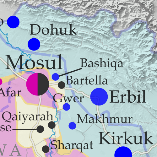
Detailed map of territorial control in Iraq as of November 4, 2016, including territory held by the so-called Islamic State (ISIS, ISIL), the Baghdad government, and the Kurdistan Peshmerga. Shows developments in the ongoing coalition battle to recapture the city of Mosul. Includes key locations from recent events, such as Bashiqa, Sharqat, and Bartella. Colorblind accessible. The battle is now on for Mosul, the so-called Islamic State’s (ISIS/ISIL) biggest city. A grand coalition of Iraqi military, Shiite and Sunni militias, and Kurdistan’s Peshmerga forces – with controversial help from the Turkish military – have now entered and mostly surrounded the city.
 
See all this and more on the latest update to PolGeoNow’s concise, professional map of control in Iraq’s civil war, including a timeline of changes since our previous Iraq map report of September 2016.

This map and report are premium professional content, available to paid subscribers of the PolGeoNow Conflict Mapping Service.

Want to see before you subscribe? Check out our most recent FREE SAMPLE Iraq map report!

Exclusive report includes:

  • Up-to-date map of current territorial control in Iraq, color-coded for the Iraqi government, “Islamic State” (ISIS/ISIL) extremists, and Kurdistan’s Peshmerga forces. Colorblind accessible.
  • Detailed indication of town-by-town control, including provincial boundaries, all major cities, and many smaller ones
  • Markers for key areas of recent fighting such as Mosul, Bashiqa, Sharqat, and Bartella
  • Timeline of changes to the situation since early September, compiled by our Iraq specialist, with links to sources

SUBSCRIBERS CLICK HERE TO PROCEED TO ARTICLE AND MAP

Not signed up yet? Click here to learn more about our professional subscription service!

Can I purchase just this map?
This map and report are not available for automated purchase to non-subscribers. If you need access or republication rights for only this map report, contact service@polgeonow.com for options.