Central African Republic: Map of Rebel Advance to Capital (March 2013)

Last January, rebels in the Central African Republic agreed to a ceasefire with the government, after taking over much of the country. Now, despite the formation of a unity government, the ceasefire has broken down and the rebels are once again advancing on the capital and other towns. Read on for a summary of events. Update (March 24, 2013): The Séléka rebel coalition has now taken the national capital, Bangui.

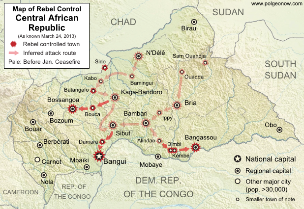
Map of 2012-2013 rebellion in the Central African Republic, showing current rebel control as of March 24, 2013, from the breakdown of the ceasefire up to the capture of the national capital city, Bangui
Advance of Séléka rebels in the Central African Republic, highlighting attacks occurring since the Jan. 11 ceasefire. Map fact-checked and expanded by Evan Centanni from this map by Wikimedia user Keitsist. License: CC BY-SA

Original Article: Central African Republic – Map of Rebel Control

Ceasefire Violations
After reaching a ceasefire with the government on January 11th, the Central African Republic’s Séléka rebel coalition began integration into a new unity government, with several rebel leaders receiving prominent positions in President François Bozizé’s cabinet. However, the violence did not end completely.

Bands of rebels attacked the southern towns of Dimbi and Kémbé less than two weeks after the ceasefire, and occupied the southern city of Mobaye for two weeks in February before finally withdrawing on the 20th. Another group attacked and took over the northern town of Sido on March 1st. By March 12th, the rebels in the south advanced once again to seize regional capital Bangassou.
Flag of the Central African RepublicCountry Name:  
• Central African Republic (English)
• Centrafrique (French)
• Bêafrîka (Sango)
Official Name:  
• Central African Republic (English)
• République centrafricaine (French)
•Ködörösêse tî Bêafrîka (Sango)
Capital: Bangui

Ceasefire Breakdown
On March 18th, it was reported that the Séléka rebels had “detained” their five ministers from the Central African Republic unity government, and issued a 72-hour deadline for their demands to be met. Sure enough, on March 20th a rebel spokesperson announced that the ceasefire had come to an end.

In the northwest, rebels claimed to capture Bouca and Batangafo soon afterwards (the latter had already been reported taken once in December). In the south, they continued onward toward the capital city of Bangui, seizing the town of Damara despite the presence of a multinational African peacekeeping force, which did not fire a shot. Meanwhile, they had captured yet another regional capital, Bossangoa, in the northwest.

Capital Seized by Rebels (update)
Today, March 24th, the Séléka coalition rebels reportedly took control of the national capital, Bangui, with President Bozizé fleeing across the border into the Democratic Republic of the Congo. It still remains unclear what will happen next. Stay tuned to Political Geography Now for further updates!

Graphic of the flag of the Central African Republic is in the public domain (source).
What is Vatican City?

This week, the Catholic Church chose a new leader, Pope Francis. The selection and announcement of the new pope took place in Vatican City, the Church’s sovereign territory within Rome. Is Vatican City really “the world’s smallest country”, or a country at all?  And what’s the difference between Vatican City and the Holy See? Read all about it!

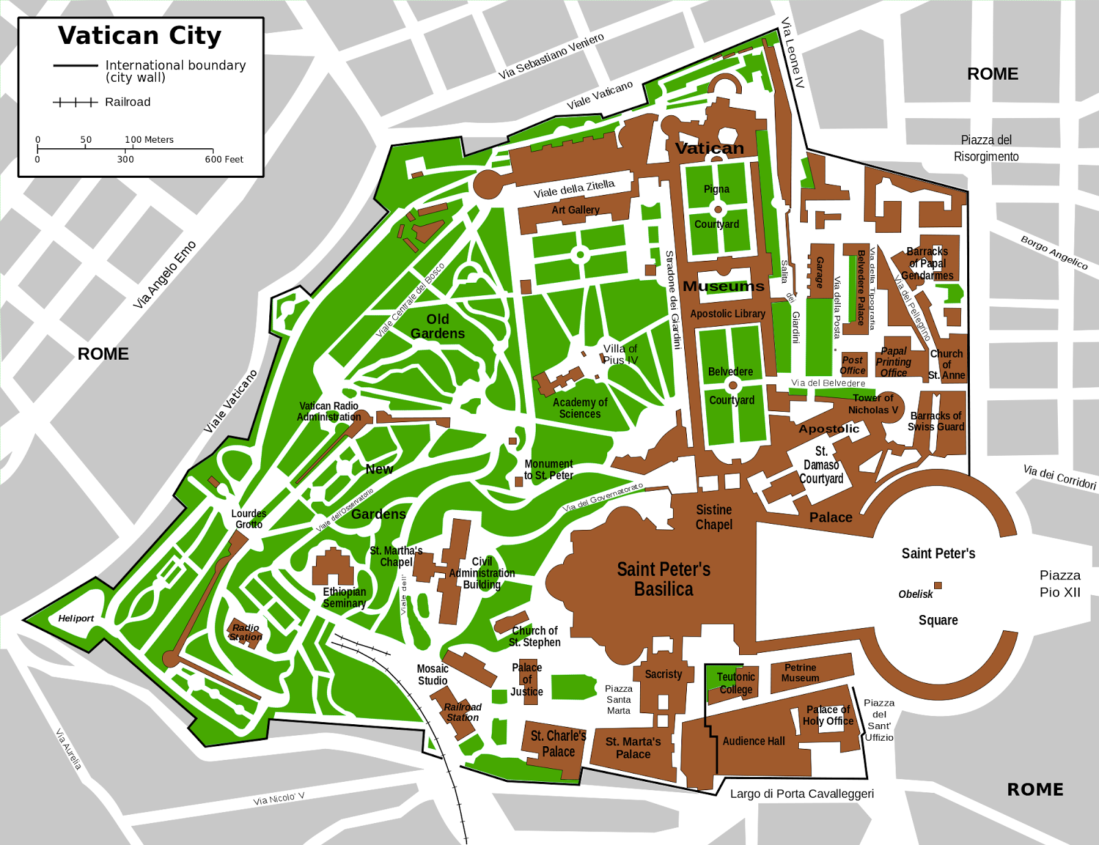
Large scale (close-up) map of Vatican City
Map of Vatican City (click to enlarge). By Francesco Piraneo G./Wikimedia Commons (CC BY-SAsource).

What is Vatican City?

Vatican City was created by the Lateran Treaty in 1929 to ensure the Catholic Church’s independence from the control of other countries, and has an area of only about 0.17 sq mi (0.44 sq km), or about one-eighth the size of Central Park in New York. In addition to the Pope, the state said to have a population of about 800, most of whom are either clergy or members of the Swiss Guard.

Located within the city of Rome, Vatican City is surrounded on all sides by Italy, and nearly encircled by a stone city wall except for in St. Peter’s Square, where it is separated from Italy only by a white line drawn on the ground. Various religious and administrative buildings are located within Vatican City’s confines, but more than half of its area is taken up by the green space of the Vatican Gardens.

Flag of Vatican CityCountry Name:  
• Vatican City (English)
• Città del Vaticano (Italian)
Official Name:  
• Vatican City State (English)
• Stato della Città del Vaticano (Italian)
Capital: Vatican City

Is Vatican City really a country?

Yes, technically. Although it doesn’t really have the kind of population and national cultural identity we would often expect from a “country”, it is recognized worldwide as a “sovereign state”, which means it rules itself and answers to no one else. This makes it by far the world’s smallest independent “country”, at less than a quarter the size of the runner-up, Monaco.

Vatican City’s supreme leader is the Bishop of Rome, a.k.a. the Pope, who is also head of the worldwide Catholic Church. And not only is its independence undisputed by the international community, but it actually maintains diplomatic relations with the U.N. and many countries – sort of. Vatican diplomacy is conducted not in the name of Vatican City itself, but directly by the Catholic Church in the name of the “Holy See”.

What’s the difference between Vatican City and the Holy See?

In short, Vatican City is a state (i.e. country), while the Holy See is a religious organization which happens to govern Vatican City, but has a broader purpose. In Catholic Church terminology, a “see” is the seat of authority of a particular bishop, and the “Holy See” refers to the authority of the Bishop of Rome (the Pope).

So the Holy See is the religious authority presiding over Catholic churches all across Rome (and by extension, the entire Catholic world), but it has normal government authority only in Vatican City and its “extraterritorial properties“. These properties, mostly churches or historical palaces located elsewhere in Rome, have a status similar to foreign embassies: they are technically part of Italy, but are under the legal jurisdiction of the Holy See.

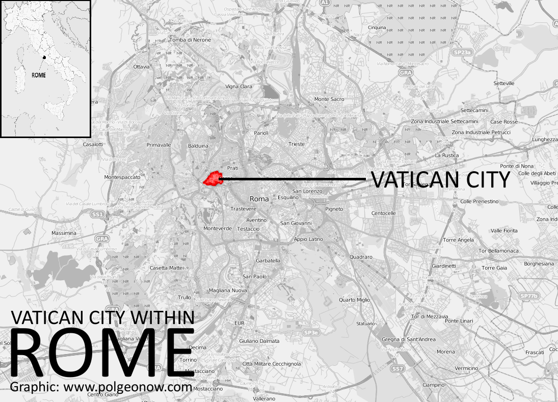
Map showing location of Vatican City within Rome
Vatican City’s location within Rome (click to enlarge). By Evan Centanni. Background map by Dr. Blofeld. License: CC BY-SAsource).

The term “the Vatican” can mean either Vatican City itself, or the Holy See, sort of like how “Washington” or “Beijing” can refer to the U.S. or Chinese governments rather than just the cities.

Bonus Facts

• Vatican City is the only undisputed country in the world which is not a member of the U.N. However, the Holy See does have status as a “permanent observer state” in the U.N. General Assembly. The only other U.N. observer state is Palestine, which just gained that status in November 2012.

• Although Vatican City was created only in 1929, the Holy See has existed for many hundreds of years. It was often recognized as a “sovereign entity” even when it had no territory, though at many points in history it did control territories much larger than today’s Vatican City.

• The Holy See’s official language is Latin, but Vatican City uses Italian as its state language. The Vatican’s only military force, the Swiss Guard, gives orders in German.

Graphic of the Vatican City flag is in the public domain (source).
Map: The Falkland Islands’ Disputed Seas

The Falkland Islands, a South Atlantic territory disputed between the U.K. and Argentina, held a status referendum this week in which 99.8% of voters defied Argentina by choosing to remain British. But it’s not just about the islands – also at stake are legal rights to the sea for hundreds of miles around.

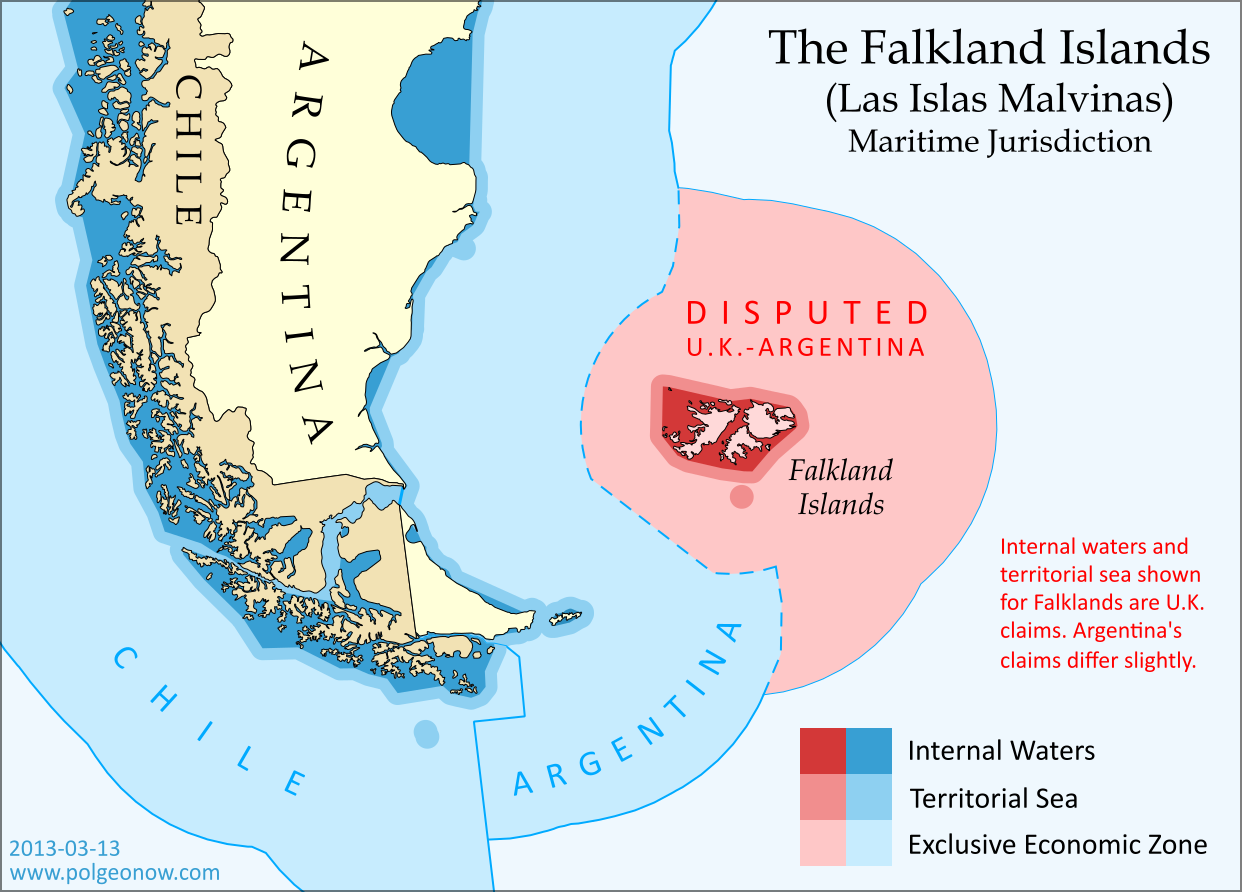
Map of maritime jurisdiction in the seas surrounding the Falkland Islands (Islas Malvinas), including territorial sea, internal waters, and exclusive economic zone (EEZ)
Zones of maritime jurisdiction around the Falkland Islands, highlighting area disputed between the U.K and Argentina. Map by Evan Centanni (country coastlines from the Natural Earth dataset). All rights reserved.

The Disputed Seas of the Falkland Islands
The Falkland Islands are administered by the U.K. as an overseas territory, but are also claimed based on historical arguments by Argentina, which calls them “las Islas Malvinas”. Both countries have signed and ratified the United Nations Convention on the Law of the Sea (UNCLOS), which defines ownership and legal rights for the waters surrounding coastal countries. According to the UNCLOS, each country is entitled to three basic zones of control in its surrounding seas:

Internal Waters
These areas normally include bays and the water between islands or between the islands and the mainland. With some exceptions, internal waters are considered legally equivalent to rivers and lakes, which means the country has total control here. Both the U.K. and Argentina claim an area of internal waters in the Falklands, though their claims are slightly different. Only the British claim is shown on the map above – the Argentine claim is a bit smaller, excluding the channel between the two main islands but stretching farther out to the most distant rocks.

Territorial Sea
The territorial sea is an area stretching up to 12 nautical miles out from the edge of the land or internal waters, which is considered sovereign territory of the state (i.e. an actual part of the country), though the “innocent passage” rule requires that foreign ships still be allowed to sail there without permission. Both the U.K. and Argentina claim a 12 nautical mile territorial sea surrounding the Falkland Islands. The two countries’ claims are slightly different because they’re drawn from the edges of the differing internal waters claims. The U.K. claim is shown on the map above (the small circle at the bottom is the territorial sea around Beauchene Island).

Flag of the Falkland Islands Territory Name:  
Falkland Islands (English)
• Islas Malvinas (Spanish)
Claimants: 
• United Kingdom (U.K.)
• Argentina
Actual Control: U.K.
Status: Overseas Territory (self-governing)
Capital: Stanley

Exclusive Economic Zone (EEZ)
Although the waters beyond the territorial sea are not considered part of the country itself, the country still has some legal rights over the surrounding ocean, up to a maximum distance of 200 nautical miles from the coast or internal waters. This is called the “exclusive economic zone”, and here countries can control the harvesting of resources, scientific research, and environmental protection. When two countries are less than 400 nautical miles apart, they have to come to an agreement about where to draw the border of their EEZs (the default is normally to draw a line halfway between the two coasts).

The Falklands are indeed less than 400 nautical miles from mainland Argentina, but the Argentine government doesn’t consider this to be a problem, because they consider both the mainland EEZ and the Falkland EEZ to be theirs. The U.K. also claims the waters around the Falklands (though it calls them a “fishery conservation zone” instead of an EEZ), but draws its line short of the halfway point between the islands and Argentina. This might be intended as a show of modesty, though Argentina isn’t flattered, since it doesn’t think the U.K. should be there in the first place.

The Continental Shelf
Beyond the end of the EEZ, countries are also allowed to claim economic rights to the seafloor (but not the water above it), if it is part of the “continental shelf”. The legal definition of this term is a bit different from the way geologists use it, but the basic idea is that if the continent or landmass extends out a ways underwater before giving way to the deep sea, the shallow area is the continental shelf.

This is limited to 350 nautical miles from the shore, as well as detailed rules defining the required depth and slope of the sea floor. But since the U.K. and Argentina both also claim South Georgia and the South Sandwich Islands (not to mention parts of Antarctica), their conflicting continental shelf claims continue southeast from the Falklands EEZ for hundreds of miles. If you’re interested in this extended disputed territory between the U.K. and Argentina, check out this excellent online map made by Durham University’s International Boundaries Research Unit.

Who Really Controls the Seas of the Falkland Islands?
Actual control of these seas follows the U.K.’s claims, since that’s the country that actually controls the islands. Argentina insists this is illegal, and even temporarily occupied the islands in 1982; but it’s unlikely control will change any time in the near future, since the U.K. insists it won’t go against the will of the islanders (most of whom are proudly British, and many of whom have bad memories of Argentina from the 1982 war).

Graphic of the Falkland Islands flag is in the public domain (source).

Syria Uprising Map: March 2013 (#9)

There are newer versions of this map available. To see them, view all Syria updates.

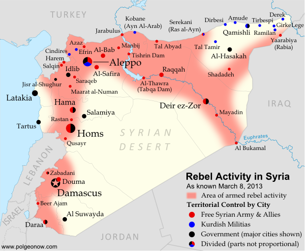
Syria’s civil war has continued to spread eastward across the country, with rebels taking two major towns over the last month. Below is the updated conflict map, plus a summary of recent territorial changes.

Map of rebel activity and control in Syria's Civil War (Free Syrian Army, Kurdish groups, Al-Nusra Front and others), updated for March 2013. Includes recent locations of conflict, including Raqqa, Al-Safira, Al-Hasakah, and Tabqa Dam.
Activity and cities held by rebels and other groups in Syria, updated for March 2013. Map by Evan Centanni, starting from this blank map by German Wikipedia user NordNordWest. License: CC BY-SA

Eastward to Raqqah
Since our last Syria map update, rebel forces have continued to move southeast from Aleppo (where fighting still rages), last month taking over the Tabqa hydroelectric dam. It was soon reported that they controlled the neighboring town of Thawrah as well. (“Tabqa” and “Thawrah” are actually two names for the same place; the latter is a more recent official name which means “revolution” in Arabic).

This week, the rebels reached Raqqah, apparently seizing nearly the whole city and capturing the provincial governor. This gives them almost complete control of an entire province, and is the first time they have held a provincial capital since losing Idlib city a year ago. It also effectively connects the two fronts of the war, with rebels now mostly in control of a stretch running all the way from Aleppo in the northwest to Al Bukamal in the southeast.

Flag of Syria under the current governmentCountry Name:  
• Syria (English)
• Sūriyya/Sūryā (Arabic)
Official Name:  
• Syrian Arab Republic (English)
• al-Jumhūriyyah al-‘Arabīyah  as-Sūriyyah (Arabic)
Capital: Damascus

Rebel and Kurdish Groups in the Northeast
Even as rebel forces moved east from Aleppo, another group struck out northwest from the Deir ez-Zor area, taking over the town of Shadadeh in Al-Hasakah province. This northeasternmost province is a major oil-producing region, but further conquests may come up against resistance from Kurdish militias, whose people form a large percentage of the population.

Indeed, Kurdish groups have continued to consolidate their power in Syria’s far northeast, seizing the town of Ramilan this week, and reportedly occupying most of Al-Hasakah’s oil fields. The Kurdish militias are not officially aligned with either side in the war, usually claiming to oppose the government, but keeping a wary eye on the rebels at the same time.

Last weekend, another battle was going on quite close to Ramilan. In what became a small international incident, rebels fought government forces for control of the northeastern border crossing to Iraq. According to some reports, the rebels gained control of Yaarabiya, the town on the Syrian side of the border; the crossing is also known as Rabia, after the town on the Iraqi side.

Fighting in Syria’s West
Also last month, rebels moved into Al-Safira, a major town just outside of Aleppo. They were soon reported to control of the streets, though fighting was ongoing against government forces just outside the town. In December, just after our last map update, there was also a major campaign near Hama, in which rebels took control of various small towns and villages north of the city, but lost several of them again within a few weeks.

The Al-Nusra Front
It is worth mentioning that rebel victories in Syria’s civil war have increasingly been attributed not to the Free Syrian Army, but to its ally the Al-Nusra Front (also known as Jabhat al-Nusra). This militant group, known for a long list of bombings as well as battles, is made up of religious fundamentalists who envision an Islamic state to replace the current Syrian government. The Al-Nusra Front has played a leading role in Al-Safira and Shadadeh in particular, succeeding partly through the skills of well-trained foreign fighters from other Arab countries like Libya, Iraq, and Saudi Arabia. It is suspected of ties with Al Qaeda.

Related Articles:

Central African Republic: Map of Rebel Advance to Capital

Graphic of Syrian flag is in the public domain (source).

Map: Laos and Tajikistan Join WTO

Map of World Trade Organization (WTO) member countries, updated for March 2013 to include new members Laos and Tajikistan
World Trade Organization members in green. New members Laos and Tajikistan highlighted (click to enlarge). Map by Evan Centanni, modified from this Wikimedia map by Muso (license: CC BY-SA).

Logo of the World Trade Organization (WTO) Organization Name:  
• World Trade Organization (English)
• Organisation mondiale du commerce (French)
• Organización Mundial del Comercio (Spanish)
Founded: 1994 in Marrakech, Morocco (commenced in 1995)
Headquarters: Geneva, Switzerland
Website: www.wto.org

World Trade Organization Continues Growing
The World Trade Organization (WTO), a global treaty-based organization formed in 1995 to manage and promote international trade, has admitted two new members in recent weeks. This follows the previous admission of four new members last year (which had been approved at the end of 2011).

Laos, a landlocked communist state in Southeast Asia, was approved for membership last October, after 15 years of unsuccessful efforts to join. The country, whose economy is very small but growing rapidly, officially became a member of the WTO on February 2nd. Laos was the last mainland Southeast Asian country to join the organization, meaning the entire region is now represented in the global body.

Tajikistan, a former soviet country in Central Asia, joined the WTO last weekend (March 2nd) after a 12-year-long campaign. The small country, which is also landlocked like Laos, was approved for membership in December. It is the second of the five ex-soviet Central Asian countries to join the organization, after Kyrgyzstan.

The World Trade Organization now has 159 members, including about 80% of the world’s countries, plus a few which are not independent countries, such as Hong Kong and the European Union (each of the EU’s members also has its own separate membership).

WTO logo is displayed without permission, based on fair use principles (source).