New Country: Azawad Declares Independence From Mali

Country Name: Azawad (English, Tuareg, French), Azawād (Arabic)
News Categories: New Countries, Breakaway States, Unrecognized States
Summary: Tuareg-led rebels in northern Mali have declared “the independent state of Azawad”, after taking control of all of the region’s major cities and military bases and advancing to near the edge of their claimed territory. Azawad is not recognized as an independent country by any U.N. members, making it an example of a so-called “breakaway state”.
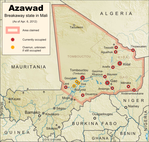
Map of the new independent state of Azawad, declared by MNLA Tuareg rebels in northern Mali. Shows claimed territory and towns controlled by the rebels group as of April 6, 2012
Map of State of Azawad, declared by the Tuareg-majority MNLA rebel group in Mali. Modified from Wikimedia map by Orionist, incorporating images by Carport and NordNordWest (source). License: CC BY-SA.

See Also: Mali Divided by Separatist Fighting; all Mali map updates

MNLA Claims Independent Azawad
The National Movement for the Liberation of Azawad (MNLA) today declared independence from Mali via a statement in French on its website. The rebels of the MNLA, mostly from the Tuareg ethnic group of the Sahara Desert, claim that the northern region of Mali, which they call Azawad, was wrongly included in that country when it declared its independence from France in 1960. There has not yet been any announcement on what form of government Azawad will have, or on which city will be its capital, but the MNLA says it is committed to democracy, to following the rules of the U.N., and to respecting the borders of other countries in the region.

Full Text: Declaration of Independence of Azawad (English Translation)

Flag of the independent state of Azawad, as claimed by the MNLA Tuareg rebel group in northern Mali
Flag of Azawad (image by Orionist; source)

The breakaway state of Azawad is not yet recognized diplomatically by any of the world’s other countries, and is unlikely to be any time soon. It joins the ranks of the various wholly or partially unrecognized states of the world, including fellow African state Somaliland, which similarly controls its whole territory despite complete lack of recognition from either the U.N. or other states. This status will likely prevent Azawad from appearing on mainstream world maps for some time to come.
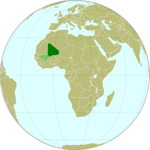
Map showing the location of the new state of Azawad in Africa, declared by the MNLA Tuareg rebel group in northern Mali
Azawad (dark green) and remainder of Mali (light green) in
Africa. Modified from this Wikimedia map (public domain).

Update on Territorial Control
Since our last map update, the Tuareg rebels of the MNLA advanced as far as the town of Douentza (according to their own claims, which have not been disputed), after which they declared a ceasefire, saying they had completed their mission to liberate Azawad. The town of Niafunké has also apparently switched hands a few times over the last few months (source in French), with its current situation unclear. The reality is that the Malian military probably no longer controls anything within the claimed territory of Azawad. Towns not shown as rebel-controlled on the map may simply not be occupied by anyone.

However, the new state of Azawad now faces a threat from another direction – the Islamist Ansar Dine militia, which fought alongside the MNLA over the last few months (with or without their approval). Ansar Dine is now attempting to install strict Sharia (Islamic law) in the cities, in opposition to the MNLA’s claimed desire for a secular state. An additional complication is that Ansar Dine in fact does not support independence for Azawad, believing instead that Sharia law should be instated throughout Mali. Ansar Dine is also a Tuareg-led group.

Seen this Mali conflict map on Wikipedia?
While Political Geography Now sometimes uses free maps from Wikipedia or other sites (after double-checking their sources), we also occasionally post our own maps to Wikipedia and Wikimedia Commons for others to use. The first version of this particular map of the Tuareg-led rebellion in Mali was created for Wikipedia by Orionist, but I have since taken charge of keeping it updated, with a bit of help from Mnmazur on Wikimedia Commons (Mnmazur is not associated with Political Geography Now).

Mali Conflict Map: Separatist Capture Timbuktu and Gao (April 2012)

Country Name: Mali (English, French, Bambara)
Official Name: Republic of Mali (English), République du Mali (French)
News Category: Divided Countries
Summary: Tuareg-led rebels in northern Mali have now completed their control of the region’s major cities, after capturing the military headquarters in Gao as well as historic Timbuktu. Meanwhile, Mali has been suspended from regional organization ECOWAS in response to the recent coup d’etat in the capital, Bamako.

Map of Tuareg rebellion in Northern Mali (Azawad), showing towns controlled by the MNLA rebel group as of April 1, 2012
Towns captured by the Tuareg-majority MNLA rebel group in Mali. Modified from Wikimedia map by Orionist, incorporating images by Carport and NordNordWest (source). License: CC BY-SA.

Full Story: Mali Divided by Separatist Fighting; all Mali map updates

Conflict Update
Again immediately following our last update, northern Mali’s National Movement for the Liberation of Azawad (MNLA), made up mostly of Saharan Tuareg people, has followed its victory in Kidal by capturing the region’s other two major cities. On March 31, the rebels took control of Gao, headquarters of the Malian military in the north, and the next day overran Timbuktu, a historic former trading post and modern tourism destination. The town of Aguelhok in the north is now also being reported as under Tuareg control, though it is unclear when it was recaptured (the rebels had previously taken and lost it again back in January).

The military government of Mali, which took over in a recent coup d’etat, has now withdrawn its forces from most of northern region, known to the Tuareg rebels as Azawad. Neighboring countries have offered military assistance only if the country returns to democracy, and have suspended Mali’s membership in the Economic Community of West African States (ECOWAS) while imposing tough sanctions. If help doesn’t come soon, the MNLA could be in the position to declare independence in the north, making Azawad Africa’s newest country.

Follow events as they develop on Political Geography Now! To see only stories about this ongoing conflict, filter posts using the Mali label.

Seen this map on Wikipedia?
While Political Geography Now sometimes uses free maps from Wikipedia or other sites (after double-checking their sources), we also occasionally post our own maps to Wikipedia and Wikimedia Commons for others to use. The first version of this particular map of the Tuareg-led rebellion in Mali was created for Wikipedia by Orionist, but I have since taken charge of keeping it updated, with a bit of help from Mnmazur on Wikimedia Commons (Mnmazur is not associated with Political Geography Now).
Mali Conflict Map: Separatists Capture Kidal (March 2012)

Country Name: Mali (English, French, Bambara)
Official Name: Republic of Mali (English), République du Mali (French)
News Category: Divided Countries
Summary: Tuareg-led rebels in northern Mali have taken the important city of Kidal, as well as two other towns, and are now advancing on Gao, the northern headquarters of the Malian military.

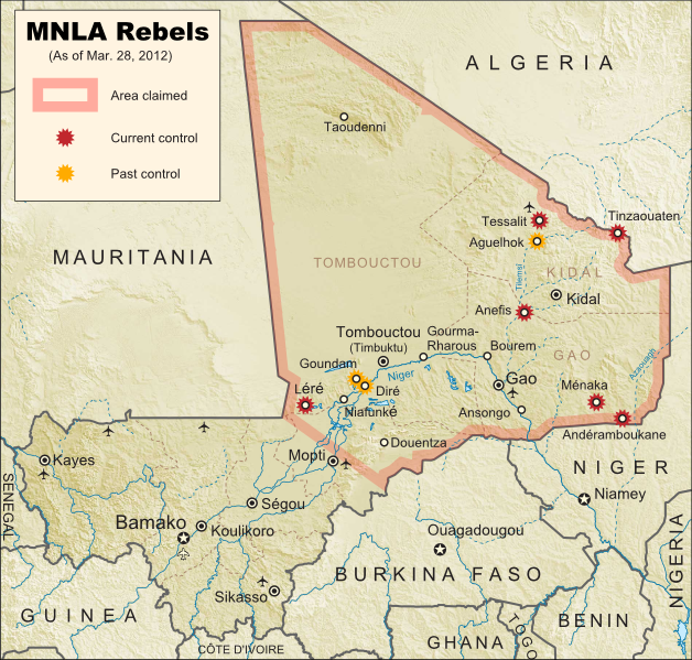
Map of Tuareg rebellion in Northern Mali, showing towns controlled by the MNLA rebel group as of March 31, 2012
Towns captured by the Tuareg-majority MNLA rebel group in Mali. Modified from Wikimedia map by Orionist, incorporating images by Carport and NordNordWest (source). License: CC BY-SA.

Full Story: Mali Divided by Separatist Fighting

Conflict Update
Right on the heels of our last Mali map update, the Tuareg-led rebels of the National Movement for the Liberation of Azawad (MNLA) have made a great deal of further progress, including their biggest victory yet. Yesterday the rebel group captured Kidal, one of the three main cities in northern Mali (the region in which they hope to establish an independent country called Azawad). This time, it was widely reported that the MNLA was working together with Ansar Edine (or “Ansar Dine”), an Islamist group also led by a veteran Tuareg fighter, but which the other rebels had formerly shunned.

Just after overrunning Kidal, the MNLA was reported to have taken the towns of Bourem and Ansongo on either side of Gao, a key city containing the northern headquarters of the Malian military. Malian troops had previously announced their withdrawal from those two towns in order to focus their defense on the city. Now, the Tuareg fighters have entered the city of Gao, and are currently fighting to take the two military bases there. Follow events as they develop on Political Geography Now! To see only stories about this ongoing conflict, use the Mali filter.

Mali Conflict Map: Separatists Gain Ground in North (March 2012)

Country Name: Mali (English, French, Bambara)
Official Name: Republic of Mali (English), République du Mali (French)
News Category: Divided Countries
Summary: The rebellion of Tuaregs and other ethnic groups in northern Mali has continued gaining territory, and now threatens major cities in the north, where the rebels seek to establish an independent country called Azawad. Meanwhile, Malian military leaders upset with their government’s handling of the rebellion have taken over the country in a coup, leading to increased chaos on the country’s suspension from the African Union.

Map of Tuareg rebellion in Northern Mali, showing towns controlled by the MNLA rebel group
Towns captured by the Tuareg-majority MNLA rebel group in Mali. Modified from Wikimedia map by Orionist, incorporating images by Carport and NordNordWest (source). License: CC BY-SA.

Full Story: Mali Divided by Separatist Fighting

Conflict Update
After a month with no territorial gains or losses reported, on March 11 the National Movement for the Liberation of Azawad (MNLA) captured of the town of Tessalit in Mali’s far north. Home to a major military base and an airport, Tessalit was a major prize for the rebels, most of whom come from the traditionally nomadic Tuareg ethnic group. Their push for independence continued two days later with the storming of Diré and Goundam, two towns near the major northern city of Timbuktu, though it is unclear whether those two towns are still occupied by the MNLA.

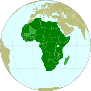
Map of the African Union, marking suspended members Mali and Madagascar
The African Union (green) with suspended members
Mali and Madagascar in lighter green. Modified from
this Wikimedia map (public domain).

An unexpected turn of events came on March 21, when the Malian government fell in a military coup. The leaders of the takeover cited President Amadou Toumani Toure’s ineffectiveness at combating the Tuareg revolt in the north as their reason; ironically however, the chaos caused by the coup has proved beneficial to the rebels, who on March 23 captured the town of Anefis on the road between Gao and Kidal, two of the north’s major cities. The MNLA has boasted that it will soon take those two cities, as well as Timbuktu, and recently it has indeed been reported that Malian troops in Kidal are negotiating a surrender after the city was surrounded by Tuareg militias.

In the confusion, another Tuareg-led rebel group, the Islamist Ancar Dine, has also claimed to control the towns of Tinzaouaten, Tessalit, and Aguelhok, which according to most other sources are actually held by the MNLA. Though the two rebel groups have a share a history of being formed by leaders of former Tuareg rebellions, some local experts doubt that they are actually working together. Meanwhile, the coup in Mali’s capital city of Bamako has resulted in the country’s suspension from the African Union (AU), an important regional organization which includes every country in Africa except for Morocco. Mali is one of only two currently suspended AU states, the other being Magascar, which also experienced a coup d’etat several years ago.

(Note: For updates to the Mali conflict map, follow the Mali label on Political Geography Now.)

Mali Divided by Separatist Fighting (February 2012)

Country Name: Mali (English, French, Bambara)
Official Name: Republic of Mali (English), République du Mali (French)
News Category: Divided Countries
Summary: Several towns in the African country of Mali have fallen out of government control this month, taken over by a separatist group known as the National Movement for the Liberation of Azawad (MNLA). The rebels are led by members of the Tuareg ethnic group, traditionally nomadic inhabitants of the Sahara Desert, who dwell in Mali’s northern regions and have a long history of conflict with the national government.

Towns captured by the MNLA rebel group in Mali. Modified from Wikimedia map by Orionist, incorporating images by Carport and NordNordWest (source). License: CC BY-SA.

(Note: For updates to this map, follow the Mali label on Political Geography Now.)

Full Story
One of the many African states formed based on arbitrary borders from the European colonial era, Mali is divided into two visibly distinct regions which are both geographically and ethnically distinct. The southern area, which hosts the majority of the population, has a tropical climate and is dominated by the Bambara and other West African peoples, while the northern region is located in the Sahara Desert, historically the domain of the Tuareg nomads. Over the last century, there have been at least four separate rebellions led by Tuareg people, many of whom feel their homeland should never have been included in Mali in the first place. Now, the recently formed National Movement for the Liberation of Azawad (MNLA) has begun one more uprising against Mali, with better chances of success than ever before.

Proposed flag of Azawad (image by Orionist; source)

Country Profile: Mali (Wikipedia)

The war began on January 16th of this year, when MNLA forces launched an attack on the town of Ménaka, the next day taking control of that location as well as the towns of Aguelhok and Tessalit, both of which lie in the area bordering the rebels’ bases in the mountains of the Kidal region. On January 18th, the Malian army apparently recaptured all three towns, but the MNLA was not deterred. After another unsuccessful takeover of Aguelhok on January 24th, the revolutionaries finally captured and held onto the towns of Andéramboukane and Léré on the 26th, penetrating unusually far into the south of the country. On February 1st, rebels again captured Ménaka after government forces withdrew from the town, and one week later the MNLA secured the border town of Tinzaouaten, driving their opponents from the Malian military across the border into Algeria. The city of Kidal also saw fighting in February, and the conflict continued throughout the month, though no further territorial gains by the MNLA have been reported in the last three weeks.

Running Summary of News on the Uprising:  “2012 insurgency in the Azawad” (Wikipedia)

Positions of Mali (dark green) and Libya (light green) in
Africa. Modified from this Wikimedia map (public domain).

The MNLA, although composed largely of Tuareg people, has also made a major effort to include Arabs, Songhai, and other peoples of “Azawad” (Northern Mali), where it hopes to establish an independent country. However, not all northerners support the revolt; Tuareg, Arabs, and members of other groups are fighting on both sides of the conflict. The MNLA is much better armed than previous revolutionary groups, partly because many exiled Tuareg rebel leaders have recently returned to Mali from nearby Libya – many of these veteran revolutionaries were employed and armed by the Libyan government, and eventually ended up fighting on both sides of that country’s 2011 civil war (a part of the Arab Spring revolutions). However, this new uprising also has the advantage of being the best organized yet, and of commanding a vastly more effective public relations network than ever before. The Malian government has also accused the rebels of being in league with Al Qaeda in the Islamic Maghreb (AQIM), a local affiliate of the worldwide terrorist organization; however, evidence for this is scant, and many from the MNLA in fact consider AQIM to be among their greatest enemies.

Further Reading: “The Causes of the Uprising in Northern Mali” – Think Africa Press (excellent in-depth background and analysis by a Northern Mali expert)

Sources
2012-1-26. “Tuareg rebels attack fifth town in Mali”. Al Jazeera.
2012-1-31. “Tuareg rebels take Mali town after army pullout”. AFP.
2012-2-2. Stewart, Scott. “Mali Besieged by Fighters Fleeing Libya”. Stratfor Global Intelligence.
2012-2-6. Morgan, Andy. “The Causes of the Uprising in Northern Mali”. Think Africa Press.
2012-2-9. Diallo, Tiemoko & Adama Diarra. “Malian rebels seize key border town, civilians flee”. Reuters.