On the Ground: Gibraltar and the “Brexit” Referendum

This is the first installment of PolGeoNow’s On the Ground, a new series of exclusive photo essays on what political geography looks like in the real world. Whether it’s borders, nationalism, or other geopolitical phenomena, we’ll bring the on-the-ground situations to your screen in vivid detail.

Update 2016-06-24: Gibraltar on Thursday voted in favor of the UK staying in the European Union, by an incredible margin of  96% to 4%. However, the UK as a whole voted to leave the EU, meaning that Gibraltar can expect to get pulled out with it, against the wishes of the Gibraltarians.
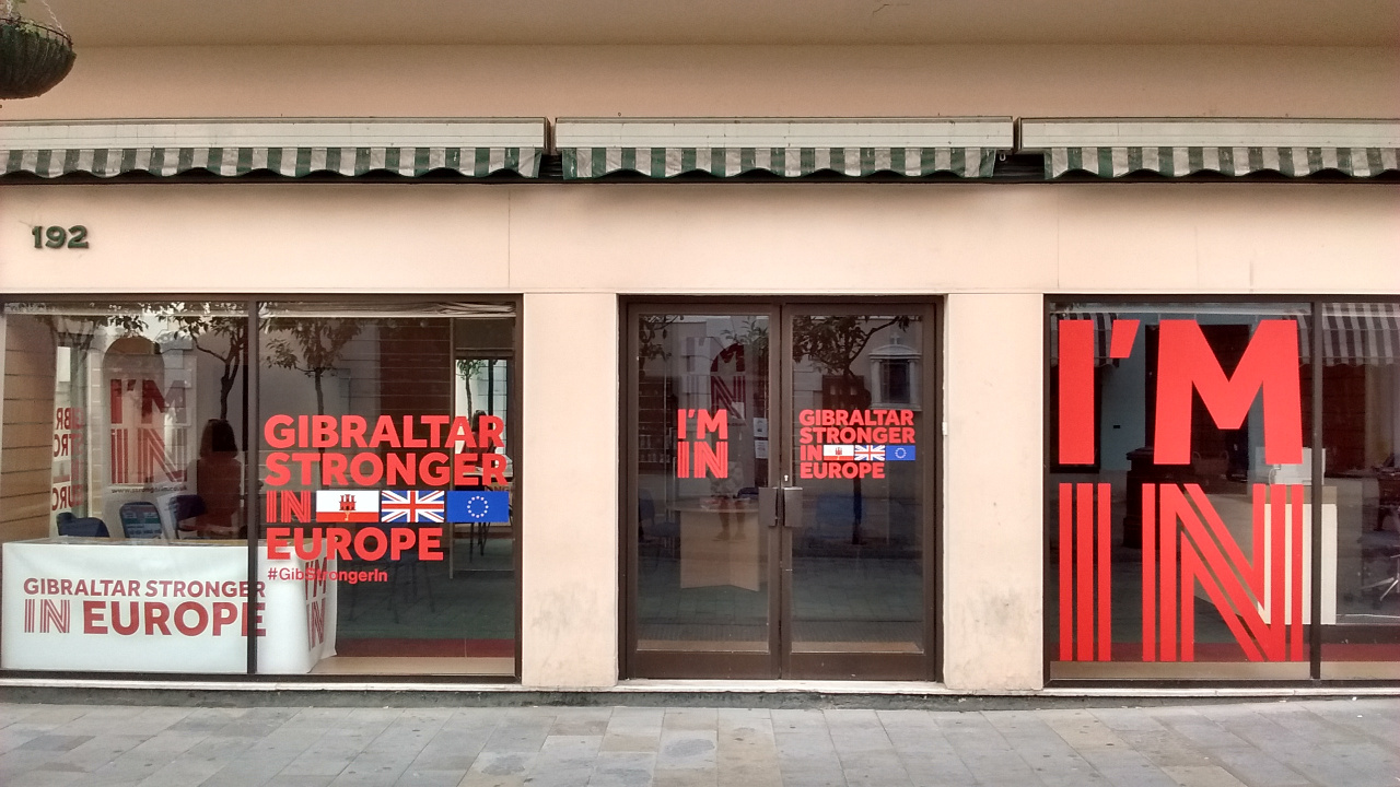
 

Photo of the Gibraltar Stronger in Europe campaign office on the British territory's main street. Gibraltar's population is overwhelmingly against a so-called Brexit, or departure of the UK from the European Union.

Subscribers click here to view this article in the ad-free members area. Not a member yet? Learn about PolGeoNow subscriptions!
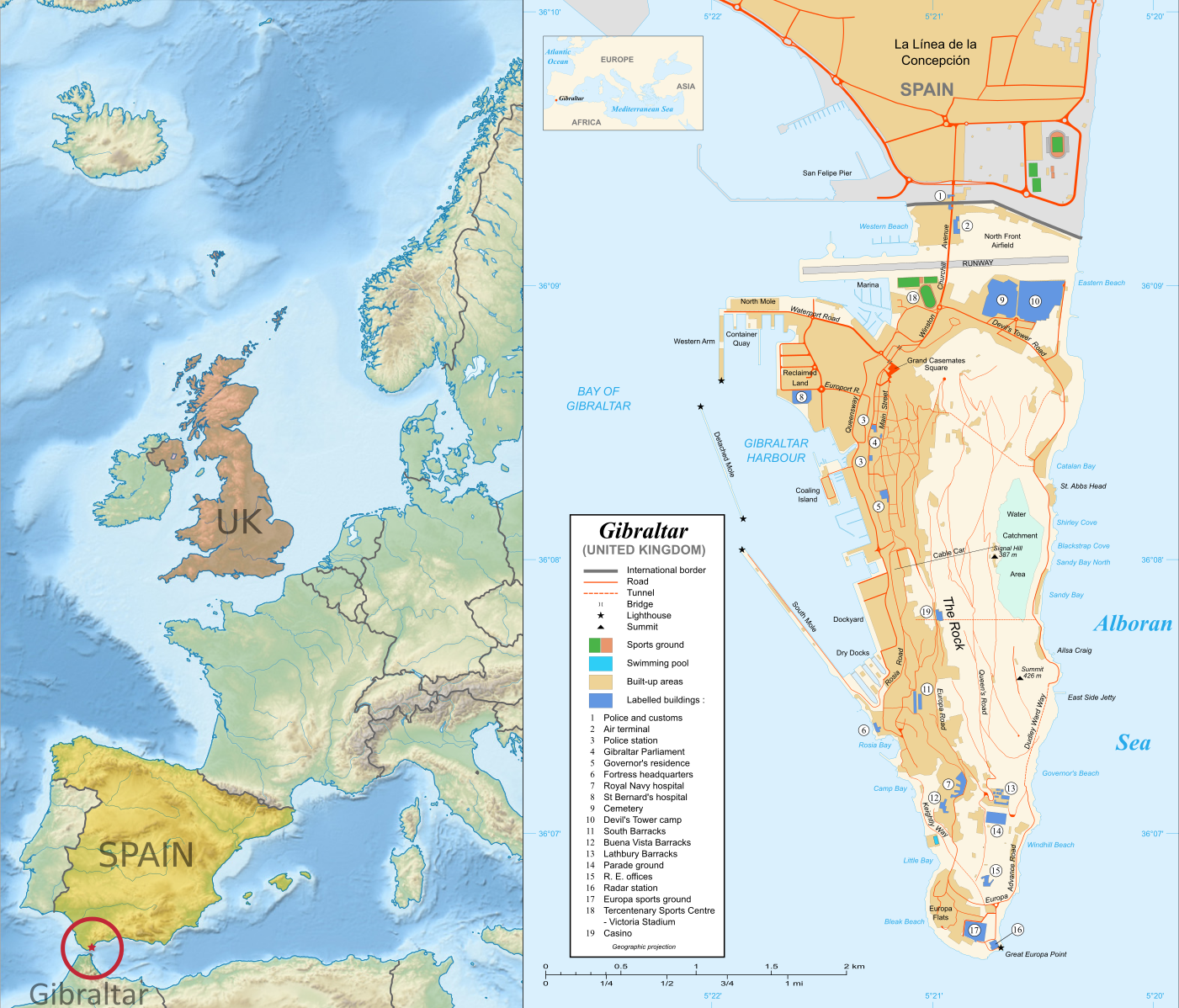
Map of Gibraltar and its location in Europe relative to the UK and Spain
Right: Map of Gibraltar by Eric Gaba (source; CC BY-SA)
Left: Gibraltar’s location in Europe (based on this Wikimedia Commons map by TUBS; CC BY-SA)

Gibraltar prepares to vote on whether UK should leave European Union
Last month, PolGeoNow’s Evan Centanni and Meihsing Kuo visited the small British territory of Gibraltar (pronounced “jih-BRALL-ter”), one month ahead of the UK’s referendum on whether to leave or remain in the European Union (EU).

Gibraltar, a tiny peninsula connected to Spain – and claimed by the Spanish government – is the only British overseas territory that’s part of the EU. It’s also the only external territory whose residents are eligible to vote in the so-called “Brexit” referendum without living in the UK proper. (“Brexit” is an abbreviation for “British exit” from the EU.)
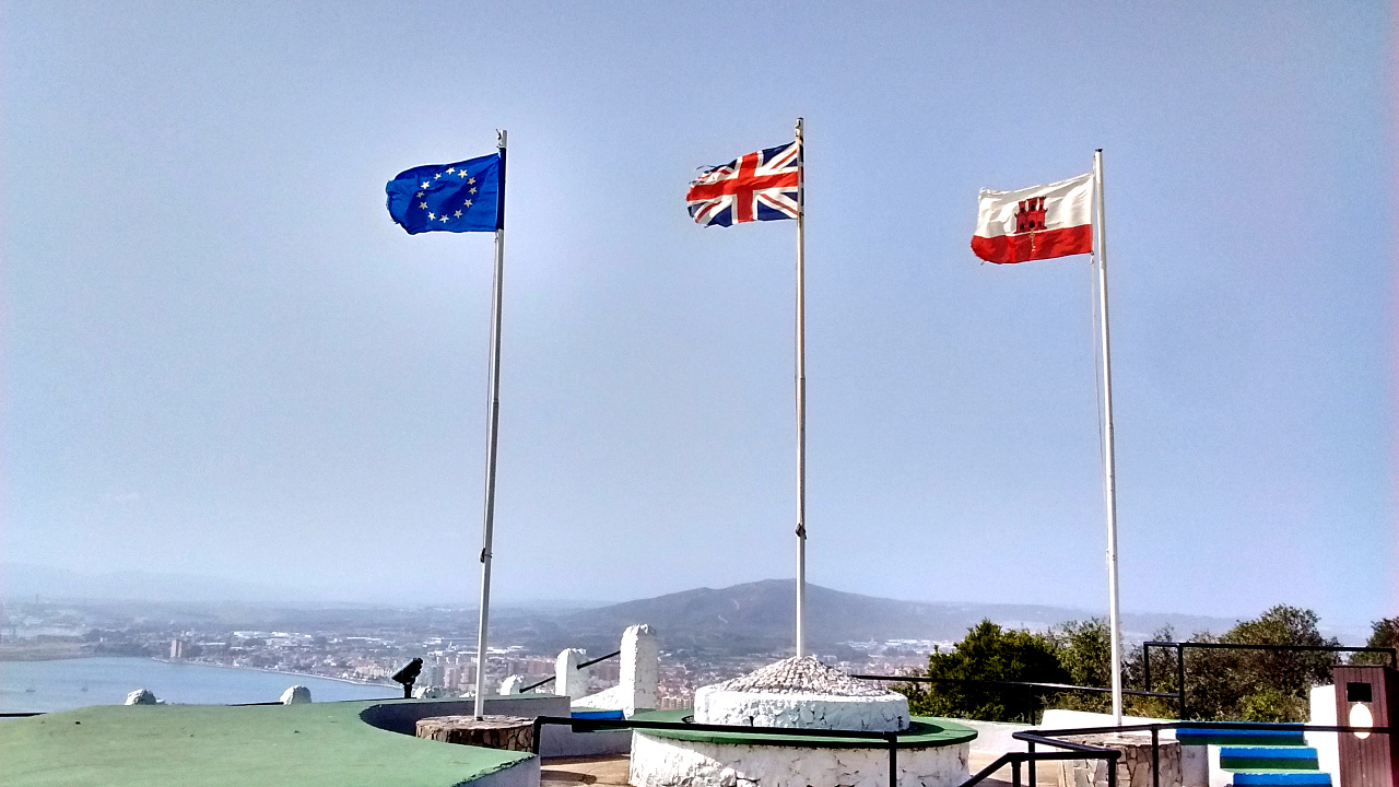
Photo of the European Union (EU), United Kingdom (UK), and Gibraltar flags flying side by side. Gibraltar is the only British territory that's also part of the EU.
Gibraltar flies the European Union flag (left), the flag of the United Kingdom (middle), and its own flag (right)

Gibraltar is a short walk from the Spanish town of La Línea, whose name means “the line” in Spanish – a reference to the line of fortifications Spain built along the border in the 18th Century, when it was still trying to capture the peninsula from Britain by force. (The town’s full name is La Línea de la Concepción, a reference the doctrine of the Immaculate Conception, a central tenet of the Spanish forces’ Roman Catholic religion. Incidentally, most Gibraltarians are also Catholic.)

Because Gibraltar and Spain are both part of the EU, residents of both are free to live or work in the other. Thousands of people live in Spain, where food and rent are cheaper, and commute to work in Gibraltar, where wages and employment are higher. Gibraltar residents also rely on the semi-open border for access to affordable goods from Spain. But that could all come grinding to a halt if the UK decides to leave the union.
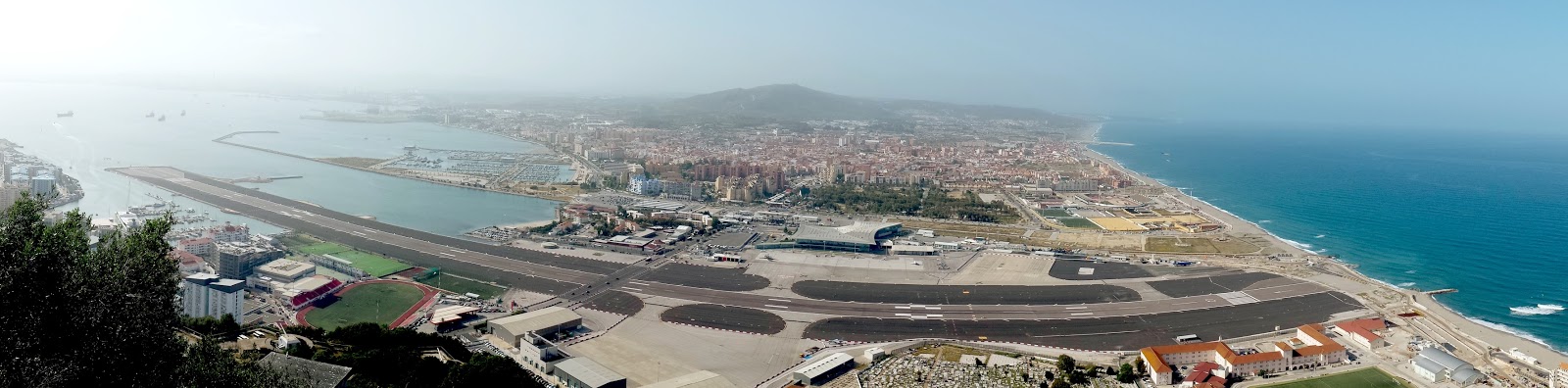
Aerial-style photo of the entire border between La Linea de la Concepcion, Spain, and the British territory of Gibraltar, as seen from atop the Rock of Gibraltar. At front and center is the Gibraltar Airport and runway.
The entire border of Spain (background) and Gibraltar (foreground), as seen from the Rock of Gibraltar. The border runs approximately along the far edge of the airport facilities. Click to see the picture at full size. (Photo by Meihsing Kuo)

Gibraltar is a special EU territory that’s outside the Customs Union and the Schengen Area, so there are still passport and customs checks at the border (though they seemed pretty lax to us). But in pre-EU days, Spain closed the border altogether as a way of protesting British control of the peninsula.

Photo of the border crossing facility between La Linea de la Concepcion, Spain, and the British territory of Gibraltar, including everyday vehicle and foot traffic.
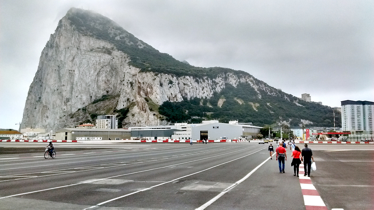
Crossing the border from Spain into Gibraltar. In the background is the Rock of Gibraltar.

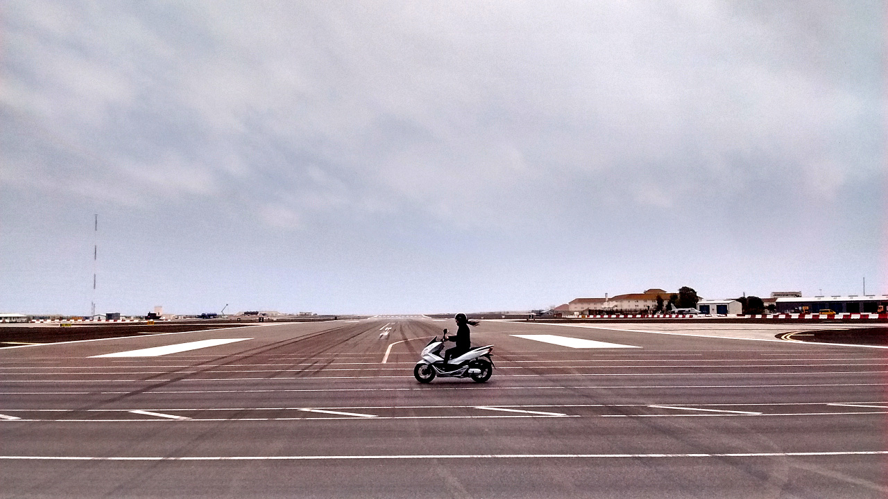
As a funny side-effect of Gibraltar’s position on a tiny peninsula, all traffic across the border has to cross the runway of the Gibraltar airport. There are only five or ten airplane takeoffs and landings each day, but each time there is one, cars and pedestrians have to wait for it to finish before they can go from Spain to Gibraltar or back. A planned traffic bypass is years overdue.

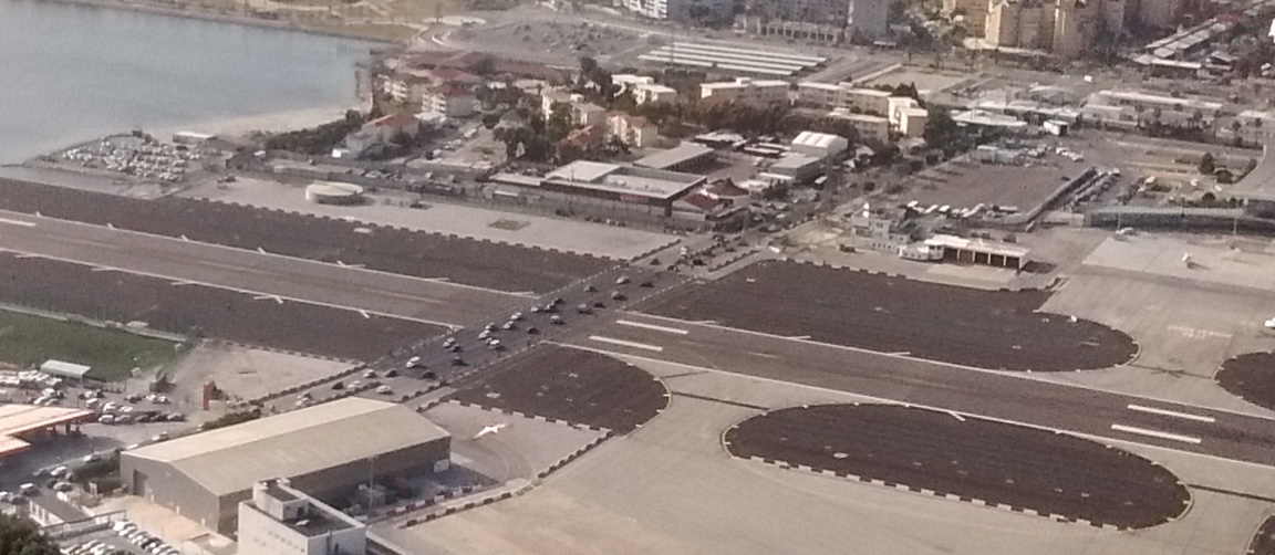
Photo of an airplane landing at the Gibraltar airport, crossing the only road that passes between Spain and the British colony, and temporarily stopping all cross-border traffic.

Photo of cars and other traffic crossing the runway of the Gibraltar airport after having waited for a plane to land. The road crossing the runway is the only land route in or out of the British territory which borders Spain.

Photo of pedestrians and a cyclist crossing the runway of the Gibraltar airport. The road crossing the runway is the only land route in or out of the British territory which borders Spain.

Photo of a motorcycle crossing the runway of the Gibraltar airport. The road crossing the runway is the only land route in or out of the British territory which borders Spain.

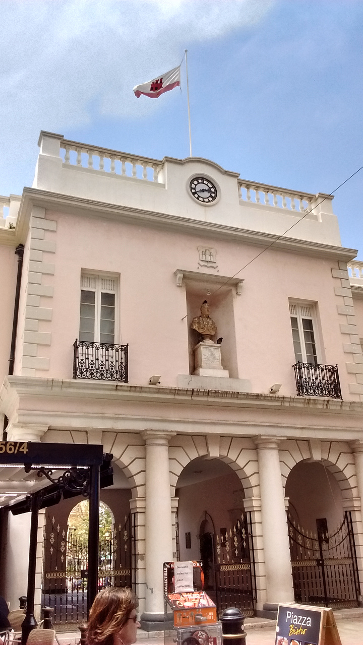
Photo of the Gibraltar Parliament building, headquarters of self-government in the highly-autonomous British territory.
The Gibraltar Parliament building

Unlike British colonies of the past, Gibraltar is almost completely self-governed by its own elected parliament. For internal matters, the Gibraltar parliament doesn’t even legally answer to the British parliament in Westminster. But although Gibraltar’s not considered part of the UK, its land officially belongs to the UK, and it can’t have its own military or international relations. That means if the UK cuts ties with the EU, Gibraltar is along for the ride.
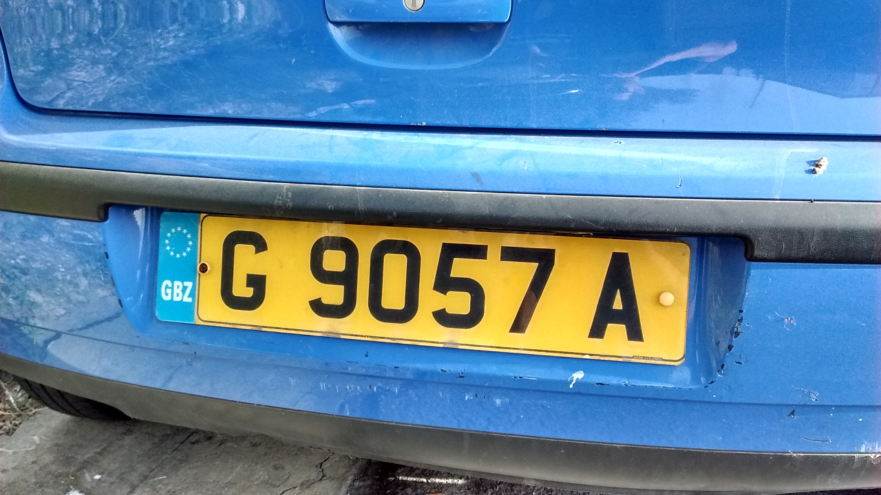
Photo of a yellow vehicle registration plate (license plate) in Gibraltar, showing the pan-European plate design and GBZ country code designation.
Gibraltar vehicle plates have their own country code – GBZ.

Photo of a bring-out-the-vote poster in a window in Gibraltar, posted by the territorial government to remind residents to vote in the upcoming Brexit referendum on whether Britain should leave the European Union (EU)
Gibraltar government promoting voter turnout in the “Brexit” referendum

Gibraltarians are able to vote in EU elections through a special arrangement that treats them as constituents of southwestern England, and the same arrangement will allow them to vote in the “Brexit” referendum. Though the territory’s 23,000 registered voters are just a drop in the bucket compared to the 45 million or so in the UK, this referendum might come right down to the wire, so it’s not out of the question that they could make a difference.

In any case, Gibraltarians want to be heard, even if only as justification to demand help from the UK if they do get pulled out of the EU. Because of the Gibraltar’s heavy dependence on the border, all three of the territory’s political parties are campaigning for the UK to remain in the union. And what about regular voters? A local newspaper poll found that 88% of people who planned to vote supported staying in the EU.
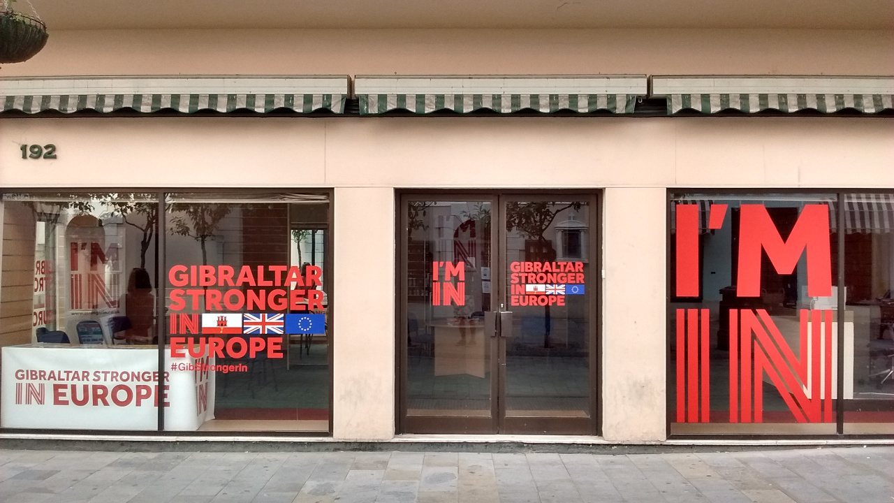
Photo of the Gibraltar Stronger in Europe campaign office on the British territory's main street. Gibraltar's population is overwhelmingly against a so-called Brexit, or departure of the UK from the European Union.
The Gibraltar chapter of Britain’s anti-Brexit “Stronger In” campaign has a prominent office on the town’s main street.

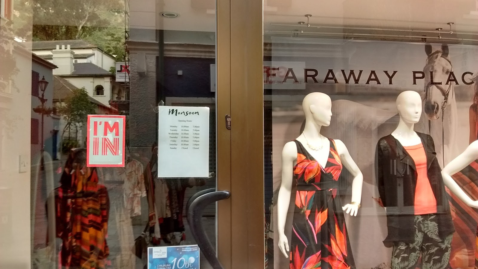
Photo of a shop window in Gibraltar, prominently displaying a sticker that reads I'm In, indicating that the business supports voting for the UK to remain in the European Union (EU) in the upcoming Brexit referendum.
Continued EU membership is uncontroversial in Gibraltar. “I’m In” stickers show many local businesses’ open support of the campaign to vote against leaving the EU.

It’s hard to say exactly what will happen to Gibraltar if the UK does choose to quit the European Union – and that uncertainty is part of what most Gibraltarians are trying to avoid. For now Gibraltar seems content to be a British territory: residents have already twice voted against joining Spain. But if they feel betrayed and abandoned by a UK that wants no part in the EU, could demands for greater autonomy or even independence be around the corner? Only time will tell.

Photos and text by Evan Centanni, except where specified otherwise. All rights reserved.
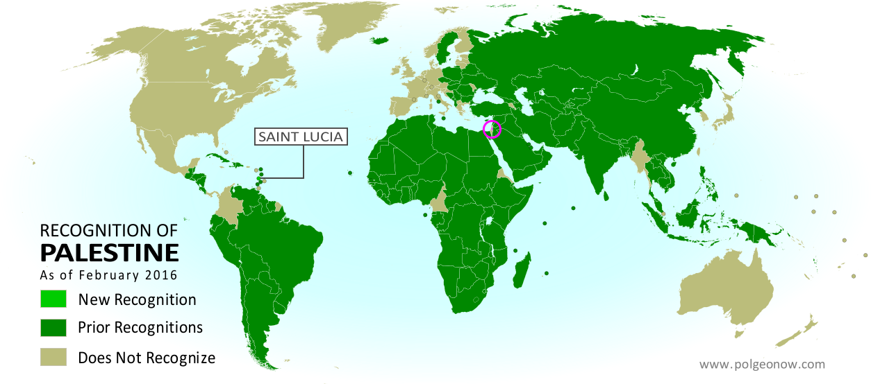
Map: Which Countries Recognize Palestine as Independent in 2016?

(Keep up with changes to Palestine’s situation: view all Palestine updates.)

Map of countries that recognize the State of Palestine as an independent country, updated for February 2016 with recent addition Saint Lucia highlighted
Click to enlarge. Palestine in magenta (circled). Map by Evan Centanni, modified from public domain graphic (source).

Subscribers click here to view this article in the ad-free members area. Not a member yet? Learn about PolGeoNow subscriptions!

Article by Evan Centanni

Disputed Country

The Palestinian Liberation Organization (PLO) declared an independent State of Palestine in 1988, and continues to pursue its recognition as a country today. Though Palestine’s claimed territories are disputed and largely occupied by Israel, it has gathered recognition from more than two-thirds of the world’s countries, and is also treated as a country by the UN General Assembly, where it’s an “Observer State” but not a member.

Flag of Palestine Country Name:  
• Palestine (English)
Filasṭīn (Arabic)
Official Name:  
• State of Palestine (English)
• Dawlat Filasṭin (Arabic)
Capital: 
• Jerusalem (claimed)
Ramallah (administrative)

The number of individual countries recognizing Palestine has grown gradually over the past decades. Last June we reported that 135 U.N. member states (and one observer state) officially recognized Palestine, and since September the number is now 136 (about 70% of all UN members). Palestine is also recognized by the proclaimed government of Western Sahara, another disputed country that’s not formally recognized by the UN.

Saint Lucia Recognizes Palestine

Last September, the small Caribbean island country of Saint Lucia became the latest national government to recognize Palestine as independent. The formal acknowledgement came on September 14, 2015, when the two countries’ UN representatives signed an agreement in New York to establish diplomatic relations.

Saint Lucia is now one of about half the world’s countries whose government recognizes both Palestine and Israel as independent countries. All of the independent Caribbean countries except Cuba recognize Israel, and most also recognize Palestine, with the exception of Jamaica, the Bahamas, Saint Kitts and Nevis, Barbados, and Trinidad and Tobago.

Read More:
Is Palestine Really a Country?
Palestine Recognized as a Country by the UN
Map of Countries Recognizing Kosovo

Vatican City Administration Recognizes Palestine as a Country (map)

(Keep up with changes to Palestine’s situation: view all Palestine updates.)

Map of countries that recognize the State of Palestine as an independent country, updated for June 2015 with recent addition Vatican City (Holy See) highlighted
Click to enlarge: Countries recognizing the State of Palestine in green, with most recent addition highlighted. Palestine in magenta (circled). Map by Evan Centanni, modified from public domain graphic (source).

Subscribers click here to view this article in the ad-free members area. Not a member yet? Subscribe now!

Article by Evan Centanni

Vatican Recognizes Palestine
Last month the Holy See – the official administration of the Roman Catholic Church and government of Vatican City – became the latest national government to recognize Palestine as an independent country. The explicit acknowledgement of Palestine’s statehood came with a treaty signed May 13, 2015, regarding the activities of the Catholic Church within Palestine’s territory. 

In the face of criticism from Israel’s government and other groups, the Vatican played down the significance of the treaty, saying that the Holy See had really recognized Palestine ever since supporting the UN vote on Palestinian’s statehood in 2012. However, official diplomatic recognition usually requires an explicit statement by the country’s government, so the Holy See was presumed not to formally recognize Palestine until now.

Learn More: What’s the difference between Vatican City and the Holy See?

Vatican City is now one of about half the world’s countries whose government recognizes both Palestine and Israel as independent countries. But Palestine is recognized by only a few countries in Europe, and the Holy See is only the fifth European government to recognize since the end of the Cold War. The last was Sweden in October 2014, preceded by Iceland in 2011, Montenegro in 2006, and Bosnia in 1992.

Flag of Palestine Country Name:  
• Palestine (English)
Filasṭīn (Arabic)
Official Name:  
• State of Palestine (English)
• Dawlat Filasṭin (Arabic)
Capital: 
• Jerusalem (claimed)
Ramallah (administrative)

Palestine: Disputed Country
The Palestinian Liberation Organization (PLO) declared independence for Palestine in 1988, and has been seeking international acceptance for the proclaimed country ever since. Though its claimed territories are disputed and largely occupied by Israel, the “State of Palestine” is recognized by more than two-thirds of the world’s countries, and is also treated as a country by the UN General Assembly, where it is an “Observer State” but not a member.

The Holy See also has Observer State status in the UN, making Vatican City and Palestine the only two countries that are acknowledged as independent by the UN, but do not have votes in the General Assembly.

The number of individual countries recognizing Palestine as independent has grown gradually over the past decades. Last year we reported that 135 UN member states officially recognized Palestine (70% of all UN members), and this is still the case today, since Vatican City is not a full UN member. Palestine is also recognized by the proclaimed government of Western Sahara, a fellow disputed country whose independence is not formally recognized by the UN at all.

Related:
Is Palestine Really a Country?
Palestine Recognized as a Country by the U.N.
Map of Countries Recognizing Kosovo

Map: Which Countries Recognize Palestine in 2014?

(Keep up with changes to Palestine’s situation: view all Palestine updates.)

Map of countries that recognize the State of Palestine as an independent country, updated for December 2014 with recent addition Sweden highlighted
Countries recognizing the State of Palestine in green, with most recent addition highlighted. Palestine in magenta (circled). Click to enlarge. Map by Evan Centanni, modified from public domain graphic (source).

Premium members click here to view this article in the ad-free members area. Not a member yet? Subscribe now!

Article by Evan Centanni

Disputed Country
Palestine declared independence in 1988, and its government continues to pursue recognition as a country today. Though its claimed territories are disputed and largely occupied by Israel, the “State of Palestine” has gathered recognition from more than two-thirds of the world’s countries, and is also treated as a country by the U.N. General Assembly, where it is an “Observer State” but not a member.

The number of individual countries recognizing Palestine as independent has grown gradually over the past decades. A year ago we reported that 134 U.N. member states officially recognized Palestine, and as of December 2014 the number is now 135 (70% of all U.N. members). Palestine is also recognized by the proclaimed government of Western Sahara, another disputed country that’s not formally recognized by the U.N.

Flag of Palestine Country Name:  
• Palestine (English)
Filasṭīn (Arabic)
Official Name:  
• State of Palestine (English)
• Dawlat Filasṭin (Arabic)
Capital: 
• Jerusalem (claimed)
Ramallah (administrative)

Sweden’s Recognition of Palestine
Only one new country has endorsed Palestine’s independence in 2014, but it’s a big one. On October 30, Palestine was officially recognized by Sweden, a major European country and and member of the European Union (EU). This is a big deal because most of Western Europe does not recognize Palestine, and of the 50-60 total countries worldwide that don’t recognize, about half are in Europe.

Palestinian Recognition in Europe
Sweden is the first country to begin recognizing Palestine after becoming a member of of the EU, an organization that tends to take a centrist stance on the Israeli-Palestinian conflict. In recent months, legislatures in France, Spain, Ireland, and the UK have also voted in support of recognizing Palestine, but so far none of their governments has followed through with official recognition.

However, Sweden isn’t the only EU country that endorses Palestine’s claimed independence: Malta, Czechoslovakia, Cyprus, Hungary, Romania, Bulgaria, and Poland all recognized it in 1988, before they became EU members.* Russia, Belarus, Ukraine, Serbia, and Albania also retain recognition from 1988, but are not members of the EU. And yet, neither is Sweden the only European country to recognize Palestine since the end of the Cold War. Bosnia recognized in 1992, Montenegro in 2006, and Iceland in 2011. 

*After the breakup of Czechoslovakia, the Czech Republic and Slovakia inherited their recognition of Palestine, though the current Czech government does its best to ignore that fact, having become a very close ally of Israel. Cyprus, on the other hand, has recently reaffirmed its original position on Palestinian independence. 

Related Articles:
Is Palestine Really a Country?
Palestine Recognized as a Country by the U.N.
Map of Countries Recognizing Kosovo

Map: “Eurasian Union” Gets New Member

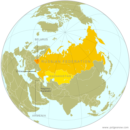
Map of the Eurasian Economic Union (EEU), also known as the Eurasian Union. Includes new member Armenia, as well as prior members Russia, Belarus, and Kazakhstan, and disputed territories Crimea and Nagorno-Karabakh.
The Eurasian Economic Union’s four member countries, plus disputed territories that might be officially or unofficially included. Map by Evan Centanni, starting from this map by Keverich2. License: CC BY-SA

Premium members click here to view this article in the ad-free members area. Not a member yet? Subscribe now!

Article by Evan Centanni

Armenia Joins Eurasian Economic Union
The Eurasian Economic Union (EEU), widely seen as a Russian-led answer to the European Union (EU), just welcomed its fourth member country. Armenia, a small former Soviet republic in the Caucasus region of Western Asia, joined Russia, Belarus, and Kazakhstan in the trade bloc after signing the organization’s founding treaty last Friday, October 10. However, the EEU, which will unite the four member countries’ economies into a single cooperatively-managed entity, doesn’t officially go into effect until New Year’s Day (January 1, 2015).

Flag of ArmeniaCountry Name:  
• Armenia (English)
• Hayastan (Armenian) 
Official Name:  
• Republic of Armenia (English) 
• Hayastani Hanrapetutyun (Armenian)
Capital: Yerevan

What is the “Eurasian Union”?
Though sometimes called just the “Eurasian Union”, the EEU is for now strictly economic in nature. Russia has shown interest in eventually expanding it into a political union to match the EU – however, that path is unpopular with fellow founding member Kazakhstan, which sees political union as a threat to the independence it gained after the breakup of the Soviet Union in 1991.

The economic union hopes to increase trade and lower prices by establishing a “Single Economic Space,” where goods, services, money, and people can all move freely from country to country without the obstruction of borders or import taxes. Industrial development, agriculture, and transportation will also be managed cooperatively, and people from one country will be able to live and work in any of the other countries without a visa.

What’s the difference: Eurasian Economic Union, EURASEC, and the Customs Union
Though the EEU has not yet gone into effect, Russia, Belarus, and Kazakhstan are already united in an organization called “the Customs Union“. This union partially combines the countries’ economies by replacing customs checks along their mutual borders with a unified customs policy for all imports coming into the three-country bloc. Armenia is apparently still not a member of the Customs Union, though the issue will presumably become moot on January 1, when the Customs Union is replaced with the new EEU.

The EEU is not the same thing as the Eurasian Economic Community (EURASEC), an earlier attempt at economic integration among former Soviet countries. EURASEC includes more countries than the EEU, but its members’ economies are not closely unified. The EEU in many ways grew out of the broader organization, and the member countries have agreed to dissolve EURASEC once the EEU comes into force on January 1, 2015.

Armenia’s Path to Membership
Armenia had originally sought to join the Customs Union this past spring, in advance of the EEU treaty coming into effect. However, its membership has been repeatedly delayed. Many suspect this was because of disagreements with the current Customs Union member countries over the Nagorno-Karabakh Republic, an Armenian-backed breakaway state that the rest of the world considers to be part of the neighboring ex-Soviet country of Azerbaijan. Even Armenia doesn’t officially recognize Nagorno-Karabakh, which declared independence in 1991, but makes no secret of being the breakaway state’s main supporter.

Map of the breakaway Nagorno-Karabakh Republic relative to Armenia and Azerbaijan
The breakaway Nagorno-Karabakh Republic (NKR)
Orange: Former NK Autonomous region in USSR
White: Current NKR territorial control
(public domain map by VartanM and Kmusser; source)

Because Armenia doesn’t maintain any border checks along its boundary with Nagorno-Karabakh, questions have been raised about whether the disputed territory will become an unofficial part of the EEU along with Armenia. With the other EEU members insisting Nagorno-Karabakh can’t be part of the union, and Armenia insisting it won’t set up border checks, it’s unclear how this issue will be resolved.

Meanwhile, another disputed territory will almost certainly be treated as part of the EEU, and officially at that. Crimea, recognized by the rest of the world as part of Ukraine, came under Russian control after a hostile takeover earlier this year. Since Russia, the most powerful member of the new EEU, considers Crimea a legitimate part of its territory, it seems unlikely the region will be excluded in any way from the new economic union.

Graphic of the Armenian flag is in the public domain (source).

Palestine: West Bank and Gaza Reunited Under Transitional Government

(Keep up with changes to Palestine’s situation: view all Palestine updates.)

Map of the State of Palestine in the West Bank and Gaza Strip, including both its claimed borders (the Green Line) and zones of actual control (Areas A, B, and C from the Oslo Accords)
Control zones based on the Oslo Accords. Area A: Palestinian control; Area B: mixed Israeli-Palestinian control; Area C: full Israeli control. Map by Evan Centanni (sources: Natural Earth, B’Tselem, U.N. OCHA oPt).

Premium members click here to view this article in the ad-free members area. Not a member yet? Subscribe now!

By Evan Centanni

Unity Government
The partially-unrecognized State of Palestine is not only divided between Palestinian and Israel control – even the Palestinian-administered areas have been governed separately for several years now. However, this month rival parties Hamas and Fatah have finally come together to reunite the West Bank and Gaza Strip under a single Palestinian government.

Divided Country
The rift in control opened up in 2007, after religious militant group Hamas won a majority of seats in the 2006 Palestinian legislative elections. Hamas and Fatah, the current ruling party at the time, failed to form a stable unity government then, and the conflict between them escalated into a short civil war in the Gaza Strip. 

See Also: Is Palestine Really a Country?

The fighting ended with Hamas expelling Fatah’s administration from Gaza, while Fatah in turn refused to seat Hamas members to the government in Ramallah. This standoff has persisted for nearly seven years, with the West Bank and Gaza controlled separately by the two rival parties. Though both parties supported Palestine’s successful bid for recognition in the UN, the two regions have been administered completely separately since 2007.

Flag of the State of Palestine Country Name:  
• Palestine (English)
Filasṭīn (Arabic)
Official Name:  
• State of Palestine (English)
• Dawlat Filasṭin (Arabic)
Capital: 
• Jerusalem (claimed)
Ramallah (administrative)

Reunification
One week ago, Hamas and Fatah finally came together to form a Palestinian Authority (PA) government that includes both parties. This new administration will have jurisdiction over both the Gaza Strip and Palestinian-controlled areas of the West Bank, making it responsible for domestic affairs all across the claimed State of Palestine. Foreign relations (and relations with Israel) are handled instead by the Palestinian Liberation Organization (PLO), which has been around since before the PA was created in the 1990s by the Oslo Accords.

The current agreement also does not cover whether PA security forces will be allowed into Gaza, whose security has been handled directly by Hamas since 2007. So for the time being, the two areas may remain separate in at least that regard.

Palestine’s new unity administration is facing strong opposition from the Israeli government (which refuses to negotiate with Hamas), but has gained acceptance by much of the world. The UN, the European Union (EU), and China have all signaled their willingness to work with the new PA administration. Even the US has come on board, despite having rejected Hamas’s 2006 election victory. Because of its hardline ideology and ongoing violence against Israel, Hamas is classified as a terrorist organization by the US government, as well as by the EU.

Joining Treaties
These events come on the tail of another development in Palestine’s political status: its entry into 15 international treaties this April. The action was taken by Mahmoud Abbas, who serves as both the President of Palestine and chairman of the PLO. Palestine’s applications to these treaties have already been accepted by the UN (which considers Palestine to be a non-member “Observer State” like Vatican City), and most of them were set to go into effect in May.

Related:
Is Palestine Really a Country?
Which Countries Recognize Palestine as Independent?
Palestine Recognized as a Country by the UN

Flag of the State of Palestine is in the public domain (source).

Mayotte Enters European Union

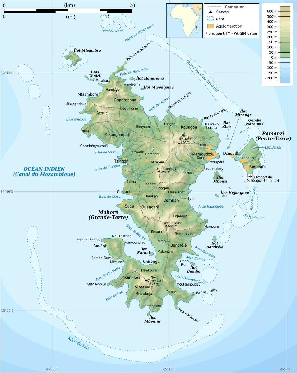
“Outermost regions” are officially part of the European Union; “overseas countries and territories” are not part of the EU itself, but have special relations with it because of their connections to member countries. New outermost region Mayotte is located in southeastern Africa. Map from Wikimedia Commons © Alexrk2 (CC BY-SA)

Premium members click here to view this article in the ad-free members area. Not a member yet? Subscribe now!

Article by Evan Centanni

EU Expands to Include Mayotte
You probably heard about Croatia joining the European Union last year, but did you know the EU expanded further this year…in Africa? The French overseas department of Mayotte, a group of islands in the Indian Ocean northwest of Madagascar, became officially part of the EU on January 1.

Mayotte’s entrance into the European Union is the result of it becoming an “overseas department” of France in March 2011. An overseas department is considered to be fully part of France, just like any other of the country’s departments (a governmental unit similar to a province or county). This means that the people are represented in the French legislature and can vote in both French and European Union elections.

Topographic map of Mayotte, an Indian Ocean island group which is part of France, and which became officially part of the European Union as well on January 1, 2014
Map of Mayotte from Wikimedia Commons © Rémi Kaupp, with elements by Sting (CC BY-SA)

A Series of Referendums
Mayotte became a French colony in 1841, after centuries of rule by East African kingdoms. Part of the Comoro Islands, an archipelago located between Madagascar and mainland Africa, the people of Mayotte were allowed a vote on the question of independence in 1974.

Independence proved very popular on the rest of the Comoro Islands, which soon became the independent Union of the Comoros (still one of the world’s nearly 200 independent countries today). Mayotte itself, however, voted against it. The majority of its people preferred to remain a French territory, and reaffirmed this with a vote of 99% against joining the independent Comoros in 1976. (The Comoros still claim Mayotte as their own, with a 1976 UN Security Council resolution in their support failing after a rare French veto).

At that time, Mayotte was an overseas territory belonging to France, but not considered part of the country itself. However, in 2000 the islands voted to enter a ten-year transition period on the way to joining France proper as an overseas department. From 2001 to 2011, Mayotte was a “departmental collectivity”, neither a normal territory nor an actual department yet. A final referendum in 2009 confirmed that it would become an overseas department in 2011.

Unofficial flag of Mayotte, used locally Name:  
• Mayotte (English, French)
Full Name:  
• Department of Mayotte (English)
• Département de Mayotte (French)
Claimants: France, Comoros
Actual Control: France
Administrative Status: Integral part of France (overseas department)
Capital: Mamoudzou
Demonym: Mahoran

Though becoming part of the EU was an expected outcome of gaining department status, Mayotte’s entry into the organization was not set to take effect until Jan. 1, 2014. The occasion of Mayotte’s entry into the EU was marked by a special visit from the flagship of the European Union Naval Force.

“Outermost Region”
Within the European Union Mayotte is now classified as an “outermost region”. This means that it’s subject to most EU laws, but may be eligible for some exceptions because of practical issues related to not actually being in Europe. For example, other French outermost regions use the euro as their currency, but don’t collect EU value-added tax (VAT) and maintain separate border controls. Mayotte is now one of two EU outermost regions located in the Indian Ocean, the other being fellow overseas department Réunion.

Graphic of the locally-used flag of Mayotte is in the public domain (source).

Crimea Joins Russia, Gives Up Independence, Becomes Disputed Territory

Premium members click here to view this article in the ad-free members area. Not a member yet? Subscribe now!

Map of the claimed Republic of Crimea, which briefly declared independence from Ukraine on Mar. 17 before being annexed by Russia
The claimed Republic of Crimea which has now joined Russia (click to see full-sized map). By Evan Centanni, based on this blank map.

By Evan Centanni

Russia Annexes Crimea
The Crimean peninsula, which declared independence from Ukraine ten days ago as the Republic of Crimea, has now been absorbed into Russia. This was part of the plan all along – the claimed Republic of Crimea had requested to join Russia at the same time that it declared independence.

Related: Complete Map of Locations Seized by Russia in Crimea (Premium)

Once Russia had recognized Crimea as an independent country, Russian president Vladimir Putin then argued all that was necessary for his country to absorb the region was a treaty between the two supposedly sovereign states. The unification treaty between Crimea and Russia was signed on Mar. 18, the day after the peninsula’s declaration of independence. The treaty went into full effect on Mar. 21 after it was ratified by both houses of the Russian parliament and formally signed into law by Putin.

See Also: Crimea Declares Independence: Is It Really a Country? 

Geographical Implications

Flag of Crimea Territory Name:  
• Crimea (English)
Krym (Russian, Ukrainian)
Qırım (Crimean Tatar)
Claimants: 
• Ukraine
• Russia
Actual Control: Russia
Status: Federal subject of Russia (Republic of Crimea)/federal city (Sevastopol)
Capital: Simferopol/Sevastopol

Crimea’s annexation by Russia brings about several simultaneous changes to the world’s political geography situation:

Besides those country-level changes, there has also been an adjustment to the subnational administrative status of Crimea. Ukraine’s Autonomous Republic of Crimea and the special municipality of Sevastopol, which united to claim independence as the Republic of Crimea, have now been separated again as divisions within the Russian Federation. The former Autonomous Republic of Crimea is now the Republic of Crimea, a federal subject of Russia, and Sevastopol is a “city of federal significance” (also a type of federal subject within the Russian Federation).

Transitioning Between Two Countries
Russia’s annexation of Crimea may look complete on paper, but changing the whole region from Ukrainian to Russian administration is going to be a major logistical headache. In addition to the issues of distributing Russian citizenship to all Crimeans and figuring out what to do with members of the Ukrainian military who are stationed there, infrastructure will be a major issue.

Crimea has no land link to the rest of Russia, so new bridges and pipelines will need to be built if the region isn’t going to remain heavily dependent on Ukraine. There will also be a major stir-up to the communications system as telephone area codes are completely replaced to fit into Russia’s system. An extra digit will also need to be added to postal codes, and clocks will be permanently set two hours forward this Sunday to switch to the same time zone as Moscow.
 

Map of Russian seizures and military actions in the Crimea region which it recently annexed from Ukraine.

Also check out our premium map report: 
Complete Map of Locations of Russian Seizures or Attacks in Crimea

More Related Articles:
Ukraine Crisis Overview Map: Occupations, Autonomy, & Invasion (Premium)
How Sharply Divided is Ukraine, Really? Honest Maps of Language and Elections

Graphic of the Crimean flag  is in the public domain (source).

Premium Map Report: Russian Control of Crimea

Map of Russian seizures and military actions in the Crimea region which it recently annexed from Ukraine.

Download PDF
buy

(Subscribe via Paypal)

After a month of low-level conflict, Russian military control of Crimea appears to be nearly complete. Here’s a complete map – to the best of our knowledge – of all locations of Russian seizures and other military actions inside and outside of the Crimea region. This map and article are exclusive premium content, available only to members and for individual purchase. Buy now (US$4.99).

Premium article includes:

  • Exclusive map of Russian seizure and attack locations inside and outside of Crimea
  • Guide to all locations on the map, with brief summary of what has happened at each
  • In-line links to sources of information

Members click here to proceed to article and map

Not a member yet? Subscribe Now!

Map: Peru & Chile’s Sea Dispute Settled in Court

Two weeks ago, the International Court of Justice released a long-awaited ruling on Peru and Chile’s disputed maritime boundary. Many headlines claimed that Peru “won” the case, but in fact it was not a full victory for either country. Below is our detailed map of Peru and Chile’s seas and of the dispute, followed by an easy-to-understand summary of the case. 

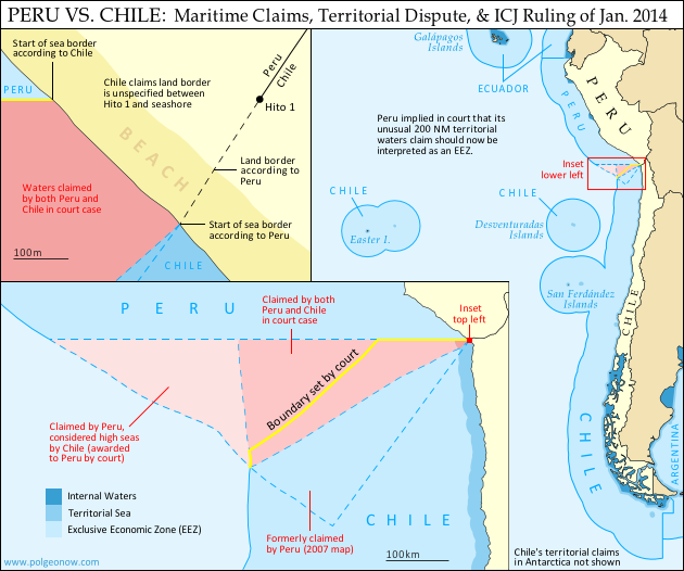
Map of Chile and Peru's territorial waters and exclusive economic zones (EEZ), plus the details of their territorial dispute at sea and disagreement of the land border. Shows the results of the Jan. 27, 2014 ruling by the International Court of Justice (ICJ) settling the dispute.
Map by Evan Centanni (country coastlines and land borders from Natural Earth)

Premium members click here to view this article in the ad-free members area. Not a member yet? Subscribe now!

Article by Evan Centanni


Disputed Territory
Chile and Peru have just settled a decades-long dispute over the location of their maritime boundary (the border between their sea zones). A large wedge of sea off the countries’ coast was claimed by both sides, in part because of its high value for the fishing industry. In 2008, Peru took Chile to court over the dispute. Their disagreements would be resolved by the International Court of Justice (ICJ), a United Nations body in the Hague founded for the purpose of settling differences between U.N. member countries.

Peruvian and Chilean Waters
The international Law of the Sea entitles every coastal state to extend its territory out to 12 nautical miles (NM) from the shore, making these “territorial waters” fully part of the country but requiring that foreign ship traffic be allowed to pass through. The law also allows the country to regulate economic activity out to a distance of 200 NM, within what is called an “exclusive economic zone” (EEZ). Lakes, rivers, and bays (as well as coastal areas hemmed in by islands) are known as “internal waters,” where the country has absolute authority just like on its land territory.

Flag of PeruCountry Name:  
• Peru (English)
• Perú (Spanish)
• Piruw (Quechua, Aymara)
Official Name:  
• Republic of Peru (English)
• República del Perú (Spanish)
Piruw Ripuwlika (Quechua)
Piruw Suyu (Aymara)
Capital: Lima

As a country with an unusually long coastline and possession of several offshore islands, Chile has a long strip of territorial waters and a huge EEZ. But Peru is a bit of a special case: it never ratified the U.N. Convention on the Law of the Sea (UNCLOS), and instead of an EEZ proper, it claims something called a “maritime domain” out to a distance of 200 NM.

Because the Peruvian constitution claims “sovereignty” over this domain, it has always been interpreted as equivalent to other countries’ 12 NM territorial waters. However, during the court case against Chile, Peru’s government declared that its declaration of the maritime domain “is applied in a manner consistent with the maritime zones” in the UNCLOS.* This implies that Peru’s “maritime domain” is now to be considered equivalent to an EEZ rather than to territorial waters, thus curtailing any potential accusations of clearly excessive territorial claims by Peru.

*Source: ICJ judgement, p.61

The Dispute
Since the dispute began some decades ago, Chile claimed that the boundary between the two countries extended due west from the end of the land border. To Chile this meant that it could it extend its own EEZ out to 200 NM directly west from its northernmost coast, but also that the line would keep going from there, cutting off any part of Peru’s maritime domain that might wrap around the outside of Chile’s (the Chilean government noted that Chile itself had made a similar concession on its sea border with Argentina). This is not one of the recommended ways of drawing a boundary under the UNCLOS, but that would all be moot if, as Chile claimed, the two countries had already agreed to it by treaty.

Peru felt differently. It argued that the treaties cited by Chile never explicitly specified a border, and that it therefore was still entitled to negotiate one from scratch. Because Peru’s coast is oriented at an angle to Chile’s, drawing a straight line west would give Chile quite a bit of sea that was actually closer to Peru. So in an official government map from 2007, Peru instead showed the boundary running southwest at an angle of more than 50 degrees from Chile’s line.

In court however, Peru made a more modest claim, choosing an “equidistant line” as recommended in the UNCLOS. This meant carefully calculating a path for which every point would be exactly the same distance from the closest parts of the respective Peruvian and Chilean coasts. The result was a not-quite-straight line running southwest at an angle of about 30 degrees from Chile’s border claim. The area between these two lines would become the officially defined disputed zone. Another large area west of this chunk was within 200 NM of Peru’s coast, but beyond 200 NM from Chile. This zone was claimed by Peru but considered by Chile to be neutral “high seas” (a.k.a. international waters).

But where do the lines start?
In fact, Chile and Peru were not even able to agree on exactly where the maritime boundary should start. The land border between the two countries had been agreed upon in the 1929 Treaty of Lima, and precisely marked on the ground with actual physical pillars. However, the last of the pillars was not right on the shore. Known as Hito 1 (Spanish for “Marker 1”), it was placed on dry land a bit inward from the beach, to ensure that it wouldn’t be washed away.

Peru argued that the border continued, in principle, in a slight curve southwest from Hito 1, following the same circular arc that was used to place the last several border pillars. The treaty apparently wasn’t drafted with this extreme degree of accuracy in mind, and was worded in a way that suggested Hito 1 and the shoreline were the same thing. Chile used this to argue that the sea boundary should be measured along a line drawn from the pillar itself (but not starting until the line reached the seashore), and not from a point to the southwest as Peru claimed. This was taken by many to mean that Chile claimed a land border continuing west from the pillar, but in court Chile’s lawyers argued that there simply was no legally defined land boundary beyond Hito 1.

Flag of ChileCountry Name:  
• Chile (English, Spanish)
Official Name:  
• Republic of Chile (English)
• República de Chile (Spanish)
Capital: Santiago

The Judgement
After years of waiting and over a year of deliberation, the court finally released its ruling on January 27, 2014. Media headlines declared the judgement a “win” for Peru, but in fact it was a complex compromise arrived at through a step-by-step examination of each country’s claims.

The Starting Point and Land Border
The court first needed to decide where the maritime boundary should start. Although Peru argued that it was impossible for a land border to just end without reaching the coastline, the court found that before the dispute began, the two countries had consistently used Hito 1 to define where their respective waters met. This was a small win for Chile, meaning that the maritime boundaary must indeed be drawn from the marker itself rather than from the end of an arc as claimed by Peru.

However, defining the land border itself was not on the court’s agenda, so the disagreement over its course technically remains standing. The court noted that the land border does not necessarily have to end at the same place the sea border begins, meaning that Peru’s claimed land border extension could still be valid even now that it’s irrelevant to the course of the sea boundary.

The Course of the Sea Border
To examine the history of Peru and Chile’s claims, the court examined a series of declarations and treaties published by the two countries in the 1940s and 1950s. It found that both countries had indeed declared jurisdiction out to 200 NM, but that they initially didn’t have any particular border in mind. Instead, their early declarations were intended to protect their waters from foreign whaling and other exploitation, not from each other.

With each treaty they increasingly implied that there was a border running straight west from the coast, but never seemed to say it explicitly. It seemed that perhaps an informal agreement had been made and never put on paper. However, the last treaty referred clearly enough to a straight-west boundary that the court decided it was a done deal. The maritime boundary between Chile and Peru would be line running straight west from Hito 1 – a win for Chile.

But wait – it wasn’t as simple as that. Although the court agreed that Chile and Peru had fixed their straight-west border by treaty, it argued that they had never intended for it to run all the way out to 200 NM or beyond. The agreements referring to the border were only concerned with defining where local fishing boats were allowed to cast their nets, and back then these small boats wouldn’t have ventured out past about 80 NM. The court’s decision, then, was that the boundary should run straight west only to a point 80 NM from the shore – beyond that, there was no line legally agreed upon by treaty.

Beyond 80 NM, the court ruled that Peru indeed had the right to a boundary calculated from an equidistant line out to the farthest point within 200 NM of both countries’ coasts. But since this line started from the end of the 80 NM straight-west line, it ended up quite a bit farther north from Peru’s claimed boundary, giving Chile nearly half of the disputed zone. However, it was still seen as a substantial victory for Peru, since Chile had been seen as controlling the entire zone up until then.

The court also ruled that Peru was indeed entitled to any area of sea within 200 NM of its own coast but beyond 200 NM from Chile. This means that the area previously considered high seas by Chile will indeed become part of Peru’s maritime domain, and even after drawing the equidistant line, a bit of this zone still wraps around the outside of Chile’s EEZ, adding one more segment to the maritime boundary between the two countries.

Dispute Resolved
Though the course of the land border may remain a small sticking point, the sea dispute between Peru and Chile has now been settled (that is, unless the countries argue over the exact coordinates of the line, which were not explicitly named by the court). The ICJ’s ruling is binding, and both Chile and Peru have agreed to respect the court’s decision. Peru’s president Ollanta Humala said he was “pleased” with the ruling, and that he would act quickly to ensure its implementation. President Michelle Bachelet of Chile, on the other hand, called it a “painfull loss,” even while promising to “gradually” implement it.

Full Text: ICJ Judgement of 27 January 2014 – Maritime Dispute (Peru v. Chile)

Related: Map of the Falkland Islands’ Disputed Seas (Argentina vs. U.K.)

Graphics of the Peruvian flag (source) and the Chilean flag (source) are in the public domain.