Map: Palestine Recognized by Two More Countries (134/193)

(Keep up with changes to Palestine’s situation: view all Palestine updates.)

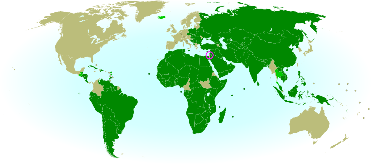
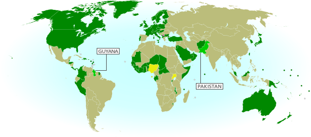
Map of countries that recognize the State of Palestine as an independent country, updated for November 2013 with recent additions Haiti and South Sudan highlighted
Countries recognizing the State of Palestine in green, with most recent additions highlighted. Palestine in magenta (circled). Click to enlarge. Map by Evan Centanni, modified from public domain graphic (source).

By Evan Centanni

List Grows By Two
After being recognized as an Observer State by the U.N. last year to the protest of Israel, the U.S., and other Western countries, the State of Palestine is slowly continuing to receive diplomatic recognition from individual U.N. members. Last May we reported that 132 U.N. member states had officially recognized Palestine, and now the list has grown to 134 (69% of the world body’s total membership). Palestine is also recognized by the proclaimed government of disputed Western Sahara, which is not a member of the U.N.

Flag of Palestine Country Name:  
• Palestine (English)
Filasṭīn (Arabic)
Official Name:  
• State of Palestine (English)
• Dawlat Filasṭin (Arabic)
Capital: 
• Jerusalem (claimed)
Ramallah (administrative)

New Recognition
The most recent country to recognize Palestine as independent is the Caribbean nation of Haiti, which did so near the end of this past September. An official ceremony was held for Haiti’s recognition at U.N. headquarters in New York, in which both Haiti and Caribbean neighbor Grenada signed agreements to establish diplomatic relations with the State of Palestine. However, Grenada has already been on the list for some time, offering its recognition a full two years ago according to the official website of Palestine’s U.N. delegation.

One More Country: Mystery Solved
As discussed in our previous Palestine recognition article, since last year the number of recognitions claimed by Palestine’s U.N. mission has been higher by one than the total number actually documented by observers. However, the confusion has now been cleared up by the publication of an official list on the delegation’s website.

This list includes one more country than previous third-party lists, recording newly independent country South Sudan as having offered its recognition on July 14, 2011, on the same day that it joined the U.N. In retrospect, this should come as no surprise, since South Sudan firmly supported Palestine’s 2011 bid for U.N. membership, and apparently did actually announce that it would grant diplomatic recognition (though that statement occurred later than the date now claimed by Palestine).

Related Articles:
Palestine Recognized as a Country by the U.N.
Is Palestine Really a Country?
Map of Countries Recognizing Kosovo

Lies Your World Map Told You: 5 Ways You’re Being Misled

Unfortunately, most world political maps aren’t telling you the whole story. The idea that Earth’s land is cleanly divvied up into nation-states – one country for each of the world’s peoples – is more an imaginative ideal than a reality. Read on to learn about five ways your map is lying to you about borders, territories, and even the roster of the world’s countries.
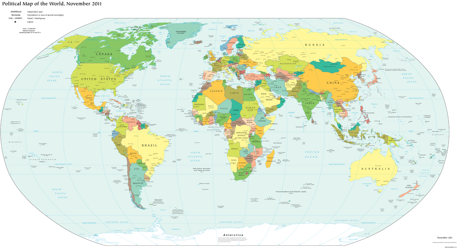
Map of the world's countries according to the U.S. Central Intelligence Agency
The lines and coloring on this map are hiding major truths about the world’s countries.
(Source: U.S. CIA; public domain)

1) Missing Countries
When choosing what counts as a country, most world maps go by either the official list from their own country or the member/observer roster from the United Nations. Just one problem: there are about ten countries which have declared and enforced their independence, but aren’t recognized by the U.N. or most of the world’s governments. These states may have close ties to a neighbor country, but most of them aren’t at all controlled by the country they’re supposed to be part of.

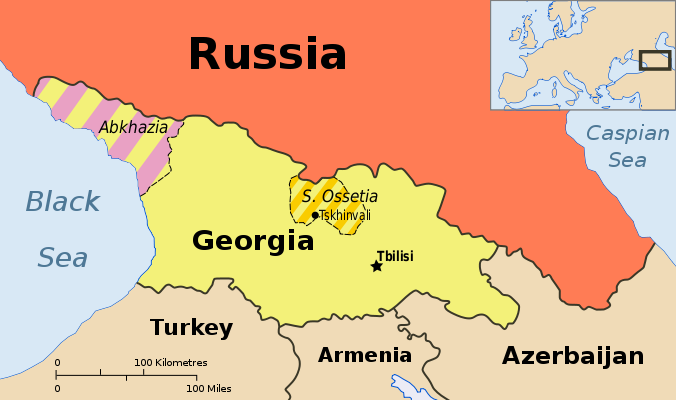
Map showing Abkhazia and South Ossetia, two breakaway states claimed by Georgia.
Abkhazia and South Ossetia operate as independent countries, but are claimed by Georgia and only recognized by a few countries. Map by Ssolbergj (CC BY-SA).

There are some high-profile special cases that warrant at least a note on many maps. Taiwan’s government formally claims to represent non-communist China, though it acts more like a separate country. Palestine, another disputed state, is now recognized as a U.N. observer country despite being forced to share control of its territory with Israel.

Western Sahara‘s status is considered unresolved by the U.N., and a small piece is effectively independent; meanwhile, Northern Cyprus is recognized only by its patron country, Turkey. The self-proclaimed Republic of Kosovo is now recognized by half of the U.N.’s members but not by the U.N. itself.

Other countries escape entirely from all but the most careful of political maps, being misleadingly merged into the countries that claim their territories: Abkhazia and South Ossetia into Georgia, Nagorno-Karabakh into Azerbaijan, and Transnistria into Moldova. These four breakaway states are sponsored by neighboring countries, but the most left out of all is Somaliland, which receives no major support or recognition from anyone, despite managing its affairs completely independently from Somalia.

Unrecognized Countries: More Articles and Maps

2) Incomplete Control
Drawing lines around a country on the map might imply that its government controls all the land within those lines. But that’s often not the case in reality. Even setting aside foreign military occupations like the recent U.S. interventions in Iraq and Afghanistan, many countries’ governments don’t control their whole territories. Aside from the cases of breakaway states as described earlier, this mainly occurs in war zones where rebel groups are actively vying for control of all or part of the country.

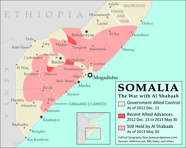
Map of government and Al Shabaab control in Somalia's ongoing civil war
Large parts of Somalia are controlled by Al Shabaab extremists. Click for map attribution info (CC BY-SA).

Somalia is probably the most infamous for this. Its U.N.-recognized government controls around half the country at best, and a few years ago controlled nothing but a part of the capital city! The rest is divided between the religious extremist Al Shabaab and various autonomous states which keep their own counsel on whether to cooperate with the government.

The territories of Mali, Nigeria, the Central African Republic, Libya, and Ivory Coast have all only recently been reunited (either under the former government or under the rebels), and Syria is the current model of a state falling apart through violence. Other countries with rebels firmly controlling parts of their territory are Yemen, the Democratic Republic of the Congo, and Myanmar/Burma.

Divided Countries: More Articles and Maps

3) Undefined Borders

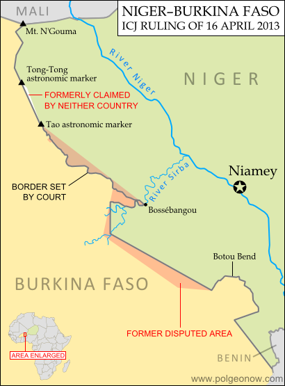
Map of the border dispute recently resolved between Niger and Burkina Faso
Niger and Burkina Faso recently resolved an unclear border situation. Map by Evan Centanni (click for details; CC BY-SA).

Another thing political maps imply is that borders at least have strictly defined locations in principle, even if they’re usually invisible on the ground. If they weren’t well-defined, they wouldn’t all be drawn with solid lines on the map, right? Wrong. Many countries have borders that have never been precisely defined by treaties, a process called “delimitation”.

Even fewer have been actually “demarcated”, or marked on the ground. In fact, undefined borders are such a big issue among the relatively young countries of Africa that the African Union operates an official border program to encourage the ongoing delimitation of national boundaries.

The fudge factor in national borders isn’t always big enough to make a difference to where they’re drawn on the world map – but their fuzziness can sometimes have major effects on international relations. An undefined border is a ripe environment for the birth of territorial disputes when neighboring countries have different ideas of where the border should run.

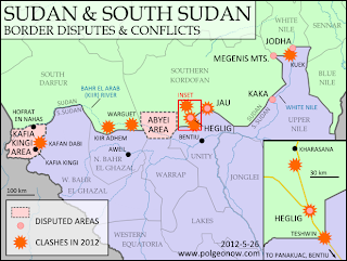
Sometimes these disputes are only low-level disagreements, such as the one recently resolved between Niger and Burkina Faso; but in other places like the border between Sudan and South Sudan, they can escalate into bloody conflicts.

Undefined Borders: More Articles and Maps

4) Disputed Territories
Your world map may label a few well-known territorial disputes, caused either by vague borders or conflicts over island groups. You might then reasonably conclude that disagreements over who owns a place, though they do happen, are relatively few and far between. Unfortunately, your conclusion would be incorrect. There are far more disputed territories in the world than you’ve probably ever imagined.

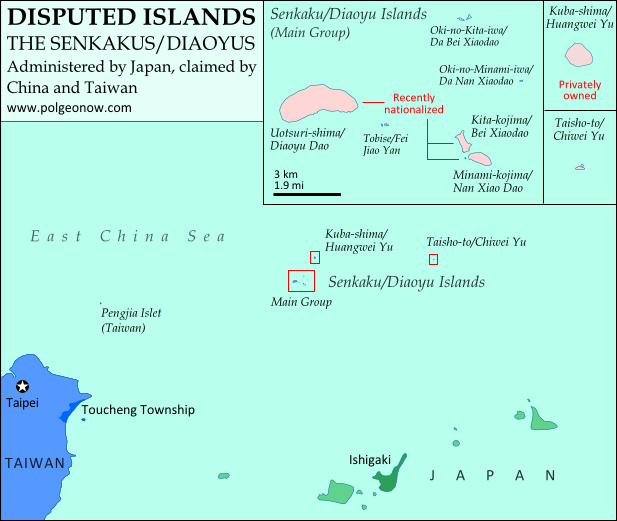
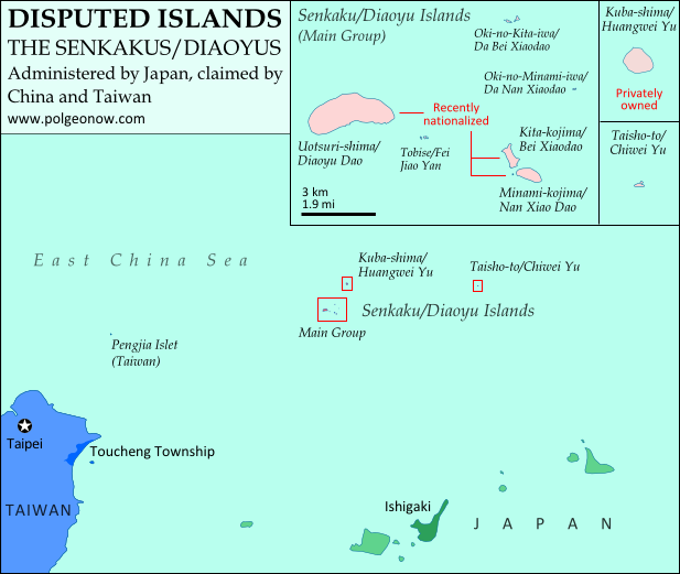
Map of the Senkaku/Diaoyu Islands, controlled by Japan but claimed by China and Taiwan
Map of the Senkaku/Diaoyu Islands, disputed between Japan, China, and Taiwan (map by Evan Centanni).

The most bizarre disputes range from high-profile cases, such as the five-way feud over the Spratly Islands, to quieter anomalies like Bir Tawil between Sudan and Egypt, both of whom claim it belongs to the other.

You may have heard of those, but did you know that (at least on paper) Mongolia is claimed by Taiwan? Or that more than half of Guyana is claimed by Venezuela? What about the several territories disputed between the U.S. and Canada? And those are just the land disputes – wait until you hear about the oceans!

Disputed Territories: More Articles and Maps

5) Territorial Seas
One thing completely left off of most maps is ownership of the sea. The occasional border lines you see across straits on your map are just showing who owns the islands on either side, not who owns the sea in between. The uninterrupted expanse of blue on most maps then might imply that the seas are the domain of no country. This is true for parts of the open ocean far from any coastline – but closer in, countries can and do exercise territorial rights over their neighboring seas. According to international best practices, a country is entitled to extend its territory up to 12 nautical miles (NM) out from its coastline, regulate economic activity out to 200 NM, and sometimes control seafloor oil and mineral exploration out to much further.
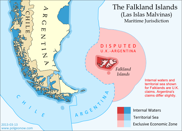
Map of territorial seas and exclusive economic zones (EEZ) around the Falkland Islands (Malvinas), controlled by the U.K. but claimed by Argentina
Both the land and the seas of the Falkland Islands are disputed between the U.K. and Argentina. Map by Evan Centanni (click for details; CC BY-SA).

But the divvying up of the world’s seas is still an ongoing process, and there are probably even more maritime disputes than land-based ones. Some countries, like Peru and Ecuador, refuse to recognize the 12 NM limit, claiming sovereign territory out to a full 200 NM. In even more cases, neighboring countries just can’t agree on where to draw the border between their respective territorial seas.

International law does provide guidance on how to divide it up, but for now many countries make claims far beyond what seems reasonable, apparently hoping they have something extra to give away in future negotiations. The most extreme claims, like China’s infamous “Nine-dotted Line” around most of the South China Sea, don’t seem to follow much legal logic at all.

Maritime Jurisdiction: More Articles and Maps

So next time you find yourself looking at a political map of the world, remember to be critical and take those borders with a grain of salt!

Other Articles You Might Like:
5 Countries You’ve Never Heard Of (by Their Native Names) 
How Many Countries Are There in the World?
Parade of Nations: Which Countries Are (and Aren’t) in the Olympics?
 

Japan-China Dispute: The Eight Islands of the Senkaku/Diaoyu Group (Aerial Photos)

Map of the Senkaku/Diaoyu Islands, disputed between Japan, China, and Taiwan; includes location as well as detail of islands
Map of the disputed Senkaku/Diaoyu Islands (by Evan Centanni). Click to view at full size.

Article by Evan Centanni

The Senkaku/Diaoyu Islands
A recent feature on Political Geography Now introduced the history and status of the Senkaku/Diaoyu Islands, a disputed territory controlled by Japan but claimed by China and Taiwan. The article included an original map which showed the isles’ configuration and precise location within the East China Sea (click on the map at right to see it at full size). But if you’re like me, you may be wondering “just how small are these islands, and what do they really look like?”

Luckily for you and me, aerial photographs of many places in Japan have been released by the Japanese government and uploaded with English labels to Wikimedia Commons. Included in the collection are shots of each of the disputed isles, known as the Senkaku Islands to the Japanese, the Diaoyu Islands to the Chinese, and the Diaoyutai Isands to the Taiwanese. Here are the photos and a brief profile of each island:

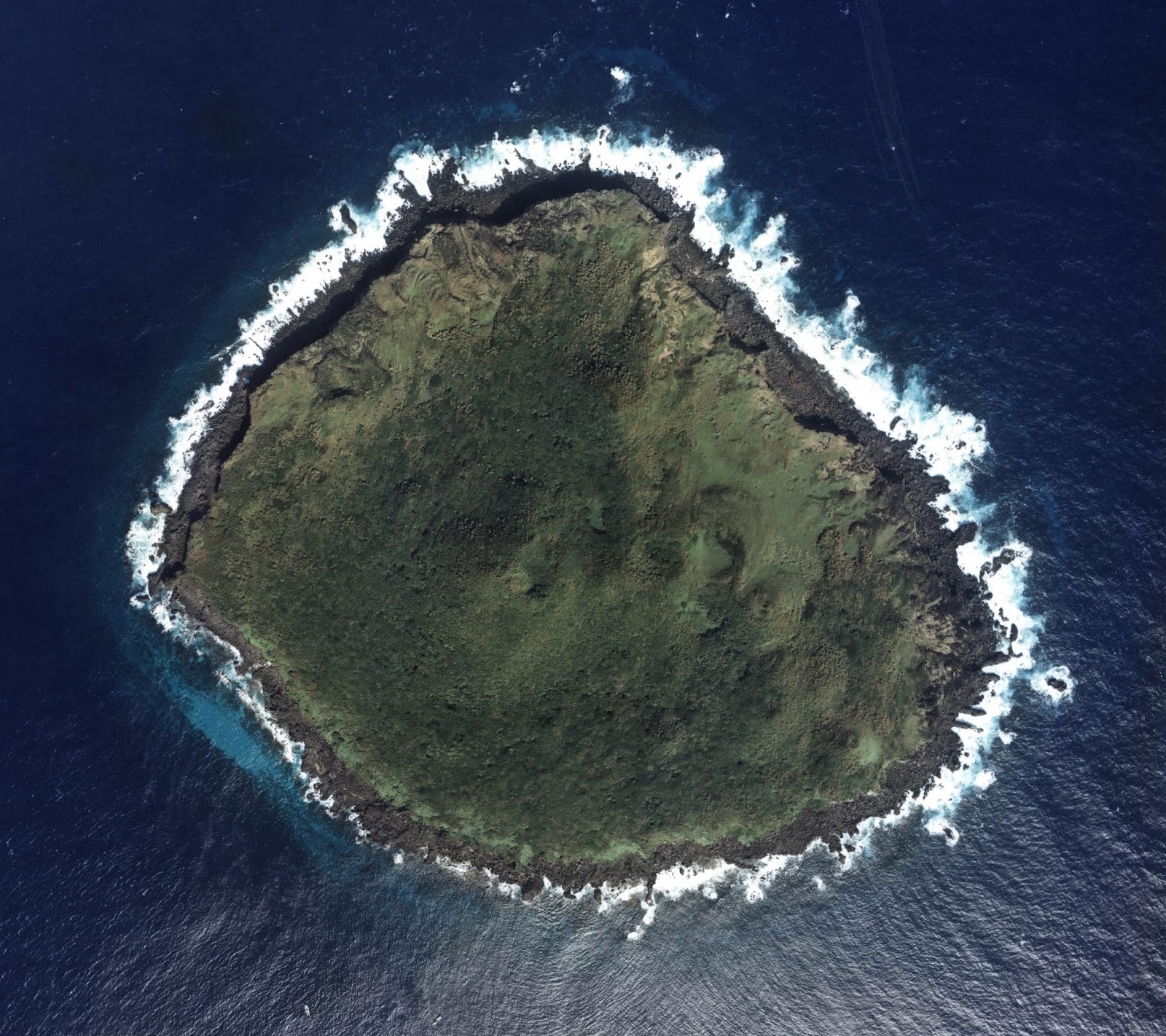
Aerial photo of Uotsuri-shima (魚釣島)/Diàoyúdǎo (钓鱼岛)/Diàoyútái (釣魚臺), the largest of the Senkaku/Diaoyu islands disputed between Japan, China, and Taiwan

Japanese: Uotsuri-shima (魚釣島)
Chinese (China): Diàoyúdǎo (钓鱼岛)
Chinese (Taiwan): Diàoyútái (釣魚臺)
Area: 4.32 km2 (1.67 mi2)
Highest Point: 383 m (1,257 ft.)
The largest isle in the disputed archipelago, Uotsori has been a center of historical activity in the Senkaku/Diaoyu Islands. It was the site of a Japanese fish-processing plant from about 1900-1940, when it hosted 200 workers. Since then it has been uninhabited, but was visited by a Japanese academic-governmental delegation for four weeks in 1979.

The island was one of four sold to the Kurihara family in the 1970s. The Japanese government rented the island from 2002, before finally buying it from the family last year. Though the island is no longer inhabited by humans, it is home to a population of domestic goats and albatross, as well as a species of mole found nowhere else on earth. Once called “Peaks Island” by the British, the current name means “Fishing Island” in both Japanese and Chinese (the name used by Taiwan is literally “Fishing Platform”). (photo source)

Aerial photo of Kita-kojima (北小島)/Běi Xiǎodǎo (北小島/北小岛) and Minami-kojima (南小島)/Nán Xiǎodǎo (南小島/南小岛), two major parts of the Senkaku/Diaoyu Islands disputed between Japan, China, and Taiwan

Japanese: Kita-kojima (北小島)
Chinese: Běi Xiǎodǎo (北小島/北小岛)
Area: 0.33 km2 (0.13 mi2)
Highest Point: 135 m (443 ft.)

Japanese: Minami-kojima (南小島)
Chinese: Nán Xiǎodǎo (南小島/南小岛)
Area: 0.46 km2 (0.18 mi2)
Highest Point: 149 m (489 ft.)
These are the only other major islands in the main cluster of the Senkakus. Like Uotsuri, they were sold to the Kurihara family in the 1970s, rented by the Japanese government from 2002, and bought by the government in 2012. The islands’ names are written the same in both Japanese and Chinese, and mean “Northern Little Island” and “Southern Little Island” respectively. (photo source

Aerial photo of Oki-no-Kita-iwa (沖の北岩)/Běiyǔ (北屿)/Chōng Běiyán (沖北岩)/Dà Běi Xiǎodǎo (大北小島)/Běiyán (北岩), group of rocks which form part of the Senkaku/Diaoyu Islands disputed between Japan, China, and Taiwan

Japanese: Oki-no-Kita-iwa (沖の北岩)
Chinese (China): Běiyǔ (北屿)
Chinese (Taiwan): Chōng Běiyán (沖北岩)
Other Chinese Names: Dà Běi Xiǎodǎo (大北小島), Běiyán (北岩)
Area: 0.02 km2 (0.01 mi2)
Highest Point: 28 m (92 ft.)
This is actually a small group of islets located in the northeast of the Senkaku Islands’ main cluster. It consists mainly of barren rocks, and has apparently never been privately owned. The Japanese and various Chinese names are variations on “Northern Islet” or “Northern Rock”; yet one name, Dà Běi Xiǎodǎo, means “Big Northern Little Island”, seeming ironically to imply that it outsizes the much larger Běi Xiǎodǎo (Kita-kojima). (photo source

Aerial photo of Oki-no-Minami-iwa (沖の南岩)/Nányǔ (南屿)/Chōng Nányán (沖南岩)/Dà Nán Xiǎodǎo (大南小島)/Nányán (南岩), group of rocks which form part of the Senkaku/Diaoyu Islands disputed between Japan, China, and Taiwan

Japanese: Oki-no-Minami-iwa (沖の南岩)
Chinese (China): Nányǔ (南屿)
Chinese (Taiwan): Chōng Nányán (沖南岩)
Other Chinese Names: Nán Běi Xiǎodǎo (大南小島), Nányán (南岩)
Area: 0.005 km2 (0.002 mi2)
Highest Point: 13 m (43 ft.)
Located at the eastern edge of the main cluster of the Senkaku Islands, this another barren rock which has apparently never been privately owned. Its names in Japanese and Chinese present it as the southern counterpart to Oki-no-Kita-iwa. (photo source)

Aerial photo of Tobise (飛瀬)/Fēiyǔ (飞屿)/Fēilài (飛瀨)/Fēiyán (飛岩)/Fēijiāoyán (飛礁岩), a reef which forms part of the Senkaku/Diaoyu Islands disputed between Japan, China, and Taiwan

Japanese: Tobise (飛瀬)
Chinese (China): Fēiyǔ (飞屿)
Chinese (Taiwan): Fēilài (飛瀨)
Other Chinese Names: Fēiyán (飛岩), Fēijiāoyán (飛礁岩)
Area: 0.0008 km2 (0.0003 mi2)
Highest Point: 2 m (7 ft.)
Tobise is a cluster of rocks located just southeast of Uotsuri, the biggest island of the Senkakus. Although the area of shallow water surrounding it gives it a larger profile on some maps, according to the Taiwan government’s measurements it is the smallest of the eight major named isles of the Senkaku/Diaoyu Islands. It is also the lowest, protruding little farther above the water than the height of a person. Its Japanese and Chinese names all translate to something like “flying shoals” or “flying reef”. (photo source)

Aerial photo of Kuba-shima (久場島)/Huángwěiyǔ (黃尾嶼/黄尾屿), one of the Senkaku/Diaoyu Islands disputed between Japan, China, and Taiwan

Japanese: Kuba-shima (久場島)
Chinese: Huángwěiyǔ (黃尾嶼/黄尾屿)
Area: 1.08 km2 (0.42 mi2)
Highest Point: 117 m (384 ft.) Kuba is the second largest of the Senkaku Islands, located to the north of the main cluster. In the 1970s, it was sold to the Kurihara family along with the three major islands of the main group, but was owned by the sister of the man who the other three belonged to. Today it is still owned by the family, but rented by Japan’s Ministry of Defense. The Japanese in turn allow the U.S. military to use it as a practice bombing range for aircraft. “Kuba” is a Japanese surname, and the Chinese name means “Yellow-tail Islet”. (photo source)

Aerial photo of Taishō-to (大正島)/Chìwěiyǔ (赤尾嶼/赤尾屿), one of the Senkaku/Diaoyu Islands disputed between Japan, China, and Taiwan

Japanese: Taishō-to (大正島)
Chinese: Chìwěiyǔ (赤尾嶼/赤尾屿)
Area: 0.06 km2 (0.02 mi2)
Highest Point: 75 m (246 ft.)
Taisho is the most distant of the Senkaku/Diaoyu Islands, located over 100 km (60 mi) to the east of the main group. A relatively high island for its size, it has been continuously owned by the Japanese government since Japan formally took possession of the islands in 1895. In Japanese, the island is probably named after Emperor Taishō, the Emperor of Japan at the time when the Senkakus were annexed and developed. The Chinese name means “Red-tail Islet”. (photo source)

(Photos from Wikimedia Commons, based on National Land Image Information (Color Aerial Photographs), Ministry of Land, Infrastructure, Transport and Tourism of Japan. Used under terms of copyright.)

Related Articles:

Niger and Burkina Faso Resolve Territorial Dispute

Disputed Territory: The Senkaku/Diaoyu Islands

You may have heard the news about China and Japan’s ongoing territorial dispute over a group of islands in the East China Sea. But what are the Senkaku/Diaoyu Islands, and why are they so fiercely contested? Read on for all these answers and more!

Map of the Senkaku/Diaoyu Islands, disputed between Japan, China, and Taiwan; includes location as well as detail of islands
Map of the disputed Senkaku/Diaoyu Islands (by Evan Centanni).

Article by Omar Alkhalili

About the Islands
The Senkaku/Diaoyu Islands are a collection of five small islets and three rocks in the East China Sea, all of which are uninhabited. The largest of the islands has an area of 4.32 km² and the smallest is only 0.45 km². They are located about 140 km from the nearest inhabited Japanese islands, 300 km from mainland China and 170 km from Taiwan. They are administered by Japan but claimed by both the People’s Republic of China (PRC) and Taiwan, whose government is known officially as the Republic of China (ROC).

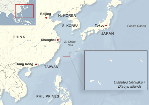
Map of the location of the disputed Senkaku/Diaoyu Islands within Asia
Location of the disputed Senkaku/Diaoyu Islands in Asia
Public domain graphic (source)

In English, the islets have historically been referred to as the Pinnacle Islands, but are now more often called by their Japanese and Chinese names. In Japan, they are known as the Senkaku Islands, whereas in mainland China they are called the Diaoyu Islands and in Taiwan they are referred to as the Diaoyutai (Tiaoyutai) Islands. They are administered by Japan as part of Ishigaki, a municipality in Okinawa Prefecture, while the PRC and ROC both consider them part of Toucheng township in Taiwan’s Yilan County, despite the fact that the two rival governments do not recognize each other.

While it considers the islands part of Ishigaki, Japan’s central government does not allow the city to develop or survey them. Four of the islands have been privately owned since 1932, but the government bought three of them last year after renting them for some time. One of the privately owned islands is still leased to the Japanese Ministry of Defense, which has allowed the United States military to use it as a practice bombing range for aircraft.

History of Claims and Control

Territory Name:  
Senkaku-shotō (Japanese)
• Diàoyúdǎo (Mandarin – China)
• Diàoyútái (Mandarin – Taiwan)
Pinnacle Islands (English – historical) 
Claimants: 
• Japan
• China (People’s Republic of China)
• Taiwan (Republic of China)
Actual Control: Japan
Administrative Status: Part of the country
Capital: N/A (uninhabited)

Japan, mainland China and Taiwan all root their claims to the Senkakus/Diaoyus in the region’s history. China was aware of the islands’ existence since the 15th century, and the PRC and ROC claim that the islands have been part of Chinese territory since at least the 16th century. However, the Japanese government holds that when it surveyed the islands in the late 1800s, they were uninhabited and showed no signs of having been under Chinese administration.

Japan took control of the islands in 1895, and with the exception of the American occupation of Japan from 1945 to 1972, has held onto them ever since. Both Chinas now consider the islands to be part of Taiwan province, which China ceded to Japan in 1895 after the First Sino-Japanese War. However, they hold that Japan returned the rights to the islands to China by surrendering to the Allied Powers at the end of World War II. Japan insists that these islands were not part of the territory that it gave up in surrendering, arguing that they were always considered part of the Ryukyu island chain rather than Taiwan. China and Taiwan did not voice their claim to the Senkaku/Diaoyu islands until after the U.S. occupation Okinawa ended in 1972.

On top of the historical claims, various economic issues complicate the dispute. The islands’ territorial waters include rich fishing grounds and lie along the path of strategically important shipping lanes. Potential oil reserves have also been identified nearby.

Current Dispute
In recent years, tensions over the Senkaku/Diaoyu Islands have flared between Japan and both Chinese governments. After a series of incidents in 1996 that included Japanese activists installing a light house on one of the islands and the death of a Chinese activist due to drowning, there have been continued instances of Chinese activists attempting to sail to the islands, resulting in their arrest and detention.

Aerial view of two of the Senkaku/Diaoyu Islands disputed between Japan, China, and Taiwan
Aerial photo of Kita-kojima/Bei Xiaodao and Minami-kojima/Nan Xiaodao in the Senkaku/Diaoyu Islands
(Courtesy of Japan National Land Image Information (Color Aerial Photographs, Ministry of Land, Infrastructure, Transport and Tourism; source)

In 2010, an incident involving the detention of a Chinese ship crew precipitated mass protests in Chinese cities. Two years later, before the Japanese government’s purchase of three of the islands, the then Governor of Tokyo came up with his own plan to buy the islands, sparking protests in China and resulting in the detention of a group of activists from Hong Kong. Mainland China has challenged Japanese control of the islands through incursions into their territorial waters and airspace. In 2013, the mainland government announced that it plans to survey the islands in order to safeguard its maritime interests.

Recently, some progress has been made in resolving the dispute, with Japan and Taiwan arriving at an agreement allowing Taiwanese fishermen access to a large portion of the island’s surrounding waters. This agreement may create an obstacle for mainland China as its government becomes isolated in its efforts to challenge Japanese control. However, Taiwan still retains its claims to the Senkakus/Diaoyus, and there is no clear end in sight for the dispute between the three governments.

Omar Alkhalili is a contributor to Political Geography Now. He is a graduate of Ramapo College of New Jersey with a Bachelor of Arts Degree in Political Science. He can be reached at omaralkha@gmail.com.

See Also: The Eight Islands of the Senkaku/Diaoyu Group (profiles and aerial photos)

Related Articles:

Niger and Burkina Faso Resolve Territorial Dispute

Who Recognizes Palestine in 2013?

(Keep up with changes to Palestine’s situation: view all Palestine updates.)

 Palestine is now an Observer State in the U.N., but it’s still not recognized individually by all U.N. member countries. Read on for more about the latest countries to recognize Palestine, plus other recent changes to its international status.

Map of countries that recognize the State of Palestine as an independent country, updated for May 2013 with most recent additions highlighted
Countries recognizing the State of Palestine in green, with most recent additions highlighted in lighter green. Palestine in magenta (circled). Map by Evan Centanni, modified from public domain graphic (source).


By Evan Centanni

Countries that Recognize the State of Palestine
Despite opposition from Israel, the U.S., and other Western countries, Palestine was recognized as an Observer State by the U.N. last year. However, recognition by individual countries is a separate matter. In September of 2011 we reported that the declared State of Palestine had accumulated recognition from 126 U.N. members plus partially-recognized Western Sahara. But have more states recognized Palestine as an independent country since then?

Yes, a few. As highlighted on the map above, several more U.N. member countries have recognized the State of Palestine over the last year and a half. New additions since our previous update are the Caribbean island nations of Dominica, Antigua and Barbuda, and Grenada, plus Thailand in Southeast Asia and Iceland in Europe. The latest, recognizing Palestine for the first time just last month, is the Central American state of Guatemala.

Flag of Palestine Country Name:  
• Palestine (English)
Filasṭīn (Arabic)
Official Name:  
• State of Palestine (English)
• Dawlat Filasṭin (Arabic)
Capital: 
• Jerusalem (claimed)
Ramallah (administrative)

This brings the total number of U.N. members that consider Palestine a sovereign state to 132, or about 68 percent. Or could it be more? Last year, before Guatemala’s announcement, the Palestinian government was already claiming recognition from 132 countries, and the U.N. resolution which made it an Observer State mention that Palestine was already recognized by 132 “members of the United Nations”. However, no additional recognitions have emerged in the months since then, so it seems likely that it was an error. The number 132 probably refers to the 131 U.N. members recognizing at the time, plus Western Sahara.

Wikipedia: List of countries recognizing Palestine

Palestine in UNESCO
Also since our September 2011 report, Palestine was accepted as a member of the United Nations Educational, Scientific and Cultural Organization (UNESCO), a specialized agency of the U.N. This happened before its elevation to Observer State status in the General Assembly, and was quite controversial at the time. It was speculated that becoming an Observer State would increase the likelihood of Palestine being accepted into more U.N. organizations in the future – however, this has not yet happened.

Change of Standard ISO Name
Another change to Palestine’s treatment internationally came with a February 2013 update to the standard list of country codes and names from the International Organization for Standardization (ISO). This standard, which is used by many organizations and companies around the world, is tied to official United Nations usage. After the Palestinian government received Observer State status from the U.N., its name was changed in the standard from “the Occupied Palestinian Territory” to “the State of Palestine”.

Online company Google caused a bit of a stir last week when it changed the name of its Palestinian search page from “Palestinian Territories” to “Palestine”, receiving criticism from the Israeli government. However, Google argued that it was not making a political statement, but only following the lead of the U.N. and the standard used by websites around the world.

Check For Updates: See more recent recognition reports by viewing all Palestine posts.

Related Articles:

Is Palestine Really a Country?

Niger and Burkina Faso Resolve Territorial Dispute

Update: In May 2015, Niger and Burkina Faso formally agreed to implement this ICJ ruling, with the practical aspects of exchanging territories to be completed by the end of the following year.

Map of the disputed territory between Niger and Burkina Faso, which was divided between the two countries in an April 2013 ruling by the International Court of Justice
Map by Evan Centanni. Sources: ICJ, Natural Earth. Africa inset based on this map by TUBS/Wikimedia Commons (CC BY-SA).

By Evan Centanni
 
Border Dispute Settled
Last week, a territorial dispute between the West African countries of Niger and Burkina Faso was resolved peacefully with a ruling from the International Court of Justice (ICJ). Both countries’ governments agreed to respect the court’s ruling on where their border should lie, a question which had persisted ever since they both achieved independence in 1960.

In the ruling, the court drew an official border based on a careful analysis of a 1927 document establishing the pre-independence boundary between the two former French colonies, also turning to a 1960 French map which both countries had agreed to use as a secondary reference. The new border splits the disputed area between Burkina Faso and Niger, and will help put an end to confusion regarding policing and tax collection in the border area.

The ICJ, or World Court, is a part of the U.N., and is tasked mainly with arbitrating disagreements between U.N. member countries. It should not be confused with the International Criminal Court (ICC), which prosecutes individuals for war crimes. Niger and Burkina Faso had agreed by treaty to send the case of their disputed border to the ICJ for settlement, and both have expressed satisfaction with the result.

Further Reading: Full Text of ICJ ruling on Burkina Faso/Niger Frontier Dispute (PDF)

Unclaimed Land
An interesting curiosity noted in this case is that Burkina Faso and Niger’s respective border claims left a small strip of land claimed by neither country. The area, stretching between two locations referred to as the Tong-Tong and Tao astronomic markers, was left unclaimed because Burkina Faso considered the border to be a straight line running between the two markers, while Niger also respected a third marker placed a bit east of the line.

The third marker had originally been intended to lie exactly along the line between Tong-Tong and Tao, but was placed inaccurately. It is not entirely clear why Niger would choose to define its border in a way that would give it less territory than did Burkina Faso’s definition, but in any case the court discounted the third marker, giving the strip of land to Niger in the final ruling. A more famous (and still outstanding) case of a territory not claimed by any country is the Bir Tawil “triangle” between Egypt and Sudan.

Related Articles:

North Kosovo Status Changing after Serbia Deal

North Kosovo Status Changing After Serbia Deal

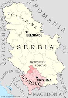
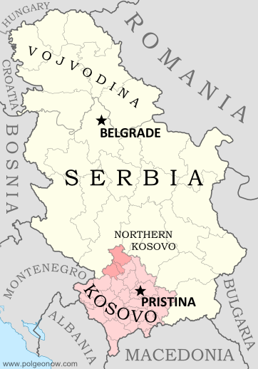
Map of Serbia, Kosovo, and North Kosovo
Map by Evan Centanni, based on these two blank maps by Nord-NordWest. License: CC BY-SA

Kosovo & Serbia in Historic Agreement
Serbia and the breakaway Republic of Kosovo reached a landmark deal on Friday to normalize their relations, partially compromising on several contentious issues between the two governments in southeastern Europe. Kosovo declared its independence from Serbia in 2008, but due to Serbia’s opposition it has still not achieved full international recognition. 

Status Change for North Kosovo
North Kosovo is the largest of several areas within Kosovo where the majority of people are part of the Serb ethnic group, whereas 90% of people in Kosovo as a whole are ethnically Albanian. When Kosovo split from Serbia, many Serbs in the north refused to go, governing themselves separately from Kosovo and choosing instead to continue cooperating with and accepting government funding from Serbia.

Territory Name:  
• North Kosovo (English)
• Severno Kosovo (Serbian)
Kosova Veriore (Albanian)
Claimants: 
• Republic of Kosovo
• Serbia
Actual Control: Local pro-Serbia groups, foreign peacekeepers
Status: No official status
Capital: Kosovska Mitrovica (de facto)

Under the new agreement, Serbia will stop treating North Kosovo as part of its territory, in exchange for the region receiving a degree of autonomy within Kosovo. Notably, Serbs in North Kosovo will now be able to legally manage their own police force. However, there may still be a bumpy road ahead, since Serb leaders in North Kosovo are refusing to accept the compromise.

Flag of the Republic of KosovoCountry Name:  
• Kosovo (English, Serbian)
• Kosova (Albanian)
Official Name:  
Republic of Kosovo (English)
Republika e Kosovës (Albanian)
Republika Kosovo (Serbian)
Status: Partially recognized; claimed by Serbia
Capital: Pristina/Prishtina

Eligibility for EU

The biggest benefit Serbia gets out of this week’s deal is eligibility to apply for membership in the European Union (EU). The EU, which admits new members on a case-by-case basis, had told Serbia it would never be considered unless it first relinquished control of North Kosovo. Serbia has also agreed not to get in the way if Kosovo applies to join the EU too.

Serbia Still Not Recognizing Kosovo
The Holy Grail for Kosovo would have been official diplomatic recognition of its independence from Serbia. However, the agreement stopped short of Serbia calling Kosovo an independent country. Kosovo’s Prime Minister has claimed that the deal counts as recognition anyway, but Serbia has emphatically denied this.

Kosovo is recognized as independent by about half of all the world’s countries, including the majority of the EU and NATO, but opposition from Serbia and Russia has kept it locked out of the UN. For a current map of all of the countries that recognize Kosovo, see Kosovo Recognition Update: April 2103.

Article by Evan Centanni. Kosovo flag graphic by Cradel (source) (CC BY-SA).

What is North Korea?

North Korea’s threats of war have captured the world’s attention in recent weeks, leaving citizens of other East Asian countries anxiously awaiting the latest news. A new war is unlikely, but how much do you know about North Korea, its international status, and its dispute with the south?

Map of North Korea and South Korea
Map by Johannes Barre & Patrick Mannion (CC BY-SA) (source)

What is North Korea?
Located on the northern half of the Korean Peninsula between South Korea and China (and sharing a short border with Russia), North Korea is a medium-sized East Asian country of about 24 million people. Despite its size, it boasts the fourth-largest army in the world, and has remained officially at war with South Korea since 1950.

Sometimes considered one of the world’s last remaining communist states, North Korea actually claims no longer to follow communist ideology. However, it surely does hold the distinction of having the world’s most closed borders, with its totalitarian government tightly controlling the flow of information and people in and out of the country.

What territory does North Korea claim?
North Korea doesn’t actually have “north” in its official name, which is the Democratic People’s Republic of Korea (DPRK). This is because it claims to be the rightful government of all of Korea, including the south. South Korea (officially the Republic of Korea) also maintains the same claim, with both sides seeking eventual unification. Korea hasn’t been a single independent country for over 100 years, since it lost its independence in 1905 and was absorbed into the Japanese Empire in 1910.

How did Korea become divided?

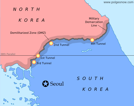
Map of the Military Delimitation Line (armistice line) and Demilitarized Zone (DMZ) separating North and South Korea
Armistice line and DMZ dividing North and South Korea. Modified by Evan Centanni from this map by Rishabh Tatiraju (CC BY-SA).

When Japan lost World War II in 1945, Korea was divided temporarily between U.S. and Russian control, with the boundary placed arbitrarily at the latitude 38° north. However, the Russian-held area in the north and the U.S.-held area in the south ended up forming two rival governments, a political situation that culminated with the north’s 1950 invasion of the south.

In the first large-scale conflict of the Cold War, an American-led U.N. intervention force fought off the Russian- and Chinese-supported north in the three-year-long Korean War. The armistice that brought fighting to an end in 1953 drew a new boundary close to the old one, but not as straight, also establishing a 4 km (2.5 mi) wide Demilitarized Zone (DMZ) around the line. However, because both Koreas seek reunification, neither recognizes the armistice line as an official border.

Map of North and South Korea's differing claims for their maritime boundary in the Yellow Sea
Korean boundary in the Yellow Sea: the U.N.’s Northern Limit Line (A) and North Korea’s claimed line (B). Map modified by Evan Centanni from this one by Amble, 玖巧仔 and Tomchen1989 (CC BY-SA).

Are there any other “disputed territories” between North and South Korea?
Yes – although technically the entire Korean peninsula is disputed between the north and the south, even the unofficial boundary is contested in the Yellow Sea off Korea’s west coast. The armistice agreement didn’t specify a sea boundary, and U.N. forces later drew a simple line running between North Korea and the nearest South Korean islands (the Northern Limit Line). However, North Korea has rejected this boundary, drawing its own line to carefully avoid the South’s islands while claiming the surrounding waters for itself.

What is North Korea’s international status?
Despite North Korea and South Korea claiming to represent the same larger Korea, they are both members of the U.N., after being admitted at the same time as Cold War politics were thawing in 1991. North Korea is now acknowledged around the world as an independent country, with only South Korea and Japan refusing to recognize it. Meanwhile, North Korea maintains active diplomatic relations with most of the world’s countries, with a few major exceptions, such as the U.S. and France.

Flag of North Korea (Democratic People's Republic of KoreaCountry Name:  
• North Korea (English)
• Chosŏn (Korean)
Official Name:  
• Democratic People’s Republic of Korea (English)
• Chosŏn Minjujuŭi Inmin Konghwaguk (Korean)
Capital: Pyongyang

Article by Evan Centanni

Map: The Falkland Islands’ Disputed Seas

The Falkland Islands, a South Atlantic territory disputed between the U.K. and Argentina, held a status referendum this week in which 99.8% of voters defied Argentina by choosing to remain British. But it’s not just about the islands – also at stake are legal rights to the sea for hundreds of miles around.

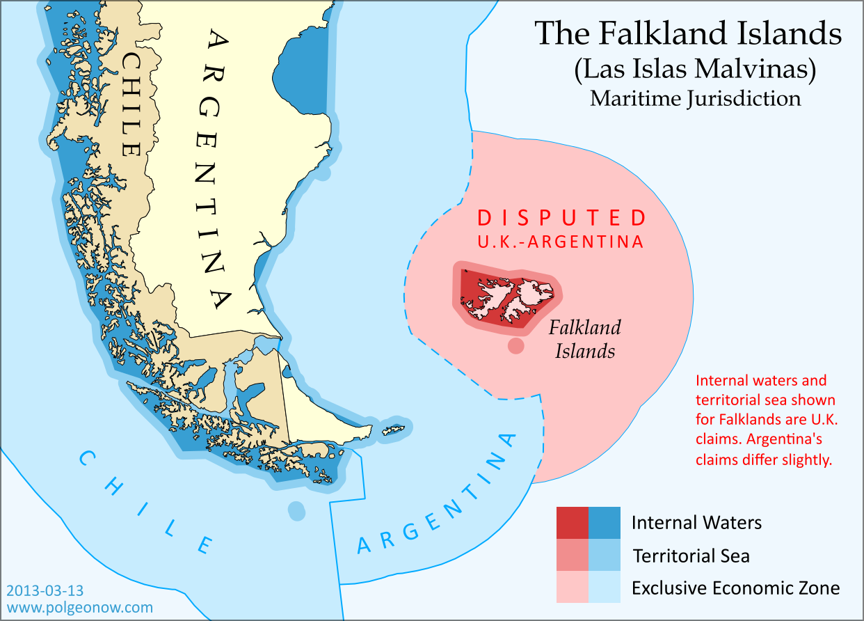
Map of maritime jurisdiction in the seas surrounding the Falkland Islands (Islas Malvinas), including territorial sea, internal waters, and exclusive economic zone (EEZ)
Zones of maritime jurisdiction around the Falkland Islands, highlighting area disputed between the U.K and Argentina. Map by Evan Centanni (country coastlines from the Natural Earth dataset). All rights reserved.

The Disputed Seas of the Falkland Islands
The Falkland Islands are administered by the U.K. as an overseas territory, but are also claimed based on historical arguments by Argentina, which calls them “las Islas Malvinas”. Both countries have signed and ratified the United Nations Convention on the Law of the Sea (UNCLOS), which defines ownership and legal rights for the waters surrounding coastal countries. According to the UNCLOS, each country is entitled to three basic zones of control in its surrounding seas:

Internal Waters
These areas normally include bays and the water between islands or between the islands and the mainland. With some exceptions, internal waters are considered legally equivalent to rivers and lakes, which means the country has total control here. Both the U.K. and Argentina claim an area of internal waters in the Falklands, though their claims are slightly different. Only the British claim is shown on the map above – the Argentine claim is a bit smaller, excluding the channel between the two main islands but stretching farther out to the most distant rocks.

Territorial Sea
The territorial sea is an area stretching up to 12 nautical miles out from the edge of the land or internal waters, which is considered sovereign territory of the state (i.e. an actual part of the country), though the “innocent passage” rule requires that foreign ships still be allowed to sail there without permission. Both the U.K. and Argentina claim a 12 nautical mile territorial sea surrounding the Falkland Islands. The two countries’ claims are slightly different because they’re drawn from the edges of the differing internal waters claims. The U.K. claim is shown on the map above (the small circle at the bottom is the territorial sea around Beauchene Island).

Flag of the Falkland Islands Territory Name:  
Falkland Islands (English)
• Islas Malvinas (Spanish)
Claimants: 
• United Kingdom (U.K.)
• Argentina
Actual Control: U.K.
Status: Overseas Territory (self-governing)
Capital: Stanley

Exclusive Economic Zone (EEZ)
Although the waters beyond the territorial sea are not considered part of the country itself, the country still has some legal rights over the surrounding ocean, up to a maximum distance of 200 nautical miles from the coast or internal waters. This is called the “exclusive economic zone”, and here countries can control the harvesting of resources, scientific research, and environmental protection. When two countries are less than 400 nautical miles apart, they have to come to an agreement about where to draw the border of their EEZs (the default is normally to draw a line halfway between the two coasts).

The Falklands are indeed less than 400 nautical miles from mainland Argentina, but the Argentine government doesn’t consider this to be a problem, because they consider both the mainland EEZ and the Falkland EEZ to be theirs. The U.K. also claims the waters around the Falklands (though it calls them a “fishery conservation zone” instead of an EEZ), but draws its line short of the halfway point between the islands and Argentina. This might be intended as a show of modesty, though Argentina isn’t flattered, since it doesn’t think the U.K. should be there in the first place.

The Continental Shelf
Beyond the end of the EEZ, countries are also allowed to claim economic rights to the seafloor (but not the water above it), if it is part of the “continental shelf”. The legal definition of this term is a bit different from the way geologists use it, but the basic idea is that if the continent or landmass extends out a ways underwater before giving way to the deep sea, the shallow area is the continental shelf.

This is limited to 350 nautical miles from the shore, as well as detailed rules defining the required depth and slope of the sea floor. But since the U.K. and Argentina both also claim South Georgia and the South Sandwich Islands (not to mention parts of Antarctica), their conflicting continental shelf claims continue southeast from the Falklands EEZ for hundreds of miles. If you’re interested in this extended disputed territory between the U.K. and Argentina, check out this excellent online map made by Durham University’s International Boundaries Research Unit.

Who Really Controls the Seas of the Falkland Islands?
Actual control of these seas follows the U.K.’s claims, since that’s the country that actually controls the islands. Argentina insists this is illegal, and even temporarily occupied the islands in 1982; but it’s unlikely control will change any time in the near future, since the U.K. insists it won’t go against the will of the islanders (most of whom are proudly British, and many of whom have bad memories of Argentina from the 1982 war).

Graphic of the Falkland Islands flag is in the public domain (source).

Is Palestine Really a Country?

(Keep up with changes to Palestine’s situation: view all Palestine updates.)

Palestine is now recognized as a country by both the U.N. and a majority of its members, but many  have questioned whether this new-found status reflects the truth on the ground. Is Palestine really an independent country, or is this a political fantasy concocted by supporters in the U.N.?

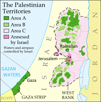
The Olso Accords divided the Palestinian territories into three areas of control (see article for explanation). Map by Evan Centanni. Sources: Natural Earth, B’Tselem, U.N. OCHA oPt.

What is a “sovereign state”?
By the most common definition, a “state” has to have:

  1. A government
  2. A defined territory
  3. A permanent population
  4. The ability to conduct foreign relations with other states

This definition is called the “declarative theory of statehood“, and was formalized in the Montevideo Convention of 1933. To be a “sovereign” state (i.e. an independent country), it’s also important that the government answers to no other country, and that the territory and population are actually under the government’s control.

A prospective country that fits these criteria is described by geographers as a de facto sovereign state, even if it’s not recognized by the international community (de facto is Latin for “in actual fact”).

Palestine: Sovereign State or Not?
Can Palestine be considered a real, de facto sovereign state based on the declarative theory of statehood? Let’s look at the criteria one by one:

A government that answers to no one
Palestine is represented abroad by the Palestinian Liberation Organization (PLO), and governed within its administrative area by the Palestinian National Authority (PNA), an elected government established by the PLO under the Oslo Accords. Though it faces frequent pressure and demands from Israel, the Palestinian government does not take orders from any country.

Defined territory under its control
The State of Palestine claims two territories: the West Bank and the Gaza Strip. The U.N. considers both of these regions to be occupied by Israel, but the Palestinians do control some parts of them since 1995. The Oslo II Accord temporarily designated three types of control within the West Bank (see map above):

  • Area A – Fully governed by the Palestinians, with no Israeli administration or Israeli military presence (currently 18%)
  • Area B – Shared control; Palestinian civil administration with joint Israeli-Palestinian military control (currently 21%)
  • Area CFull Israeli control, with some exceptions for Palestinian residents (currently 61%)
Flag of Palestine Country Name:  
• Palestine (English)
Filasṭīn (Arabic)
Official Name:  
• State of Palestine (English)
• Dawlat Filasṭin (Arabic)
Capital: 
• Jerusalem (claimed)
Ramallah (administrative)

The Gaza Strip is a special case: Israel withdrew from the territory in 2005, leaving it effectively part of Area A. However, a brief Palestinian civil war in 2007 left Gaza in the hands of extremist group Hamas, which currently doesn’t answer to the PLO (though it did support the campaign for U.N. observer state status). [Update: As of June 2014, Gaza and the West Bank are nominally united under a Palestinian unity government.]

Besides area C, Israel also controls all of the airspace and territorial waters associated with the West Bank and Gaza Strip. Additionally, it has completely annexed (integrated as part of the country) two sections of Area C itself: East Jerusalem, which both sides claim for their capital, and a strip of “no man’s land” which was located between Israel and the West Bank when the latter was still controlled by Jordan.

In other words, Israel controls most of Palestine’s claimed territory, but not all of it. Since many countries don’t control all of their claimed land and waters, that alone doesn’t disqualify Palestine as a state.

A permanent population
There are almost four million Palestinians living within the West Bank and the Gaza Strip, so this requirement is no problem. Even if we only count the West Bank’s Area A, the Palestinian Authority has full control  over close to one million people. By comparison, there about 40 U.N. member states with populations of less than one million.

Ability to conduct foreign relations
This requirement is also clearly fulfilled. Not only is Palestine seated as an observer state in the U.N. General Assembly, but its representatives also maintain direct diplomatic relations with 142 countries (even more than the number who recognize its independence), plus the European Union. It’s also a member or observer in various international organizations.

So what’s the answer?
Palestine has its own government (the PLO/PNA), a defined and controlled territory (Area A in the West Bank), a permanent population (one to four million Palestinians), and the ability to maintain relations with other states. So whatever we think about what should happen in the future, Palestine does seem to qualify as a de facto sovereign state at the present.