South Sudan Rebellion: Map Update 2 (Premium Content)

Map of rebel control in South Sudan's ongoing rebellion, updated to Jan. 16, 2014

Download PDF
buy

(Subscribe via Paypal)

Both peace talks and fighting continue nearly two weeks after our last South Sudan update. In the meantime, there have been several changes to rebel control. The newly updated premium map and report reflect those events, as well as newly available information about other localities. Buy now (US$2.99).

Premium article includes:

  • Exclusive updated map of rebel control in South Sudan’s ongoing uprising (current as of January 16, 2014)
  • A number of new localities have been added to the map since last time
  • Report chronicling changes to territorial control since the previous map, with links to sources

Members click here to proceed to article and map

Not a member yet? Subscribe Now!

Iraq: Map of Al Qaeda Control

There are newer versions of this map available. To see them, view all Iraq updates.

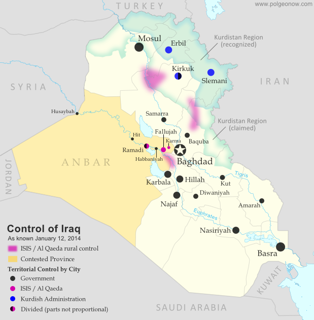
PolGeoNow presents our first map of Iraq, showing control by the government and Al Qaeda rebels in the country’s ongoing crisis. Areas of autonomous Kurdish administration in the north are also indicated.

Want to see timely updates for this map? Subscribe to our premium member service!

Map of territorial control in Iraq in January 2014, including cities and countryside held by Al Qaeda (ISIS) as well as areas administered by Kurdistan
Territorial control in Iraq at the beginning of 2014. Map by Evan Centanni, starting from this blank map by German Wikipedia user NordNordWest. License: CC BY-SA

Premium members click here to view this article in the ad-free members area. Not a member yet? Subscribe now!

By Evan Centanni

Al Qaeda in Iraq
Though the reality is of course more complex, power politics in Iraq often revolve around the country’s three largest ethnic groups: Shia (Shiite) Arabs, Sunni Arabs, and Kurds (most Kurds are religiously Sunni, but their language and cultural distinguish them from Arabs). Prime Minister Nouri al-Maliki, a Shia Arab, is often accused of manipulating Iraq’s democracy to exclusively serve the country’s Shia majority. The Kurds govern a highly autonomous region in the northeast, but the Sunni Arabs who dominate northwestern Iraq have relatively little political power. Into the fray has jumped Al Qaeda in Iraq, now part of the Islamic State of Iraq and al-Sham (ISIS) organization which also controls parts of Syria (map). Al Qaeda has waged a fierce campaign against the Iraqi government in the name of Sunnis, though the group is still rejected by many of the people it claims to protect.

Past Territorial Control
During the height of the Iraqi insurgency, Al Qaeda controlled large swaths of northern and central Iraq, including areas of the capital, Baghdad. Over the next few years it lost most or all of its territory, but has recently been making a gradual comeback. A map from the Reuters news agency last month shows a surprisingly large number of areas apparently under Al Qaeda’s influence, though scholarly research from the Institute for the Study of War determined just three major areas of control for the group (shown with shading on our map).

Flag of IraqCountry Name:  
• Iraq (English, Kurdish)
• al-‘Irāq (Arabic)
Official Name:  
• Republic of Iraq (English)
• Jumhūriyyat al-‘Irāq (Arabic)
Komara Iraqê (Kurdish)
Capital: Baghdad

Cities Captured
Things changed early this month, when a botched government crackdown resulted in Al Qaeda fighters taking control of the two largest cities in the western province of Anbar. It started when Prime Minister Maliki ordered the army to clear a one-year-old camp of Sunni protesters in the city of Ramadi, which he claimed Al Qaeda was using as a base.

After clashes with enraged local militias, Maliki agreed to withdraw the army. But soon after he did so, Al Qaeda launched a large-scale attack on Ramadi and nearby Fallujah. The army returned, and a three-way struggle ensued between government forces, Al Qaeda, and local militias who supported neither. On January 3, Al Qaeda fighters of ISIS declared Fallujah an independent Islamic state, and both Fullujah and Ramadi were reportedly under partial control of the militants. By the next day, they were said to be in nearly full control of Fallujah, as well as the nearby town of Karma.

ISIS also apparently captured several other towns along the Euphrates River, but a few – including Hit, Habbaniyah, and the Husaybah border crossing with Syria – were quickly retaken by the Iraqi army. Still, to control Anbar’s two major cities is to dominate the province as a whole. And although government forces have been making steady progress in retaking Ramadi, at least 10% of the city is reportedly still under Al Qaeda control. Fallujah still remains in rebel hands, though some local leaders claim that power is held by local militias rather than the ISIS/Al Qaeda fighters.

Graphic of the Iraqi flag is in the public domain (source).

South Sudan: Rebel Control Map Update (Premium Content)

There are newer versions of this map available. To see the full list of updates, view all South Sudan articles

Map of rebel control in South Sudan's 2013-2014 political crisis, updated to Jan. 3, 2014

Download PDF
buy

(Subscribe via Paypal)

Since our first map report on rebel control in South Sudan’s political crisis, the situation has continued to develop quickly, with several cities and towns changing hands. PolGeoNow now presents an updated map and report exclusively available as premium content for purchase and to our subscribers. Buy now for only US$2.99!

Premium article includes:

  • Exclusive updated map of rebel control in South Sudan’s ongoing uprising 
  • Report chronicling changes since the previous map, with links to sources

Members click here to proceed to article and map

Not a member yet? Subscribe Now!

South Sudan Crisis: Rebel Control Map (Premium Content)

There are newer versions of this map available. To see the full list of updates, view all South Sudan articles

Report and map of rebel control in South Sudan's December 2013 political crisis; includes indications of control by state and city, including Juba, Bor, Bentiu, Malakal, and more

Download PDF
buy

After a sudden outbreak of political violence last week, the military of South Sudan has fragmented into two competing factions, with rebellious defectors capturing a large swath of the world’s newest country. PolGeoNow now presents the first map of rebel control in South Sudan’s ongoing crisis, an exclusive for premium subscribers and purchasers.

Premium article includes:

  • Exclusive, up-to-date map of rebel control by state and city in South Sudan’s ongoing uprising
  • Outline of the course of events so far, including the captures of three state capitals by rebel forces
  • Brief description of the causes and humanitarian consequences of the current conflict

Members click here to proceed to article and map

Not a member yet? Subscribe Now!

Syria Civil War Map: December 2013 (#12)

There are newer versions of this map available. To see them, view all Syria updates.

In addition to updates on the situation, our updated Syria control map now distinguishes the territory of extremist groups ISIS and Al-Nusra from that of Free Syrian Army or mixed rebel coalitions. (To see other maps in this series, view all Syria updates.)

Tired of waiting months for Syria map updates and briefings? Subscribers to our premium member service will soon begin seeing much more frequent Syria control updates. Don’t miss out – sign up now!

Map of fighting and territorial control in Syria's Civil War (Free Syrian Army rebels, Kurdish groups, Al-Nusra Front, ISIS/ISIL and others), updated for December 2013. Includes recent locations of conflict and territorial control changes, Al-Safira, Khanaser, Maaloula, Qara, Nabek, and .
Area of fighting and territorial control in Syria’s civil war, updated for December 2013. Map by Evan Centanni, starting from this blank map by German Wikipedia user NordNordWest. License: CC BY-SA

Premium members click here to view this article in the ad-free members area. Not a member yet? Subscribe now!

Al-Nusra and the ISIS
In addition to updates on the situation since our previous Syria war map, this edition of the map also shows which cities are controlled primarily by religious extremist groups the Al-Nusra Front and the Islamic State of Iraq and Syria (ISIS) (also translated from Arabic as ISIL, the Islamic State of Iraq and the Levant). While these groups share many of their goals with the Free Syrian Army and other rebel groups fighting the Assad government, and in many cases still cooperate strategically with those groups, they are increasingly emerging as a separate bloc in the multi-sided conflict.

Though most of the rebels in Syria are Sunni Muslims, many of them hope to establish a secular democracy with representation for all Syrians. Al-Nusra and ISIS, on the other hand, base their entire organizations around a violent extremist religious ideology. Both are affiliates of Al Qaeda, and have claimed responsibility for many of the most brutal atrocities committed during the war. Unlike the Free Syrian Army (FSA) and other rebel groups operating in the country, which are apparently made up mostly of native Syrians, Al-Nusra and ISIS include large proportions of foreign fighters. In fact, ISIS is the same group once known as Al-Qaeda in Iraq, and has been part of the insurgency in that country since soon after the Iraq War began in 2003.

Flag of Syria under the current governmentCountry Name:  
• Syria (English)
• Sūriyya/Sūryā (Arabic)
Official Name:  
• Syrian Arab Republic (English)
• al-Jumhūriyyah al-‘Arabīyah  as-Sūriyyah (Arabic)
Capital: Damascus

These two groups have emerged as the most powerful and effective fighting forces in Syria, and are responsible for many of the rebel victories over the last year and beyond. And although the Syrian rebels have rarely if ever been united under a single command, Al-Nusra and ISIS have increasingly stood out not only for their radicalism, but also for their direct conflict with the Free Syrian Army and other groups, often seizing towns from the other rebels by force. Now, enough information is finally available for us to show these groups separately on the territorial control map.

Although most rebel territory in Syria is still occupied by mixed rebel coalitions or FSA affiliates, several cities and towns are now known to be primarily under ISIS and/or Al-Nusra control. ISIS’s area of control is mostly in the northwest, stretching from provincial capital Raqqah to key towns in Aleppo and Idlib provinces, and all the way to the far western rebel outpost of Salma in Latakia province. Al-Nusra, though present across most of the country, is especially known to control territory in the east, where it has held the oil town of Shadadeh for some months now. It has also recently captured the Al-Omar Oil Field, Syria’s largest. Al-Nusra has made headlines in Western countries recently by repeatedly harassing and occupying the historic Christian town of Maaloula north of Damascus.

Government Advances in the North
The largest change in territorial control since our August Syria map update has been the army’s recapture of Al-Safira, a satellite city of Aleppo which is also the location of a major chemical weapons stockpile. Rebels had captured the city early this year, but government forces took it back last month as part of a campaign to reopen the back road from Homs to Aleppo. The nearby town of Khanaser was recaptured one month earlier, after having fallen into rebel hands just after our last update in August.

Ariha, an important town in the northwestern Idlib province, was also recaptured by government forces in early September, after switching back and forth in control more than once over the course of the war.

Damascus and Surroundings
Syria’s capital city of Damascus has continued to be a focal point in the war, with rebel and government forces fighting fiercely for control of its many suburbs (map). Meanwhile, one of the most active fronts in recent weeks has been the area between Damascus and Homs, where the Syrian military and its ally Hezbollah from Lebanon have been trying hard to root rebels out from a mountainous region along the border. In addition to the Christian town of Maaloula mentioned earlier, rebel possessions in this region also include the town of Yabroud, with the government having captured Qara last month and Nabek just a week ago.

The South and East
The southern Syrian province of Daraa has continued to be a major front for fighting over the last several months, with a coalition of various rebel groups capturing the border crossing next to Daraa city in October. Meanwhile, in far northeastern Hasakah, Kurdish militias have seized the Yarabiya border crossing from a coalition of ISIS, Al-Nusra, and other groups. This is the main border crossing into Iraq from northern Syria, though the Kurdish National Council had previously set up a temporary crossing to the north. The area across this border is part of Iraq’s official autonomous Kurdistan Region.

Also in Kurdish-majority Hasakah province, this edition of the map has been adjusted to reflect the fact that the city of Al-Hasakah itself is apparently under partial Kurdish control.

Graphic of the Syrian flag is in the public domain (source).

DR Congo War: The History of M23 Control (Map)

[Editor’s note: This map article was published in late 2013, and was originally intended to be the first piece in PolGeoNow’s conflict map subscription service. Subscriber coverage has since refocused on other conflicts, and we’re now making this piece free for all readers.]

From 2012 to 2013, the M23 rebels became the Democratic Republic of the Congo’s most powerful rebel group in recent history, establishing military control over a major city in country’s east. You may have heard how M23 was defeated suddenly in late 2013, but do you know what territory they controlled while they were active? Learn more with this exclusive map of M23’s territorial possessions over time, as well as a primer on the group’s short history and ultimate defeat.

Historical M23 Control Map: Map of territory controlled by the March 23 Movement (M23) rebels in the Democratic Republic of the Congo, both at their height in late 2012 and during their retreat in 2013. Also file under: What happened to M23?
Map by Evan Centanni (all rights reserved).

Congo’s War with M23

The Democratic Republic of the Congo – formerly known as Zaire – has been at war for decades. After serving as the stage for a regional conflict partly sparked by the Rwandan Genocide in the mid-1990s, as well as a follow-up war spanning officially from 1998 to 2003, the eastern DRC has become the stomping ground of dozens of rebel groups with often-shifting allegiances.

The March 23 Movement, better known as M23, only appeared in May of 2012. However, it quickly became the most prominent of the many rebel forces operating in the region, carving out its own area of territorial control and proving a match for the Congolese army. In late 2012 it captured Goma, a city of one million and the capital of Congo’s North Kivu province. It was eventually crushed in a rapid military campaign by the army and a UN peacekeeper intervention brigade in November 2013.

How the M23 Rebellion Started

M23’s members were mostly Tutsis, from the same ethnic group as the current government of Rwanda, and many of them probably fought on that country’s side in the two regional wars. After the second war ended in 2003, many joined a group known as the National Congress for the Defense of the People (CNDP), which rebelled from 2006 until March 23, 2009, when it signed an agreement to be integrated into the Congolese national army. Three years after their integration, about half of the ex-CNDP members defected again, naming their new group “M23” in reference to the March 23 agreement, which they argued the national government in Kinshasa had broken.
Flag of the Democratic Republic of the Congo
Official Country Name:  
Democratic Republic of the Congo (English)
République démocratique du Congo (French) 
Short Names:  
 • Congo-Kinshasa (English, French)
 • DR Congo / DRC (English)
 • RD Congo / RDC (French)
Capital: Kinshasa

The Height of M23 Control

The rebels’ territory reached its greatest extent in late 2012, when they rolled almost unopposed into the provincial capital of Goma on November 20. By this time, they already held Rutshuru, the largest town immediately north of Goma, as well as the Bunagana border crossing with Uganda.

On the northern front, they had extended their control as far as the towns of Mabenga and Nyamilima, even briefly reaching the more distant Ugandan border town of Ishasha according to some reports. After taking Goma, they extended their control east through Sake and south along the road to South Kivu province.

Withdrawal of Forces

Based on the terms of an internationally brokered agreement, M23 pulled back out of Goma and Sake at the beginning of December 2012. The next several months saw little conflict with the army, though infighting among the rebels resulted in the expulsion of a faction loyal to alleged war criminal Bosco Ntaganda, who then unexpectedly turned himself in at the US embassy in Rwanda.

By summer of 2013, fighting with the government had ramped up again. Though M23 initially had maintained positions just north of Goma, they were slowly pushed back with the help of a newly-authorized “intervention brigade” within the DRC’s UN peacekeeping mission. By the end of August the army had retaken the Goma-Rutshuru road as far as Kibati, with M23 forces retreating towards Kibumba. At some point the rebels appear to have abandoned their northern territories in Mabenga and Nyamilima as well, though it’s unclear exactly how and when that happened.

The Defeat of M23

Another lull in the fighting came to an end in late October 2013, when DRC and UN forces launched a series of rapid attacks on M23’s core territory. Troops advancing north from the direction of Goma quickly captured Kibumba and Rumangabo, while on the northern front the rebels were forced from Kalengera, Kiwanja, and their administrative headquarters in Rutshuru. Just five days after the fighting began, the DRC army took Bunagana on the Ugandan border, the last town under M23’s control.

After being driven from all its towns, M23 retreated to a small triangle of territory with positions on the hills of Mbuzi, Tshanzu, and Runyoni. The army pounded the rebel positions with artillery, first taking Mbuzi before finally claiming victory at Tshanzu and Runyoni on November 5. The remaining rebels of M23 surrendered that day to the Congolese forces, ending their 20-month rebellion. Attempts were made to arrange a formal peace agreement, but the DRC government refused to sign anything that might imply recognition of M23 as a legitimate organization. Regardless, the surrender has held so far, and government and UN forces have turned their attention to the many remaining armed groups in the region.

Photos: The Last Days of M23

Regional Support

Though both countries have staunchly denied it, M23 had well-documented support from Uganda and especially Rwanda, with some reports saying it even took orders directly from the Rwandan government. Rwanda has supported previous Tutsi-led rebel groups as well, often allegedly seeking to combat ethnic Hutu militants who fled to the Congo after perpetrating the Rwandan genocide of 1994. M23’s real motives were never perfectly clear, with some suggesting its primary purpose was to maintain a sphere of Rwandan control in the Congo. Likewise, its rapid retreat in October 2013 was likely connected to a loss of support from Rwanda, which had been facing increasing international pressure to end the conflict.

Graphic of the flag of the Democratic Republic of the Congo is in the public domain (source).

Map incorporates data from: Jarvis A., H.I. Reuter, A. Nelson, E. Guevara, 2008, Hole-filled seamless SRTM data V4, International Centre for Tropical Agriculture (CIAT), available from http://srtm.csi.cgiar.org

No More Bangsamoro Republik: Philippine Rebel Occupation Defeated

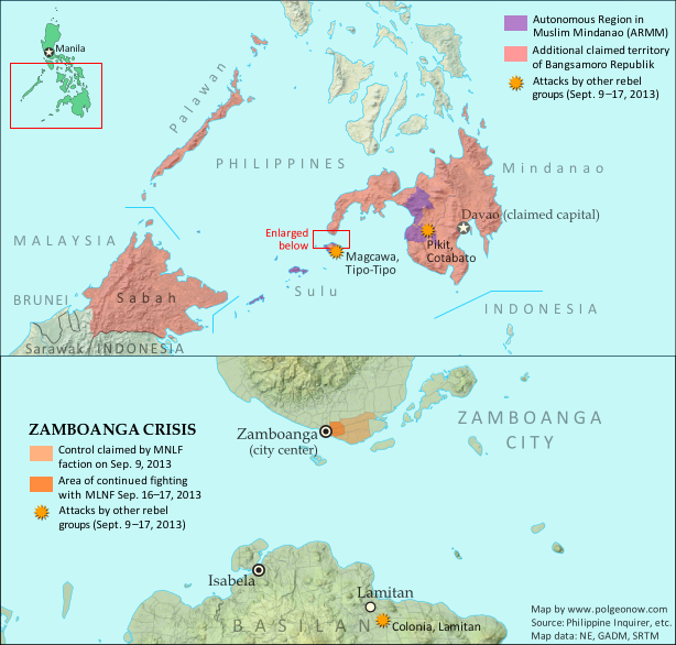
Map of territory in the Philippines and Malaysia claimed by the Bangsamoro Republik, plus territorial control by the Moro National Liberation Front (MNFL) during last month's Zamboanga crisis.
Claims and territorial control of the MNLF rebels and Bangsamoro Republik during last month’s crisis. Click to see full-sized map and article. Map by Evan Centanni.

Territory Retaken by Government
Last month, Political Geography Now mapped Moro rebel control in the Philippines’ Zamboanga crisis. The rebels, drawn from a group which had declared independence from the Philippines as the Bangsamoro Republik, had occupied several neighborhoods of Zamboanga City in the country’s southwest after an aborted attempt to raise their flag in the city center.

Ten days after we published that article, the government of the Philippines declared the crisis over, with all hostages freed and only scattered fighting occurring over the next two days as the surviving rebels attempted to escape the area. After nearly three weeks of chaos, the city of Zamboanga was once again fully under government control.

What of the MNLF fighters?
Though hundreds of rebels from the Moro National Liberation Front (MNLF) were killed in the fighting, some did escape, and the attack’s commander Habier Malik is still missing. Nur Misuari, the faction’s leader and founder of the self-declared Bangsamoro Republik, was not present at the attack but is now wanted on charges of rebellion. But he may have more than just the government to worry about – Malik’s surviving men from the Zamboanga attack are also said to be on the hunt for Misuari, who allegedly tricked them into participating. According to Mujiv Hataman, governor of the officially sanctioned Autonomous Region in Muslim Mindanao (ARMM), Misuari promised Malik’s men that U.N. peacekeepers would arrive soon after the attack to secure Bangsamoro independence and reward each fighter with 10,000 pesos (US $230) and a new weapon.

BIFF Attacks
Attacks by other Moro rebel groups in nearby regions continued until just after Zamboanga was secured. In particular, the Bangsamoro Islamic Freedom Fighters (BIFF), a splinter group from the Moro Islamic Liberation Fighters (MILF) who are currently in peace talks with the Philippine government, continued launching attacks elsewhere in Mindanao into early October. The BIFF is not closely tied to Nur Misuari’s MNLF, and these were apparently just opportunistic attacks taking advantage of the military’s distraction during the crisis in Zamboanga.

More information: Bangsamoro Republik? Philippine Separatists Seize Territory (map)

Central African Republic: Towns Retaken by Government-allied Forces (September 2013)

Map of control in the Central African Republic's anti-Seleka counter-rebellion, including towns of Bouca and Bossangoa
Counter-rebels briefly captured at least one Central African Republic town in September (click for full map and article). Map by Evan Centanni from this map by Wikimedia user Keitsist. License: CC BY-SA

Territory Nominally Reunited
Two weeks ago, Political Geography Now reported on rebel control in the Central African Republic’s new counter-rebellion. Since then, the towns of Bouca and Bossangoa have reportedly both been recaptured by forces belonging to Séléka, the former rebel coalition whose leader is now the president of the Central African Republic.

However, as outrage grows over vicious violence against civilians which has continued since Séléka’s campaign to take over the Central African Republic earlier this year, the new President Michel Djotodia has little actual control over the country.

One another analyst says that “law and order stops outside the presidential palace” in Bangui, and the AFP reported earlier this month that “A large number of [Séléka] fighters answer only to their direct leaders, who have carved out personal fiefdoms in the wake of the rebellion”. This raises serious questions regarding President Djotodia’s claims that he is now dissolving and outlawing the Séléka organization.

More information: Rebel Control Map: Central African Republic’s Counter-Rebellion

To see Séléka’s rise to power illustrated in rebel-control maps, view all Central African Republic articles.

Bangsamoro Republik? Philippine Separatists Seize Territory (map)

Zamboanga City in the southwestern Philippines came under rebel attack last week, with insurgents seizing and occupying several neighborhoods. Because the fighters are from a rebel group that declared independence in August, their newfound territorial control might technically be considered the birth of a new breakaway state. Details and discussion below!

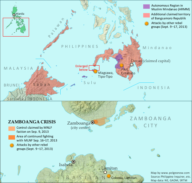
Map of territory in the Philippines and Malaysia claimed by the Bangsamoro Republik, plus territorial control by the Moro National Liberation Front (MNFL) as part of the Zamboanga crisis.
Claims and territorial control of the MNLF rebels/Bangsamoro Republik. Map by Evan Centanni.

Moro Rebellion
The southern Philippines is home to a long-running rebellion in the name of self-rule for the Moro people. The Moros are distinguished from other ethnic groups in the Philippines by their history as subjects of the Muslim kingdoms called sultanates, which ruled the southwestern islands until the late 1800s. Moro people today are typically Muslims, whereas the majority of Filipinos are Catholic.

Resistance to outside control of the southern Philippines goes back at least to the Moro Rebellion against U.S. occupation 100 years ago; but the modern insurgency began with Nur Misuari’s founding of the Moro National Liberation Front (MNLF) in 1969. After 20 years of fighting between the MNLF and the Philippine government, an agreement created the Autonomous Region of Muslim Mindanao (ARMM), and in 1996 the MNLF declared an end to the war. After that, a Moro-led insurgency continued, but at the hands of another group, the Moro Islamic Liberation Front (MILF).

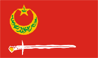
Flag of the Bangsamoro Republik and the Moro National Liberation Front (MNLF) rebels in the PhilippinesCountry Name:  
• Bangsamoro Republik
Official Name:  
• United Federated States of Bangsamoro Republik (UFSBR)
Capital: Davao City (claimed)

Bangsamoro Republik
Today the ARMM’s self-rule provisions still haven’t been fully implemented, and with the Philippine government in the process of arranging a separate peace agreement with the MILF, some MNLF members have become disillusioned with their own deal. Last month, a faction of the MNLF joined the organization’s original founder, Nur Misuari, in declaring an independent country called the Bangsamoro Republik.

“Bangsamoro” is a traditional name for the homeland of the Moro people, and the declaration of independence claimed the Mindanao, Sulu, and Palawan regions of the Philippines for the new country. Though the founders of the republic are Muslims, they’re not Islamists: the MNLF says Bangsamoro will be inclusive of all ethnic groups and religions in the region. But for all its talk of independence in August, the Bangsamoro Republik didn’t actually control any territory at all – until this week.

Battle for Zamboanga
Two weekends ago, unarmed MNLF members began arriving in the city of Zamboanga, outside the boundaries of the ARMM, for a planned demonstration against the Philippine government. But when armed fighters started landing in boats that Sunday night and Monday morning, allegedly with plans to raise the Bangsamoro flag in the city’s main square, they were engaged by the national military. The MNLF fighters, said to be from Misuari’s pro-independence faction, soon claimed to have seized seven neighborhoods of Zamboanga City from the government (though official statements put the number at only six).

The situation has since escalated into a drawn-out standoff, with the army reluctant to charge into the rebel-controlled areas for fear of harming civilians, who the rebels have taken hostage as human shields. But the Philippine military has gained some ground. By Sunday, the government claimed the rebels only remained in two neighborhoods, though fighting reportedly continued in at least three. On Monday the government announced that it had taken back 70% of the area the rebels controlled a week before. However, by Tuesday evening the story had changed, and officials were again acknowledging rebel control in pockets of five or six neighborhoods.

A Real Breakaway State?
Rebel control of these few neighborhoods might technically be considered the birth of the Bangsamoro Republik as a real breakaway state. The republic still isn’t recognized by any other countries, but since it now has both a declaration of independence and a territory under the control of its forces, it may qualify as a de facto sovereign state like Somaliland or Transnistria. In fact, Wikipedia editors have already added it to the encyclopedia’s list of sovereign states.

However, it seems unlikely the standoff will develop into any kind of long-term occupation under a rebel administration. What’s more, it’s actually not completely clear who the fighters are representing. As expected, leaders of MNLF factions other than Misuari’s, including the government of the ARMM, have condemned or distanced themselves from the attacks. But more surprising are claims by the mayor of Zamboanga City that Misuari himself, who led the declaration of independence, has denied sanctioning the attacks. Whether this is correct remains to be seen; other Philippine government and military figures continue to believe that Misuari is responsible. The leader of the rebel forces on the ground is Habier Malik, an MNLF commander with close ties to Misuari.

Claims to Malaysian Borneo

Flag of the PhilippinesCountry Name:  
• Philippines (English)
• Pilipinas (Filipino)
Official Name:  
• Republic of the Philippines (English)
• Republika ng Pilipinas (Filipino)
Capital: Manila

The MNLF’s website claims that the Bangsamoro breakaway state is to include not only regions of the Philippines, but also the Malaysian state of Sabah. Sabah was historically part of the Sultanate of Sulu, a Muslim kingdom based in the southwestern Philippines, and earlier this year was the scene of clashes with rebel forces claiming to represent the sultanate’s surviving royal family. Jamalul Kiram III, the leading contender for the throne of Sulu, argues that Sabah was only rented to Malaysia, and should still belong to his kingdom (and by extension to the Philippines).

Kiram’s position on the Bangsamoro Republik is that the breakaway state has no claim to Sabah, but that its declaration of independence is otherwise valid – however, he won’t support the creation of the state by military force. Meanwhile, Nur Misuari’s legal counsel has been quoted saying that even the neighboring Malaysian state of Sarawak is claimed by the Bangsamoro Republik. But this claim has not been confirmed by Misuari himself, and appears not to be supported by information on the MNLF’s website.

Basilan and Cotabato Attacks
Last week two additional battles began in Basilan province, an island located just across a narrow strait from Zamboanga. The attackers are also Moro fighters, but their actions are apparently not connected to the siege of Zamboanga – they might just be taking advantage of the distraction. Though some of the militants attacking Basilan’s Lamitan City are said to be members of the MNLF, most of them appear to be from Abu Sayyaf, a more extreme group known for its attacks on civilians and ties to international terrorist organization Al Qaeda.

Also last week, a separate attack was carried out in Cotabato province by the Bangsamoro Islamic Freedom Fighters (BIFF), another rebel group with no direct relation to the declared Bangsamoro Republik. Unlike the Bansamoro Republik’s MNLF rebels, both Abu Sayyaf and BIFF want to implement Islamic law  in the Moro homeland.

Followup article: Philippine Rebels Defeated

Related Articles
Is Palestine Really a Country?
New Country: Azawad Declares Independence from Mali
Rebel Control Map: Central African Republic’s Counter-Rebellion 

Graphic of the Bangsamoro Republik flag by Jaume Ollé/Wikimedia (CC BY-SA; source). Graphic of the flag of the Philippines is in the public domain (source).

Rebel Control Map: Central African Republic’s Counter-Rebellion (September 2013)

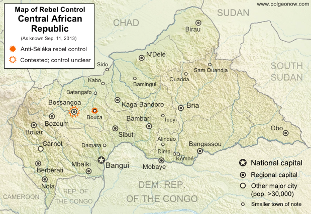
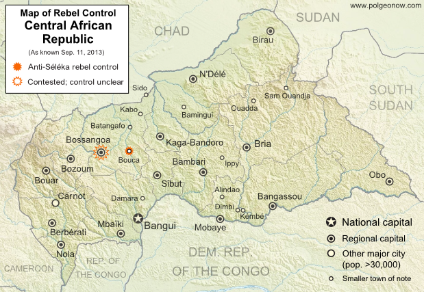
Map of 2013 counter-rebellion in the Central African Republic, showing current control by anti-Séléka (possibly pro-Bozizé) rebels as known on September 11, 2013.
Little sooner than Séléka rebel leader was sworn in as president, a new counter-rebellion has sprung up in the Central African Republic. Map by Evan Centanni from this map by Wikimedia user Keitsist. License: CC BY-SA

Previously: Séléka Coalition Takes Control of Central African Republic (Map of Rebel Advance)

Rebellion and Counter-Rebellion
Starting last December, a rebel coalition called Séléka swept across the Central African Republic from the north, capturing much of the country by January (see our first map of rebel control in the CAR). After a short-lived attempt at peace, Séléka renewed its campaign, capturing the capital and forcing President François Bozizé to flee the country. Rebel leader Michel Djotodia declared himself president, and Séléka has remained the major power in the country despite outbreaks of violence and general chaos.

Flag of the Central African RepublicCountry Name:  
• Central African Republic (English)
• Centrafrique (French)
• Bêafrîka (Sango)
Official Name:  
• Central African Republic (English)
• République centrafricaine (French)
• Ködörösêse tî Bêafrîka (Sango)
Capital: Bangui

Djotodia consolidated his power with an official presidential inauguration last month, but the conflict has proven to be far from settled. This Monday, heavy fighting broke out near Bossangoa, a city in the northwest, with anti-Séléka rebels reportedly taking over six unspecified towns in the area. Djotodia’s government said Bouca was one of the captured towns, while blaming the uprising on supporters of former president Bozizé.

The area is indeed Bozizé’s home region, though the rebels may not all be his supporters. A newspaper from Ghana reported that the rebels called themselves Anti-Balaka, which it translated as “Anti-Machete”. The same report also indicated that Bossangoa itself had fallen under rebel control, though other sources only state that fighting is ongoing in the surrounding villages as the city is being abandoned by fleeing civilians.

Stay tuned to Political Geography Now’s Central African Republic channel for updated maps of this evolving situation!

Related:
Syrian Civil War Control Map
Map of Nigeria’s War on Boko Haram
War in Somalia: Map of Al Shabaab Control

Graphic of the flag of the Central African Republic is in the public domain (source).