Bangsamoro Republik? Philippine Separatists Seize Territory (map)

Zamboanga City in the southwestern Philippines came under rebel attack last week, with insurgents seizing and occupying several neighborhoods. Because the fighters are from a rebel group that declared independence in August, their newfound territorial control might technically be considered the birth of a new breakaway state. Details and discussion below!
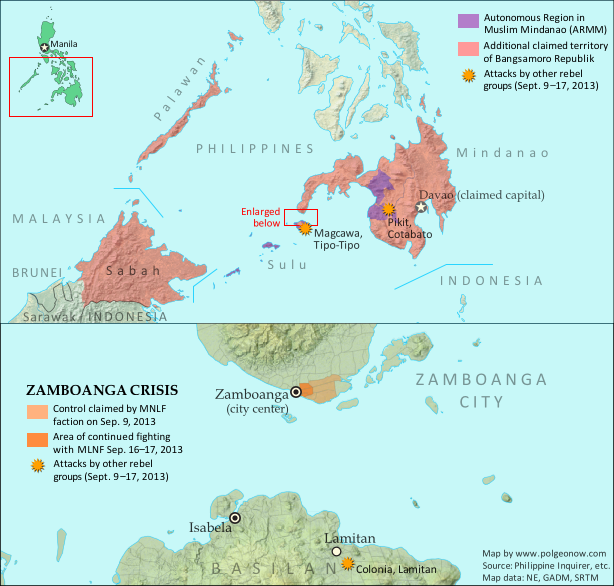
Map of territory in the Philippines and Malaysia claimed by the Bangsamoro Republik, plus territorial control by the Moro National Liberation Front (MNFL) as part of the Zamboanga crisis.
Claims and territorial control of the MNLF rebels/Bangsamoro Republik. Map by Evan Centanni.

Moro Rebellion
The southern Philippines is home to a long-running rebellion in the name of self-rule for the Moro people. The Moros are distinguished from other ethnic groups in the Philippines by their history as subjects of the Muslim kingdoms called sultanates, which ruled the southwestern islands until the late 1800s. Moro people today are typically Muslims, whereas the majority of Filipinos are Catholic.

Resistance to outside control of the southern Philippines goes back at least to the Moro Rebellion against U.S. occupation 100 years ago; but the modern insurgency began with Nur Misuari’s founding of the Moro National Liberation Front (MNLF) in 1969. After 20 years of fighting between the MNLF and the Philippine government, an agreement created the Autonomous Region of Muslim Mindanao (ARMM), and in 1996 the MNLF declared an end to the war. After that, a Moro-led insurgency continued, but at the hands of another group, the Moro Islamic Liberation Front (MILF).
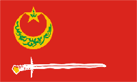
Flag of the Bangsamoro Republik and the Moro National Liberation Front (MNLF) rebels in the PhilippinesCountry Name:  
• Bangsamoro Republik
Official Name:  
• United Federated States of Bangsamoro Republik (UFSBR)
Capital: Davao City (claimed)

Bangsamoro Republik
Today the ARMM’s self-rule provisions still haven’t been fully implemented, and with the Philippine government in the process of arranging a separate peace agreement with the MILF, some MNLF members have become disillusioned with their own deal. Last month, a faction of the MNLF joined the organization’s original founder, Nur Misuari, in declaring an independent country called the Bangsamoro Republik.

“Bangsamoro” is a traditional name for the homeland of the Moro people, and the declaration of independence claimed the Mindanao, Sulu, and Palawan regions of the Philippines for the new country. Though the founders of the republic are Muslims, they’re not Islamists: the MNLF says Bangsamoro will be inclusive of all ethnic groups and religions in the region. But for all its talk of independence in August, the Bangsamoro Republik didn’t actually control any territory at all – until this week.

Battle for Zamboanga
Two weekends ago, unarmed MNLF members began arriving in the city of Zamboanga, outside the boundaries of the ARMM, for a planned demonstration against the Philippine government. But when armed fighters started landing in boats that Sunday night and Monday morning, allegedly with plans to raise the Bangsamoro flag in the city’s main square, they were engaged by the national military. The MNLF fighters, said to be from Misuari’s pro-independence faction, soon claimed to have seized seven neighborhoods of Zamboanga City from the government (though official statements put the number at only six).

The situation has since escalated into a drawn-out standoff, with the army reluctant to charge into the rebel-controlled areas for fear of harming civilians, who the rebels have taken hostage as human shields. But the Philippine military has gained some ground. By Sunday, the government claimed the rebels only remained in two neighborhoods, though fighting reportedly continued in at least three. On Monday the government announced that it had taken back 70% of the area the rebels controlled a week before. However, by Tuesday evening the story had changed, and officials were again acknowledging rebel control in pockets of five or six neighborhoods.

A Real Breakaway State?
Rebel control of these few neighborhoods might technically be considered the birth of the Bangsamoro Republik as a real breakaway state. The republic still isn’t recognized by any other countries, but since it now has both a declaration of independence and a territory under the control of its forces, it may qualify as a de facto sovereign state like Somaliland or Transnistria. In fact, Wikipedia editors have already added it to the encyclopedia’s list of sovereign states.

However, it seems unlikely the standoff will develop into any kind of long-term occupation under a rebel administration. What’s more, it’s actually not completely clear who the fighters are representing. As expected, leaders of MNLF factions other than Misuari’s, including the government of the ARMM, have condemned or distanced themselves from the attacks. But more surprising are claims by the mayor of Zamboanga City that Misuari himself, who led the declaration of independence, has denied sanctioning the attacks. Whether this is correct remains to be seen; other Philippine government and military figures continue to believe that Misuari is responsible. The leader of the rebel forces on the ground is Habier Malik, an MNLF commander with close ties to Misuari.

Claims to Malaysian Borneo
Flag of the PhilippinesCountry Name:  
• Philippines (English)
• Pilipinas (Filipino)
Official Name:  
• Republic of the Philippines (English)
• Republika ng Pilipinas (Filipino)
Capital: Manila

The MNLF’s website claims that the Bangsamoro breakaway state is to include not only regions of the Philippines, but also the Malaysian state of Sabah. Sabah was historically part of the Sultanate of Sulu, a Muslim kingdom based in the southwestern Philippines, and earlier this year was the scene of clashes with rebel forces claiming to represent the sultanate’s surviving royal family. Jamalul Kiram III, the leading contender for the throne of Sulu, argues that Sabah was only rented to Malaysia, and should still belong to his kingdom (and by extension to the Philippines).

Kiram’s position on the Bangsamoro Republik is that the breakaway state has no claim to Sabah, but that its declaration of independence is otherwise valid – however, he won’t support the creation of the state by military force. Meanwhile, Nur Misuari’s legal counsel has been quoted saying that even the neighboring Malaysian state of Sarawak is claimed by the Bangsamoro Republik. But this claim has not been confirmed by Misuari himself, and appears not to be supported by information on the MNLF’s website.

Basilan and Cotabato Attacks
Last week two additional battles began in Basilan province, an island located just across a narrow strait from Zamboanga. The attackers are also Moro fighters, but their actions are apparently not connected to the siege of Zamboanga – they might just be taking advantage of the distraction. Though some of the militants attacking Basilan’s Lamitan City are said to be members of the MNLF, most of them appear to be from Abu Sayyaf, a more extreme group known for its attacks on civilians and ties to international terrorist organization Al Qaeda.

Also last week, a separate attack was carried out in Cotabato province by the Bangsamoro Islamic Freedom Fighters (BIFF), another rebel group with no direct relation to the declared Bangsamoro Republik. Unlike the Bansamoro Republik’s MNLF rebels, both Abu Sayyaf and BIFF want to implement Islamic law  in the Moro homeland.

Followup article: Philippine Rebels Defeated

Related Articles
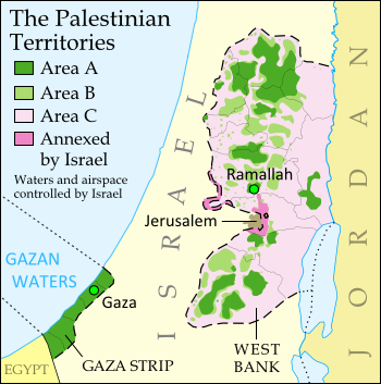
Is Palestine Really a Country?
New Country: Azawad Declares Independence from Mali
Rebel Control Map: Central African Republic’s Counter-Rebellion 

Graphic of the Bangsamoro Republik flag by Jaume Ollé/Wikimedia (CC BY-SA; source). Graphic of the flag of the Philippines is in the public domain (source).

Syria Civil War Map: August 2013 (#11)

There are newer versions of this map available. To see them, view all Syria updates.

Syria’s civil war has continued to rage through the summer, with small changes in territorial control and the area of fighting. Here’s the updated conflict map, plus a summary of recent territorial changes and other developments.

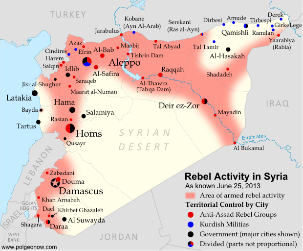
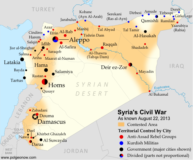
Map of fighting and territorial control in Syria's Civil War (Free Syrian Army rebels, Kurdish groups, Al-Nusra Front and others), updated for August 2013. Includes recent locations of conflict and territorial control changes, including Salma (Latakia), Nawa (Daraa), and Ras al-Ayn (Hasakah).
Area of fighting and territorial control in Syria’s civil war, updated for August 2013. Map by Evan Centanni, starting from this blank map by German Wikipedia user NordNordWest. License: CC BY-SA

Latest Fronts
Over the last two months since our previous Syria war map, fighting increased in three different corners of the country. In the northwest, rebels pushed farther into the coastal province of Latakia, a stronghold of President Bashar al-Assad and his native Alawite ethnic group. The rebel forces captured and briefly held several Alawite villages in the mountains before being pushed back to their base in Salma.

Meanwhile, fighting has heated up in the already contested Daraa province of southwestern Syria. Most notably, the rebels stormed the major town of Nawa in July, before losing it to the Syrian army again this month. In the country’s opposite corner, the far northeastern province of Hasakah, Kurdish militias finally seized full control of Serekani (Arabic name: Ras al-Ayn) from religious extremist rebels who had been fighting for the town since last year. Apparently in response, the extremists have pushed farther into Kurdish territory elsewhere in the province.

Flag of Syria under the current governmentCountry Name:  
• Syria (English)
• Sūriyya/Sūryā (Arabic)
Official Name:  
• Syrian Arab Republic (English)
• al-Jumhūriyyah al-‘Arabīyah  as-Sūriyyah (Arabic)
Capital: Damascus

Fighting in Major Cities
Syria’s three largest cities have remained battlefields over the past months, with number-one metropolis Aleppo still bitterly divided between the government, the rebels, and Kurdish groups. The Syrian army has made further inroads into Homs, and now controls most but not all of the key central city.

While central Damascus remains mostly out of reach for the rebels, fierce battles have continued to be waged over the capital city’s many suburbs (see a map of rebel and government control in the city from two weeks ago).

Broad Trends
An expert quoted in a New York Times article last month estimated that Syria’s rebel groups now control 60-70% of the country’s land, but only 40% of the population, due to their greater success at controlling rural areas than holding major cities.

Meanwhile, the opposition remains as disorganized as ever, having proved unable to form a national-level interim government for the rebel-held areas. But the starkest sign of disunity between the various anti-Assad groups has been the breakout of major fighting between the secular-minded Free Syrian Army (FSA) rebels and the religious extremists of the Nusra Front and the ISIS (“Islamic State of Iraq and Syria”). The latter groups have emerged as the strongest rebel force in many areas of Syria, driving the FSA out of Raqqah city as part of their rise in power across the country’s north and east.

Small Adjustments
This edition of the map returns to showing Ariha, a major town in Syria’s northwestern province of Idlib whose status had been unclear for many months. Recent reports indicate that it is divided between rebel and government control. In central Syria, the war has now reached the previously peaceful city of Salamiya, which was shelled by rebel forces two weeks ago.

Similar Articles:
Syria Civil War Map: June 2013 (#10)
Mali Conflict Map: National Territory Reunited
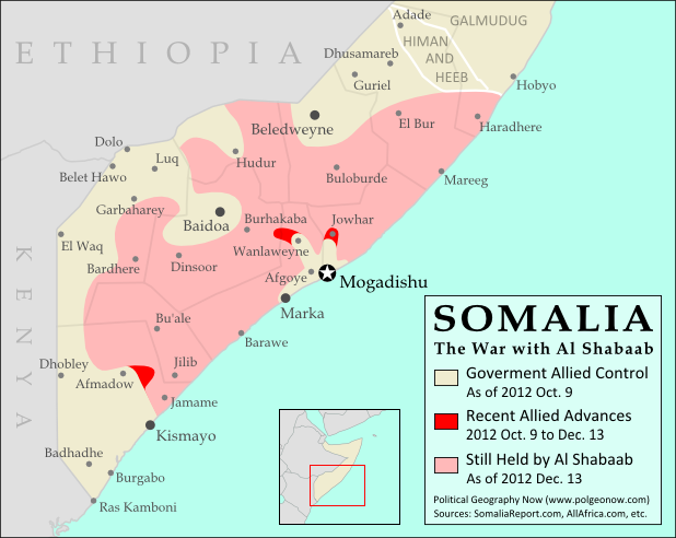
War in Somalia: Map of Al Shabaab Control

Graphic of the Syrian flag is in the public domain (source).

Japan-China Dispute: The Eight Islands of the Senkaku/Diaoyu Group (Aerial Photos)

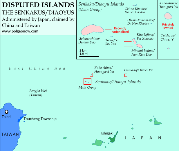
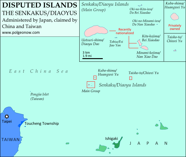
Map of the Senkaku/Diaoyu Islands, disputed between Japan, China, and Taiwan; includes location as well as detail of islands
Map of the disputed Senkaku/Diaoyu Islands (by Evan Centanni). Click to view at full size.

Article by Evan Centanni

The Senkaku/Diaoyu Islands
A recent feature on Political Geography Now introduced the history and status of the Senkaku/Diaoyu Islands, a disputed territory controlled by Japan but claimed by China and Taiwan. The article included an original map which showed the isles’ configuration and precise location within the East China Sea (click on the map at right to see it at full size). But if you’re like me, you may be wondering “just how small are these islands, and what do they really look like?”

Luckily for you and me, aerial photographs of many places in Japan have been released by the Japanese government and uploaded with English labels to Wikimedia Commons. Included in the collection are shots of each of the disputed isles, known as the Senkaku Islands to the Japanese, the Diaoyu Islands to the Chinese, and the Diaoyutai Isands to the Taiwanese. Here are the photos and a brief profile of each island:

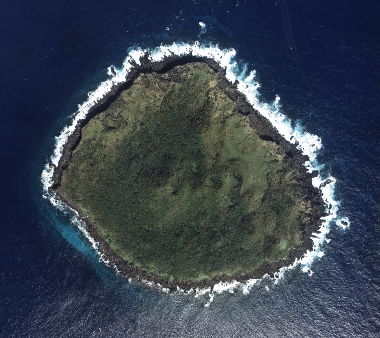
Aerial photo of Uotsuri-shima (魚釣島)/Diàoyúdǎo (钓鱼岛)/Diàoyútái (釣魚臺), the largest of the Senkaku/Diaoyu islands disputed between Japan, China, and Taiwan

Japanese: Uotsuri-shima (魚釣島)
Chinese (China): Diàoyúdǎo (钓鱼岛)
Chinese (Taiwan): Diàoyútái (釣魚臺)
Area: 4.32 km2 (1.67 mi2)
Highest Point: 383 m (1,257 ft.)
The largest isle in the disputed archipelago, Uotsori has been a center of historical activity in the Senkaku/Diaoyu Islands. It was the site of a Japanese fish-processing plant from about 1900-1940, when it hosted 200 workers. Since then it has been uninhabited, but was visited by a Japanese academic-governmental delegation for four weeks in 1979.

The island was one of four sold to the Kurihara family in the 1970s. The Japanese government rented the island from 2002, before finally buying it from the family last year. Though the island is no longer inhabited by humans, it is home to a population of domestic goats and albatross, as well as a species of mole found nowhere else on earth. Once called “Peaks Island” by the British, the current name means “Fishing Island” in both Japanese and Chinese (the name used by Taiwan is literally “Fishing Platform”). (photo source)

Aerial photo of Kita-kojima (北小島)/Běi Xiǎodǎo (北小島/北小岛) and Minami-kojima (南小島)/Nán Xiǎodǎo (南小島/南小岛), two major parts of the Senkaku/Diaoyu Islands disputed between Japan, China, and Taiwan

Japanese: Kita-kojima (北小島)
Chinese: Běi Xiǎodǎo (北小島/北小岛)
Area: 0.33 km2 (0.13 mi2)
Highest Point: 135 m (443 ft.)

Japanese: Minami-kojima (南小島)
Chinese: Nán Xiǎodǎo (南小島/南小岛)
Area: 0.46 km2 (0.18 mi2)
Highest Point: 149 m (489 ft.)
These are the only other major islands in the main cluster of the Senkakus. Like Uotsuri, they were sold to the Kurihara family in the 1970s, rented by the Japanese government from 2002, and bought by the government in 2012. The islands’ names are written the same in both Japanese and Chinese, and mean “Northern Little Island” and “Southern Little Island” respectively. (photo source

Aerial photo of Oki-no-Kita-iwa (沖の北岩)/Běiyǔ (北屿)/Chōng Běiyán (沖北岩)/Dà Běi Xiǎodǎo (大北小島)/Běiyán (北岩), group of rocks which form part of the Senkaku/Diaoyu Islands disputed between Japan, China, and Taiwan

Japanese: Oki-no-Kita-iwa (沖の北岩)
Chinese (China): Běiyǔ (北屿)
Chinese (Taiwan): Chōng Běiyán (沖北岩)
Other Chinese Names: Dà Běi Xiǎodǎo (大北小島), Běiyán (北岩)
Area: 0.02 km2 (0.01 mi2)
Highest Point: 28 m (92 ft.)
This is actually a small group of islets located in the northeast of the Senkaku Islands’ main cluster. It consists mainly of barren rocks, and has apparently never been privately owned. The Japanese and various Chinese names are variations on “Northern Islet” or “Northern Rock”; yet one name, Dà Běi Xiǎodǎo, means “Big Northern Little Island”, seeming ironically to imply that it outsizes the much larger Běi Xiǎodǎo (Kita-kojima). (photo source

Aerial photo of Oki-no-Minami-iwa (沖の南岩)/Nányǔ (南屿)/Chōng Nányán (沖南岩)/Dà Nán Xiǎodǎo (大南小島)/Nányán (南岩), group of rocks which form part of the Senkaku/Diaoyu Islands disputed between Japan, China, and Taiwan

Japanese: Oki-no-Minami-iwa (沖の南岩)
Chinese (China): Nányǔ (南屿)
Chinese (Taiwan): Chōng Nányán (沖南岩)
Other Chinese Names: Nán Běi Xiǎodǎo (大南小島), Nányán (南岩)
Area: 0.005 km2 (0.002 mi2)
Highest Point: 13 m (43 ft.)
Located at the eastern edge of the main cluster of the Senkaku Islands, this another barren rock which has apparently never been privately owned. Its names in Japanese and Chinese present it as the southern counterpart to Oki-no-Kita-iwa. (photo source)

Aerial photo of Tobise (飛瀬)/Fēiyǔ (飞屿)/Fēilài (飛瀨)/Fēiyán (飛岩)/Fēijiāoyán (飛礁岩), a reef which forms part of the Senkaku/Diaoyu Islands disputed between Japan, China, and Taiwan

Japanese: Tobise (飛瀬)
Chinese (China): Fēiyǔ (飞屿)
Chinese (Taiwan): Fēilài (飛瀨)
Other Chinese Names: Fēiyán (飛岩), Fēijiāoyán (飛礁岩)
Area: 0.0008 km2 (0.0003 mi2)
Highest Point: 2 m (7 ft.)
Tobise is a cluster of rocks located just southeast of Uotsuri, the biggest island of the Senkakus. Although the area of shallow water surrounding it gives it a larger profile on some maps, according to the Taiwan government’s measurements it is the smallest of the eight major named isles of the Senkaku/Diaoyu Islands. It is also the lowest, protruding little farther above the water than the height of a person. Its Japanese and Chinese names all translate to something like “flying shoals” or “flying reef”. (photo source)

Aerial photo of Kuba-shima (久場島)/Huángwěiyǔ (黃尾嶼/黄尾屿), one of the Senkaku/Diaoyu Islands disputed between Japan, China, and Taiwan

Japanese: Kuba-shima (久場島)
Chinese: Huángwěiyǔ (黃尾嶼/黄尾屿)
Area: 1.08 km2 (0.42 mi2)
Highest Point: 117 m (384 ft.) Kuba is the second largest of the Senkaku Islands, located to the north of the main cluster. In the 1970s, it was sold to the Kurihara family along with the three major islands of the main group, but was owned by the sister of the man who the other three belonged to. Today it is still owned by the family, but rented by Japan’s Ministry of Defense. The Japanese in turn allow the U.S. military to use it as a practice bombing range for aircraft. “Kuba” is a Japanese surname, and the Chinese name means “Yellow-tail Islet”. (photo source)

Aerial photo of Taishō-to (大正島)/Chìwěiyǔ (赤尾嶼/赤尾屿), one of the Senkaku/Diaoyu Islands disputed between Japan, China, and Taiwan

Japanese: Taishō-to (大正島)
Chinese: Chìwěiyǔ (赤尾嶼/赤尾屿)
Area: 0.06 km2 (0.02 mi2)
Highest Point: 75 m (246 ft.)
Taisho is the most distant of the Senkaku/Diaoyu Islands, located over 100 km (60 mi) to the east of the main group. A relatively high island for its size, it has been continuously owned by the Japanese government since Japan formally took possession of the islands in 1895. In Japanese, the island is probably named after Emperor Taishō, the Emperor of Japan at the time when the Senkakus were annexed and developed. The Chinese name means “Red-tail Islet”. (photo source)

(Photos from Wikimedia Commons, based on National Land Image Information (Color Aerial Photographs), Ministry of Land, Infrastructure, Transport and Tourism of Japan. Used under terms of copyright.)

Related Articles:

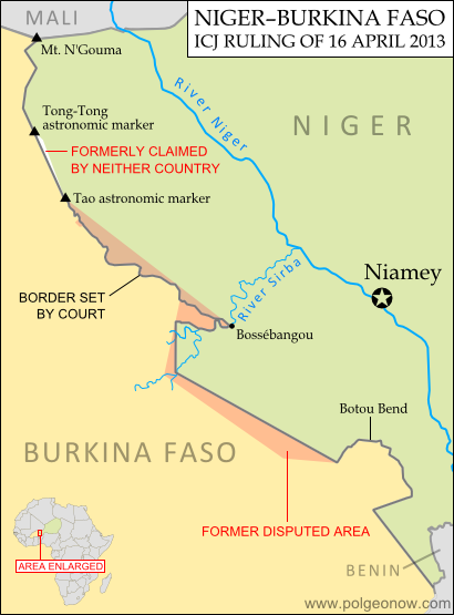
Niger and Burkina Faso Resolve Territorial Dispute

Syria Civil War Map: June 2013 (#10)

There are newer versions of this map available. To see them, view all Syria updates.

Since March, large-scale violence has continued in Syria. Despite this, no major cities have changed hands – yet there have been important changes to control of smaller towns in two different regions. Here’s the updated conflict map, plus a summary of recent territorial changes.

Map of rebel activity and control in Syria's Civil War (Free Syrian Army, Kurdish groups, Al-Nusra Front and others), updated for June 2013. Includes recent locations of conflict and violence, including the Qusayr, Golan Heights, Daraa, Dael, and Baida.
Activity and cities held by rebels and other groups in Syria, updated for June 2013. Map by Evan Centanni, starting from this blank map by German Wikipedia user NordNordWest. License: CC BY-SA

Golan Heights Fighting
Soon after our last update, rebel groups continued making small gains in Syria’s far southeast. In mid-March, they captured a military intelligence compound in the town of Shagara, and three days later the same group seized the town of Khan Arnabeh a bit to the north. Both towns lie close to the Golan Heights, a disputed territory controlled by Israel.

A narrow strip of land on the Syrian side of the Golan Heights ceasefire line has been demilitarized under the protection of U.N. peacekeepers since 1973, but even this area has seen fighting since late last year. Rebels in the zone briefly took control of the border crossing with Israel early this month, part of a series of events that has put the peacekeeping mission’s future in jeopardy.

Rebel Gains in Daraa
Soon after taking Khan Arnabeh, the same rebel group achieved yet another major victory: the capture of a major air defense base just east of the southern Syrian city of Daraa. Soon they and other rebel groups had effective control of all border crossings with Jordan.

By the end of the month, rebel forces were also in control of Dael, an important town north of Daraa city. It was only in May that the Syrian army began getting its foothold back outside of Daraa, seizing the town of Khirbet Gazaleh near Dael.

Flag of Syria under the current governmentCountry Name:  
• Syria (English)
• Sūriyya/Sūryā (Arabic)
Official Name:  
• Syrian Arab Republic (English)
• al-Jumhūriyyah al-‘Arabīyah  as-Sūriyyah (Arabic)
Capital: Damascus

Government Takes Qusayr
The more important change in control came early this month, when the Syrian government and allied forces captured Qusayr after a long and difficult battle. Qusayr is a strategic town between the city of Homs and the border with Lebanon, and saw prolonged fighting earlier in the war before coming under rebel control a year ago. Since Qusayr’s recapture, other nearby towns have also been seized by the government.

Hezbollah and Lebanon
In the battle for Qusayr, Syria’s army received major military support from Hezbollah, a Shiite militia from Lebanon which has long supported President Bashar al-Assad. After that victory, Hezbollah has become more overtly involved in the fighting within Syria. Meanwhile, Lebanon is being slowly dragged into its neighbor’s civil war, with one Lebanese town even coming under attack from the Syrian military two weeks ago.

Battles Continue in Major Cities
Syria’s biggest population centers continue to be centers of intense fighting as well, with Aleppo still divided between multiple groups (see a collaborative map of control) and once-rebel-dominated Homs now reportedly 80% government-controlled. At the same time, the capital city of Damascus continues to see heavy back and forth fighting in its suburbs, and in recent months rebels have even begun moving into the city itself.

Activity on the Coast
Last month, the town of Bayda near Syria’s Mediterranean coast became infamous for a brutal massacre committed by government or allied forces against Sunni civilians, some of whom had been rebel sympathizers (rebels were also accused of a sectarian massacre in a few weeks later). The Bayda massacre was reportedly a response to an attack by local rebels on a bus carrying pro-government militiamen, a rare and possibly unprecedented instance of armed rebel activity Syria’s coastal region. This area, which is the traditional homeland of President Assad’s minority Alawite sect, has been so far spared from rebel-on-army fighting, though it has been the scene of unarmed protests violently suppressed by the government.

Adjustments to the Map
Two adjustments have been made to the Syria control map in this update which do not necessarily reflect actual changes to the situation since last time. First, the city of Hama has been colored all black rather than black and red, to reflect the fact that there has recently been little evidence of significant rebel control within the city (however, back-and-forth fighting continues outside the city in Hama province).

The second adjustment is to Zabadani, in the mountains between Damascus and the border with Lebanon. This town has been contested since early in the war, sometimes falling under rebel control and other times to the government. The most recent information suggests that rebels have nearly complete control of the town itself, despite being surrounded by government forces.

Related Articles:

Graphic of the Syrian flag is in the public domain (source).

Disputed Territory: The Senkaku/Diaoyu Islands

You may have heard the news about China and Japan’s ongoing territorial dispute over a group of islands in the East China Sea. But what are the Senkaku/Diaoyu Islands, and why are they so fiercely contested? Read on for all these answers and more!

Map of the Senkaku/Diaoyu Islands, disputed between Japan, China, and Taiwan; includes location as well as detail of islands
Map of the disputed Senkaku/Diaoyu Islands (by Evan Centanni).

Article by Omar Alkhalili

About the Islands
The Senkaku/Diaoyu Islands are a collection of five small islets and three rocks in the East China Sea, all of which are uninhabited. The largest of the islands has an area of 4.32 km² and the smallest is only 0.45 km². They are located about 140 km from the nearest inhabited Japanese islands, 300 km from mainland China and 170 km from Taiwan. They are administered by Japan but claimed by both the People’s Republic of China (PRC) and Taiwan, whose government is known officially as the Republic of China (ROC).

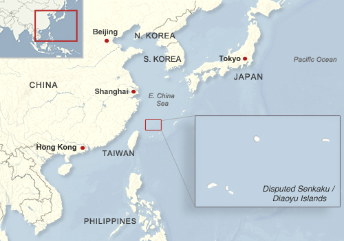
Map of the location of the disputed Senkaku/Diaoyu Islands within Asia
Location of the disputed Senkaku/Diaoyu Islands in Asia
Public domain graphic (source)

In English, the islets have historically been referred to as the Pinnacle Islands, but are now more often called by their Japanese and Chinese names. In Japan, they are known as the Senkaku Islands, whereas in mainland China they are called the Diaoyu Islands and in Taiwan they are referred to as the Diaoyutai (Tiaoyutai) Islands. They are administered by Japan as part of Ishigaki, a municipality in Okinawa Prefecture, while the PRC and ROC both consider them part of Toucheng township in Taiwan’s Yilan County, despite the fact that the two rival governments do not recognize each other.

While it considers the islands part of Ishigaki, Japan’s central government does not allow the city to develop or survey them. Four of the islands have been privately owned since 1932, but the government bought three of them last year after renting them for some time. One of the privately owned islands is still leased to the Japanese Ministry of Defense, which has allowed the United States military to use it as a practice bombing range for aircraft.

History of Claims and Control

Territory Name:  
Senkaku-shotō (Japanese)
• Diàoyúdǎo (Mandarin – China)
• Diàoyútái (Mandarin – Taiwan)
Pinnacle Islands (English – historical) 
Claimants: 
• Japan
• China (People’s Republic of China)
• Taiwan (Republic of China)
Actual Control: Japan
Administrative Status: Part of the country
Capital: N/A (uninhabited)

Japan, mainland China and Taiwan all root their claims to the Senkakus/Diaoyus in the region’s history. China was aware of the islands’ existence since the 15th century, and the PRC and ROC claim that the islands have been part of Chinese territory since at least the 16th century. However, the Japanese government holds that when it surveyed the islands in the late 1800s, they were uninhabited and showed no signs of having been under Chinese administration.

Japan took control of the islands in 1895, and with the exception of the American occupation of Japan from 1945 to 1972, has held onto them ever since. Both Chinas now consider the islands to be part of Taiwan province, which China ceded to Japan in 1895 after the First Sino-Japanese War. However, they hold that Japan returned the rights to the islands to China by surrendering to the Allied Powers at the end of World War II. Japan insists that these islands were not part of the territory that it gave up in surrendering, arguing that they were always considered part of the Ryukyu island chain rather than Taiwan. China and Taiwan did not voice their claim to the Senkaku/Diaoyu islands until after the U.S. occupation Okinawa ended in 1972.

On top of the historical claims, various economic issues complicate the dispute. The islands’ territorial waters include rich fishing grounds and lie along the path of strategically important shipping lanes. Potential oil reserves have also been identified nearby.

Current Dispute
In recent years, tensions over the Senkaku/Diaoyu Islands have flared between Japan and both Chinese governments. After a series of incidents in 1996 that included Japanese activists installing a light house on one of the islands and the death of a Chinese activist due to drowning, there have been continued instances of Chinese activists attempting to sail to the islands, resulting in their arrest and detention.

Aerial view of two of the Senkaku/Diaoyu Islands disputed between Japan, China, and Taiwan
Aerial photo of Kita-kojima/Bei Xiaodao and Minami-kojima/Nan Xiaodao in the Senkaku/Diaoyu Islands
(Courtesy of Japan National Land Image Information (Color Aerial Photographs, Ministry of Land, Infrastructure, Transport and Tourism; source)

In 2010, an incident involving the detention of a Chinese ship crew precipitated mass protests in Chinese cities. Two years later, before the Japanese government’s purchase of three of the islands, the then Governor of Tokyo came up with his own plan to buy the islands, sparking protests in China and resulting in the detention of a group of activists from Hong Kong. Mainland China has challenged Japanese control of the islands through incursions into their territorial waters and airspace. In 2013, the mainland government announced that it plans to survey the islands in order to safeguard its maritime interests.

Recently, some progress has been made in resolving the dispute, with Japan and Taiwan arriving at an agreement allowing Taiwanese fishermen access to a large portion of the island’s surrounding waters. This agreement may create an obstacle for mainland China as its government becomes isolated in its efforts to challenge Japanese control. However, Taiwan still retains its claims to the Senkakus/Diaoyus, and there is no clear end in sight for the dispute between the three governments.

Omar Alkhalili is a contributor to Political Geography Now. He is a graduate of Ramapo College of New Jersey with a Bachelor of Arts Degree in Political Science. He can be reached at omaralkha@gmail.com.

See Also: The Eight Islands of the Senkaku/Diaoyu Group (profiles and aerial photos)

Related Articles:

Niger and Burkina Faso Resolve Territorial Dispute

Who Recognizes Palestine in 2013?

(Keep up with changes to Palestine’s situation: view all Palestine updates.)

 Palestine is now an Observer State in the U.N., but it’s still not recognized individually by all U.N. member countries. Read on for more about the latest countries to recognize Palestine, plus other recent changes to its international status.

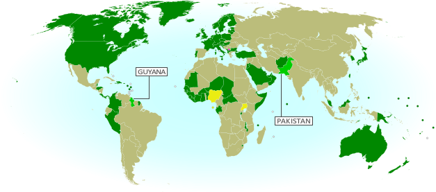
Map of countries that recognize the State of Palestine as an independent country, updated for May 2013 with most recent additions highlighted
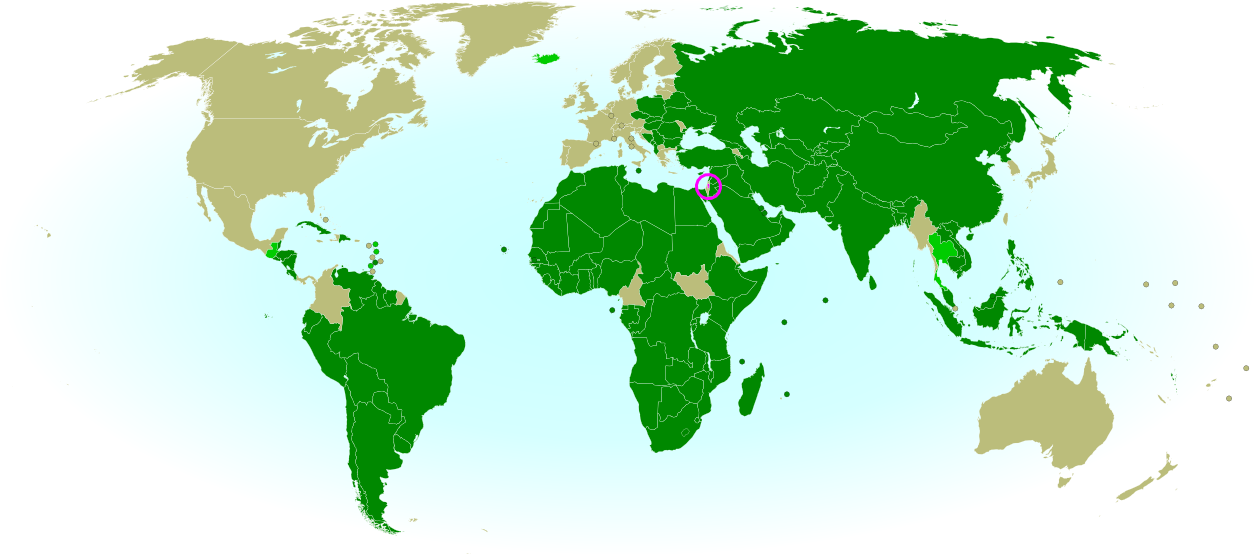
Countries recognizing the State of Palestine in green, with most recent additions highlighted in lighter green. Palestine in magenta (circled). Map by Evan Centanni, modified from public domain graphic (source).


By Evan Centanni

Countries that Recognize the State of Palestine
Despite opposition from Israel, the U.S., and other Western countries, Palestine was recognized as an Observer State by the U.N. last year. However, recognition by individual countries is a separate matter. In September of 2011 we reported that the declared State of Palestine had accumulated recognition from 126 U.N. members plus partially-recognized Western Sahara. But have more states recognized Palestine as an independent country since then?

Yes, a few. As highlighted on the map above, several more U.N. member countries have recognized the State of Palestine over the last year and a half. New additions since our previous update are the Caribbean island nations of Dominica, Antigua and Barbuda, and Grenada, plus Thailand in Southeast Asia and Iceland in Europe. The latest, recognizing Palestine for the first time just last month, is the Central American state of Guatemala.

Flag of Palestine Country Name:  
• Palestine (English)
Filasṭīn (Arabic)
Official Name:  
• State of Palestine (English)
• Dawlat Filasṭin (Arabic)
Capital: 
• Jerusalem (claimed)
Ramallah (administrative)

This brings the total number of U.N. members that consider Palestine a sovereign state to 132, or about 68 percent. Or could it be more? Last year, before Guatemala’s announcement, the Palestinian government was already claiming recognition from 132 countries, and the U.N. resolution which made it an Observer State mention that Palestine was already recognized by 132 “members of the United Nations”. However, no additional recognitions have emerged in the months since then, so it seems likely that it was an error. The number 132 probably refers to the 131 U.N. members recognizing at the time, plus Western Sahara.

Wikipedia: List of countries recognizing Palestine

Palestine in UNESCO
Also since our September 2011 report, Palestine was accepted as a member of the United Nations Educational, Scientific and Cultural Organization (UNESCO), a specialized agency of the U.N. This happened before its elevation to Observer State status in the General Assembly, and was quite controversial at the time. It was speculated that becoming an Observer State would increase the likelihood of Palestine being accepted into more U.N. organizations in the future – however, this has not yet happened.

Change of Standard ISO Name
Another change to Palestine’s treatment internationally came with a February 2013 update to the standard list of country codes and names from the International Organization for Standardization (ISO). This standard, which is used by many organizations and companies around the world, is tied to official United Nations usage. After the Palestinian government received Observer State status from the U.N., its name was changed in the standard from “the Occupied Palestinian Territory” to “the State of Palestine”.

Online company Google caused a bit of a stir last week when it changed the name of its Palestinian search page from “Palestinian Territories” to “Palestine”, receiving criticism from the Israeli government. However, Google argued that it was not making a political statement, but only following the lead of the U.N. and the standard used by websites around the world.

Check For Updates: See more recent recognition reports by viewing all Palestine posts.

Related Articles:

Is Palestine Really a Country?

What is North Korea?

North Korea’s threats of war have captured the world’s attention in recent weeks, leaving citizens of other East Asian countries anxiously awaiting the latest news. A new war is unlikely, but how much do you know about North Korea, its international status, and its dispute with the south?

Map of North Korea and South Korea
Map by Johannes Barre & Patrick Mannion (CC BY-SA) (source)

What is North Korea?
Located on the northern half of the Korean Peninsula between South Korea and China (and sharing a short border with Russia), North Korea is a medium-sized East Asian country of about 24 million people. Despite its size, it boasts the fourth-largest army in the world, and has remained officially at war with South Korea since 1950.

Sometimes considered one of the world’s last remaining communist states, North Korea actually claims no longer to follow communist ideology. However, it surely does hold the distinction of having the world’s most closed borders, with its totalitarian government tightly controlling the flow of information and people in and out of the country.

What territory does North Korea claim?
North Korea doesn’t actually have “north” in its official name, which is the Democratic People’s Republic of Korea (DPRK). This is because it claims to be the rightful government of all of Korea, including the south. South Korea (officially the Republic of Korea) also maintains the same claim, with both sides seeking eventual unification. Korea hasn’t been a single independent country for over 100 years, since it lost its independence in 1905 and was absorbed into the Japanese Empire in 1910.

How did Korea become divided?

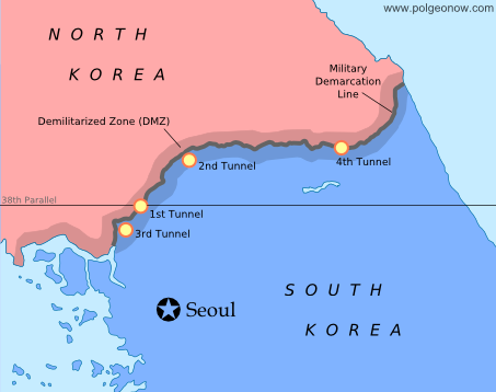
Map of the Military Delimitation Line (armistice line) and Demilitarized Zone (DMZ) separating North and South Korea
Armistice line and DMZ dividing North and South Korea. Modified by Evan Centanni from this map by Rishabh Tatiraju (CC BY-SA).

When Japan lost World War II in 1945, Korea was divided temporarily between U.S. and Russian control, with the boundary placed arbitrarily at the latitude 38° north. However, the Russian-held area in the north and the U.S.-held area in the south ended up forming two rival governments, a political situation that culminated with the north’s 1950 invasion of the south.

In the first large-scale conflict of the Cold War, an American-led U.N. intervention force fought off the Russian- and Chinese-supported north in the three-year-long Korean War. The armistice that brought fighting to an end in 1953 drew a new boundary close to the old one, but not as straight, also establishing a 4 km (2.5 mi) wide Demilitarized Zone (DMZ) around the line. However, because both Koreas seek reunification, neither recognizes the armistice line as an official border.

Map of North and South Korea's differing claims for their maritime boundary in the Yellow Sea
Korean boundary in the Yellow Sea: the U.N.’s Northern Limit Line (A) and North Korea’s claimed line (B). Map modified by Evan Centanni from this one by Amble, 玖巧仔 and Tomchen1989 (CC BY-SA).

Are there any other “disputed territories” between North and South Korea?
Yes – although technically the entire Korean peninsula is disputed between the north and the south, even the unofficial boundary is contested in the Yellow Sea off Korea’s west coast. The armistice agreement didn’t specify a sea boundary, and U.N. forces later drew a simple line running between North Korea and the nearest South Korean islands (the Northern Limit Line). However, North Korea has rejected this boundary, drawing its own line to carefully avoid the South’s islands while claiming the surrounding waters for itself.

What is North Korea’s international status?
Despite North Korea and South Korea claiming to represent the same larger Korea, they are both members of the U.N., after being admitted at the same time as Cold War politics were thawing in 1991. North Korea is now acknowledged around the world as an independent country, with only South Korea and Japan refusing to recognize it. Meanwhile, North Korea maintains active diplomatic relations with most of the world’s countries, with a few major exceptions, such as the U.S. and France.

Flag of North Korea (Democratic People's Republic of KoreaCountry Name:  
• North Korea (English)
• Chosŏn (Korean)
Official Name:  
• Democratic People’s Republic of Korea (English)
• Chosŏn Minjujuŭi Inmin Konghwaguk (Korean)
Capital: Pyongyang

Article by Evan Centanni

Syria Uprising Map: March 2013 (#9)

There are newer versions of this map available. To see them, view all Syria updates.

Syria’s civil war has continued to spread eastward across the country, with rebels taking two major towns over the last month. Below is the updated conflict map, plus a summary of recent territorial changes.

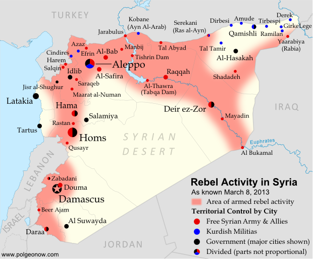
Map of rebel activity and control in Syria's Civil War (Free Syrian Army, Kurdish groups, Al-Nusra Front and others), updated for March 2013. Includes recent locations of conflict, including Raqqa, Al-Safira, Al-Hasakah, and Tabqa Dam.
Activity and cities held by rebels and other groups in Syria, updated for March 2013. Map by Evan Centanni, starting from this blank map by German Wikipedia user NordNordWest. License: CC BY-SA

Eastward to Raqqah
Since our last Syria map update, rebel forces have continued to move southeast from Aleppo (where fighting still rages), last month taking over the Tabqa hydroelectric dam. It was soon reported that they controlled the neighboring town of Thawrah as well. (“Tabqa” and “Thawrah” are actually two names for the same place; the latter is a more recent official name which means “revolution” in Arabic).

This week, the rebels reached Raqqah, apparently seizing nearly the whole city and capturing the provincial governor. This gives them almost complete control of an entire province, and is the first time they have held a provincial capital since losing Idlib city a year ago. It also effectively connects the two fronts of the war, with rebels now mostly in control of a stretch running all the way from Aleppo in the northwest to Al Bukamal in the southeast.

Flag of Syria under the current governmentCountry Name:  
• Syria (English)
• Sūriyya/Sūryā (Arabic)
Official Name:  
• Syrian Arab Republic (English)
• al-Jumhūriyyah al-‘Arabīyah  as-Sūriyyah (Arabic)
Capital: Damascus

Rebel and Kurdish Groups in the Northeast
Even as rebel forces moved east from Aleppo, another group struck out northwest from the Deir ez-Zor area, taking over the town of Shadadeh in Al-Hasakah province. This northeasternmost province is a major oil-producing region, but further conquests may come up against resistance from Kurdish militias, whose people form a large percentage of the population.

Indeed, Kurdish groups have continued to consolidate their power in Syria’s far northeast, seizing the town of Ramilan this week, and reportedly occupying most of Al-Hasakah’s oil fields. The Kurdish militias are not officially aligned with either side in the war, usually claiming to oppose the government, but keeping a wary eye on the rebels at the same time.

Last weekend, another battle was going on quite close to Ramilan. In what became a small international incident, rebels fought government forces for control of the northeastern border crossing to Iraq. According to some reports, the rebels gained control of Yaarabiya, the town on the Syrian side of the border; the crossing is also known as Rabia, after the town on the Iraqi side.

Fighting in Syria’s West
Also last month, rebels moved into Al-Safira, a major town just outside of Aleppo. They were soon reported to control of the streets, though fighting was ongoing against government forces just outside the town. In December, just after our last map update, there was also a major campaign near Hama, in which rebels took control of various small towns and villages north of the city, but lost several of them again within a few weeks.

The Al-Nusra Front
It is worth mentioning that rebel victories in Syria’s civil war have increasingly been attributed not to the Free Syrian Army, but to its ally the Al-Nusra Front (also known as Jabhat al-Nusra). This militant group, known for a long list of bombings as well as battles, is made up of religious fundamentalists who envision an Islamic state to replace the current Syrian government. The Al-Nusra Front has played a leading role in Al-Safira and Shadadeh in particular, succeeding partly through the skills of well-trained foreign fighters from other Arab countries like Libya, Iraq, and Saudi Arabia. It is suspected of ties with Al Qaeda.

Related Articles:

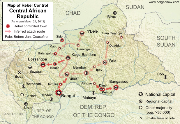
Central African Republic: Map of Rebel Advance to Capital

Graphic of Syrian flag is in the public domain (source).

Map: Laos and Tajikistan Join WTO

Map of World Trade Organization (WTO) member countries, updated for March 2013 to include new members Laos and Tajikistan
World Trade Organization members in green. New members Laos and Tajikistan highlighted (click to enlarge). Map by Evan Centanni, modified from this Wikimedia map by Muso (license: CC BY-SA).

Logo of the World Trade Organization (WTO) Organization Name:  
• World Trade Organization (English)
• Organisation mondiale du commerce (French)
• Organización Mundial del Comercio (Spanish)
Founded: 1994 in Marrakech, Morocco (commenced in 1995)
Headquarters: Geneva, Switzerland
Website: www.wto.org

World Trade Organization Continues Growing
The World Trade Organization (WTO), a global treaty-based organization formed in 1995 to manage and promote international trade, has admitted two new members in recent weeks. This follows the previous admission of four new members last year (which had been approved at the end of 2011).

Laos, a landlocked communist state in Southeast Asia, was approved for membership last October, after 15 years of unsuccessful efforts to join. The country, whose economy is very small but growing rapidly, officially became a member of the WTO on February 2nd. Laos was the last mainland Southeast Asian country to join the organization, meaning the entire region is now represented in the global body.

Tajikistan, a former soviet country in Central Asia, joined the WTO last weekend (March 2nd) after a 12-year-long campaign. The small country, which is also landlocked like Laos, was approved for membership in December. It is the second of the five ex-soviet Central Asian countries to join the organization, after Kyrgyzstan.

The World Trade Organization now has 159 members, including about 80% of the world’s countries, plus a few which are not independent countries, such as Hong Kong and the European Union (each of the EU’s members also has its own separate membership).

WTO logo is displayed without permission, based on fair use principles (source).

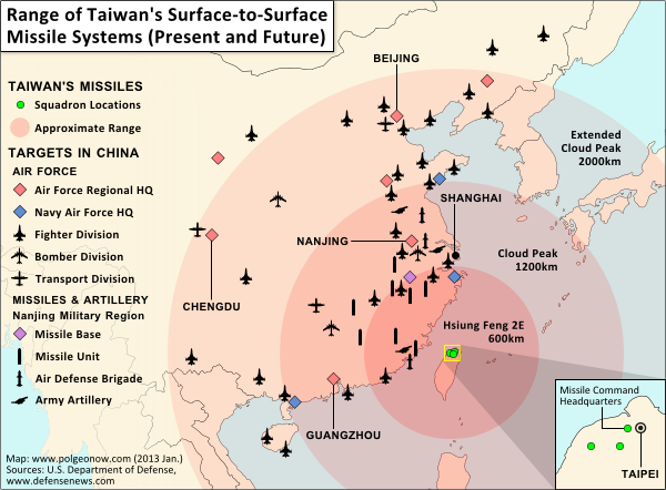
Partner Project: Range of Taiwan’s Missiles

Map of Taiwan's missile capabilities, created for Taiwan in Perspective (https://michalthim.wordpress.com)
Click to see at full size on Taiwan in Perspective blog.
Map by Evan Centanni (all rights reserved).

Michal Thim from Taiwan in Perspective recently asked Political Geography Now to help him make a map depicting Taiwan’s current and future missile capabilities in its standoff with China. For anyone who’s interested, here’s the finished product (click on the map to see it at full size on Michal’s site). The main sources for the missile information was this article from Defense News, and the locations of China’s military assets come from the U.S. Department of Defense’s 2012 annual report on China.

If you want to learn more about the complex political situation in Taiwan, Wikipedia has a decent outline of the basics. Political Geography Now also hopes to publish maps and articles covering Taiwan in the future.