Syria Civil War: Territorial Control Map #12.3 (Premium)

There are newer versions of this map available. To see them, view all Syria updates.

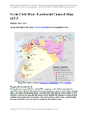
Detailed map of fighting and territorial control in Syria's Civil War (Free Syrian Army and Nusra Front rebels, Kurdish groups, ISIS/ISIL/Islamic State and others), updated to July 3, 2014.

Download PDF
buy

(Subscribe via Paypal to view all premium content online)

This is the Syria update you’ve been waiting for: our new map includes not only cities, but a full illustration of territorial control for each faction in the civil war. Also includes many updates to the situation since the last edition in April.

This map and article are exclusive premium content, available to paid subscribers or for individual purchase.
Buy now (US$9.99)

Premium map includes:

  • Up-to-date map of current territorial control in Syria, color-coded for the Assad government, rebel groups, ISIS/Islamic State extremists, and Kurdish self-protection forces
  • Detailed indication of city-by-city control, highlighting key towns relevant to current events
  • Includes recent areas of fighting including Deir ez-Zor, Abu Kamal, Mayadin, Khan Shaykhun, and many more
  • In-depth article summarizes changes since April, including ISIS’s declaration of an Islamic caliphate, with links to the sources of information

Members click here to proceed to article and map

Not a member yet? Subscribe Now!

Iraq’s New War: Detailed Map of ISIS Takeover (Premium)

There are newer versions of this map available. To see them, view all Iraq updates.

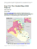
Detailed map of territorial control in Iraq in June 2014, including cities and countryside held by the Islamic State of Iraq and al-Sham (ISIS, ISIL) and the Kurdistan Peshmerga.

Download PDF
buy

(Subscribe via Paypal to view all premium content online)

Since our last Iraq map update less than a month ago, the conflict has blown up with a spectacularly successful offensive by ISIS rebels. PolGeoNow presents here our updated map of territorial control in Iraq, more detailed and accurate than any of the maps available on news websites.

This map and article are exclusive premium content, available only to members or for individual purchase.

 Buy now (US$9.99).

 Premium map includes:

  • Territorial control in Iraq by city, color coded for government, ISIS, or Kurdistan Government
  • Detail of ISIS control and attempted control of small towns, military bases, and border crossings
  • Inset map with extra detail for Kirkuk province, where ISIS and Kurdish forces are facing off
  • Shading showing the estimated total area of ISIS control
  • Article summarizing events since May, explaining the information on the map, and providing in-line links to sources cited

Members click here to proceed to article and map

Not a member yet? Subscribe Now!

Palestine: West Bank and Gaza Reunited Under Transitional Government

(Keep up with changes to Palestine’s situation: view all Palestine updates.)

Map of the State of Palestine in the West Bank and Gaza Strip, including both its claimed borders (the Green Line) and zones of actual control (Areas A, B, and C from the Oslo Accords)
Control zones based on the Oslo Accords. Area A: Palestinian control; Area B: mixed Israeli-Palestinian control; Area C: full Israeli control. Map by Evan Centanni (sources: Natural Earth, B’Tselem, U.N. OCHA oPt).

Premium members click here to view this article in the ad-free members area. Not a member yet? Subscribe now!

By Evan Centanni

Unity Government
The partially-unrecognized State of Palestine is not only divided between Palestinian and Israel control – even the Palestinian-administered areas have been governed separately for several years now. However, this month rival parties Hamas and Fatah have finally come together to reunite the West Bank and Gaza Strip under a single Palestinian government.

Divided Country
The rift in control opened up in 2007, after religious militant group Hamas won a majority of seats in the 2006 Palestinian legislative elections. Hamas and Fatah, the current ruling party at the time, failed to form a stable unity government then, and the conflict between them escalated into a short civil war in the Gaza Strip. 

See Also: Is Palestine Really a Country?

The fighting ended with Hamas expelling Fatah’s administration from Gaza, while Fatah in turn refused to seat Hamas members to the government in Ramallah. This standoff has persisted for nearly seven years, with the West Bank and Gaza controlled separately by the two rival parties. Though both parties supported Palestine’s successful bid for recognition in the UN, the two regions have been administered completely separately since 2007.

Flag of the State of Palestine Country Name:  
• Palestine (English)
Filasṭīn (Arabic)
Official Name:  
• State of Palestine (English)
• Dawlat Filasṭin (Arabic)
Capital: 
• Jerusalem (claimed)
Ramallah (administrative)

Reunification
One week ago, Hamas and Fatah finally came together to form a Palestinian Authority (PA) government that includes both parties. This new administration will have jurisdiction over both the Gaza Strip and Palestinian-controlled areas of the West Bank, making it responsible for domestic affairs all across the claimed State of Palestine. Foreign relations (and relations with Israel) are handled instead by the Palestinian Liberation Organization (PLO), which has been around since before the PA was created in the 1990s by the Oslo Accords.

The current agreement also does not cover whether PA security forces will be allowed into Gaza, whose security has been handled directly by Hamas since 2007. So for the time being, the two areas may remain separate in at least that regard.

Palestine’s new unity administration is facing strong opposition from the Israeli government (which refuses to negotiate with Hamas), but has gained acceptance by much of the world. The UN, the European Union (EU), and China have all signaled their willingness to work with the new PA administration. Even the US has come on board, despite having rejected Hamas’s 2006 election victory. Because of its hardline ideology and ongoing violence against Israel, Hamas is classified as a terrorist organization by the US government, as well as by the EU.

Joining Treaties
These events come on the tail of another development in Palestine’s political status: its entry into 15 international treaties this April. The action was taken by Mahmoud Abbas, who serves as both the President of Palestine and chairman of the PLO. Palestine’s applications to these treaties have already been accepted by the UN (which considers Palestine to be a non-member “Observer State” like Vatican City), and most of them were set to go into effect in May.

Related:
Is Palestine Really a Country?
Which Countries Recognize Palestine as Independent?
Palestine Recognized as a Country by the UN

Flag of the State of Palestine is in the public domain (source).

Iraq: Updated Map of ISIS Control (Premium)

There are newer versions of this map available. To see them, view all Iraq updates.
 

Map of territorial control in Iraq in May 2014, including cities and countryside held by the Islamic State of Iraq and al-Sham (ISIS, ISIL) as well as areas administered by the Kurdistan Region. Includes detail of towns in flashpoint provinces of Anbar and Diyala

Download PDF
buy

(Subscribe via Paypal)

This is our first update to January’s map of Al Qaeda control in Iraq. The map has been expanded to show much more detail of the ongoing campaign of control by the Islamic State of Iraq and al-Sham (ISIS), now no longer an Al Qaeda affiliate.

This map and article are exclusive premium content, available only to members or for individual purchase. Buy now (US$9.99).

 Premium map includes:

  • Territorial control in Iraq by city, color coded for government, ISIS, or Kurdistan
  • Detail of ISIS control and attempted control in small towns, including in the eastern flashpoint province of Diyala
  • Inset map with extra detail for Anbar province, where ISIS controls the most populated territory
  • Indications of estimated ISIS control/influence in the countryside
  • Article summarizing events since January, explaining the information on the map, and providing in-line links to the sources of information

Members click here to proceed to article and map

Not a member yet? Subscribe Now!

Syria Civil War Map: April 2014 (#12.2) (Premium)

There are newer versions of this map available. To see them, view all Syria updates.

Map of territorial control in Syria's civil war, updated for April 2014. Shows control by government, rebels, ISIS extremists, and Kurdish militias. Includes important sites of recent fighting such as Yabroud, Maloula, Kasab, Azaz, Morek, Al Bukamal, and more.

Download PDF
buy

(Subscribe via Paypal)

PolGeoNow’s popular Syria civil war control maps are back! Here’s the second of our member-exclusive premium updates. 

Developments since our previous Syria map update in January include advances by both the government and the rebels, as well as changes in territorial control for the Islamic State of Iraq and Syria (ISIS).

This map and article are exclusive premium content, available only to members or for individual purchase. Buy now (US$9.99).

Premium article includes:

  • Map of current territorial control in Syria by city, color-coded for the Assad government, rebel groups, ISIS extremists, and Kurdish militias
  • Map includes recent areas of fighting such as Yabroud, Maloula, Kasab, Azaz, Al Bukamal, and more
  • Article summarizing changes since January, with links to the sources of information

Members click here to proceed to article and map

Not a member yet? Subscribe Now!

Syria Civil War Map: January 28, 2014 (#12.1) (Premium)

There are newer versions of this map available. To see them, view all Syria updates.

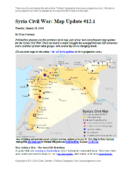
Map of fighting and territorial control in Syria's Civil War (Free Syrian Army rebels, Kurdish groups, Al-Nusra Front, ISIS/ISIL and others), updated to January 28, 2014. Includes recent locations of conflict between ISIS and other rebel groups, including Raqqa, Jarabulus, Manbij, Kafranbel, and others.

Download PDF
buy

(Subscribe via Paypal)

PolGeoNow presents our first premium Syria map, part of our new more frequent updates for the Syrian Civil War! Since last month a major struggle has emerged between ISIS extremists and a coalition of other rebel groups, with several key towns changing hands. See the updated map and briefing in this premium report. Buy now (US$5.99).

Members click here to proceed to article and map

NOT A MEMBER YET? SUBSCRIBE HERE!

Iraq: Map of Al Qaeda Control

There are newer versions of this map available. To see them, view all Iraq updates.

PolGeoNow presents our first map of Iraq, showing control by the government and Al Qaeda rebels in the country’s ongoing crisis. Areas of autonomous Kurdish administration in the north are also indicated.

Want to see timely updates for this map? Subscribe to our premium member service!

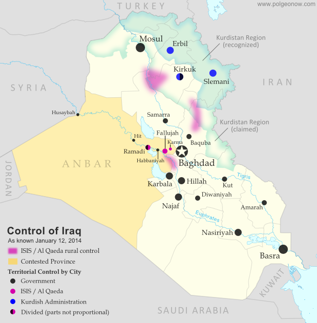
Map of territorial control in Iraq in January 2014, including cities and countryside held by Al Qaeda (ISIS) as well as areas administered by Kurdistan
Territorial control in Iraq at the beginning of 2014. Map by Evan Centanni, starting from this blank map by German Wikipedia user NordNordWest. License: CC BY-SA

Premium members click here to view this article in the ad-free members area. Not a member yet? Subscribe now!

By Evan Centanni

Al Qaeda in Iraq
Though the reality is of course more complex, power politics in Iraq often revolve around the country’s three largest ethnic groups: Shia (Shiite) Arabs, Sunni Arabs, and Kurds (most Kurds are religiously Sunni, but their language and cultural distinguish them from Arabs). Prime Minister Nouri al-Maliki, a Shia Arab, is often accused of manipulating Iraq’s democracy to exclusively serve the country’s Shia majority. The Kurds govern a highly autonomous region in the northeast, but the Sunni Arabs who dominate northwestern Iraq have relatively little political power. Into the fray has jumped Al Qaeda in Iraq, now part of the Islamic State of Iraq and al-Sham (ISIS) organization which also controls parts of Syria (map). Al Qaeda has waged a fierce campaign against the Iraqi government in the name of Sunnis, though the group is still rejected by many of the people it claims to protect.

Past Territorial Control
During the height of the Iraqi insurgency, Al Qaeda controlled large swaths of northern and central Iraq, including areas of the capital, Baghdad. Over the next few years it lost most or all of its territory, but has recently been making a gradual comeback. A map from the Reuters news agency last month shows a surprisingly large number of areas apparently under Al Qaeda’s influence, though scholarly research from the Institute for the Study of War determined just three major areas of control for the group (shown with shading on our map).

Flag of IraqCountry Name:  
• Iraq (English, Kurdish)
• al-‘Irāq (Arabic)
Official Name:  
• Republic of Iraq (English)
• Jumhūriyyat al-‘Irāq (Arabic)
Komara Iraqê (Kurdish)
Capital: Baghdad

Cities Captured
Things changed early this month, when a botched government crackdown resulted in Al Qaeda fighters taking control of the two largest cities in the western province of Anbar. It started when Prime Minister Maliki ordered the army to clear a one-year-old camp of Sunni protesters in the city of Ramadi, which he claimed Al Qaeda was using as a base.

After clashes with enraged local militias, Maliki agreed to withdraw the army. But soon after he did so, Al Qaeda launched a large-scale attack on Ramadi and nearby Fallujah. The army returned, and a three-way struggle ensued between government forces, Al Qaeda, and local militias who supported neither. On January 3, Al Qaeda fighters of ISIS declared Fallujah an independent Islamic state, and both Fullujah and Ramadi were reportedly under partial control of the militants. By the next day, they were said to be in nearly full control of Fallujah, as well as the nearby town of Karma.

ISIS also apparently captured several other towns along the Euphrates River, but a few – including Hit, Habbaniyah, and the Husaybah border crossing with Syria – were quickly retaken by the Iraqi army. Still, to control Anbar’s two major cities is to dominate the province as a whole. And although government forces have been making steady progress in retaking Ramadi, at least 10% of the city is reportedly still under Al Qaeda control. Fallujah still remains in rebel hands, though some local leaders claim that power is held by local militias rather than the ISIS/Al Qaeda fighters.

Graphic of the Iraqi flag is in the public domain (source).

Syria Civil War Map: December 2013 (#12)

There are newer versions of this map available. To see them, view all Syria updates.

In addition to updates on the situation, our updated Syria control map now distinguishes the territory of extremist groups ISIS and Al-Nusra from that of Free Syrian Army or mixed rebel coalitions. (To see other maps in this series, view all Syria updates.)

Tired of waiting months for Syria map updates and briefings? Subscribers to our premium member service will soon begin seeing much more frequent Syria control updates. Don’t miss out – sign up now!

Map of fighting and territorial control in Syria's Civil War (Free Syrian Army rebels, Kurdish groups, Al-Nusra Front, ISIS/ISIL and others), updated for December 2013. Includes recent locations of conflict and territorial control changes, Al-Safira, Khanaser, Maaloula, Qara, Nabek, and .
Area of fighting and territorial control in Syria’s civil war, updated for December 2013. Map by Evan Centanni, starting from this blank map by German Wikipedia user NordNordWest. License: CC BY-SA

Premium members click here to view this article in the ad-free members area. Not a member yet? Subscribe now!

Al-Nusra and the ISIS
In addition to updates on the situation since our previous Syria war map, this edition of the map also shows which cities are controlled primarily by religious extremist groups the Al-Nusra Front and the Islamic State of Iraq and Syria (ISIS) (also translated from Arabic as ISIL, the Islamic State of Iraq and the Levant). While these groups share many of their goals with the Free Syrian Army and other rebel groups fighting the Assad government, and in many cases still cooperate strategically with those groups, they are increasingly emerging as a separate bloc in the multi-sided conflict.

Though most of the rebels in Syria are Sunni Muslims, many of them hope to establish a secular democracy with representation for all Syrians. Al-Nusra and ISIS, on the other hand, base their entire organizations around a violent extremist religious ideology. Both are affiliates of Al Qaeda, and have claimed responsibility for many of the most brutal atrocities committed during the war. Unlike the Free Syrian Army (FSA) and other rebel groups operating in the country, which are apparently made up mostly of native Syrians, Al-Nusra and ISIS include large proportions of foreign fighters. In fact, ISIS is the same group once known as Al-Qaeda in Iraq, and has been part of the insurgency in that country since soon after the Iraq War began in 2003.

Flag of Syria under the current governmentCountry Name:  
• Syria (English)
• Sūriyya/Sūryā (Arabic)
Official Name:  
• Syrian Arab Republic (English)
• al-Jumhūriyyah al-‘Arabīyah  as-Sūriyyah (Arabic)
Capital: Damascus

These two groups have emerged as the most powerful and effective fighting forces in Syria, and are responsible for many of the rebel victories over the last year and beyond. And although the Syrian rebels have rarely if ever been united under a single command, Al-Nusra and ISIS have increasingly stood out not only for their radicalism, but also for their direct conflict with the Free Syrian Army and other groups, often seizing towns from the other rebels by force. Now, enough information is finally available for us to show these groups separately on the territorial control map.

Although most rebel territory in Syria is still occupied by mixed rebel coalitions or FSA affiliates, several cities and towns are now known to be primarily under ISIS and/or Al-Nusra control. ISIS’s area of control is mostly in the northwest, stretching from provincial capital Raqqah to key towns in Aleppo and Idlib provinces, and all the way to the far western rebel outpost of Salma in Latakia province. Al-Nusra, though present across most of the country, is especially known to control territory in the east, where it has held the oil town of Shadadeh for some months now. It has also recently captured the Al-Omar Oil Field, Syria’s largest. Al-Nusra has made headlines in Western countries recently by repeatedly harassing and occupying the historic Christian town of Maaloula north of Damascus.

Government Advances in the North
The largest change in territorial control since our August Syria map update has been the army’s recapture of Al-Safira, a satellite city of Aleppo which is also the location of a major chemical weapons stockpile. Rebels had captured the city early this year, but government forces took it back last month as part of a campaign to reopen the back road from Homs to Aleppo. The nearby town of Khanaser was recaptured one month earlier, after having fallen into rebel hands just after our last update in August.

Ariha, an important town in the northwestern Idlib province, was also recaptured by government forces in early September, after switching back and forth in control more than once over the course of the war.

Damascus and Surroundings
Syria’s capital city of Damascus has continued to be a focal point in the war, with rebel and government forces fighting fiercely for control of its many suburbs (map). Meanwhile, one of the most active fronts in recent weeks has been the area between Damascus and Homs, where the Syrian military and its ally Hezbollah from Lebanon have been trying hard to root rebels out from a mountainous region along the border. In addition to the Christian town of Maaloula mentioned earlier, rebel possessions in this region also include the town of Yabroud, with the government having captured Qara last month and Nabek just a week ago.

The South and East
The southern Syrian province of Daraa has continued to be a major front for fighting over the last several months, with a coalition of various rebel groups capturing the border crossing next to Daraa city in October. Meanwhile, in far northeastern Hasakah, Kurdish militias have seized the Yarabiya border crossing from a coalition of ISIS, Al-Nusra, and other groups. This is the main border crossing into Iraq from northern Syria, though the Kurdish National Council had previously set up a temporary crossing to the north. The area across this border is part of Iraq’s official autonomous Kurdistan Region.

Also in Kurdish-majority Hasakah province, this edition of the map has been adjusted to reflect the fact that the city of Al-Hasakah itself is apparently under partial Kurdish control.

Graphic of the Syrian flag is in the public domain (source).

Map: Palestine Recognized by Two More Countries (134/193)

(Keep up with changes to Palestine’s situation: view all Palestine updates.)

Map of countries that recognize the State of Palestine as an independent country, updated for November 2013 with recent additions Haiti and South Sudan highlighted
Countries recognizing the State of Palestine in green, with most recent additions highlighted. Palestine in magenta (circled). Click to enlarge. Map by Evan Centanni, modified from public domain graphic (source).

By Evan Centanni

List Grows By Two
After being recognized as an Observer State by the U.N. last year to the protest of Israel, the U.S., and other Western countries, the State of Palestine is slowly continuing to receive diplomatic recognition from individual U.N. members. Last May we reported that 132 U.N. member states had officially recognized Palestine, and now the list has grown to 134 (69% of the world body’s total membership). Palestine is also recognized by the proclaimed government of disputed Western Sahara, which is not a member of the U.N.

Flag of Palestine Country Name:  
• Palestine (English)
Filasṭīn (Arabic)
Official Name:  
• State of Palestine (English)
• Dawlat Filasṭin (Arabic)
Capital: 
• Jerusalem (claimed)
Ramallah (administrative)

New Recognition
The most recent country to recognize Palestine as independent is the Caribbean nation of Haiti, which did so near the end of this past September. An official ceremony was held for Haiti’s recognition at U.N. headquarters in New York, in which both Haiti and Caribbean neighbor Grenada signed agreements to establish diplomatic relations with the State of Palestine. However, Grenada has already been on the list for some time, offering its recognition a full two years ago according to the official website of Palestine’s U.N. delegation.

One More Country: Mystery Solved
As discussed in our previous Palestine recognition article, since last year the number of recognitions claimed by Palestine’s U.N. mission has been higher by one than the total number actually documented by observers. However, the confusion has now been cleared up by the publication of an official list on the delegation’s website.

This list includes one more country than previous third-party lists, recording newly independent country South Sudan as having offered its recognition on July 14, 2011, on the same day that it joined the U.N. In retrospect, this should come as no surprise, since South Sudan firmly supported Palestine’s 2011 bid for U.N. membership, and apparently did actually announce that it would grant diplomatic recognition (though that statement occurred later than the date now claimed by Palestine).

Related Articles:
Palestine Recognized as a Country by the U.N.
Is Palestine Really a Country?
Map of Countries Recognizing Kosovo

No More Bangsamoro Republik: Philippine Rebel Occupation Defeated

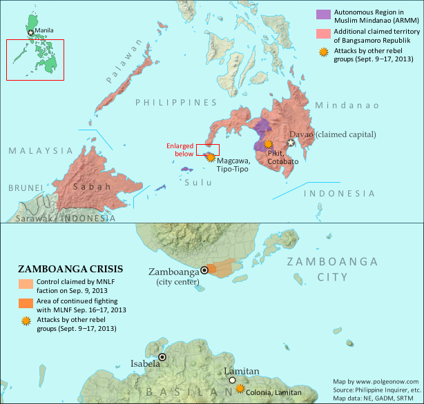
Map of territory in the Philippines and Malaysia claimed by the Bangsamoro Republik, plus territorial control by the Moro National Liberation Front (MNFL) during last month's Zamboanga crisis.
Claims and territorial control of the MNLF rebels and Bangsamoro Republik during last month’s crisis. Click to see full-sized map and article. Map by Evan Centanni.

Territory Retaken by Government
Last month, Political Geography Now mapped Moro rebel control in the Philippines’ Zamboanga crisis. The rebels, drawn from a group which had declared independence from the Philippines as the Bangsamoro Republik, had occupied several neighborhoods of Zamboanga City in the country’s southwest after an aborted attempt to raise their flag in the city center.

Ten days after we published that article, the government of the Philippines declared the crisis over, with all hostages freed and only scattered fighting occurring over the next two days as the surviving rebels attempted to escape the area. After nearly three weeks of chaos, the city of Zamboanga was once again fully under government control.

What of the MNLF fighters?
Though hundreds of rebels from the Moro National Liberation Front (MNLF) were killed in the fighting, some did escape, and the attack’s commander Habier Malik is still missing. Nur Misuari, the faction’s leader and founder of the self-declared Bangsamoro Republik, was not present at the attack but is now wanted on charges of rebellion. But he may have more than just the government to worry about – Malik’s surviving men from the Zamboanga attack are also said to be on the hunt for Misuari, who allegedly tricked them into participating. According to Mujiv Hataman, governor of the officially sanctioned Autonomous Region in Muslim Mindanao (ARMM), Misuari promised Malik’s men that U.N. peacekeepers would arrive soon after the attack to secure Bangsamoro independence and reward each fighter with 10,000 pesos (US $230) and a new weapon.

BIFF Attacks
Attacks by other Moro rebel groups in nearby regions continued until just after Zamboanga was secured. In particular, the Bangsamoro Islamic Freedom Fighters (BIFF), a splinter group from the Moro Islamic Liberation Fighters (MILF) who are currently in peace talks with the Philippine government, continued launching attacks elsewhere in Mindanao into early October. The BIFF is not closely tied to Nur Misuari’s MNLF, and these were apparently just opportunistic attacks taking advantage of the military’s distraction during the crisis in Zamboanga.

More information: Bangsamoro Republik? Philippine Separatists Seize Territory (map)