Map: Which Countries Recognize Palestine in 2014?

(Keep up with changes to Palestine’s situation: view all Palestine updates.)

Map of countries that recognize the State of Palestine as an independent country, updated for December 2014 with recent addition Sweden highlighted
Countries recognizing the State of Palestine in green, with most recent addition highlighted. Palestine in magenta (circled). Click to enlarge. Map by Evan Centanni, modified from public domain graphic (source).

Premium members click here to view this article in the ad-free members area. Not a member yet? Subscribe now!

Article by Evan Centanni

Disputed Country
Palestine declared independence in 1988, and its government continues to pursue recognition as a country today. Though its claimed territories are disputed and largely occupied by Israel, the “State of Palestine” has gathered recognition from more than two-thirds of the world’s countries, and is also treated as a country by the U.N. General Assembly, where it is an “Observer State” but not a member.

The number of individual countries recognizing Palestine as independent has grown gradually over the past decades. A year ago we reported that 134 U.N. member states officially recognized Palestine, and as of December 2014 the number is now 135 (70% of all U.N. members). Palestine is also recognized by the proclaimed government of Western Sahara, another disputed country that’s not formally recognized by the U.N.
Flag of Palestine Country Name:  
• Palestine (English)
Filasṭīn (Arabic)
Official Name:  
• State of Palestine (English)
• Dawlat Filasṭin (Arabic)
Capital: 
• Jerusalem (claimed)
Ramallah (administrative)

Sweden’s Recognition of Palestine
Only one new country has endorsed Palestine’s independence in 2014, but it’s a big one. On October 30, Palestine was officially recognized by Sweden, a major European country and and member of the European Union (EU). This is a big deal because most of Western Europe does not recognize Palestine, and of the 50-60 total countries worldwide that don’t recognize, about half are in Europe.

Palestinian Recognition in Europe
Sweden is the first country to begin recognizing Palestine after becoming a member of of the EU, an organization that tends to take a centrist stance on the Israeli-Palestinian conflict. In recent months, legislatures in France, Spain, Ireland, and the UK have also voted in support of recognizing Palestine, but so far none of their governments has followed through with official recognition.

However, Sweden isn’t the only EU country that endorses Palestine’s claimed independence: Malta, Czechoslovakia, Cyprus, Hungary, Romania, Bulgaria, and Poland all recognized it in 1988, before they became EU members.* Russia, Belarus, Ukraine, Serbia, and Albania also retain recognition from 1988, but are not members of the EU. And yet, neither is Sweden the only European country to recognize Palestine since the end of the Cold War. Bosnia recognized in 1992, Montenegro in 2006, and Iceland in 2011. 

*After the breakup of Czechoslovakia, the Czech Republic and Slovakia inherited their recognition of Palestine, though the current Czech government does its best to ignore that fact, having become a very close ally of Israel. Cyprus, on the other hand, has recently reaffirmed its original position on Palestinian independence. 

Related Articles:
Is Palestine Really a Country?
Palestine Recognized as a Country by the U.N.
Map of Countries Recognizing Kosovo

Syria Civil War Map: December 2014 (Premium)

There are newer versions of this map available. To see them, view all Syria updates.

Detailed map of territorial control in Syria's Civil War (Free Syrian Army and Nusra Front rebels, Kurdish groups, ISIS/ISIL/Islamic State and others), updated to December 2014 for siege of Kobani (Ayn al-Arab), government capture of Morek, rebel capture of Nawa, and other developments.

Download PDF
Buy now

(Subscribe via Paypal to view all premium content online)

Research by T.H., with additional reporting by Evan Centanni

Our popular map of territorial control in the Syrian Civil War has been updated for December 2014, showing changes to the situation since the previous Syria map report in October. 

The map and accompanying report show largely unreported advances by the Islamic State, as well as important gains for both the government and rebels.

This map and report are exclusive premium content, available to paid subscribers or for individual purchase.
Download PDF (US$14.99)

Premium map includes:

  • Up-to-date map of current territorial control in Syria, color-coded for the Assad government, rebel groups, Islamic State (ISIS) extremists, and Kurdish self-protection forces
  • Detailed indication of city-by-city control, highlighting key towns relevant to current events
  • Recent areas of fighting, including Kobani (Ayn al-Arab), Morek, Nawa, and many others
  • Timeline of events since early October, with focus on changes to territorial control

MEMBERS CLICK HERE TO PROCEED TO ARTICLE AND MAP

NOT A MEMBER YET? SUBSCRIBE NOW!

Portuguese Community Admits New Member & Observer Countries (Map)

Map of the Community of Portuguese Language Countries (CPLP), including both member states and associated observers. Updated for the July 2014 summit, which admitted new member Equatorial Guinea and new associate observers Georgia, Japan, Namibia, and Turkey (colorblind accessible).
Map by Evan Centanni, starting from public domain blank map (license: CC BY-NC-SA).

Premium members click here to view this article in the ad-free members area. Not a member yet? Subscribe now!

Article by Karina Barquet

Flag of the Community of Portuguese Language Countries (aka Community of Portuguese-speaking Countries, CPLP)Organization Name:  
• Community of Portuguese Language Countries (English)
• Community of Portuguese-Speaking Countries (English – alternative name)
• Comunidade dos Países de Língua Portuguesa (Portuguese)
Founded: 1996 in Lisbon, Portugal
Headquarters: Lisbon, Portugal
Website: www.cplp.org

New Member Country for CPLP
The Community of Portuguese Language Countries (known by the Portuguese acronym CPLP) welcomed a new member this year. Equatorial Guinea joined the organization following its approval at the 10th CPLP Heads of State Summit in Dili, East Timor on July 23, 2014.

The CPLP is an intergovernmental organization for cooperation amongst countries where Portuguese is an official language. It was  founded in 1996 with seven member countries: Portugal, Brazil, Angola, Cape Verde, Guinea-Bissau, Mozambique, and São Tomé and Príncipe. East Timor joined the community in 2002 after gaining independence.

New Observer Countries
In addition to new member Equatorial Guinea, the CPLP’s July 2014 summit also admitted four new Associate Observer countries: Georgia, Japan, Namibia, and Turkey. These joined the two previously-admitted Associate Observers, Mauritius and Senegal.

Equatorial Guinea is a small country located in Central Africa. Its name reflects the country’s location near both the equator and the Gulf of Guinea. Equatorial Guinea is a former Spanish colony, and Spanish is the first official language, followed by French. A new law drafted in 2011 declared Portuguese the third official language in the country, though it is unclear whether that law ever went into effect.

The push to adopt Portuguese as an official language was a result of President Obiang’s efforts in 2007 to improve communications, trade, and bilateral relations with Portuguese-speaking countries, and to meet an important requirement to become a full member of the CPLP. Other requirements for joining CPLP included political reforms to give room for effective democracy and respect for human rights.

The 10th Summit also saw the reincorporation of Guinea-Bissau as a full member of the CPLP, after its suspension following a coup d’etat in April 2012. Guinea-Bissau was readmitted in the wake of the country’s recent presidential and legislative elections, and the transition of the CPLP’s presidency from President of Mozambique, Armando Guebuza, to the President of East Timor, Matan Ruak, who will be in office for the next two years.

Low-resolution graphic of the CPLP flag is displayed under fair use principles (source).

War in Iraq: Map of Control in October 2014 (#4) (Premium)

There are newer versions of this map available. To see them, view all Iraq updates.

Detailed map of control in Iraq in late October 2014, including territory held by the Islamic State (ISIS, ISIL), the Baghdad government, and the Kurdistan Peshmerga.

Download PDF
Buy now

(Subscribe via Paypal to view all premium content online)

Research by Djordje Djukic and Evan Centanni

PolGeoNow presents our latest update on territorial control in Iraq, which is still split three ways between the Baghdad government, the Kurdistan Regional Government, and the Islamic State (ISIS). This report covers a number of important changes to territorial control since our last Iraq map update in August.

This map and article are exclusive premium content, available only to paid members or for individual purchase. Buy now (US$9.99)

Premium map includes:

  • Up-to-date map of current territorial control in Iraq, color-coded for the Iraqi government, ISIS/Islamic State extremists, and Kurdish Peshmerga forces
  • Detailed indication of city-by-city control, highlighting key towns relevant to current events
  • Includes recent areas of fighting including Hit, Jurf al-Sakar, Mosul Dam, Jalula, and more
  • Timeline-style report on changes to the situation since August, with links to sources

MEMBERS CLICK HERE TO PROCEED TO ARTICLE AND MAP

NOT A MEMBER YET? SUBSCRIBE NOW!

Map: “Eurasian Union” Gets New Member

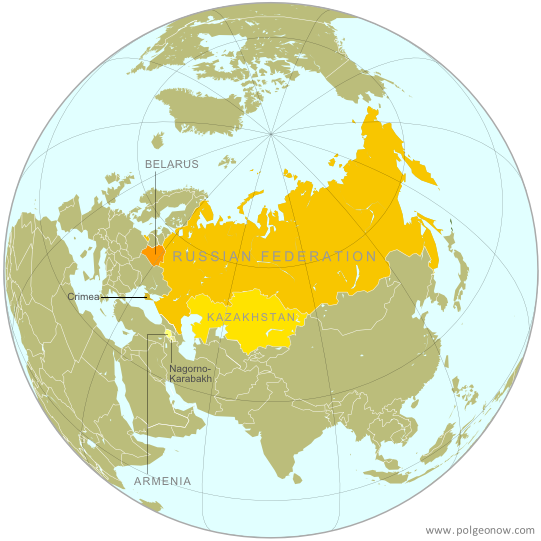
Map of the Eurasian Economic Union (EEU), also known as the Eurasian Union. Includes new member Armenia, as well as prior members Russia, Belarus, and Kazakhstan, and disputed territories Crimea and Nagorno-Karabakh.
The Eurasian Economic Union’s four member countries, plus disputed territories that might be officially or unofficially included. Map by Evan Centanni, starting from this map by Keverich2. License: CC BY-SA

Premium members click here to view this article in the ad-free members area. Not a member yet? Subscribe now!

Article by Evan Centanni

Armenia Joins Eurasian Economic Union
The Eurasian Economic Union (EEU), widely seen as a Russian-led answer to the European Union (EU), just welcomed its fourth member country. Armenia, a small former Soviet republic in the Caucasus region of Western Asia, joined Russia, Belarus, and Kazakhstan in the trade bloc after signing the organization’s founding treaty last Friday, October 10. However, the EEU, which will unite the four member countries’ economies into a single cooperatively-managed entity, doesn’t officially go into effect until New Year’s Day (January 1, 2015).

Flag of ArmeniaCountry Name:  
• Armenia (English)
• Hayastan (Armenian) 
Official Name:  
• Republic of Armenia (English) 
• Hayastani Hanrapetutyun (Armenian)
Capital: Yerevan

What is the “Eurasian Union”?
Though sometimes called just the “Eurasian Union”, the EEU is for now strictly economic in nature. Russia has shown interest in eventually expanding it into a political union to match the EU – however, that path is unpopular with fellow founding member Kazakhstan, which sees political union as a threat to the independence it gained after the breakup of the Soviet Union in 1991.

The economic union hopes to increase trade and lower prices by establishing a “Single Economic Space,” where goods, services, money, and people can all move freely from country to country without the obstruction of borders or import taxes. Industrial development, agriculture, and transportation will also be managed cooperatively, and people from one country will be able to live and work in any of the other countries without a visa.

What’s the difference: Eurasian Economic Union, EURASEC, and the Customs Union
Though the EEU has not yet gone into effect, Russia, Belarus, and Kazakhstan are already united in an organization called “the Customs Union“. This union partially combines the countries’ economies by replacing customs checks along their mutual borders with a unified customs policy for all imports coming into the three-country bloc. Armenia is apparently still not a member of the Customs Union, though the issue will presumably become moot on January 1, when the Customs Union is replaced with the new EEU.

The EEU is not the same thing as the Eurasian Economic Community (EURASEC), an earlier attempt at economic integration among former Soviet countries. EURASEC includes more countries than the EEU, but its members’ economies are not closely unified. The EEU in many ways grew out of the broader organization, and the member countries have agreed to dissolve EURASEC once the EEU comes into force on January 1, 2015.

Armenia’s Path to Membership
Armenia had originally sought to join the Customs Union this past spring, in advance of the EEU treaty coming into effect. However, its membership has been repeatedly delayed. Many suspect this was because of disagreements with the current Customs Union member countries over the Nagorno-Karabakh Republic, an Armenian-backed breakaway state that the rest of the world considers to be part of the neighboring ex-Soviet country of Azerbaijan. Even Armenia doesn’t officially recognize Nagorno-Karabakh, which declared independence in 1991, but makes no secret of being the breakaway state’s main supporter.

Map of the breakaway Nagorno-Karabakh Republic relative to Armenia and Azerbaijan
The breakaway Nagorno-Karabakh Republic (NKR)
Orange: Former NK Autonomous region in USSR
White: Current NKR territorial control
(public domain map by VartanM and Kmusser; source)

Because Armenia doesn’t maintain any border checks along its boundary with Nagorno-Karabakh, questions have been raised about whether the disputed territory will become an unofficial part of the EEU along with Armenia. With the other EEU members insisting Nagorno-Karabakh can’t be part of the union, and Armenia insisting it won’t set up border checks, it’s unclear how this issue will be resolved.

Meanwhile, another disputed territory will almost certainly be treated as part of the EEU, and officially at that. Crimea, recognized by the rest of the world as part of Ukraine, came under Russian control after a hostile takeover earlier this year. Since Russia, the most powerful member of the new EEU, considers Crimea a legitimate part of its territory, it seems unlikely the region will be excluded in any way from the new economic union.

Graphic of the Armenian flag is in the public domain (source).

Syria Civil War Map: October 2014 (#15) (Premium)

There are newer versions of this map available. To see them, view all Syria updates.

Detailed map of territorial control in Syria's Civil War (Free Syrian Army and Nusra Front rebels, Kurdish groups, ISIS/ISIL/Islamic State and others), updated to October 2014 for siege of Kobani (Ayn al-Arab) and other developments.

Download PDF
buy

(Subscribe via Paypal to view all premium content online)

Our territorial control map of the Syrian Civil War has been updated for October, showing changes to the situation since the previous Syria map report in September. The map and accompanying timeline show the Islamic State’s advance against Kurdish-held Kobani, as well as other developments from the past few weeks.

This map and article are exclusive premium content, available to paid subscribers or for individual purchase.
Buy now (US$9.99)

Premium map includes:

  • Up-to-date map of current territorial control in Syria, color-coded for the Assad government, rebel groups, Islamic State (ISIS) extremists, and Kurdish self-protection forces
  • Detailed indication of city-by-city control, highlighting key towns relevant to current events
  • Recent areas of fighting, including Kobani (Ayn al-Arab), Deir al-Adas, and others
  • Timeline of events since mid-September, with focus on changes to territorial control

MEMBERS CLICK HERE TO PROCEED TO ARTICLE AND MAP

NOT A MEMBER YET? SUBSCRIBE NOW!

Syria Civil War Map: September 2014 (#14) (Premium)

There are newer versions of this map available. To see them, view all Syria updates.

Detailed map of fighting and territorial control in Syria's Civil War (Free Syrian Army and Nusra Front rebels, Kurdish groups, ISIS/ISIL/Islamic State and others), updated to September 2014.

Download PDF
buy

(Subscribe via Paypal to view all premium content online)

Our Syrian Civil War coverage continues with this updated situation map, showing changes to territorial control since our previous Syria map report in August. Government forces, the Islamic State (ISIS), and the allied rebels have all made territorial gains during the past weeks.

This map and article are exclusive premium content, available to paid subscribers or for individual purchase.
Buy now (US$9.99)

Premium map includes:

  • Up-to-date map of current territorial control in Syria, color-coded for the Assad government, rebel groups, Islamic State (ISIS) extremists, and Kurdish self-protection forces
  • Detailed indication of city-by-city control, highlighting key towns relevant to current events
  • Recent areas of fighting including Tabqa Airbase, Halfaya, Quneitra Province and more
  • Timeline of events since mid-August, including both territorial changes and major political happenings

MEMBERS CLICK HERE TO PROCEED TO ARTICLE AND MAP

NOT A MEMBER YET? SUBSCRIBE NOW!

Syria Civil War Map: August 2014 (#13)

There are newer versions of this map available. To see them, view all Syria updates.

Premium subscribers have already seen our new Syria map format, which shows full areas of control for each major faction in the civil war. Now, we present this month’s update free of charge for your convenience. 

To get many more Syrian Civil War map updates like this one, sign up now for a premium subscription!

Map of fighting and territorial control in Syria's Civil War (Free Syrian Army rebels, Kurdish groups, Al-Nusra Front, Islamic State (ISIS/ISIL) and others), updated for August 2014. Highlights recent locations of conflict and territorial control changes.
Territorial control in the Syrian Civil War as of August 2014. Map by Evan Centanni, starting from blank map by NordNordWest. License: CC BY-SA

Premium members click here to view this article in the ad-free members area.

Threats from All Sides
Since our last Syria map update in early July, the lines of control in the civil war have not changed drastically. However, fighting on all fronts has resulted in numerous small but important changes to the situation, as the Assad government is now facing serious challenges from both the newly rebranded Islamic State (formerly ISIS/ISIL) and a loose coalition of various other rebel groups (including both the Free Syrian Army and Al-Nusra).

Rebel Advances
Opposition forces made advances against the army in two parts of Hama province over the past month, beginning in mid-July with their capture of Rahjan in the province’s east. Before the end of the month, they had also advanced nearly to the city of Hama, by some accounts fully capturing Khitab and nearby towns. In early August, major fighting erupted in Arsal, a town across the border in Lebanon. Rebels recently driven out of nearby Syrian areas struggled with the Lebanese army over several days before eventually retreating.

Flag of Syria under the current governmentCountry Name:  
• Syria (English)
• Sūriyya/Sūryā (Arabic)
Official Name:  
• Syrian Arab Republic (English)
• al-Jumhūriyyah al-‘Arabīyah  as-Sūriyyah (Arabic)
Capital: Damascus

Rebel Setbacks
However, signs of a rift among the rebel coalition may be emerging. Similarly to how ISIS began carving out its own territory late last year, the rebel Al-Nusra Front last month declared its own “emirate” and seized the northwestern towns of Salqin, Harem, and Darkush from formerly allied rebel groups. The powerful Al-Nusra Front is an official affiliate of Al Qaeda, but has up to now cooperated and mixed freely with less extreme anti-government rebels. It remains to be seen whether recent events signal a permanent split.

The rebels, including Al-Nusra, have also suffered some defeats. Formerly the major power in Syria’s eastern Deir ez-Zor province, they have now been completely driven out, with the Islamic State last month replacing them in Deir ez-Zor city and driving them out of their last territories to the city’s northwest (the Islamic State’s main campaign for Deir ez-Zor province was covered in last month’s update).

Within Syria’s largest city of Aleppo, rebel fighters also were driven back from some of their positions by an early-July government advance.

Consolidating the “Caliphate”
Above all, the past month has seen a strengthening of the “Islamic State” group, formerly known as the Islamic State of Iraq and al-Sham (ISIS). After seizing much of neighboring Iraq in June, ISIS declared itself to be the Caliphate, a historical term for an empire of all Muslims, and shortened its name to “Islamic State”. Controlling the major Iraqi city of Mosul, it has used this newfound power to consolidate its territories in both countries.

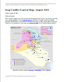
Map of the Islamic State's control in Iraq as of August 2014
The Islamic State’s control in Iraq (click for premium article and map).

In Syria, the Islamic State has nearly completed its control of Raqqah province. Though it already held the capital, three key military bases in the province were still controlled by the Assad government. Two of those, known as Division 17 and Brigade 93, were seized by the Islamic State earlier this month, while the last, Tabqa Airbase, is now under siege. In neighboring Hasakah province, Islamic State fighters also captured a key government base, the 121st Artillery Regiment, even waging battles on the outskirts of Hasakah city and advancing nearly to Qamishli on the Turkish border. However, government forces also scored some victories, maintaining joint control of the city with Kurdish forces and at one point pushing the militants back towards their stronghold in Shadadi.

Islamic State Advances West
The Islamic State has also begun striking out west from its current territories in both the north and the south. In Aleppo province it has been very slowly taking back ground it lost to the rebel coalition in January, seizing the town of Akhtarin just last week. Meanwhile, it has also been pushing against the Kurdish enclave of Kobane (Ayn al-Arab) from both sides. More prominently, Islamic State forces last month boldly stormed the Sha’er gas field near Palmya, far from their established frontiers, though the government soon recaptured it.

But pockets of Islamic State control have been appearing even farther afield, possibly in connection with the group’s efforts to bring small rebel brigades over to its side. Some reports say the town of Deir Ful near Homs city is now in Islamic State hands, and the group briefly captured a neighborhood outside Damascus last month.

Don’t miss future updates to the Syria and Iraq control maps! Become a member now!

Graphic of the Syrian flag is in the public domain (source).

Iraq Conflict Control Map: August 2014 (Premium)

There are newer versions of this map available. To see them, view all Iraq updates.

Detailed map of territorial control in Iraq in August 2014, including cities and countryside held by the Islamic State (ISIS, ISIL) and the Kurdistan Peshmerga.

Download PDF
buy

(Subscribe via Paypal to view all premium content online)

This is the latest update to our series of maps documenting territorial control in the current war in Iraq, with a number of updates since the previous edition in late June. 

It includes control by the Maliki goverment, Kurdish forces, and the Islamic State (formerly known as ISIS), and has been re-styled to fit seamlessly with our popular control maps of the Syrian Civil War.

This map and article are exclusive premium content, available only to paid members or for individual purchase. Buy now (US$9.99)

Premium map includes:

  • Up-to-date map of current territorial control in Iraq, color-coded for the Maliki government, ISIS/Islamic State extremists, and Kurdish forces
  • Detailed indication of city-by-city control, highlighting key towns relevant to current events
  • Includes recent areas of fighting including Sinjar, Qaraqosh, Mosul Dam, Erbil province, and more
  • In-depth article summarizes changes since June, including ISIS’s declaration of an Islamic caliphate, with links to sources

MEMBERS CLICK HERE TO PROCEED TO ARTICLE AND MAP

NOT A MEMBER YET? SUBSCRIBE NOW!

Map: Yemen Joins WTO

Premium members click here to view this article in the ad-free members area. Not a member yet? Subscribe now!

Map of World Trade Organization (WTO) member and observer countries, updated for July 2014 to include new member Yemen
Member and observer states of the World Trade Organization (WTO). Map by Evan Centanni, starting from public domain blank map (license: CC BY-NC-SA).

By Caleb Centanni 

World Trade Organization Admits Yemen 

The World Trade Organization (WTO), a global organization founded in 1995 to promote the management and expansion of international trade, added Yemen as a new member in late June. This comes after the admission of four new members in 2012, and two more in early 2013.

Logo of the World Trade Organization (WTO) Organization Name:  
• World Trade Organization (English)
• Organisation mondiale du commerce (French)
• Organización Mundial del Comercio (Spanish)
Founded: 1994 in Marrakech, Morocco (commenced in 1995)
Headquarters: Geneva, Switzerland
Website: www.wto.org

Yemen, located on the southern Arabian Peninsula, was approved for membership last October at the Ninth Ministerial Conference of the WTO in Bali, Indonesia. The nation officially became a member on June 26, 2014, placing the entire peninsula under the organization’s representation. Yemen’s admission comes despite recent political turmoil in the country, including an Arab Spring uprising and rebel control of large areas of its territory. Yemen is the seventh least developed member country according to the WTO.

According to the WTO, 97.1% of the world economy now falls under the body’s jurisdiction, and this newest accession brings the organization’s membership to 160. Of the 195 UN-recognized countries in the world, 156 (exactly 80%) are members of the WTO. Another four members are not UN-recognized nations: the Chinese administered territories of Hong Kong and Macau, the European Union, and the disputed state of Taiwan, which participates under the name “Separate Customs Territory of Taiwan, Penghu, Kinmen and Matsu (Chinese Taipei)”.  

There are also 24 WTO “observers”, states that are partially included in the organization and have applied for membership (excepting the Holy See, which does not plan to apply). There are only 14 UN members which are neither members nor observers of the WTO.

WTO logo is displayed without permission, based on fair use principles (source).